TP10 | Planetary Cryospheres: Ices in the Solar System

TP10

Planetary Cryospheres: Ices in the Solar System
Co-organized by OPS
Conveners: Giovanni Munaretto, Silvia Bertoli, Nicole Costa, Matteo Teodori, Alice Lucchetti, Luca Maggioni, Ariel Deutsch, Frances E. G. Butcher, Costanza Rossi
Orals MON1
| Mon, 07 Sep, 08:30–09:59 (CEST)|Room Neptune (Spinoza Foyer)
Orals MON2
| Mon, 07 Sep, 11:00–12:26 (CEST)|Room Neptune (Spinoza Foyer)
Posters MON-POS
| Attendance Mon, 07 Sep, 18:00–19:30 (CEST) | Display Mon, 07 Sep, 08:30–19:30|Foyer 2, F2.25–33
Mon, 08:30
Mon, 11:00
Mon, 18:00
Planetary cryospheres encompass environments enriched of volatile ices, in the form of frost deposits, polar caps, glaciers, and permafrost. Cryospheres are found across the entire Solar System at very different heliocentric distances: on Earth, ice plays a crucial role in landscape evolution, is a key hydrological resource, and acts as a valuable paleoclimatic indicator.
The Martian polar caps exhibit analogous features to those on Earth, including surface modification and associated landforms, but they also contain CO₂ ice. At mid-latitudes, periglacial landforms, such as polygonal terrains indicate the presence of subsurface ice, while glacier-like features contain relict ice and provide evidence of past glacial activity. Moreover, airless bodies such as Mercury and the Moon host icy deposits within the permanently shadowed regions of their polar craters. Similarly, dwarf planet Ceres presents surface and near-subsurface water ice, along with geomorphological and compositional evidence for volatile-driven activity. Further away, beyond the Solar System’s frost line, water ice becomes the dominant compositional endmember. All satellites of Jupiter and Saturn have icy crusts. For some of them (Europa and Enceladus) we have clues which imply the presence of internal oceans. In addition to water ice, CO₂ and CH₄ also condense into cryospheres at extremely low temperatures.
Therefore, studying ice on various planetary bodies is crucial for understanding their composition, geological history, climate evolution, and the processes which distributed water and other ices around the solar system.
This session welcomes a broad range of contributions, including remote sensing (e.g., geomorphic, geophysical and compositional analyses), numerical modelling, and laboratory experiments, as well as research incorporating terrestrial analogues.

Orals MON1: Mon, 7 Sep, 08:30–09:59 | Room Neptune (Spinoza Foyer)

Chairpersons: Silvia Bertoli, Frances E. G. Butcher, Giovanni Munaretto
08:30–08:32
08:32–08:47
|
EPSC2026-118
|
ECP
|
On-site presentation
Apolline Leclef, Mathieu Vincendon, Cateline Lantz, Rosario Brunetto, Pamela Cambianica, Gianrico Filacchione, Andrea Raponi, Mauro Ciarniello, Fabrizio Capaccioni, and Gabriele Cremonese

Introduction: Radar observations of Mercury’s poles revealed bright features within its Permanently Shadowed Regions (PSRs), interpreted as water ice [1]. Subsequent neutron measurements by MESSENGER supported this hypothesis, indicating water-equivalent hydrogen-saturated soil and potential water ice layers a few meters thick [2]. The origin of this ice remains uncertain, with scenarios including endogenic (e.g., volcanism) or exogenic sources via hydrated asteroids/comets (containing ~50% H₂O in comets, up to 10-20% in asteroids [3]) or solar wind implantation [4]. Impacts could also deliver other volatiles, notably CO₂ [3,5], suggesting CO₂ ice may coexist with H₂O in Mercury’s PSRs [6,7]. Temperature maps and sublimation rates [6,8] even indicate that some northern PSRs have conditions conducive to CO₂ cold traps.

Building on previous spectral simulations of H₂O/CO₂ mixtures [9], our work incorporates complementary laboratory experimental approach to also investigate possible interactions at molecular level between H₂O and CO₂.

The SIMBIO-SYS instrument [10] aboard BepiColombo, and particularly its VIHI channel [11], will soon observe these regions. We thus further account for PSR illumination conditions and Signal-to-Noise Ratio (SNR) instrumental constraints to calculate Band Detection Limits (BDL) for selected diagnostic features, to evaluate the detectability of CO₂ ice in H₂O mixtures on Mercury’s surface.


Method and results: VIHI/SIMBIO-SYS [10,11] is a Vis-NIR spectrometer (0.4–2.0 µm, 6.25 nm sampling, 125 m spatial resolution at 400 km altitude), partially covering CO₂ ice absorption features at 1.4 µm and 2.0 µm. We deposited H₂O/CO₂ ice mixtures using INGMAR [12,13], under conditions relevant to Mercury’s PSR, to measure the spectral reflectance in the 1 µm – 5 µm range. Thick ice layers were produced at 50 K under a chamber pressure of ~5 × 10⁻⁷ mbar. The substrate was an InfraGold surface coated with a residual organic film formed by irradiation of a CH₃OH:NH₃ mixture, with an estimated thickness below 1 µm. Spectra were acquired in bidirectional reflectance, with illumination, emergence, and phase angles of 20°, 15°, and 15°, respectively. Measurements were performed at a spectral resolution of 2 cm⁻¹, using 256 scans or 512 scans. Pure CO2 and amorphous H2O were produced as references, alongside 3 different mixtures : 20%, 33% and 50% of CO2. These proportions are set by the relative partial pressures of the injected gases in the chamber for each mixture.

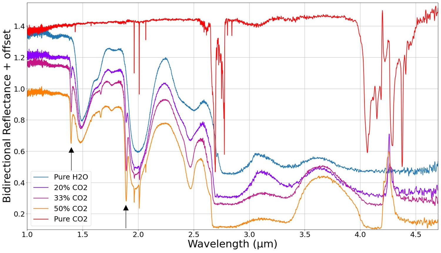
Figure 1: High Resolution experimental data of intimate mixtures between H2O/CO2 ices. Experimental deposition of H2O/CO2 ice mixtures for various CO2 ratio (0 to 100 %), for layers of ~100 µm thick (and ~20 µm for pure CO2). Black arrows show the position of the OH-dangling combinations bands of H2O ice at 1.39 and 1.89 µm.
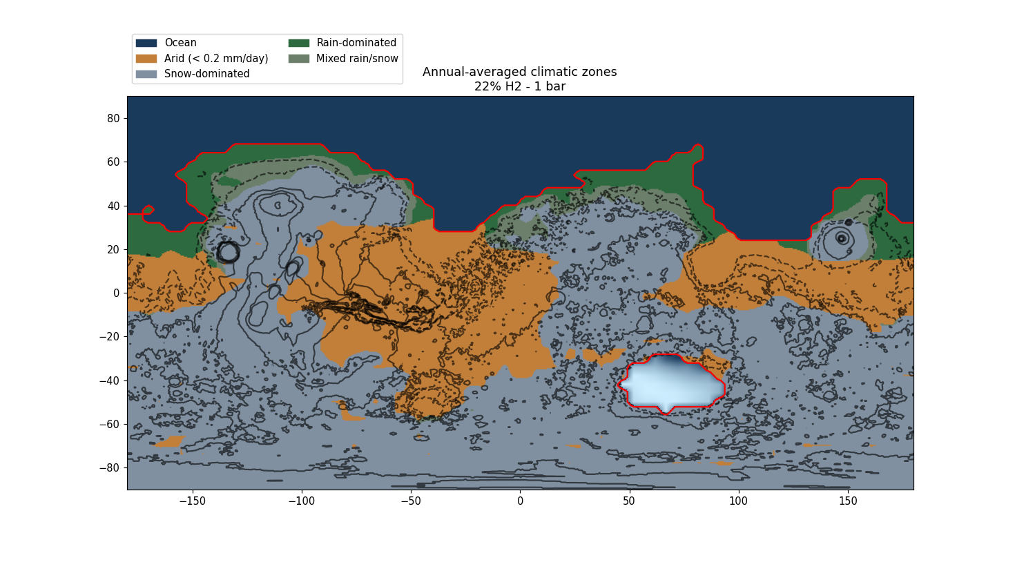
Fig. 1 shows experimental spectra for mixtures of H2O/CO2, with diverse CO2 ratio, at 50K. These spectra exhibit the behaviour of spectral features for various CO2 ratio in the mix (0 to 100%). Here, the intensity of CO2 features increase with the CO2 ratio in the mix. This trend is primarily evident in the 1.0–2.2 µm range, particularly for bands at 1.43 µm and 1.96 µm, which are of direct relevance for VIHI observations. The 2.01 μm band, slightly outside the spectral range of VIHI, is following the same behaviour. The 1.43 µm band is barely detected, while those at 1.96 µm and 2.01 µm offer stronger band depth. Beyond 2.2 µm, absorption features of CO2 become saturated due to the thickness of the deposited ice layers. In this spectral interval, strong OH-dangling overtone combinations bands are also detected at 1.39 µm and 1.89 µm (also seen in [14, 15] but weaker), varying alongside the CO2 ratio in the mix as well, as also seen in previous studies [14]. Their intensity varies consistently with CO2 content, as also seen in [16] for the fundamental OH-dangling, and they are both broader and stronger than nearby CO2 features. These bands are absent in pure H2O, indicating that their presence is directly associated with the incorporation of CO2 within the ice matrix.

These spectral signatures were then modelled under realistic illumination conditions representative of Hermean PSRs, focusing on Kandinsky crater in the Northern Hemisphere, following the methodology described in [17]. The results indicate that OH dangling features remain detectable under expected environmental conditions, whereas CO2 absorption bands are significantly less robust.


Conclusions: Our experimental simulations revealed the emergence of OH-dangling combination bands at 1.39 µm and 1.89 µm, which are directly linked to the presence of CO2 in the ice matrix. These bands are systematically deeper and broader than CO2 absorption features and increase in intensity with higher CO2 ratios in the mixture. While CO2 band may be challenging to detect under PSR conditions, the OH-dangling bands may offer a more reliable, even if indirect, indicator of CO2 presence in H2O ice, particularly with the detection limits anticipated for VIHI/SIMBIO-SYS instrument.


Acknowledgments: The leading authors would like to thank all the people on SIDONIE who helped us during the experimentations, and the CNES for funding.


References: [1] Harmon J. K. et al. (2011) Icarus, 211, 37–50. [2] Lawrence D. J. et al. (2013) Science, 339, 292–296. [3] Altwegg et al. (2019), Annu. Rev. Astron. Astrophys. 57:113–55. [4] Tucker O. J. et al. (2019) Journal of Geophysical Research: Planets, 124, 278-293. . [5] Neumann G. A. (2013), Science, 339, 296–300. [6] Ahrens et al. (2022) Geosciences, 12, 51. [7] Schorghofer N. et al. (2021) Geophysical Research Letters, 48, e2021GL095533. [8] Paige D. A. et al. (2013) Science, 339, 300–303. [9] Leclef, A. et al. (2024). European Planetary Science Congress, EPSC2024-411. [10] Cremonese G. et al. (2020), Space Sci Rev, 216, 75.  [11] Capaccioni F. et al. (2005), AAS/Division for Planetary Sciences Meeting Abstracts, Vol. 37,  #37, 57.02. [12] Lantz C. et al. (2017), Icarus, 285, 43. [13] Hénault E. et al. (2025), Astronomy & Astrophysics, 694, A126. [14] Bernstein, M. et al. (2005), Icarus, 179(2), 527–534. [15] Fulvio, D. et al. (2010), Astronomy and Astrophysics, 511, A62. [16] Öberg, K. et al. (2007), Astronomy and Astrophysics, 462(3), 1187–1198. [17] Filacchione, G. et al. (2020), Monthly Notices of the Royal Astronomical Society, 498, 1308.

How to cite: Leclef, A., Vincendon, M., Lantz, C., Brunetto, R., Cambianica, P., Filacchione, G., Raponi, A., Ciarniello, M., Capaccioni, F., and Cremonese, G.: Hunting CO₂ in Mercury’s PSRs with VIHI/SIMBIO-SYS: how OH-dangling bands can help its detection., Europlanet Science Congress 2026, The Hague, The Netherlands, 7–11 Sep 2026, EPSC2026-118, https://doi.org/10.5194/epsc2026-118, 2026.

08:47–08:59
|
EPSC2026-81
|
ECP
|
On-site presentation
Baptiste Desoubrie, Frédéric Schmidt, Michael J. Way, and Igor Aleinov

Context

The question of the existence of an ocean on Mars near the Hesperian-Amazonian transition has raised considerable controversy. Over the past decade, several studies have highlighted geomorphological evidence consistent with a Northern ocean hypothesis: tsunami deposits (Rodriguez, 2016; Costard, 2017), the identification of Lomonosov crater as a potential impact source for such tsunamis (Costard, 2019), paleoshoreline features (Li et al., 2025) and more.

On the other hand, the long-term stability of an ocean, whether in a warm-and-wet or cold-and-dry climate, has never been achieved with three-dimensional General Circulation Models (3D-GCMs) (Turbet, 2019; Kamada, 2022). Slab ocean simulations find that the ocean either freezes completely or causes water to accumulate as ice over the southern highlands, and that warm-enough scenarios produce intense rainfall and erosion near the shorelines, inconsistent with the geomorphological record.

However, a fully coupled dynamic ocean model can sustain a cold-and-wet climate regime with a stable ocean, while also reducing precipitation near the shorelines due to the lower mean global temperature (Schmidt, 2022). Building on this, Schmidt (2025) proposed a fully equilibrated water cycle by coupling the 3D-GCM with a simple ice sheet model.

Following Schmidt (2022), this study explores the parameter space allowing a stable ocean in a periglacial climate, further relaxing the constraints on both rainfall erosion and atmospheric conditions.

Methods

We use the updated version of ROCKE-3D, a 3D-GCM developed for terrestrial climate studies (Way et al., 2017; Tsigaridis et al., 2025), with a fully coupled dynamic ocean model. Simulations are run for ~ 100 Martian years to reach radiative equilibrium.

Results

Figure 1 : Climatic zones obtained for a 1-bar atmosphere composed of CO2 with 22% H2.

Each climatic zone is defined from diagnostics averaged over the last 10 years of the simulation. Arid regions are identified using a threshold on total precipitation (rainfall + snowfall accumulation). Snow-dominated regions correspond to areas receiving at least twice as much rainfall as snowfall. Intermediate regions corresponds to mixed precipitation regimes.

This simulation exhibits a global mean surface temperature of approximately -6.7°C and an ocean mean temperature of ~ 6.4°C, leading to substantial rainfall over most regions located near the paleoshorelines. Such widespread rainfall could be reduced under colder climate conditions.

References

Costard, F., Séjourné, A., Kelfoun, K., et al., (2017). Modeling tsunami propagation and the emplacement of thumbprint terrain in an early Mars ocean. Journal of Geophysical Research: Planets

Costard, F., Séjourné, A., Lagain, A., Ormö, J., Rodriguez, J., Clifford, S., et al. (2019). The Lomonosov crater impact event: A possible mega‐tsunami source on Mars. Journal of Geophysical Research: Planets

Kamada, A., Kuroda, T., Kodama, T., Kasaba, Y., & Terada, N. (2022). Evolution of ice sheets on early Mars with subglacial river systems. Icarus

Li, J., et al., 2025. Ancient ocean coastal deposits imaged on Mars. Proceedings of the National Academy of Sciences

Rodriguez, J. A. P., et al., 2016. Tsunami waves extensively resurfaced the shorelines of a receding, early Martian ocean. Scientific Reports

F. Schmidt,M.J. Way,F. Costard,S. Bouley,A. Séjourné, & I. Aleinov, (2022)  Circumpolar ocean stability on Mars 3 Gy ago, Proc. Natl. Acad. Sci. U.S.A. 119

Schmidt, F., Way, M. J., Quiquet, A., Aleinov, I., & Dumas, C. (2025). Ancient Mars climate with a polar ocean and ice sheet dynamics. Journal of Geophysical Research: Planets

Tsigaridis, K., Ackerman, A. S., Aleinov, I., Chandler, M. A., Clune, T. L., Colose, C. M., Del Genio, A. D., Kelley, M., Kiang, N. Y., Leboissetier, A., Perlwitz, J. P., Ruedy, R. A., Russell, G. L., Sohl, L. E., Way, M. J., and Wolf, E. T. (2025) ROCKE-3D 2.0: an updated general circulation model for simulating the climates of rocky planets, Geosci. Model Dev., 18

Turbet,M., & Forget,F. (2019) The paradoxes of the Late Hesperian Mars ocean. Scientific Reports

Way, M. J., Aleinov, I., Amundsen, D. S., Chandler, M. A., Clune, T. L., Del Genio, A. D., et al. (2017). Resolving orbital and climate keys of Earth and extraterrestrial environments with dynamics (ROCKE‐3D) 1.0: A general circulation model for simulating the climates of rocky planets. The Astrophysical Journal ‐ Supplement Series, 231(1), 12

How to cite: Desoubrie, B., Schmidt, F., Way, M. J., and Aleinov, I.: Late Hesperian Ocean with a Cold Climate Regime, Europlanet Science Congress 2026, The Hague, The Netherlands, 7–11 Sep 2026, EPSC2026-81, https://doi.org/10.5194/epsc2026-81, 2026.

08:59–09:11
|
EPSC2026-334
|
ECP
|
On-site presentation
Lison Cavalié, Victor Belissa, Sabrina Carpy, and Tanguy Bertrand

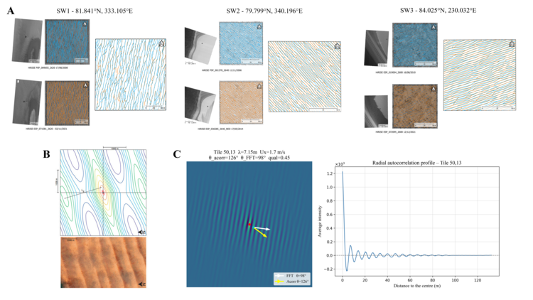
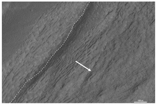
Introduction: The Martian North Polar Cap (MNPC), mainly composed of water ice, is shaped by seasonal cycles of CO₂ and H₂O ice condensation and sublimation [1,2]. During winter, the surface is covered by seasonal CO₂ frost, which sublimates in spring and summer, exposing the underlying water-ice cap to extremely dry atmospheric conditions that enhance sublimation [1,3]. Turbulent katabatic winds flowing over the polar cap during spring and summer [4] influence surface–atmosphere interactions and ice redistribution. These processes generate various aeolian and depositional landforms, including linear ridges interpreted as sublimation waves [5–8]. HiRISE images near Boreales Scopuli and Olympia Cavi reveal regular parallel ridges with wavelengths of ~7 m, oriented perpendicular to prevailing winds and showing little evidence of migration [7,8]. Similar features are also observed in Antarctic blue-ice fields and may correspond to Pluto’s Bladed Terrain Deposits [9–12]. The main objective of this study is therefore to identify which bedforms can confidently be interpreted as sublimation waves, test whether existing scaling laws reproduce their morphometric properties, and assess whether they can be used as proxies for near-surface wind dynamics. We combine morphometric analyses, mesocales estimation, and scaling laws to investigate metric-scale bedforms across the Martian North Polar Cap. 

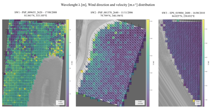
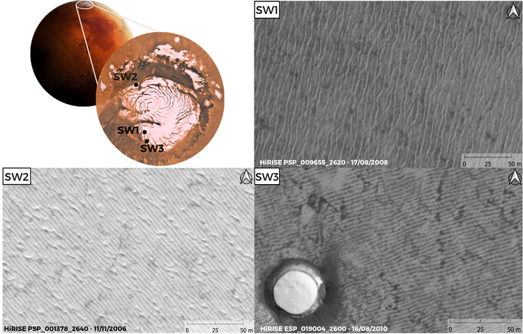
Methods: We analysed candidate sublimation waves using 25cm/px HiRISE images from three sites on the MNPC: two in Gemina Lingula (SW1 and SW3) and one in Tenuis Mensa (SW2) (Fig. 1). Multi-year image series were used to assess temporal changes in ridge morphology. Crestlines were manually mapped in QGIS to measure ridge orientation and wavelength distributions. To extend the analysis over complete HiRISE scenes, we applied an autocorrelation approach [13]. Images were divided into 750 × 750-pixel tiles, and periodic spatial patterns were identified by comparing each tile with shifted versions of itself. Peak spacing in the autocorrelation function provided wavelength estimates (Fig. 2).

Wind direction was inferred from the assumption that sublimation waves form transverse to the prevailing near-surface flow, using both autocorrelation and Fast Fourier Transform analyses. Wind velocity at 10 m above the surface was then estimated from measured wavelengths using the scaling law of [7], which relates wavelength λ to the von Kármán constant κ, altitude z, the wavenumber kc⁺, and kinematic viscosity ν:

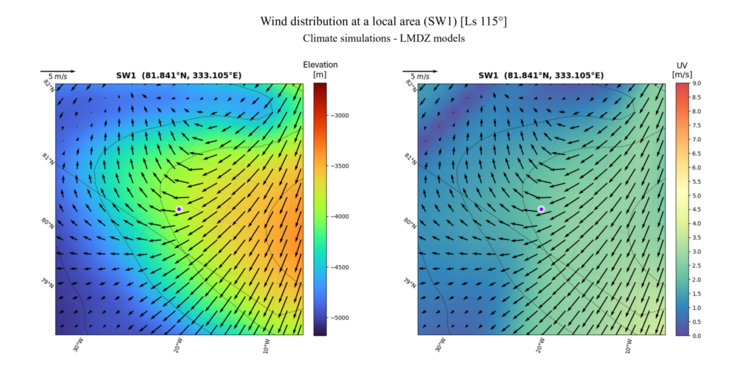
This equation allows measured wavelengths to be converted into equivalent near-surface wind velocities, assuming the observed ridges correspond to the most unstable mode of the sublimation-wave instability. Resulting wavelength, orientation, and wind-velocity maps were compared with LMDZ mesoscale simulations of the MNPC.

Morphological and wavelength analysis: Crest mapping reveals morphological differences between the three study areas. In SW1, ridge networks display junctions and bifurcations but no significant migration between 2008 and 2021. Individual ridges preserve nearly identical shapes and orientations over this 13-year interval, indicating a stable surface pattern. Mean wavelengths remain close to ~7m, consistent with previous measurements of Martian sublimation waves [7]. SW2 and SW3 display shorter wavelengths (~3 m) and local crest displacements between images, although the overall ridge-network geometry remains preserved. Their ridges appear more linear than in SW1 despite the persistence of junctions and bifurcations.
Autocorrelation analyses confirm distinct but internally consistent properties. In SW1, wavelengths range from 6.7 to 7.3 m, corresponding to inferred wind velocities of ~1.9 m s⁻¹ with a dominant WSW–ENE orientation. In SW2, wavelengths remain near 3.6 m, giving wind velocities of ~3.6–3.7 m s⁻¹ and a dominant NW–SE orientation. SW3 displays wavelengths close to 3 m, associated with inferred wind velocities of ~4.3–4.4 m s⁻¹ and a dominant SSW–NNE orientation (Fig. 3).

Comparison with mesoscale climate simulations: Comparison between mesoscale simulations, mapped ridge orientations, and autocorrelation results shows overall consistency, particularly for SW1 (Fig. 4). In this area, both models and autocorrelation indicate a WSW–ENE wind direction, consistent with observed ridge orientations. The absence of significant migration and the ~7 m wavelength further support the sublimation-wave interpretation [7].

For SW2 and SW3, mesoscale simulations and autocorrelation results are consistent in terms of wind velocity and regional wind-direction trends. However, manually mapped ridge orientations do not match the simulated wind field. The ~3 m structures imply winds perpendicular to the mapped crests, whereas simulations suggest winds closer to parallel. This discrepancy may reflect local effects related to topography, slope geometry, or seasonal atmospheric circulation.

Conclusion: The mass balance of the Martian North Polar Cap is controlled by seasonal condensation and sublimation cycles. We focus on the Ls range 90° to 180°, when the seasonal CO₂ frost has sublimated and water-ice sublimation is expected to be most active. In this context, morphometric analysis of metric-scale wavelengths can provide a proxy for identifying areas undergoing net sublimation. Scaling laws for icy sublimation waves also offer a way to constrain near-surface wind direction and velocity from observation.
Among the three investigated areas, SW1 shows the strongest evidence for sublimation-wave formation, with good agreement between observed wavelengths, scaling-law predictions, and mesoscale models. By contrast, SW2 and SW3 show inferred wind directions or velocities that differ from model predictions. This mismatch may reflect local controls by topography, slope geometry, or seasonal circulation, and highlights the need for higher-resolution mesoscale simulations to better resolve near-surface winds.

Acknowledgments: The authors acknowledge support from the French Agence Nationale de la Recherche (ANR), grant ANR-23-CE49-0006 (project SHERPAS).

References:
[1] Brown, A.J. (2016). Icarus, 277, 401–415.
[2] Read, P. (2015). Reports on Progress in Physics, 78, 125901.
[3] Mangold, N. (2011). Geomorphology, 126, 1–17.
[4] Smith, I.B. & Spiga, A. (2018). Icarus, 308.
[5] Herny, C. (2014). Earth Planet. Sci. Lett., 403, 56–66.
[6] Giang Nguyen, T. (2020). Planetary Space Science, 182, 104809.
[7] Bordiec, M. (2020). Earth-Science Reviews, 211, 103350.
[8] Carpy, S. (2023). Frontiers Astron. Space Sci., 10, 1176158.
[9] Bintanja, R. (2001). Journal of Glaciology, 47, 387–396.
[10] Bintanja, R. (1999). Reviews of Geophysics, 37, 337–359.
[11] Moore, J.M. (2017). Icarus, 287, 320–333.
[12] Belissa, V. (2026). This issue.
[13] Andreotti, B. (2009). Nature, 457, 1120–1123. 

How to cite: Cavalié, L., Belissa, V., Carpy, S., and Bertrand, T.: Linking mesoscale atmospheric circulation to icy bedform morphology on the martian north polar cap, Europlanet Science Congress 2026, The Hague, The Netherlands, 7–11 Sep 2026, EPSC2026-334, https://doi.org/10.5194/epsc2026-334, 2026.

09:11–09:23
|
EPSC2026-423
|
On-site presentation
Anna Grau Galofre and Isaac Smith

Introduction: 

The North Polar Layered Deposit (NPDL) is a massive ice deposit located on Mars' north polar region [1,2,3,4]. Radar observations from the SHAllow RADar (SHARAD), reveal a layered internal structure consisting of stratified ice (>95% ) and dust [3], extending to a thickness of 2-3 km. Because of the connection between north polar ice stability and obliquity-modulated climate cycles, the NPLD is a true time capsule of Mars' climate during the NPLD timespan of 4 Myr [5,3,4].

However, the lack of evidence for NPLD flow poses a problem: an ice sheet of this size should actively deform. Previous studies predict ice deformation rates that should be observable [1,6], in stark contrast with the lack of evidence for surface deformation (HiRISE, ~cm/yr). A similar lack of evidence for flow is found by SHARAD, which should record substantial deformation accrued during the NPLD 4  Myr lifetime [7,4].

While numerous studies have investigated NPLD dynamics to understand its flow history and in response to climate changes [7,5,6,4], the question of the lack of observable flow in the NPLD remains unresolved [4]. Here we hypothesize that the lack of accrued NPLD deformation is caused by the rheology of its stiffer layers. We develop and implement a stratified ice flow model coupling vertically variable rheologies derived from ice-dust mixture experiments [10,11], and realistic NPLD stratigraphies from SHARAD. Our results solve the quantitative conundrum by showing that dusty ice layers play a key role preventing NPLD long-term deformation. [4].

Methods:   

We develop a 1D stratified ice flow model with realistic ice and dust mixture rheology, including the experimental observation that dust-ice mixtures become jammed after a threshold dust content (f) of 67%, hence producing rigid layers [10,11]. We model realistic NPLD stratigraphic profiles from SHARAD radargrams [8], and model dust-depth distributions from observations and mass balance modeling [13], deriving layer compositions ranging from pure ice to pure dust.

We address the uncertainty in the parameters and the robustness of the model results with a Monte Carlo approach with over 150 scenarios including `cold' (160 K) and `warm' (172 K) NPLD runs, to retrieve the vertical velocity profile, the maximum and bulk velocities, and the surface deformation rates. We vary the dust distribution with a Bayesian approach, using a Poisson distribution centered around 5% dust, with content increasing with depth.

Model setup. We numerically integrate the Stokes equations for viscous flow at all deformable layers, with a dust-dependent rheology. Velocity is considered continuous across all deformable layers (f < 0.67), whereas a zero velocity condition is applied at the bottom and top of rigid layers with f > 0.67. At the base, the NPLD is assumed to be cold-based, whereas the surface is a free boundary.

Results:

Our results highlight two aspects: (1) Thick, pure ice layers located near the base host the fastest flowing strata of the NPLD. This is a fundamental difference with terrestrial ice sheets, and any type of deformable dome without internal cohesive layers, where the maximum velocity is located at the surface and the maximum deformation occurs at the base. Here the base still hosts the largest strain rates, but cohesive dust-rich layers include equally important deceleration, balancing out the basal velocity gain. Therefore, observations searching for deformation in the NPLD should focus on internal, deep, thick pure ice layers and not on surface motion.

Previous experimental work on martian as well as terrestrial ice-dust mixtures [10,11,12] shows that this flow transition occurs at or near f ~ 0.67. However, the temperature range of these studies is significantly larger from the range of application we consider in this paper, and while the terrestrial studies show that this transition occurs at yet even warmer temperatures, neither these works nor other studies we know of have explored the ductile to brittle transition at temperature and pressure relevant to the NPLD. The details of the rheology of dust-ice mixtures under uniaxial compression, shear, and temperatures relevant to the NPLD is therefore a knowledge gap with the potential to alter our conclusions of NPLD flow dynamics, but for which we cannot mitigate.

Conclusions:

The lack of visible flow on the North Polar Layered Deposits (NPLD), both in observations of the ice margin and ice surface and considering the lack of deformation in the interior layering, via SHARAD radar observations, have long challenged the results of ice flow models that aimed to understand this unique behavior.  This study considers the internal stratified nature of the North Polar Layered Deposits (NPLD) in developing a novel model for layered ice flow, considering the existence of ductile layers with varying dust content as well as the presence of undeformable 'dust-rich' layers with dust fractions over 67%.


 Our results yield consistent ice flow rates of order cm/Myr (figure 2) for most scenarios at a temperature of T = 162 K. We find that the main controls on NPLD deformation rates are the existence and distribution of dust-rich layers, which slow down the bulk flow and introduce locally static layers. The concentration of such layers near the base of the NPLD, where most glacial deformation should occur, dramatically slows down NPLD flow and prevents the surface to deform observably. Our results reconcile for the first time observations and glacial flow modeling, and highlight the importance of considering ice-dust stratification in future martian ice flow models, including beyond the polar regions.

Acknowledgments:

This project has received funding from the European Union H2020 program under MSCA grant agreement MGFR – 101027900, and from the RPL-PULSAR program GELMARS to A.G.G.

How to cite: Grau Galofre, A. and Smith, I.: Stratified ice flow explains the lack of deformation on Mars' North Polar Layered Deposit (NPLD), Europlanet Science Congress 2026, The Hague, The Netherlands, 7–11 Sep 2026, EPSC2026-423, https://doi.org/10.5194/epsc2026-423, 2026.

09:23–09:35
|
EPSC2026-935
|
ECP
|
On-site presentation
Giovanni Munaretto, Silvia Bertoli, Filippo Tusberti, Adriano Tullo, Frances Butcher, Shane Byrne, Anna Grau Galofre, Gabriele Cremonese, Matteo Massironi, Cristina Re, Costanza Rossi, Maurizio Pajola, Alice Lucchetti, and Nicolas Thomas

Introduction

Eskers are elongated sinuous ridges formed by sediment deposition within subglacial channels, generated by meltwater draining beneath or within glaciers [1,2]. Their identification on Mars [3,4,5,6] provides a unique opportunity to investigate the planet’s glacial history and past water availability [3], because they trace specific thermal or climatic events enabled the production of meltwater in the past [3,4,5,6]. Martian eskers have been predominantly identified in the planet’s mid-latitudes, often associated with Amazonian-aged Lobate Debris Aprons (LDAs) which are interpreted as debris-covered glaciers. Key regions include Phlegra Montes [4], Tempe Terra [e.g, 5-8] and NE Hellas [9]. These studies suggest that even during the predominantly cold and arid Amazonian epoch, locally elevated geothermal fluxes (suggested by the presence of tectonic and/or impact structures), combined with strain heating due to ice flow, enabled subglacial melting. Here, we identify three new candidate eskers associated with LDAs in the Deuteronilus Mensae region of Mars. By analyzing their morphology, morphometry, geologic context and cratering record, we aim to test whether they are indeed eskers and discuss their possible formation scenarios.

Data & methods

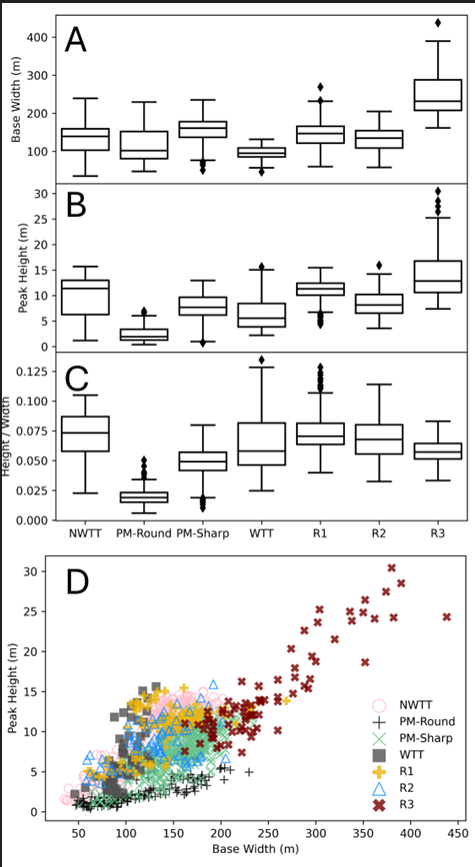
We relied on CTX global mosaics, HiRISE orthophotos and digital terrain models (DTMs), CaSSIS color imagery and DTMs, MOLA topography, and THEMIS nighttime infrared mosaics to examine the ridges and their surrounding geologic contexts. Impact craters were digitized to derive crater size-frequency distributions (CSFDs) and model crater retention ages with Craterstats 2.0 software. Ridge morphometry was quantified by measuring crestline-parallel transects on HiRISE DTMs and detrending each profile from basal topography to estimate ridge height and base width, and comparing the resulting distributions to those published for other Martian eskers [4,6,8]. Thermal properties were assessed qualitatively from THEMIS nighttime infrared mosaics.


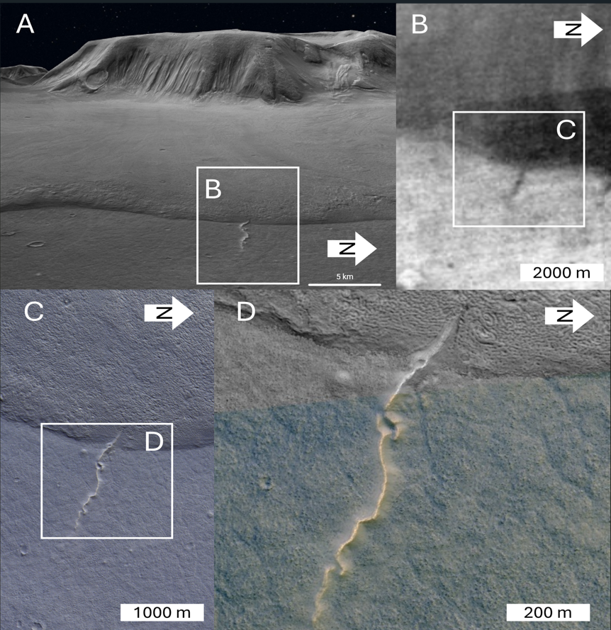
Fig. 1. A) Context 3D view of the R1 ridge from the CTX global mosaic draped over the MOLA DEM B) THEMIS night-time infrared emission map.  C) RGB colour composites from CaSSIS image MY38_032747_042_0. D) HiRISE image ESP_079083_2230.

Results

Three sinuous ridges, (R1, R2, and R3) were identified emerging from the termini of LDAs in Deuteronilus Mensae. An example (R1) is in Fig. 1.  THEMIS observations indicate that R1 and R2 have thermal inertia similar to the LDAs and lower than the surrounding bedrock (Fig. 1C), indicating unconsolidated material rather than indurated sediments.

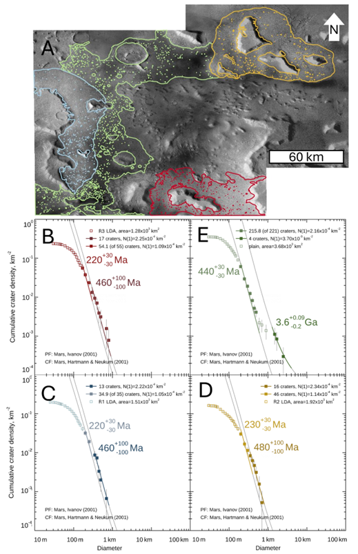
The morphometries of R1 and R2 are consistent with other Martian eskers (Fig. 2C, D), while R3 is somewhat larger but still within the other Martian esker height vs width trends (Fig 2C,D). Crater counting (Fig. 3) indicates a Hesperian-aged plains substrate, and LDA crater retention ages of approximately 460–480 Myr for larger craters and 220–230 Myr for smaller crater populations.

Fig 2. Comparison of ridges base width (A) and peak height (B) and their ratio (C) distributions, shown as box-plots, with the other martian eskers. (Data for North-West TempeTerra (NWTT) are from [8], Phlegra Montes (PM ) from [4] and West Tempe Terra (WTT) from [6]). D) Base width vs Peak height comparison between R1-R3 ridges and the martian eskers

Fig. 3. A) CTX global mosaic showing the crater counting areas (coloured outlines) and the mapped impact craters. Crater CSFDs of the LDAs associated with ridges R1-R3 (panels B-D) and plains units (E).

Discussion & conclusions

A moraine (either terminal, lateral or medial), inverted river [10] and esker hypothesis have been considered to explain the ridges formation. The combined assessment (that will be presented in detail at the conference) of geologic context, morphometric measurements and thermal data suggest that the most plausible interpretation is that R1–R3 are eskers deposited by meltwater flowing within or beneath polythermal glaciers and exposed The study region lacks volcano-tectonic features that might indicate localized geothermal anomalies, making geothermal heating an unlikely primary driver for meltwater production by glaciers. Obliquity-driven climate variations [11, 12] represent a potentially interesting mechanism. Climate modelling indicates that at high obliquities, annual accumulation of snow and ice occurred in the mid-latitudes [13,14] together with increased temperature swings and a more humid atmosphere than the present-day [14,16], providing a qualitatively plausible thermodynamic environment for esker formation.

The discovery of eskers in Deuteronilus Mensae expands the known geographic extent of late Amazonian wet-based or polythermal glaciation on Mars and shows that episodic meltwater drainage occurred in a region previously thought to record mainly cold-based ice activity.

Acknowledgements

CaSSIS is a project of the University of Bern and funded through the Swiss Space Office via ESA’s PRODEX programme. The instrument hardware development was also supported by the Italian Space Agency ASI (ASI-INAF agreement no. 2020-17-HH.0), INAF–Astronomical Observatory of Padova, and the Space Research Center CBK in Warsaw. Support from SGF Budapest, the University of Arizona Lunar and Planetary Lab., and NASA are also gratefully acknowledged. Operations support from the UK Space Agency under grant STR0030251 is also acknowledged. We gratefully acknowledge support from the Italian Space Agency ASI with ASI-INAF agreements n. 2022-8-HH.0 and n. 2024-40-HH.0. AGG kindly acknowledges support from the Région Pays de la Loire under project RPL-GELMARS. FB acknowledges a Royal Society University Research Fellowship.

References

[1] Shreve, R. L. (1985). Geological Society of America Bulletin, 96(5), 639–646. [2] Storrar,et al., (2014). QSR, 105, 1–25. [3] Butcher FEG, et al., (2022) Annals of Glaciology.2022;63(87-89):33-38. [4] Butcher, F.E.G., 2019. Wet-Based Glaciation on Mars (PhD Thesis). The Open University, Milton Keynes, UK. [5] Butcher, F. E. G. et al., (2017). JGR: Planets, 122(12), 2445–2468.  [6] Woodley, S. Z., et al., (2022). Icarus, 386, 115147.  [7] Butcher, F.E.G. et al., (2021), Icarus 357, 114131[8]  Butcher, F. E. G. et al., (2020). EPSL, 542, 116325. [9] Grau Galofre et al., 2024 Icarus420, p.116211 [10] Dickson et al., (2021) Geology, 49(5):504–509. [11] Laskar, J. (2004). Icarus, 170, 2,343-364 [12] Niu, S. et al., (2025) JGR: Planets, 130, e2024JE008883. [13] Madeleine, J. et al., (2009). Icarus, 203(2), 390–405 [14] Madeleine, J. et al (2014). GRL,41, [15] De Haas, T., et al. (2015). Nature Communications, 6, 7543 [16] Naar, J. (2023). Phd Thesis.


How to cite: Munaretto, G., Bertoli, S., Tusberti, F., Tullo, A., Butcher, F., Byrne, S., Grau Galofre, A., Cremonese, G., Massironi, M., Re, C., Rossi, C., Pajola, M., Lucchetti, A., and Thomas, N.: Evidence of recent warm-based glaciation and meltwater drainage from eskers at Deuteronilus Mensae, Mars, Europlanet Science Congress 2026, The Hague, The Netherlands, 7–11 Sep 2026, EPSC2026-935, https://doi.org/10.5194/epsc2026-935, 2026.

09:35–09:47
|
EPSC2026-1204
|
On-site presentation
Luca Guallini, Graziella Caprarelli, Anna Grau Galofre, Stefano Nerozzi, and Roberto Orosei

The Martian poles are covered by Amazonian Polar Layered Deposits (PLD), consisting of water ice and 5–15% dust [1][2][3][4]. While characterized by plan-parallel stratigraphy [5][6], these deposits contain unconformities—erosional surfaces likely caused by obliquity-driven warming [7][8]. Notably, the Southern Polar Layered Deposits (SPLD) exhibit glacial-tectonic structures and englacial folding not found in the north [9][10][11] (X1 for locations). As on the Earth [e.g., 12], these structures suggest ice sheet movement caused by weight distribution and interaction with basal topography.

The presence of unconformities and englacial structures points to a complex Late Amazonian geo-climatic history recorded by the polar deposits. This history is yet to be fully revealed, but it is likely that it would be relevant to understand also the origin of putative liquid brines discovered by the radar sounder MARSIS at the base of the SPLD in Ultimi Scopuli [13][14] (X2 for approximate location).

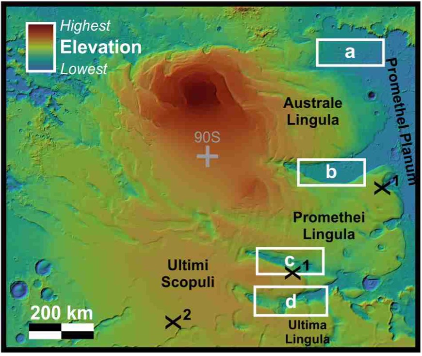
Here we report the preliminary results of our morphological studies of SPLD margins—specifically Ultima, Australe, and Promethei Lingula— (Fig. 1) identifying ridges resembling eskers. These ridges are remnants of subglacial meltwater drainage systems that emplace sediment before ice retreat. While similar features exist in the Argyre Planitia and Dorsa Argentea Formation (early Hesperian) [15][16][17][18], this is the first study to analyze them in direct relation to the SPLD. All this calls for new investigations and insights aimed to revitalize the discussion around the dynamics and potential for subglacial melting of the Southern polar cap glacial body of Mars.

Fig. 1. MOLA context map of the SPLD. White rectangles mark the study areas where the ridges are located. These are shown in detail in Fig. 2.

Dataset: The region has been analyzed using high-resolution visible image (MRO CTX, 6.0 m/pixel; [19]) and THEMIS IR mosaics [20]. Topographic basemaps is from MGS MOLA (512 pixel/degree; 112 m/pixel; [21]); (Fig. 2). 

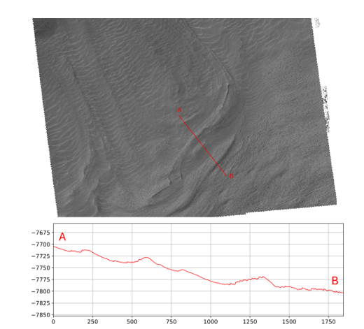
Results:  The ridges (Fig. 2a-f) are particularly evident on the floor of Ultimum (UC) and Promethei Chasmata  (PC) and Chasmata Australe (CA) (Figs. 2b-d) and are deposited on the bedrock exposed between distinct SPLD lingulae. Here the ridges cross the chasmata floors from side to side. In plan-view, these ridges, some tens of km long, appear linear or sinuous and/or branching into Y-shaped junctions. Other two cases (Fig. 2a) are observed in the basal margins of Australe Lingula, extending towards the Promethei Planum (PP) region. This is the best developed system: here the ridges are 100-1000s m wide, up to 10s of m high (Fig. 2e), with both symmetric and asymmetric profiles, more than 100 km long, and presenting multiple order branching. Ubiquitous ice on top of the ridges partially masks or alters the morphometry of the ridges (Fig. 2f). Nevertheless, in the first instance, the crests appear sharp/round or flat and in some cases possibly split in two (or more) parts by troughs (i.e., multi-crested; black arrow in Fig. 2e). Ridges are also locally eroded and cratered.

Fig. 2. White rectangles mark the study areas where the ridges are located. The inboxes magnifications (red circles and black squares) are to highlight example ridges (data from MOLA + THEMIS IR and HRSC). (a-d) MOLA+shaded reliefs of the ridges in PP (a), CA (b), PC and UC (c-d). (e) Example cross-section profile of a ridge. The arrow points to a split crest, possibly evidence of residual ice on top of the ridge or of its pristine morphology. (f) Appearance of the ridges in Promethei Planum in CTX images, likely covered by residual ice. 

Discussion and Conclusions: Analysis of the ridges suggests they are eroded remnants of eskers, supported by their morphology and emergence from the Southern Polar Layered Deposits (SPLD). These features are consistent with terrestrial eskers (Fig. 3; e.g. [21], [22]) and those found in the Martian Dorsa Argentea region. Eskers form when sediment is transported through subglacial drainage systems toward an ice margin; upon retreat, this sediment remains as a ridge. Consequently, their orientation provides a record of past glacial flow and geometry, confirming the necessity of basal melt for their formation. While post-exhumation processes like impact cratering and ice mantling make distinguishing different generations difficult, the presence of fluvio-glacial morphologies would prove that: 1) There was at least one major period of retreat of the Southern ice-sheet; 2) SPLD were significantly more extensive in the past; 3) Alongside englacial folding, that the south polar cap was more dynamic than previously thought, driven by possible melting processes. This opens the door to basal thermal anomalies present through time in this region.

Fig. 3. Example esker in Finland (LiDAR topography; data from National Land Survey of Finland).

References: [1] Herkenhoff K. and Murray B. (1990), doi: 10.1029/JB095iB09p14511; [2] Koutnik M. et al. (2002), doi: 10.1029/2001JE001805; [3] Byrne S. (2009), doi: 10.1146/annurev.earth.031208.100101; [4] Lauro et al. (2022), doi: 10.1038/s41467-022-33389-4; [5]  Tanaka K.L. and Kolb E.J. (2001), doi: 10.1006/icar.2001.6675; [6] Kolb E.J. and Tanaka K.L. (2001), doi: 10.1006/icar.2001.6676; [7] Milkovich S.M. and Plaut J.J. (2008), doi: 10.1029/2007JE002987; [8] Guallini L. et al. (2018), doi: 10.1016/j.icarus.2017.08.030; [9] Smith et al., 2024, doi: 10.1016/j.icarus.2024.116125;[10] Guallini et al. (2012), doi: 10.1016/j.icarus.2012.06.023; [11] Guallini et al. (2025), Abs. 1874, 56th LPSC; [12] Bell et al. (2014), doi: 10.1038/NGEO2179; [13] Orosei et al. (2018), doi: 10.1126/science.aar72; [14] Lauro et al. (2021), doi: doi.org/10.1038/s41550-020-1200-6; [15] Head J.W. (2000), Abs. 1116, 31st LPSC; [16] Head J.W. (2000), Abs. 1117, 31st LPSC; [17] Banks M.E. et al. (2009), doi.org/10.1029/2008JE003244; [18] Tanaka K.L. et al. (2014), Map 3292 USGS; [19] Malin et al. (2007), doi: 10.1029/ 20 06JE0 02808; [20] Christensen et al. (2001), doi: 10.1029/2000JE001370 ; [21] Smith et al. (2001), doi: 10.1029/20 0 0JE0 01364; [22] Shreve R.L. (1985), doi:10.1130/0016-7606(1985)96<639:ECITOG>2.0.CO;2; [23] Huddart D. et al. (1999), doi.org/10.1111/j.1502-3885.1999.tb00219.x.

Acknowledgements: This research was supported by the Next Generation EU program, Mission 4, Component 1, through project “Combining mAchine Learning and optImization for Planetary remote Sensing missiOns” (CALIPSO), Unique Project Code C53D23010010001.

How to cite: Guallini, L., Caprarelli, G., Grau Galofre, A., Nerozzi, S., and Orosei, R.: Esker-Like Ridges In The South Polar Ice-Cap On Mars: Possible Evidence Of Ice Melting, Europlanet Science Congress 2026, The Hague, The Netherlands, 7–11 Sep 2026, EPSC2026-1204, https://doi.org/10.5194/epsc2026-1204, 2026.

09:47–09:59
|
EPSC2026-1015
|
ECP
|
On-site presentation
Elad David, Paul Hayne, and Oded Aharonson

Introduction

The seasonal CO2 cycle on Mars is a key driver of the martian climate system. The cycle affects global energy balance and produces annual pressure variations of ~25% [1] that drive interhemispheric and local airflow [2]. In the southern hemisphere, the seasonal CO2 deposits are particularly enigmatic: ice properties change significantly between different regions; bright and fine-grained ice contrasts with areas of ice that remain dark and cold throughout the sublimation period [3].

Existing studies on the southern seasonal CO2 cycle typically analyzed a few Mars years of data. Here, we analyze nearly two decades of continuous data acquired by the Mars Climate Sounder (MCS) [4], a visible and infrared radiometer onboard the Mars Reconnaissance Orbiter (MRO). While the instrument typically acquires limb observations for atmospheric characterization, high-emission-angle surface observations are regularly obtained. From these, we produce Lambert surface albedo values and explore the regional and temporal variations of ice reflectivity from a multi-annual average and an interannual perspective.

Methods

We use spectral radiance data, computed from band-integrated radiance obtained by the MCS A6 channel (spanning 0.3 - 3 μm), to derive the albedo of the surface CO2 deposits. We retain observations that are associated with surface temperatures below 160 K (brightness temperature at ~32 μm), which include normal frosted regions as well as the Cryptic region [5]. Since the instrument observes the surface at high phase angles (typically between 105° and 145°), radiance is typically elevated, producing non-physical Lambert albedo values. To correct for this, we divide the top-of-atmosphere (TOA) Lambert albedo into 3-degree bins of solar incidence; within each bin, we fit a scaled Henyey-Greenstein phase function. We produce an effective scene (surface + atmosphere) asymmetry parameter (g) versus incidence trend, which we apply to the raw TOA albedo to produce phase-corrected albedo. Next, we apply a delta-Eddington atmospheric correction [6] using MCS-derived aerosol column optical depth to obtain the Lambert surface albedo. We limit our analysis to incidence angles lower than 80°, above which albedo increases rapidly due to instrument noise.

Results

Fig. 1 shows initial mapping results for the southern cap in polar stereographic projection. Prominent features of the southern cap are observed. Due to incidence angle constraints, we can observe the cap only in spring and summer. In mid-spring (Fig. 1a), we observe the cap in sublimation. High-albedo ice is seen in the Mountains of Mitchel (72° S, 330° E), while the Cryptic region (75° S - 85° S, 50° E - 210° E) is notably darker, as expected. Late spring cap (Fig. 1b) is notably asymmetric, with the Cryptic region completely defrosted. Ice remains in the western hemisphere, as well as the outliers at the Mountains of Mitchel. At mid-summer (Fig. 1c), after the sublimation of seasonal frost, the residual cap has a relatively lower albedo.

Fig. 2 presents the multi-annual average CO2 albedo averaged over regions of interest (ROIs). The residual cap (Fig. 2a) is observable starting at Ls ~200°. The cap’s albedo initially fluctuates, and as seasonal ice sublimates to reveal residual ice, the albedo sharply drops to ~0.65. Byrne et al. [7] similarly found darkening during the seasonal frost sublimation. In the Cryptic region (Fig. 2b), ice albedo is initially similar to other regions, and subsequently decreases, showing the “cryptic” behavior presumably caused by slab transparency and/or surface dust accumulation [3]. Around Ls ~210°, a brightening phase is associated with temperatures increasing above the CO2 frost point, before the ice sublimates. 

In both regions, interannual variations are observed. Most prominently, the residual cap appears to have significant interannual albedo variations after Ls ~310°. We also highlight that ice albedo differs somewhat from other literature values (e.g., TES average albedo in the Cryptic region reaches values as low as ~0.2 in early spring, where our value is ~0.5). This may be due to errors in the atmospheric correction or non-Lambertian behavior of the ice.

Conclusions

The long observational baseline of MCS offers a unique opportunity to explore previously documented phenomena over multi-annual timescales and identify interannual variations over nearly a full martian decade. In addition, simultaneous MCS atmospheric and surface IR observations can be used to investigate relationships between visible ice albedo, atmospheric conditions, and ice metamorphic state. We are currently exploring several intriguing findings that could shed light on the seasonal evolution of southern CO2 ice.

References

[1] James, P. B., Kieffer, H. H., & Paige, D. A. (1992). 934-968. [2] Siili, T., Haberle, R. M., & Murphy, J. R. (1997). Advances in Space Research, 19(8), 1241-1244. [3] Kieffer, H. H., Christensen, P. R., & Titus, T. N. (2006). Nature, 442(7104), 793-796. [4] McCleese, D. J., Schofield, J. T., Taylor, F. W., Calcutt, S. B., Foote, M. C., Kass, D. M., ... & Zurek, R. W. (2007). Journal of Geophysical Research: Planets, 112(E5). [5] Kieffer, H. H., Titus, T. N., Mullins, K. F., & Christensen, P. R. (2000). Journal of Geophysical Research: Planets, 105(E4), 9653-9699. [6] Wiscombe, W. J., & Warren, S. G. (1980). Journal of Atmospheric Sciences, 37(12), 2712-2733. [7] Byrne, S., Zuber, M. T., & Neumann, G. A. (2008). Planetary and Space Science, 56(2), 194-211. 

Figure 1: Multi-annual (MY 29-37) average CO2 ice albedo. Data is obtained at ~3 PM local time, binned into 18 x 18 km cells and 15° Ls. Selected time frames include a) seasonal cap recession during mid-spring, b) late spring, and c) residual cap at mid-summer. ROIs shown in Fig. 2 are marked in (a); residual cap in cyan and the Cryptic region in red.


Figure 2: ROI-average CO2 ice albedo for a) the residual cap and b) the Cryptic region. Multi-annual average albedo across MY 29 - 37 with standard error of the ROI mean (SEM).


How to cite: David, E., Hayne, P., and Aharonson, O.: The Seasonal Evolution of Southern CO2 Ice from MCS Observations, Europlanet Science Congress 2026, The Hague, The Netherlands, 7–11 Sep 2026, EPSC2026-1015, https://doi.org/10.5194/epsc2026-1015, 2026.

Orals MON2: Mon, 7 Sep, 11:00–12:26 | Room Neptune (Spinoza Foyer)

Chairpersons: Matteo Teodori, Luca Maggioni, Silvia Bertoli
11:00–11:02
11:02–11:14
|
EPSC2026-190
|
On-site presentation
Petr Broz, Priyanka Biju Sindhu, Vojtěch Patočka, Mark G. Fox-Powell, Frances E. G. Butcher, Matthew Sylvest, and Manish R. Patel

Introduction

Previous experimental studies of effusive cryovolcanism conducted in low-pressure chambers (e.g., [1–3]) have largely focused on the behaviour of liquids that remain effectively “stationary”, or where fluid motion is negligible and can be approximated as laminar. In such setups, the investigated systems typically represent quiescent water bodies, where phase transitions—boiling, freezing, and evaporation—occur without significant prior internal mixing or advective transport. However, this represents a substantial simplification of natural conditions.

On icy world surfaces, effusive cryovolcanic eruptions are expected to produce flows that move downslope under gravity (e.g., [4,5]), potentially transitioning from laminar to turbulent flow regimes [6] depending on discharge rates, slope, and fluid properties. Such flow dynamics are likely to play a critical role in controlling heat transfer, phase stability, and the spatial distribution of freezing and evaporation processes. Turbulent regimes may also be relevant to past liquid water activity on Mars (which currently has a low-pressure atmosphere; [7]), for example where flowing water entered palaeolakes from inlet valleys.

Recent theoretical work by Morrison et al. [6] suggests that flow regime exerts a first-order control on cryolava evolution. In particular, turbulent flow should enhance internal mixing and heat transport, which can delay surface freezing, sustain liquid mobility over longer distances, and should modify the balance between conductive and evaporative cooling. This contrasts with laminar flows, where limited mixing promotes rapid development of insulating crusts and more localized freezing [1,2]. As a result, the transition to turbulence may fundamentally alter both the longevity and morphology of cryovolcanic flows.

Here, we aim to address this knowledge gap by experimentally investigating how different flow regimes influence the behaviour of metastable liquids exposed to low atmospheric pressure. Specifically, we seek to understand how the transition from laminar to turbulent conditions affects boiling dynamics, evaporative cooling, and ice formation in saline and pure water systems under low pressure (>4 mbar) surface conditions.

Methods

We employ a modified experimental setup based on previous studies [2,3], consisting of a transparent 40 × 40 × 40 cm plexiglass tank placed within a low-pressure simulation chamber ‘George’ situated at the Open University (UK). The tank is filled with aqueous solutions spanning a range of salinities, including low-salinity water (0.5 wt%), intermediate salinity (5 wt%), and eutectic compositions representative of MgSO₄ and NaCl brines.

In contrast to earlier experiments, which investigated largely static systems, the newly developed setup is equipped with a pair of counter-facing rotors mounted on opposing vertical walls of the tank. These rotors allow controlled stirring of the fluid, with adjustable rotation speeds enabling systematic variation of the flow regime from weakly mixed (near-laminar) to strongly turbulent conditions.

The evolution of the fluid under decreasing pressure is monitored using a combination of visual imaging (cameras), thermal measurements (thermocouples), mass-loss monitoring using a weighing system, and pressure sensors for improved characterization of the pressure conditions surrounding the evaporating medium, allowing direct comparison of phase transitions and flow behaviour across different dynamical regimes.

Results

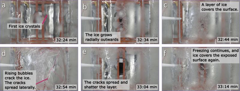
Initial exploratory experiments suggest that fluid motion within the experimental tank exerts a first-order control on the boiling and freezing behaviour of water under low-pressure conditions. In static experiments, where the fluid remains largely quiescent, we consistently observe an initial phase characterized by the development of large macroscopic bubbles, followed by a relative calming of the water surface and the onset of floating ice crystal formation. These ice crystals subsequently and progressively coalesce into a continuous ice cover, which is periodically fractured by escaping water vapour. In contrast, stirred conditions produce a markedly different evolution. At times when static systems have already developed a coherent ice crust, the surface of dynamically mixed systems remains entirely ice-free.

Preliminary observations further indicate that mixing of the water suppresses bubble growth and reduces bubble coalescence. As a result, the formation of large macroscopic bubbles appears to be relatively limited compared to static experiments. Thermal measurements further reveal that, despite temperatures dropping well below the nominal freezing point throughout the fluid column, ice formation is initially suppressed. The liquid thus persists in a metastable state across the entire volume. This state, however, is inherently unstable. Once a critical threshold is reached, the system undergoes a rapid, system-wide transition: crystallization is initiated nearly simultaneously throughout the fluid, resulting in near-instantaneous freezing of the entire volume within seconds.

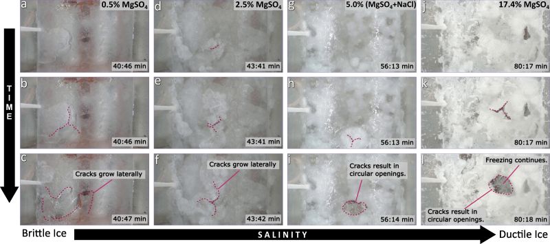
The resulting ice structure appears to be strongly controlled by salinity. Low-salinity experiments produce a coherent and continuous ice layer, whereas higher salinity systems yield a slush-like mixture composed of suspended ice crystals within a residual liquid phase. This remaining liquid is interpreted as a salt-enriched brine, consistent with progressive solute rejection during ice formation. However, these interpretations remain tentative and will require validation through a substantially larger experimental dataset and systematic parameter-space exploration.

Conclusions

These observations are consistent with, and provide experimental support for, the framework proposed by Morrison et al. [6], which predicts that turbulent flow enhances internal mixing and delays surface freezing. The current experiments therefore provide an initial indication that such mixing can prolong metastability and promote abrupt, bulk crystallization once critical conditions are exceeded.

Further experiments are ongoing to systematically quantify the role of flow intensity, salinity, and pressure in controlling these processes. In particular, we aim to constrain the thresholds governing the transition from delayed freezing to rapid crystallization, and to assess the implications for the morphology and longevity of cryovolcanic flows on icy worlds. Future work will also focus on verifying the reproducibility and robustness of the trends identified in these initial exploratory experiments.

References

[1] Brož et al. (2025), Earth Planet. Sci. Lett. 668, 119531  [2] Patočka et al. (2026), Earth Planet. Sci. Lett. 685, 119999  [3] Fox-Powell et al. (2026), EGU abstract 26-21408 [4] Fagents (2003), J. Geophys. Res., 108(E12), 5139 [5] Lesage et al. (2020), Icarus 335, 113369. [6] Morrison et al. (2022), J. Geophys. Res.: Planets 128, E007383, [7] Moreland et al., (2025), AGU Advances, e2025AV001891.

How to cite: Broz, P., Biju Sindhu, P., Patočka, V., Fox-Powell, M. G., Butcher, F. E. G., Sylvest, M., and Patel, M. R.: Experimental investigation of flow regime effects on metastable liquid freezing during cryovolcanic effusive eruptions, Europlanet Science Congress 2026, The Hague, The Netherlands, 7–11 Sep 2026, EPSC2026-190, https://doi.org/10.5194/epsc2026-190, 2026.

11:14–11:26
|
EPSC2026-122
|
ECP
|
On-site presentation
Lucas Lange, Sylvain Piqueux, Paul O.Hayne, Cyril Mergny, Alice Le Gall, Frédéric Schmidt, Julie Rathbun, John Spencer, Kya Sorli, Sarah Howes, Carly Howett, Christopher Edwards, and Phil Christensen

Thermal measurements provide key constraints on the physical properties of icy satellite surfaces, including grain size, porosity, and regolith structure. On the icy moon of Jupiter Europa, previous analyses [e.g., 1,2] of the Galileo Photopolarimeter–Radiometer (PPR) dataset revealed heterogeneities in thermal inertia, but the limited spatial resolution and coverage prevented a detailed characterization of the thermophysical properties of the surface. Yet, the determination of these thermophysical properties is crucial to predict the surface temperatures of Europa that can be used to search for endogenic activity as hot spots, one of the main scientific targets of the upcoming NASA’s Europa Clipper mission [3].

We derived high-resolution maps of Europa’s surface albedo and thermal inertia, and inferred the microphysical properties of its icy regolith, through a reanalysis of the Galileo PPR dataset. We specifically investigated the spatial variability of these properties to discuss the processes controlling the thermophysical evolution of Europa’s surface. To do so, we used the KRC thermal model [4] to analyze the PPR brightness temperatures and retrieve the albedo and thermal inertia that best fit the observations. These values were then interpreted using theoretical conductivity models of porous ice [5] to constrain grain size and porosity and to investigate possible sintering processes affecting the surface.

We will present at the conference our main results: we derived a mean Bond albedo of 0.64 ± 0.06 (standard deviation of 1σ) and a mean thermal inertia of 56 ± 17 J m−2 K−1 s−1/2 (1σ). The thermal inertia shows significant spatial variations, including a band of low thermal inertia at the equator (39 ± 7 J m−2 K−1 s−1/2, 1σ) and higher values (56 ± 11 J m−2 K−1 s−1/2, 1σ) at mid-latitudes on the leading hemisphere (0°–180° W). The equatorial region of the trailing hemisphere (180° W–360° W) also exhibits higher thermal inertia (63 ± 17 J m−2 K−1 s−1/2, 1σ) than the leading hemisphere, likely related to compositional differences. Interpreting the thermal inertia with conductivity models indicates a porous icy regolith with grain sizes ranging from a few micrometers to a few centimeters and an average porosity of 0.61 ± 0.1 (1σ).

Interestingly, the thermal inertia distribution shows little correlation with geological units, the Pwyll ejecta being a notable exception, with markedly higher values than the surrounding terrain. In contrast, the good agreement between the thermal inertia distribution and modeled sputtering rates suggests that sputtering-driven sintering may play a fundamental role in controlling the thermophysical properties of Europa’s surface. The absence of a high thermal inertia equatorial band analogous to the PacMan anomaly observed on Saturn’s icy moons [e.g., 6] indicates that electron-driven sintering is inefficient on Europa, while temperature-gradient metamorphism may instead enhance grain growth at depth, potentially explaining the absence of large grains at the surface. In addition, modeled surface temperatures range from ~67 to 148 K at mid to low latitudes, with peak daytime temperatures counteracting radiolytic amorphization, while limiting the stability of volatile species. During the Europa Clipper mission (2031–2034), temperatures are expected to be slightly lower, ranging between 67.6–141.2 K. Our predictions provide a framework for interpreting future observations by the Europa Thermal Emission Imaging System (E-THEMIS) onboard Europa Clipper and the Submillimetre Wave Instrument (SWI) on JUICE. These future thermal measurements will provide key constraints to test these hypotheses and refine our understanding of the evolution of Europa’s icy regolith as well as search for active hot spots.

Acknowledgements

LL’s research was supported by an appointment to the NASA Postdoctoral Program administered by Oak Ridge Associated Universities at the Jet Propulsion Laboratory, California Institute of Technology, under a contract with the National Aeronautics and Space Administration (80NM0018D0004). Part of this work was performed at the Jet Propulsion Laboratory, California Institute of Technology, under a contract with the National Aeronautics and Space Administration (80NM0018D0004). Some of the computational analyses were run on Northern Arizona University’s Monsoon computing cluster, funded by Arizona’s Technology and Research Initiative Fund. © 2026. All rights reserved.

References

[1] Rathbun et al., 2010, Icarus, 210, 763–769

[2] Rathbun & Spencer, 2020, Icarus, 338, 11350

[3] Pappalardo, R. T., Buratti, B. J., Korth, H., et al. 2024, SSR, 220

[4] Kieffer, H. H. 2013, JGR: Planets, 118, 451–470

[5] Ferrari & Lucas, 2016, A&A, 588, A133

[6] Howett et al., 2011, Icarus, 216, 221–226

How to cite: Lange, L., Piqueux, S., O.Hayne, P., Mergny, C., Le Gall, A., Schmidt, F., Rathbun, J., Spencer, J., Sorli, K., Howes, S., Howett, C., Edwards, C., and Christensen, P.: Thermophysical Properties of Europa’s Surface Constrained by Galileo Photopolarimeter-Radiometer Temperature Measurements, Europlanet Science Congress 2026, The Hague, The Netherlands, 7–11 Sep 2026, EPSC2026-122, https://doi.org/10.5194/epsc2026-122, 2026.

11:26–11:38
|
EPSC2026-1181
|
On-site presentation
Gabriele Turchetti, Flavia Cimbolli Spagnesi, Elena Pettinelli, Sebastian Lauro, Barbara Cosciotti, and Elisabetta Mattei

The JUICE and Europa Clipper missions, both directed toward the Jovian system, carry among their instrument suites two radar sounders, RIME [1] and REASON [2], respectively, designed to probe the subsurface structure of Jovian icy moons.

Europa, Ganymede and Callisto ice shells shallow portion are composed by water ice, predominantly in the form of polycrystalline Ih. It is expected that such ice is contaminated by different chemical species [3][4][5] that might or might not affect the penetration of the signal emitted by a radar sounder. Pure water ice Ih, is highly transparent to radio waves especially at the cold temperatures of these moons. The parameter controlling the wave/ice interaction is the complex dielectric permittivity, which is both temperature and frequency dependent and follows a typical Debye-like behaviour up to several hundreds of MHz.

At the microscopic scale, ice dielectric properties are related to the motion of the protonic point defects which generate both polarization and conduction phenomena, although a unified understanding of the physical mechanisms underlying such properties is not available yet [6][7][8]. Measuring such properties in pure water ice is not trivial and it is difficult to reproduce, because sample preparation and laboratory procedure have a strong impact on the results. Conflicting or incompatible experimental data arise from microscopic and macroscopic differences in the ice samples, such as: specific crystal orientations, dislocations, cracks and fractures, gas bubbles and inclusions, chemical impurities, vacancies and other lattice imperfections [9][10][11]. In this work we discuss the results obtained in different conditions by various authors [12][13][14] and we present some results obtained in our laboratory using different procedures and temperature gradients.

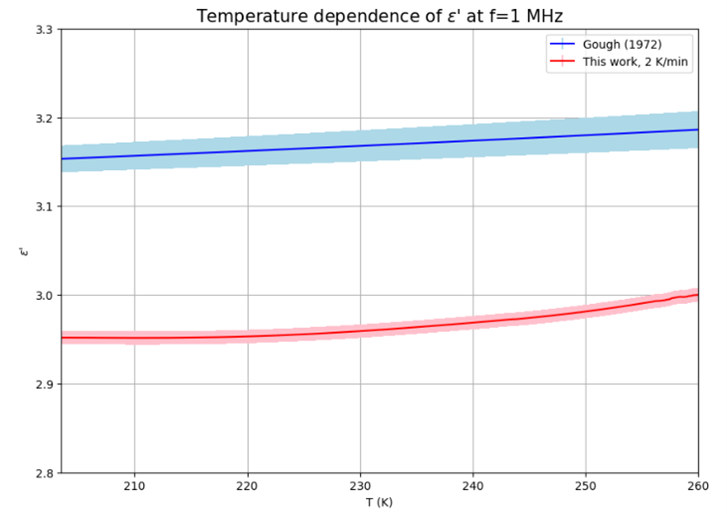
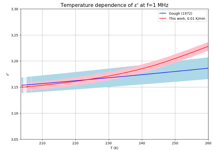
Our laboratory setup comprises various instruments (ultra-freezer and climatic chamber) dedicated to controlling the temperature and temperature gradient at which ice is grown, as well as instruments for measuring the dielectric properties (LCR meter and Vector Network Analyzer). As an example, we present the evolution of the real part of the permittivity of two ice samples grown at different temperature rates, measured with an LCR meter at the frequency of 1 MHz (Fig. 1 and Fig. 2) . Our results are compared, in both cases, with those reported in [15]. The cooling rate is seen to have a significant effect on the measured real part of dielectric permittivity.  Understanding the factors that influence the dielectric properties of ice is of  great importance for the correct interpretation of future radar data.

Bibliografia

[1] Bruzzone L. et al. (2013) In: IEEE international geoscience and remote sensing symposium-IGARSS.

[2] Blankenship D. et al. (2018) In: 42nd cospar scientific assembly 42: B5-3 

[3] SK Sharma et al. Standoff Raman spectroscopy for future Europa Lander missions. 2020.

[4] Trumbo, S. K. Science advances 5.6 (2019): eaaw7123. 

[5] Pettinelli E., Cosciotti B., Di Paolo F., Lauro S.E., Mattei E., Orosei R., Vannaroni G., Dielectric properties of Jovian satellite ice analogs for subsurface radar exploration: A review, Reviews of Geophysics, 53, 593-641 (2015).

[6] Bjerrum N., Structure and properties of ice, Science, 115, 385-390 (1952)

[7] Petrenko V.F., Whitworth R. W., Physics of Ice, Oxford University Press (2002).

[8] Eigen M., De Maeyer L., Self-dissociation and protonic charge transport in water and ice, Proc. Roy. Soc. Lond., A 247, 505-533 (1958).

[9] Carte A. E., Air Bubbles in Ice, Proc. Phys. Soc., 77, 757-768 (1961).

[10] Murdza A., Schulson E., Renshaw C., Polojärvi A. Rapid Healing of Thermal Cracks in Ice, Geophysical Research Letters, 49, 10.1029/2022GL099771 (2022).

[11] Sasaki K., Kita R., Shinyashiki N., and Yagihara S., Dielectric Relaxation Time of Ice-Ih with Different Preparation, The Journal of Physical Chemistry B, 120, 16, 3950-3953 (2016).

[12] Kawada S., Dielectric Anisotropy in Ice Ih, Journal of The Physical Society of Japan, 44, 6,1881-1886 (1978).

[13] Auty R. P., Cole R. H., Dielectric Properties of Ice and Solid D2O, J. Chem. Phys., 20, 1309-1314 (1952).

[14] Johari G.P., Whalley E., The Orientation Polarization in Hexagonal Ice Parallel and Perpendicular to the c-axis, J. Chem. Phys, 75, 1333 (1981).

[15] Gough S.R., A Low Temperature Dielectric Cell and the Permittivity of Hexag- onal Ice to 2 K, Canadian Journal of Chemistry, 50, 3046-3051 (1972).

Figure 1 Real part of dielectric permittivity ε’ as a function of the temperature. The red data correspond to a sample grown at a cooling rate of 0.01 K/min, blue data have been obtained by [15].


Figure 2 Real part of dielectric permittivity ε’ as a function of the temperature. The red data correspond to a sample grown at a cooling rate of 2 K/min, blue data have been obtained by [15].

How to cite: Turchetti, G., Cimbolli Spagnesi, F., Pettinelli, E., Lauro, S., Cosciotti, B., and Mattei, E.: Re-visiting the dielectric properties of pure water ice in the framework of the SWIM project to assess radio waves penetration in the Galilean icy moons, Europlanet Science Congress 2026, The Hague, The Netherlands, 7–11 Sep 2026, EPSC2026-1181, https://doi.org/10.5194/epsc2026-1181, 2026.

11:38–11:50
|
EPSC2026-238
|
ECP
|
On-site presentation
Mariana Reis, Erika Kaufmann, and Axel Hagermann

Icy moons such as Europa and Enceladus are known for their icy outer shells and liquid subsurface oceans that may be habitable [1,2,3]. Salt-bearing ice has been detected on their surfaces and is thought to have originated from these salty subsurface oceans. Sodium salts [4,5], and more recently phosphate salts [6], have been proposed as components of Enceladus’ surface and ocean. However, the effects of salt contamination on the surface evolution of icy moons under space-like conditions remain poorly constrained. We do not know how different salts influence the microstructural and mechanical evolution of icy moon surfaces. With ongoing and upcoming missions to icy worlds, it is important to have experimental analogue work to accompany the interpretation of data from these missions and help define mission design needs.

We experimentally investigate how salt contamination affects the microstructural and mechanical evolution of granular ice under Enceladus-like surface conditions. We prepare granular ice intra-mixtures of water and salts, and irradiate them in a pre-cooled vacuum chamber to examine how they evolve over time. The study includes monitoring temperature evolution during the simulation, pre- and post-exposure microstructural imaging and reflectance spectroscopy, and obtaining the depth-dependent mechanical strength profile of the samples after simulation. We found that surface evolution is highly dependent on salt type. All salt-bearing samples formed a crust, supported by their spectral changes and strength measurements, but had distinct depth-dependent strength profiles. Surface cracking was observed in some salt samples and appears to depend on salt type. This implies that salt-rich regions on icy moons may develop different mechanical properties and morphologies, depending on the dominant salt species present. Therefore, constraining salt type may be crucial for explaining surface evolution as well as for future lander missions, as near-surface consolidation and mechanical behavior seem to depend on salt type.


References:

[1] Porco, C. C., Helfenstein, P., Thomas, P. C., Ingersoll, A. P., Wisdom, J., West, R., ... & Squyres, S. (2006). Cassini observes the active south pole of Enceladus. science, 311(5766), 1393-1401.

[2] Kempe, S., & Kazmierczak, J. (2002). Biogenesis and early life on Earth and Europa: favored by an alkaline ocean?. Astrobiology, 2(1), 123-130.

[3] McKay, C. P., Porco, C. C., Altheide, T., Davis, W. L., & Kral, T. A. (2008). The possible origin and persistence of life on Enceladus and detection of biomarkers in the plume. Astrobiology, 8(5), 909-919.

[4] Postberg, F., Kempf, S., Schmidt, J., Brilliantov, N., Beinsen, A., Abel, B., ... & Srama, R. (2009). Sodium salts in E-ring ice grains from an ocean below the surface of Enceladus. Nature, 459(7250), 1098-1101.

[5] Postberg, F., Schmidt, J., Hillier, J., Kempf, S., & Srama, R. (2011). A salt-water reservoir as the source of a compositionally stratified plume on Enceladus. Nature, 474(7353), 620-622.

[6] Postberg, F., Sekine, Y., Klenner, F., Glein, C. R., Zou, Z., Abel, B., ... & Tan, S. (2023). Detection of phosphates originating from Enceladus’s ocean. Nature, 618(7965), 489-493.

How to cite: Reis, M., Kaufmann, E., and Hagermann, A.: The impact of salt on the microstructural and mechanical evolution of granular ice under Enceladus-like conditions, Europlanet Science Congress 2026, The Hague, The Netherlands, 7–11 Sep 2026, EPSC2026-238, https://doi.org/10.5194/epsc2026-238, 2026.

11:50–12:02
|
EPSC2026-200
|
On-site presentation
Rosario Brunetto, Noemi Pinilla-Alonso, John Stansberry, Sasha Cryan, William Grundy, Aurélie Guilbert-Lepoutre, Joshua Emery, Elsa Hénault, Bryan Holler, Javier Licandro, Larissa Markwardt, Léa Bouvet, Brittany Harvison, Tania Le Pivert-Jolivet, Eva Lilly, Hsing-Wen Lin, Vania Lorenzi, Lucas McClure, Alessandro Morbidelli, and David Nesvorny and the DiSCo-TNOs & GTO-KBOs teams

Trans-Neptunian objects (TNOs), Centaurs, and Neptune Trojans are relatively pristine remnants of the original Solar System planetesimals and therefore can inform us on planetary formation and evolution processes in the cold regions of our protoplanetary disk. Since 2022, using the James Webb Space Telescope's NIRSpec instrument, different observational programs have obtained near-infrared spectra (0.7-5.0 µm) of over one hundred medium-sized bodies (20-1000 km) from these populations, assembling the largest and most compositionally diverse spectral dataset of icy outer Solar System objects to date.

Our analysis of this large sample of objects confirms the existence of compositional categories identified by DiSCo-TNOs [1,2], mainly defined by absorption features of H2O, CO2, CH3OH, CO and OCN- ices, and other complex organic materials. The different dynamical classes (Resonant, Scattering, Detached, Centaurs, etc.) each show a mixture of compositional categories. In contrast, the Cold Classical TNOs, thought to still be on their formational low-inclination, low-eccentricity orbits in the outer disk, nearly all exhibit a single spectral category dominated by organics and N-bearing materials (DiSCo Cliff2 TNOs) [3,4], consistent with their distinct dynamical and collisional history.

Our observations highlight an outstanding trend seen in the CO2 ice abundance across the population. While all targets show some level of CO2, CO2-rich objects are almost absent at perihelion distances smaller than ~31 AU, and CO2 band areas tend to correlate with the true-anomaly-averaged solar flux. The boundary between CO2-rich and CO2-poor objects in perihelion-diameter space follows a diagonal trend, pointing to a coupled thermal and gravitational control of CO2 retention: bodies that are either too small or too warm tend to lose their CO2 to space, while larger, colder objects can retain a segregated CO2 layer. Furthermore, we performed laboratory ion irradiation experiments and we observed that a thin (~5-20 µm) and irradiated CO2 layer over CH3OH/organic substrates can reproduce the spectral features of CO2-type TNOs. In contrast, objects where CO2 is trapped within H2O or CH3OH matrices show a more gradual depletion with no sharp transition.

Taken together, the observed surface compositions reflect evolutionary processing superimposed on primordial compositional categories. Sharp transitions between spectral categories point to early sculpting by ancient icelines, such as a pre-accretional CO iceline or post-accretional CO2 and CH3OH retention icelines, probably established before planetary migration. Organics-type TNOs likely represent a cold primordial population that retains the closest link to the composition of materials in the outer regions of the protoplanetary disk.

These results provide new information on the distribution of ices in the outer Solar System, the processes governing volatile retention and loss on icy bodies, and the chemical gradients established during the earliest stages of Solar System formation.

1.    Pinilla-Alonso, N., et al., Nat Astron 9, 230–244 (2025)
2.    Brunetto, R., et al., APJL, 982:L8 (2025)
3.    McClure, L.T., et al., AJ, 171:54 (2026)
4.    Cryan, S., et al., APJ, 993:188 (2025)


How to cite: Brunetto, R., Pinilla-Alonso, N., Stansberry, J., Cryan, S., Grundy, W., Guilbert-Lepoutre, A., Emery, J., Hénault, E., Holler, B., Licandro, J., Markwardt, L., Bouvet, L., Harvison, B., Le Pivert-Jolivet, T., Lilly, E., Lin, H.-W., Lorenzi, V., McClure, L., Morbidelli, A., and Nesvorny, D. and the DiSCo-TNOs & GTO-KBOs teams: Detection, Composition and Distribution of Ices on Outer Solar System Planetesimals by JWST, Europlanet Science Congress 2026, The Hague, The Netherlands, 7–11 Sep 2026, EPSC2026-200, https://doi.org/10.5194/epsc2026-200, 2026.

12:02–12:14
|
EPSC2026-263
|
ECP
|
On-site presentation
Victor Belissa, Sabrina Carpy, and Tanguy Bertrand

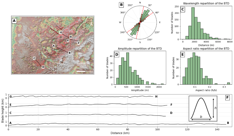
Introduction: The 2015 New Horizons flyby revealed Pluto as a geologically diverse and active world, shaped by complex interactions between volatile ices, topography, and a tenuous atmosphere [1,2]. Among its most enigmatic landforms are the Bladed Terrain Deposits (BTDs) of Tartarus Dorsa, methane-rich ridges forming dense, quasi-periodic patterns with kilometer-scale spacing (Fig 1) [3,4]. Since their discovery, their origin has remained debated. Proposed mechanisms include, tectonic origin,  atmospheric methane condensation, and penitente-like sublimation erosion driven by solar illumination [3,5]. Here, we investigate the formation of BTDs as large-scale icy sublimation waves. Sublimation waves are periodic bedforms produced by feedbacks between wind-driven atmospheric transport and sublimation of an icy substrate [6,7]. They have been observed in Antarctic blue-ice areas and on the Martian north polar cap [8,9]. Recent theoretical studies established scaling laws linking wavelength, wind velocity, growth timescale, and migration speed to environmental conditions [6,7].
In this study, we combine morphometric analysis of the BTDs, linear stability theory, and Pluto-relevant scaling laws to test whether the blades of Tartarus Dorsa can be interpreted as CH₄ sublimation waves.

Methods: 

We performed a morphometric analysis of the BTDs using New Horizons mosaics and DEMs (300m/px) [2,10]. Crestlines were manually mapped across the best-resolved part of Tartarus Dorsa to extract orientation, wavelength, amplitude, asymmetry, and aspect ratio from topographic profiles and 250 representative blades. These measurements were used to characterize the morphology of the blades and compare them with known sublimation-driven bedforms.

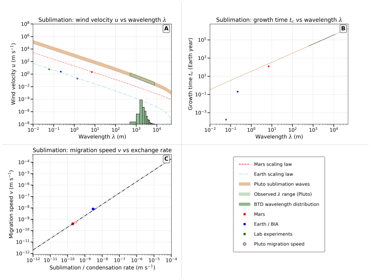
To test the physical plausibility of sublimation-wave formation on Pluto, we used a model coupling turbulent airflow and sublimation under Pluto conditions [6,7]. Pluto-relevant Schmidt numbers, based on CH₄ diffusivity and N₂ viscosity [11–13], were combined with scaling laws to convert observed wavelengths into wind velocity, growth timescale, and migration speed, and to evaluate whether these conditions are compatible with Pluto’s climate.

Morphometric analysis of Tartarus Dorsa blades: 

The BTDs form coherent fields of parallel ridges and troughs, mainly oriented southwest–northeast. Most blades have azimuths of ~32° (Fig. 2). Crest-to-crest spacing is dominated by wavelengths of ~2–3 km. Topographic profiles show broad, asymmetric ridges and a mean aspect ratio of 10%.
These properties differ from penitente-like landforms, which are typically sharp, more symmetrical, and have aspect ratios close to one [5,14–16]. Instead, the low aspect ratio, asymmetry, regular spacing, and coherent orientation of the BTDs are more consistent with sublimation-driven bedforms observed in Antarctic blue-ice areas and proposed on Mars [6–9].

Sublimation-wave emergence under Pluto conditions: Sublimation waves form when spatial variations in sublimation flux become shifted relative to surface topography. If the maximum mass flux occurs at the appropriate position with respect to crests and troughs, relief is amplified rather than smoothed. This feedback depends on the balance between turbulent momentum transport and molecular diffusion [6,7]. For Pluto, expected values of CH₄ diffusivity in N₂ and N₂ kinematic viscosity give Sc ≈ 0.4–1.2 [11–13]. This range lies well within the unstable regime, where growth rates are positive and sublimation waves can spontaneously develop.
This result demonstrates that, despite Pluto’s low atmospheric pressure, the CH₄–N₂ system is physically capable of producing sublimation-driven bedforms under present-day or past Pluto-like conditions.

Scaling laws and implications for Pluto winds: Applying sublimation-wave scaling laws to the observed BTD wavelengths allows us to estimate the wind velocities required to generate kilometer-scale patterns [6,7]. For the measured wavelength of ~2 km, the inferred wind speeds at ~10 m above the surface are on the order of ~1 m s⁻¹. These values are consistent with Pluto global climate model predictions, which show that near-surface winds can locally reach similar magnitudes, particularly in regions affected by topographic gradients and katabatic flows near Tartarus Dorsa [17,18].  
The scaling laws also constrain the formation timescales of the BTDs. For λ ≈ 2 km, predicted growth times are approximately 10⁵–10⁶ years, much shorter than the estimated 10–100 Myr age of Pluto’s methane-rich terrains [20]. Predicted migration speeds are low, around 0.03–1 cm yr⁻¹, implying limited lateral displacement over geological timescales. The blades may therefore represent long-lived erosional landforms, formed early and preserved through repeated climatic cycles [21].

Conclusion: Our results support the interpretation of the Tartarus Dorsa BTDs as large-scale CH₄ sublimation waves. Their wavelength, asymmetry, low aspect ratio, and coherent orientation match the expected morphology of sublimation-driven bedforms and differ from penitente-like structures. Linear stability analysis shows that Pluto’s CH₄–N₂ system lies within the unstable regime for sublimation-wave formation, and scaling laws indicate that the required wind speeds are compatible with Pluto climate models.
The BTDs could therefore be interpreted as erosional landforms produced by wind-enhanced sublimation. This interpretation provides a new framework for using Pluto’s icy bedforms as geomorphic markers of surface–atmosphere interactions and opens the possibility of constraining past and present wind regimes on volatile-rich planetary surfaces. More broadly, this work extends sublimation-wave theory from Earth and Mars to the outer Solar System [22].

Acknowledgments: The authors acknowledge the support of the French Agence Nationale de la Recherche (ANR), under grant ANR-23-CE49-0006 (project SHERPAS).

References

[1] Stern. (2015). Science, 350, aad1815.
[2] Moore. (2016). Science, 351, aad7055.
[3] Moore. (2018). Icarus, 300, 129–144.
[4] Singer. (2025). arXiv, 2506.00254.
[5] Moores. (2017). Nature, 541, 188–190.
[6] Bordiec. (2020). Earth-Science Reviews, 211, 103350.
[7] Carpy. (2023). Frontiers in Astronomy and Space Sciences, 10, 1176158.
[8] Bintanja. (2001). Journal of Glaciology, 47, 387–396.
[9] Bintanja. (1999). Reviews of Geophysics, 37, 337–359.
[10] Schenk. (2018). Icarus, 314, 400–433.
[11] Young. (2018). Icarus, 300, 174–199.
[12] Bordiec. (2020). PhD thesis, Nantes.
[13] Gunn. (2022). Nature Astronomy, 6, 923–929.
[14] Claudin. (2015). Physical Review E, 92, 033015.
[15] Matthes. (1934). Transactions of the American Geophysical Union, 15, 380.
[16] Betterton. (2001). Physical Review E, 63, 1–12.
[17] Bertrand. (2020). Journal of Geophysical Research: Planets, 125, e2019JE006120.
[18] Forget. (2017). Icarus, 287, 54–71.
[19] Gladstone. (2016). Science, 351, aad8866.
[20] Howard. (2017). Icarus, 293, 218–230.
[21] Bertrand. (2024). PNAS, 121, e2408226121.
[22] Cavalie L. (2026). This issue


How to cite: Belissa, V., Carpy, S., and Bertrand, T.: Icy sublimation waves as the origin of the bladed shape of the ch₄-rich terrain deposits of tartarus dorsa on pluto , Europlanet Science Congress 2026, The Hague, The Netherlands, 7–11 Sep 2026, EPSC2026-263, https://doi.org/10.5194/epsc2026-263, 2026.

12:14–12:26
|
EPSC2026-1035
|
ECP
|
On-site presentation
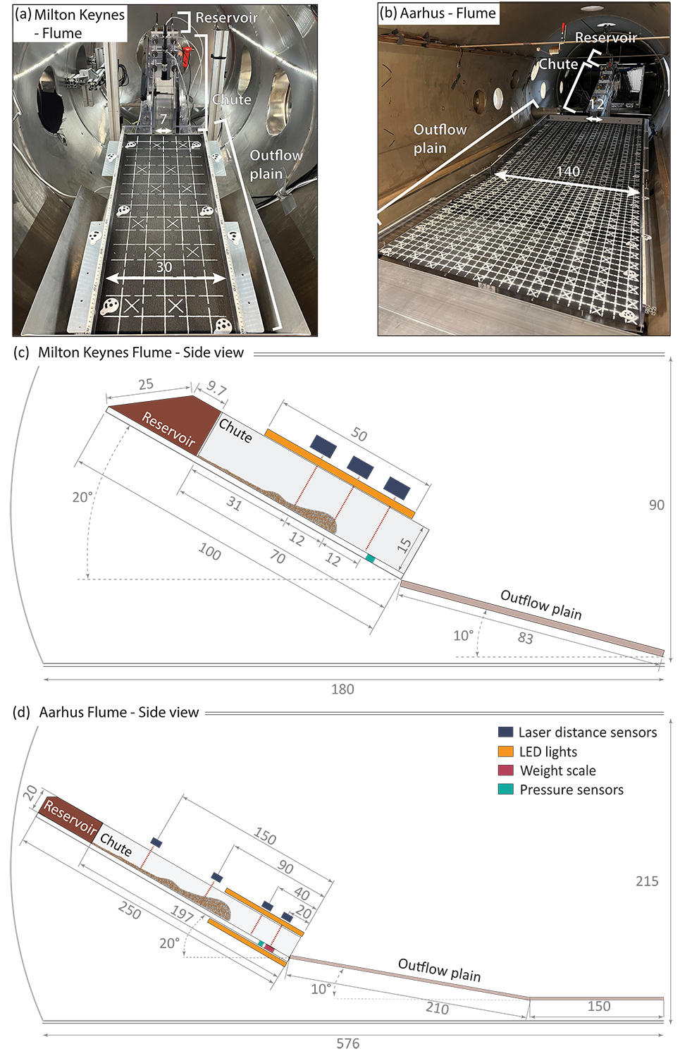
Sharon Diamant, Susan Conway, Lonneke Roelofs, Matthew Sylvest, Zoe Emerland, Jonathan Merrison, Jens Jacob Iverson, Maarten Kleinhans, Jim McElwaine, Manish Patel, and Tjalling de Haas

Introduction
The surfaces of terrestrial bodies are continuously modified by erosional processes throughout the Solar System (Crosta et al. (2018); Conway (2022)). Among these, mass wasting transports loose material downslope under gravity, forming slides, avalanches or flows depending on conditions (Hungr et al. (2014)). How these landforms are formed, and the potential involvement of volatiles, have been widely debated for decades. Current understanding of extraterrestrial mass wasting is mainly derived from Earth analogues; however, these are predominantly shaped by liquid water, which is generally unstable on other planetary surfaces. Yet, numerous extraterrestrial landforms occur where (seasonal) ice or frost is present, and on slopes too gentle for dry material to move by itself. Ice sublimation (solid- gas transition) may drive extra-terrestrial mass wasting by mobilising sediment and reducing friction between particles (de Haas et al. (2019); Roelofs et al. (2024)). However, the effects of sublimation and environmental conditions (e.g., ambient pressure and gravity) on flow behaviour remain poorly understood. This limits our ability to recognise mass-wasting landforms formed by ice sublimation. Here we study the roles of volatiles and environmental conditions, such as ambient pressure and reduced gravity, on the mobility, behaviour, dynamics and deposit morphology of sublimation-driven mass wasting using laboratory experiments in low-pressure chambers.

Methods
Over the past two years, we generated flows driven by sublimating CO2 and H2O ice using two flume set-ups in low-pressure chambers at the Open University and Aarhus University (Figure 1a-b). The flumes consisted of (i) a reservoir containing the material to be released via remote control, (ii) a chute through which the flow travelled, and (iii) an outflow plane onto which the material was deposited (Figure 1c-d) (Roelofs et al. (2024)). The chute was used to measure flow velocity, depth, weight and pore pressure, while the outflow plane allowed examination of the deposit morphology and runout. Ambient pressure ranged from 0.1 to 1000 mbar to simulate pressures on multiple planetary bodies. To assess the effect of different gravities, the mass flows, released from a reservoir at the top of a chute, consisted of ice mixed with either high-density (sand) or low-density granular material (hollow glass beads or nutshells). Because gravitational acceleration and density have the same effect on the force needed to lift the flowing sediment, we utilise low-density sediments to simulate low-gravity bodies.

Results and Discussion
The sublimation-driven granular flows became increasingly fluidised at decreasing ambient pressures for both ice species. Lower pressures increased gas volume flux, reducing the internal particle friction, which enhanced the runout length and flow mobility. This effect was more pronounced in low-density flows (Figure 2), suggesting that sublimation-driven granular flows are likely more mobile on low gravity bodies. The flows also changed behaviour through the sediment density and pressure range, producing transitions across distinct behavioural fluidisation regimes consistent with fluidised bed theory and pyroclastic density currents on Earth (Breard and Lube (2017)).

To analyse the internal particle dynamics of these flow regimes in detail, particle image velocimetry (PIV) was applied to compute the velocity and granular temperature profiles across the flow depth. Figure 4 displays the velocity profiles of the horizontal velocity component of the hollow glass beads at four distinct ambient pressures. The other sediments exhibited similar profiles; for conciseness, the shapes of the velocity and granular temperature profiles are summarised by fluidisation regime in Figure 5. At higher pressures (> 20 mbar), the flows remained in the steady minimum fluidisation regime, characterised by coherent motion and limited particle diffusion (Figure 5a). Between 20 and 1 mbar, bubbles developed within expanded pore spaces, producing shearing and deformation in the basal layers, whereas the upper layers travelled more coherently (Figure 5b). At lower pressures within this range, larger bubble structures known as slugs developed, causing surges and outbursts that temporarily separated the upper layers from the basal layers before settling back into the bulk flow (Figure 5c). Below 1 mbar, a turbulent regime emerged, with a diffuse particle suspension which travelled above a dense, shearing layer. Our analysis concludes that the velocity profile shapes vary systematically across the investigated pressure range, coinciding with transitions between distinct fluidisation regimes, acting as a regime identifier.

In short, sublimation of CO2 and H2O ice can drive mass wasting on bodies with low ambient pressures and low gravity. Distinct fluidisation regimes occur depending on local pressure, gravity and sediment density, affecting deposit shape and size, which might help identify landforms formed by ice sublimation.


Figure 1: The debris flow flumes in (a) the Dirty Mars chamber at the Open University (UK) and (b) the Aarhus Wind Tunnel Simulator at Aarhus University (DK). (c-d) display the side views of the flume composed of a reservoir, chute and outflow plain, including the instruments. The measurements are in centimetres.


Figure 2: Deposit runout (a-b) and frontal flow velocity (c) of CO2 (orange) and H2O (blue) ices over ambient pressure.


Figure 3: High-speed camera screenshots of the flows showing the surges throughout the flows of each ice and hollow glass beads at four ambient pressures. Similar regimes are observed for the other sediments, although they occur at different pressure onsets.


Figure 4: The horizontal (parallel flow) velocity profiles plotted against the flow height for the hollow glass beads at four distinct pressures. The other sediments displayed similar profile shapes. The entire flow is divided into three profile categories: the head, surge(s) and tail of the flow. The solid-coloured profiles represent the flow, whereas the more transparent profiles are the suspended particles atop the flow.


Figure 5: Fluidisation regimes with their associated velocity and granular temperature profiles (a) Minimum fluidization; granular material is sufficiently fluidised to travel downslope. (b) Bubbling fluidization; bubbles develop inside the flow. (c) Slugging regime; bubbles coalescence into larger bubbles and escape the flows through gas outbursts. (d) Turbulent fluidization: consists of a dense bottom layer and a diffuse upper particle cloud.

How to cite: Diamant, S., Conway, S., Roelofs, L., Sylvest, M., Emerland, Z., Merrison, J., Iverson, J. J., Kleinhans, M., McElwaine, J., Patel, M., and de Haas, T.: How Ice Sublimation Drives Extraterrestrial Mass Flows: Dynamics and Environmental Controls, Europlanet Science Congress 2026, The Hague, The Netherlands, 7–11 Sep 2026, EPSC2026-1035, https://doi.org/10.5194/epsc2026-1035, 2026.

Posters: Mon, 7 Sep, 18:00–19:30 | Foyer 2

Display time: Mon, 7 Sep, 08:30–19:30
Chairpersons: Silvia Bertoli, Nicole Costa, Giovanni Munaretto
F2.25
|
EPSC2026-976
|
On-site presentation
jakub morawski, sabrina carpy, paul bessin, olivier bourgeois, clemence herny, stephane pochat, victor belissa, and tanguy bertrand

Introduction 

In East Antarctica, local surface mass balance is strongly modulated by wind-driven erosion, sublimation, and snow or condensation redistribution processes. Persistent katabatic winds drive the formation of extensive parallel and alternating ridges and troughs that stand, respectively, above and below the regional ice-sheet surface. They present distinctive surface topography and associated spatial variations in snow accumulation [1,2]. They are flat bedforms with typical amplitudes of a few meters, wavelengths of several kilometers, and lengths of tens to hundreds of kilometers [2-5]. These bedforms are the so-called megadunes, which are sedimentary bedforms that migrate upwind [2-8]. Similar bedforms have been also described on the North Polar Cap of Mars [7].

On Earth as well on Mars, they represent geomorphic imprints of katabatic dynamics and snow redistribution process. These bedforms influence the spatial and temporal patterns of mass and heat exchanges within the ice sheet [3-4], in the overlying atmosphere and across the ice-atmosphere interface due to aerodynamic and mass transfer feedbacks. Consequently, their existence might introduce non-climatic signals in the stratigraphic and isotopic record retrieved from ice cores [12]. In addition, spatial variations in topography, texture and metamorphism associated with megadunes can modify the surface radiometric properties, thereby affecting reflection and absorption of solar radiation and surface heat exchanges [7-8]. Variations in topography and aerodynamic roughness also influence the structure and dynamics of the overlying atmospheric boundary layer [6]. A comprehensive characterisation of megadune spatial organisation, size, surface shape, texture, internal architecture, composition, dynamics, and formation conditions is therefore essential for accurately quantifying mass and heat transfers within ice sheets, in the overlying atmosphere, and across their interface.

Methods

To provide maps of megadune fields only, and enable their morphometric analyses, our mapping protocol is based on their characteristic undulating surface shape. This shape may be defined geometrically as a series of alternating convex ridges and concave troughs, defined by their crest lines, trough lines and boundaries. Characterising surface wavelength, amplitude, and shape of megadunes requires detecting these lines, which could in principle be achieved by computing first and second derivatives of surface elevation. In practice, however, detecting local maxima, minima, and inflections by derivation of gridded datasets representing natural surfaces is highly sensitive to noise and data imperfections; in addition, megadunes, like most bedforms, often form complex, branched networks, and their actual surface shape may include local perturbations, which introduce difficulty in the detection of crest lines, trough lines and boundaries through simple derivative-based methods.
We therefore adopt an alternative approach based on methods recently developed for the detection and morphometric analyses of sand dunes [9-10]. We detect crest lines and trough lines by iterative skeletonization of raster representations of composite detectors that combine several geometrical attributes derived from surface elevation. In parallel, we delineate ridges from raster representations of volumetric obscurance, a geometrical parameter that highlights 95 convex surface features while reducing noise in the topographic signal [10]. This delineation is performed using a deep-learning recognition algorithm. Although the resulting outlines do not correspond to surface inflections, they provide a delineation of ridges that is useful to (i) produce continental-scale maps and (ii) remove artifacts from the detected crest lines and trough lines, before these are used in the morphometric analysis. Morphometric parameters derived from these features are then analyzed with respect to the wind speed and direction derived from the ERA5-Land weather reanalysis.

Results and discussion 

We present new observations on the spatial distribution, size, surface shape, and orientation relative to the wind, of megadunes based on REMA surface elevation data at the scale of the entire East-Antarctic Ice Sheet. The detected megadunes cover about 7. 105 km2 and include several previously undocumented fields that confirm megadunes occur in regions where the wind speed is comprised between 6 and 10 m.s-1 and the regional topographic slope between 0.8 and 1.6‰. Their wavelength 2±0.5 km and amplitude 2.4±1.9 m decreases from the central regions of megadune fields towards their margins. They display a statistical tendency for steeper lee sides compared to stoss sides; this asymmetry however disappears once local slope measurements are corrected for the background regional surface slope.

Megadune spatial distribution likely reflects spatial, and possibly temporal, gradients in the environmental conditions governing megadune formation and growth. The relationship to the prevailing wind is quantified by the wind incidence angle (WIA), defined as the horizontal angle between the wind direction and the crest line. They are oriented at 113±25° to the right of the prevailing wind direction. This obliquity likely reflects the confined nature of katabatic flow within the atmospheric boundary layer, and the clockwise tendency may tentatively be attributed to modulation of megadune development by the Coriolis force.

Conclusion and perspectives

The automated deep-learning–based method to the REMA surface elevation dataset enabled the detection of megadunes over approximately 5% of the East Antarctic Ice Sheet. This value encompasses newly detected megadune fields, which morphometric properties that confirm previous statements. In contrast to previous estimates, we find that megadunes are oblique to wind streamlines, with an average angle of 113±25° to the right of the prevailing wind direction.

The resulting dataset provides systematic and statistically significant geometrical constraints for (i) models of megadune dynamics, (ii) assessments of the environmental conditions required for their formation, and (iii) appraisal of their potential influence on both ice sheet dynamics and atmospheric processes.

Acknowledgement

 Part of this research work was done in the framework of the GeoPlaNet Master programme (https://geoplanet-impg.eu/).

References

[1] Dolgushin (1958), Izvestiya Akademii Nauk SSSR, Seriya Geograficheskaya, 28—47.

[2] Black and Bud (1964), Journal of Glaciology, 3–15.

[3] Frezzotti et al. (2002), JGR: Atmospheres, 107.

[4] Anschütz et al. (2006), Geophysical Research Letters, 33.

[5] Alberti and Biscaro (2010), Computers & Geosciences, 36, 1-9.

[6] Dadic et al (2013), JGR: Earth Surface, 118.

[7] Herny et al (2014), Earth and Planetary Science Letters,403, 56-66.

[8] Traversa et al. (2023), The Cryosphere, 17, 427-444.

[9] Shumack et al. (2020), Earth Surface Processes and Landforms, 45, 2417-2431.

[10] Daynac et al. (2024), Geomorphology, 463.

How to cite: morawski, J., carpy, S., bessin, P., bourgeois, O., herny, C., pochat, S., belissa, V., and bertrand, T.: Automated detection and morphometric analysis of antarctic megadunes: quantifying spatial distribution, size, surface shape, and orientation relative to the wind., Europlanet Science Congress 2026, The Hague, The Netherlands, 7–11 Sep 2026, EPSC2026-976, https://doi.org/10.5194/epsc2026-976, 2026.

F2.26
|
EPSC2026-911
|
ECP
|
On-site presentation
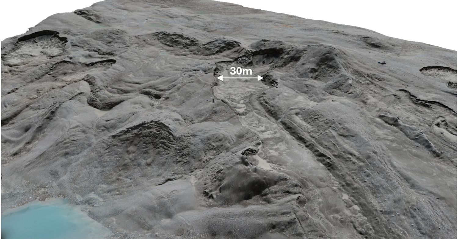
Cynthia Sassenroth, Andreas Johnsson, Ernst Hauber, Tilman Bucher, Michael Angelopoulos, Simon Berquez, Bernard Hallet, Michael Zanetti, Ivar Berthling, Nico Schmedemann, and Harald Hiesinger

Understanding landforms and quantifying rates of surface change in cold-climate regions remain some of the key challenges in interpreting ice-related landforms on Mars. Polygonised terrains, lobate debris aprons, gullies, viscous flow features, and ice-rich mantling deposits observed across the Martian mid-latitudes are commonly interpreted as evidence for near-surface ice, glacial activity, freeze-thaw processes, and potentially liquid water [1-8]. However, many Martian landforms remain difficult to interpret because similar morphologies may form through different processes [9]. Terrestrial analogue studies are therefore essential for constraining process-form relationships, quantifying rates of landscape evolution, and identifying geomorphological signatures diagnostic of ice- and water-related surface processes [10].

The rapidly evolving permafrost landscapes of western Svalbard are very instructive natural laboratories for investigating cold-climate geomorphological processes relevant to Martian mid-latitude terrains [6,11,15]. Within the framework of the Svalbard Permafrost Landforms as Analogues for Mars (SPLAM) initiative, repeated airborne and field-based investigations have been conducted since 2008 in the Ny-Ålesund region, including Kvadehuksletta, the Kongsfjorden lateral moraine systems, and recently deglaciated forefields such as Engelsbukta [11-13]. These investigations build upon pioneering long-term periglacial monitoring studies initiated during the 1980s at Kvadehuksletta and surrounding areas [12] and are complemented by long-term atmospheric and permafrost monitoring sites in the Ny-Ålesund region [18]. Together, these datasets provide a rare opportunity to investigate geomorphological and permafrost dynamics across seasonal to multi-decadal timescales. The monitored environments serve as terrestrial analogues for polygonised terrains, latitude-dependent mantle deposits, lobate debris aprons, viscous flow features, and gully-associated landforms observed on Mars.

SPLAM has established a >15-year multi-temporal geomorphic monitoring record integrating photogrammetry (Fig. 1), airborne and mobile LiDAR surveys [14], geomorphological mapping, ground-penetrating radar (GPR) [17], electrical resistivity tomography (ERT), and repeat sedimentological and permafrost field investigations. Remote sensing imagery acquired RGB, near-infrared, and thermal datasets used to generate centimeter-scale orthomosaics and Digital Surface Models (DSMs; Fig. 1). All datasets are geodetically constrained using differential Global Navigation Satellite System (dGNSS) measurements with cm-scale accuracy. Multi-temporal DSM differencing and morphometric analyses were generated to quantify cm-scale surface changes since 2008 [14,15].

Figure 1: Ultra-high-resolution (cm-scale) Digital Surface Model (DSM) of the ice-cored lateral moraine system at Kongsfjorden, western Svalbard. The moraine is characterized by active debris-flows, rapid surface changes, and widespread thermokarst degradation associated with ice melt. The retrogressive degradation of the scarp reaches several meters per week. The DSM was generated from stereo-imagery acquired using a kite-based camera system, operating approximately 30 m above ground, and structure-from-motion photogrammetry (image credit: N. Schmedemann, 2026).

Subsurface investigations play a central role in the SPLAM framework and aim to link remotely observable surface features with subsurface characteristics such as active layer thickness, permafrost table depth, soil grain-size distribution, mineralogical composition, moisture conditions, and temperature. GPR surveys are used to characterize shallow subsurface architecture, buried ice bodies, and internal moraine structure. ERT and electromagnetic resistivity measurements provide complementary constraints on subsurface ice distribution, saline permafrost occurrence [13], sediment moisture conditions, and freeze-thaw dynamics. The integration of geophysical and remote sensing datasets enables direct comparison between surface morphology and subsurface permafrost conditions.

Current work focuses on quantifying surface changes and the rates at which they occur in diverse terrain that includes degrading ice-cored moraines, thermokarst development, active layer dynamics, cryopeg occurrence, active patterned ground (Fig. 2), and paraglacial adjustment following glacier retreat. By integrating long-term remote sensing, geophysical, and field datasets, SPLAM investigates how rapidly evolving Arctic permafrost systems respond to environmental change, and how these processes can improve interpretations of Martian periglacial environments relevant for future planetary exploration and in-situ resource utilization (ISRU) [4,16].

Figure 2: Active sorted circles in Kvadehuksletta, Svalbard.  These circles, meters in diameter within gravel ridges up to 0.3 m high, are among the best developed worldwide and they coexist with other patterned ground features, including sorted stripes, sorted nets, and thermal contraction polygons (image credit: B. Hallet, 1988).

References

[1] Plaut et al. (2009) GRL 36, L02203. https://doi.org/10.1029/2008GL036379 [2] Dundas et al. (2018) Science 359, 199-201. https://doi.org/10.1126/science.aao1619 [3] Warren et al. (2024) Planetary Science Journal 5, 174. https://doi.org/10.3847/PSJ/ad5e6f [4] Sako et al. (2025) JGR Planets 130, e2023JE008232. https://doi.org/10.1029/2023JE008232 [5] Malin & Edgett (2000) Science 288, 2330-2335. https://doi.org/10.1126/science.288.5475.2330 [6] Hauber et al. (2011) Geological Society Special Publication 356, 111-131. https://doi.org/10.1144/SP356.7 [7] Gallagher et al. (2011) Icarus 211, 458-471. https://doi.org/10.1016/j.icarus.2010.09.010 [8] Dickson et al. (2023) Science 380, 1363-1367. https://doi.org/10.1126/science.abk2464 [9] Hallet et al. (2022) JGR Planets 127, e2021JE007126. https://doi.org/10.1029/2021JE007126 [10] Baker (2014) Planetary and Space Science 95, 5-10. https://doi.org/10.1016/j.pss.2012.10.008 [11] Sassenroth et al. (2023) Geografia Fisica e Dinamica Quaternaria 46, 135-151. https://doi.org/10.4454/23dce671 [12] Hallet, B., 2013. Stone circles: form and soil kinematics. Phil. Trans. Royal Soc. A: Math, Phys. and Eng. Sci, 371 (2004) https://doi.org/10.1098/rsta.2012.0357. [13] Angelopoulos et al. (2025) EGU25-19953. https://doi.org/10.5194/egusphere-egu25-19953 [14] Zanetti et al. (2025) LPSC 56, #2124 [15] Hauber et al. (2025) EPSC-DPS2025-1794. https://doi.org/10.5194/epsc-dps2025-1794 [16] Morgan et al. (2025) Planetary Science Journal 6, 29. https://doi.org/10.3847/PSJ/ad9b24 [17] Johantges et al. (2024) LPSC 55, #2611  [18] Boike et al. (2018) Earth System Science Data 10, 355-390. https://doi.org/10.5194/essd-10-355-2018

How to cite: Sassenroth, C., Johnsson, A., Hauber, E., Bucher, T., Angelopoulos, M., Berquez, S., Hallet, B., Zanetti, M., Berthling, I., Schmedemann, N., and Hiesinger, H.: Svalbard Permafrost Landforms as Analogues for Mars (SPLAM): Long-Term Monitoring of Permafrost Dynamics and Water-Related Surface Processes , Europlanet Science Congress 2026, The Hague, The Netherlands, 7–11 Sep 2026, EPSC2026-911, https://doi.org/10.5194/epsc2026-911, 2026.

F2.27
|
EPSC2026-938
|
ECP
|
On-site presentation
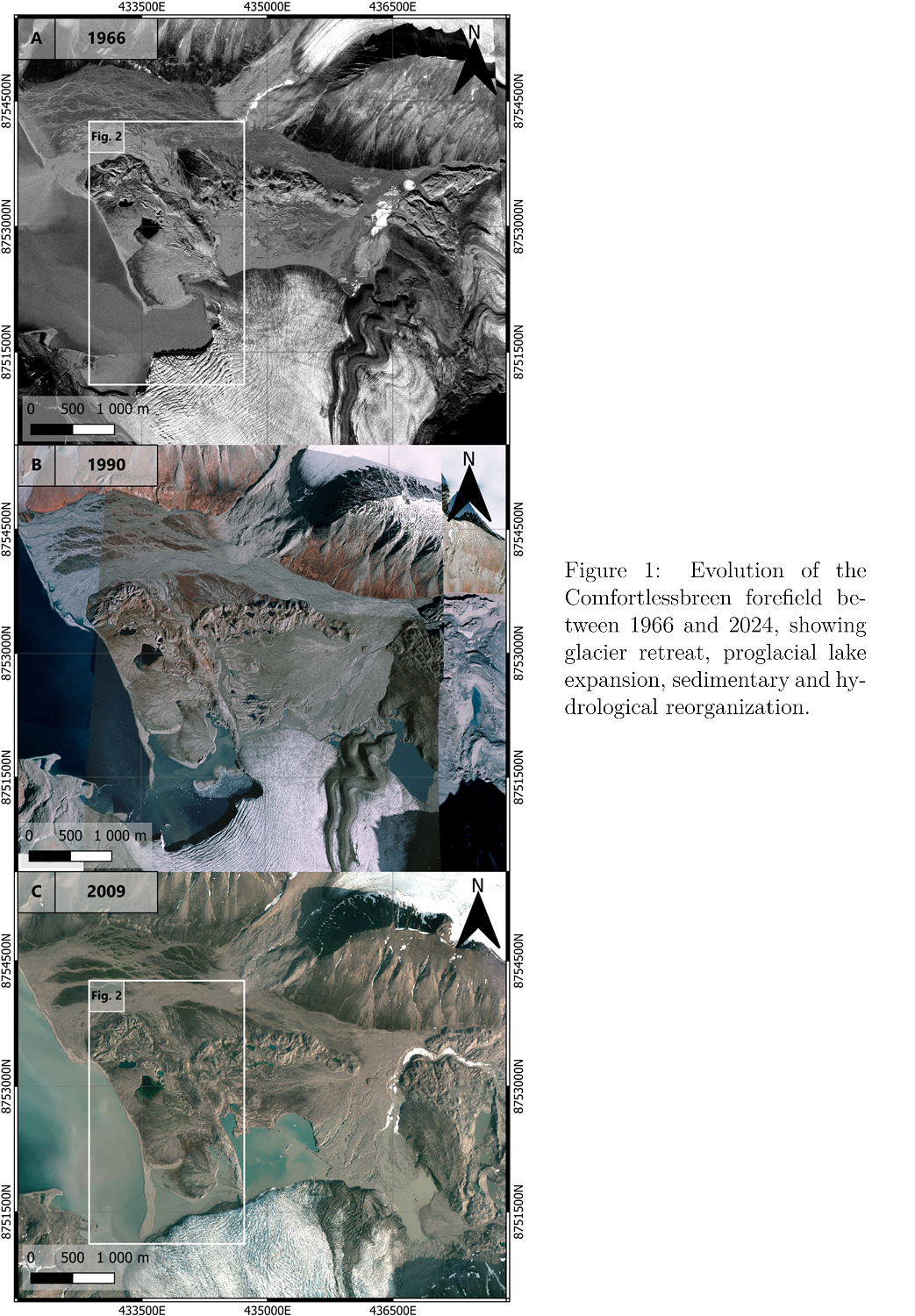
Simon Berquez, Andreas Johnsson, Susan Conway, Cynthia Sassenroth, Mark Johnson, Michael Angelopoulos, Tilman Bucher, Bernard Hallet, Ernst Hauber, Harald Hiesinger, Jan Kavan, Nico Schmedemann, and Michael Zanetti
Introduction
Artic proglacial systems represent valuable terrestrial analogues for Martian cold-climate environments (Hauber et al., 2011), as they allow observation of processes responsible forming cold-climate landforms on Mars. In particular, the presence and distribution of ground ice on Mars are of major scientific interest, to understand its past hydrology, evaluate potentially habitable environments, and identify water resources for future exploration and in situ resource utilization (ISRU).
In Svalbard, the glacier retreat and buried ice degradation produce dynamic landscapes, evolving at human timescales, generating collapse features (Hibbard et al., 2025), reorganizing hydrological systems, and reshaping sedimentary structures (Kavan et al., 2024). Studying these environments and linking them to ground ice and permafrost dynamics provides insights into the formation and preservation of cold-climate landforms potentially comparable to Martian surface textures and collapse patterns, which may represent frozen snapshots of past glacial and hydrological activity.
The objective of this work is to assess what changes affect this proglacial environment, affected by interactions between glacial, periglacial, hydrological, sedimentary, and coastal processes, generating complex assemblages. A particular attention is given to the degradation of buried ice affecting the sedimentary systems of the region.
Site & Methods
Located on the western coast of Svalbard (Norway; 78.83°N, 12.00°E), the Comfortlessbreen–Uvêrsbreen area comprises several interacting glacial systems. Glacial, periglacial, fluvial, coastal, and slope processes shaped the landscape, forming multiple generations of landforms and sedimentary units.
To investigate this landscape in detail for the first time, we carried out a multitemporal analysis of the site using orthophotos acquired by the Norwegian Polar Institute (NPI) in 1966, 1990, and 2009, and data obtained from MACS flights conducted under the German Aerospace Center (DLR) supervision in 2024. The orthophotos are complemented by near-infrared (NIR) data, used to investigate 2009 patterns, and a 2024 highresolution DEM (10cm/pixel), allowing detailed geomorphological observations. The datasets are used to identify and characterize glacial, proglacial and sedimentary landforms from regional to metric scale.
Results
Landscape evolution and collapse dynamics
At regional scale, the retreat of the glacier fronts led to the reshaping of large surfaces occupied by ice-cored ground moraines, overlain by sedimentary deposits. At intermediate scales, these processes manifest through the evolution of coastal fluvio-glacial fans, from their development and abandonment to their collapse due to buried ice degradation, as shown by kettle holes and thermokarsts. At smaller scales, the surface of these fans display collapse morphologies, including kettle holes and ring-like features linked to buried ice degradation.
Multi-temporal observations reveal rapid landscape reorganization over the last decades, mainly driven by glacial retreat (Figure 1). The withdrawal of Comfortlessbreen between 1966 and 2024 exposed ice-rich subglacial terrains, which degraded, collapsing the overlying sediments. This process resulted in the formation of a proglacial lake system in two decades.
Sedimentary fan dynamics
The fans observed are connected to glacier activity and meltwater circulation. Two main processes control these structures formation: long-term meltwater runoff, responsible for the construction of the large outwash fan, and sediment-laden water pulses released from the glacier, associated with post-surge activity, responsible for the sedimentary fans located near the shoreline (Figure 2).
Several of these fans display evidence of polyphased evolution, with successive deposits partially overlapping older units. In some instances, abandoned fan surfaces are destabilized by buried ice degradation, while newer pulses reorganize the drainage system. The organisation of these structures suggest a topographic control of the surrounding bedrock ridges and former glacier margins on the present proglacial landscape.
Collapse terrains
The difference in collapse features distribution between the coastal fans and the large inner outwash fan, suggests that different depositional processes resulted in distinct buried ice organisation, controlling the patterns. For instance, on the large outwash fan developing near the proglacial lake, trench-like features appear aligned along former moraine ridges or sedimentary structures, indicating that buried ice preservation may have been influenced by glacial topography (Figure 3). Such morphologies have been described in association with thermokarst processes and buried ice collapse in Arctic environments, making this setting potentially relevant as analogue for Mars cold-climate landforms. 
Additional thermal imagery datasets reveal strong spatial relationships between cold water ponds and terrains enriched in ring-like features. These observations support the interpretation that buried ice degradation is still active.
Conclusion
These rapidly evolving Arctic proglacial systems provide valuable analogues for understanding the formation and preservation of collapsed cold-climate landforms on Mars. Our observations show that buried ice degradation influences landscape evolution, hydrological reorganization, and surface morphology, offering insights into the origin of Martian terrains potentially linked to former glacial activity.
 
References
E. Hauber et al,. Landscape evolution in martian mid-latitude regions: insights from analogous periglacial landforms in svalbard. Geological Society, London, Special Publications, 2011.
S. M. Hibbard et al,. Glacial ring forms on axel heiberg island, nunavut, Canada. The Cryosphere, 2025.
Jan Kavan et al,. Glacier surge as a trigger for the fastest delta growth in the arctic. Communications Earth & Environment, 2024.

How to cite: Berquez, S., Johnsson, A., Conway, S., Sassenroth, C., Johnson, M., Angelopoulos, M., Bucher, T., Hallet, B., Hauber, E., Hiesinger, H., Kavan, J., Schmedemann, N., and Zanetti, M.: Buried Ice Degradation and Rapid Proglacial Landscape Evolution in Svalbard: Implications for Martian Cold-Climate Geomorphology, Europlanet Science Congress 2026, The Hague, The Netherlands, 7–11 Sep 2026, EPSC2026-938, https://doi.org/10.5194/epsc2026-938, 2026.

F2.28
|
EPSC2026-939
|
ECP
|
On-site presentation
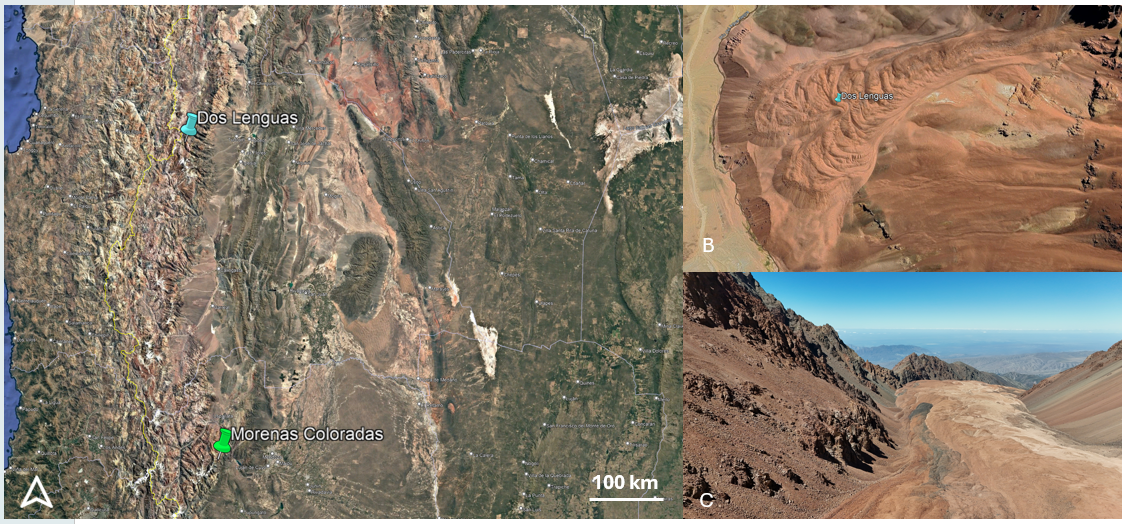
Silvia Bertoli, Nicole Costa, Giovanni Munaretto, Adriano Tullo, Carla Tapia, Andrés Lo Vecchio, José Luis Seco, Costanza Morino, Matteo Massironi, Gabriele Cremonese, and Cristina Re

Introduction: Martian glacier-like forms (GLFs) [1] represent some of the most important indicators of past ice accumulation and volatile redistribution in the Martian mid-latitudes. Their morphology preserves evidence of glacial and periglacial processes potentially linked to climatic and obliquity-driven fluctuations. However, despite the widespread occurrence of these landforms, the relationship between surface morphologies, preservation state, and internal ice content remains poorly constrained. In particular, the interpretation of morphometric signatures derived from orbital datasets in the context of Martian GLFs still lacks robust validation, limiting our understanding of the climatic evolution and present-day stability of Martian mid-latitude ice reservoirs.

In this work, we apply a comparative geomorphological approach between Martian GLFs and terrestrial rock glaciers in the Dry Argentine Andes. The terrestrial analogues investigated include the Dos Lenguas rock glacier [2] and the Morenas Coloradas rock glacier complex. Dos Lenguas is an active tongue-shaped rock glacier located in the upper Agua Negra basin (~30°S), characterized by well-developed ridge-and-furrow systems, compressional structures, and active creep processes. Previous studies highlighted significant surface kinematics and topographic variability associated with active permafrost deformation and internal ice-rich conditions [3]. The Morenas Coloradas complex instead represents an ice-debris-complex which consists of complex landforms, transitioning from debris-covered glaciers or ice-cored moraines into rock glaciers downslope [4, 5].

The main goal of this study is to investigate whether quantitative morphometric parameters derived from DTMs can provide diagnostic indicators of ice preservation, degradation state, and flow-related processes on Martian GLFs, using the terrestrial analogues to support the comparison and validation of morphometric signatures.

Methods: We start producing a preliminary global database of Martian GLFs, from which representative targets were selected for detailed analyses based on preservation state, geological context, and the availability of high-resolution datasets. The high-resolution investigations rely on HiRISE [6] and CaSSIS [7] imagery and DTMs, which we used as the basis for our morphometric analyses. The analyses focus on the characterization of ridge spacing, ridge-and-furrow systems, surface textures, slope variability, and longitudinal and transverse topographic profiles. Ridge spacing measurements were performed by manually tracing ridge crests on QGIS. Distances between adjacent ridges were then calculated along transects approximately perpendicular to the dominant ridge orientation and parallel to the runout direction.

To aid the interpretation of Martian landforms, a dedicated field campaign was conducted in March 2026 in the Central Andes of Argentina on the Dos Lenguas and Morenas Coloradas rock glaciers (Fig. 1) in collaboration with the IANIGLA-CONICET institute (Mendoza, Argentina). UAV surveys were performed across active, transitional, and relict sectors of rock glaciers in order to acquire very high-resolution imagery suitable for photogrammetric reconstruction and DTM generation. The campaign also included geomorphological observations focused on ridge morphology, surface texture variability and frontal structures.

Fig. 1 – Google Earth view shows the location of the two rock glaciers studied in Argentina. B) Dos Lenguas rock glacier from Google Earth. C) Photo taken by drone of Morenas Coloradas rock glacier (credit Andrés Lo Vecchio).

Preliminary observations on Mars:

We selected a first Martian rock glacier located north of Reull Vallis (Fig. 2), along the eastern margin of Hellas Planitia. The area is characterized by multiple flow-related features, GLFs, and Lobate Debris Aprons, supporting a periglacial origin for these landforms.

Fig. 2 – The location of the rock glacier-like features, highlighted by the yellow boxes (details in the right picture)

Preliminary geomorphological observations of this rock glacier suggest that some large-scale ridge systems may deform and reorganize pre-existing brain-terrain textures [8]. Smaller-scale surface textures appear progressively compressed, stretched, and locally reoriented along the flanks and crests of the major ridges (Fig. 3). These relationships suggest that the observed morphologies may not represent a single-stage surface texture, but rather the superposition of multiple deformation phases affecting the ice-rich landform.

Fig. 3:  A detailed view of one of the ridges. The dashed line indicates the crest and the arrow the direction of the flow.

The morphometric measurements performed on the GLFs reveal the presence of two distinct ridge-spacing populations. The smaller-scale ridges exhibit regular spacing ranging between ~56 and 114 m, with an average spacing of ~90 m, forming closely spaced and laterally continuous surface textures. Larger ridge systems display wider and more irregular spacing (~240–505 m, Fig. 4), and are associated with more pronounced topographic relief and large-scale compressional structures. The transition between these two morphologic domains appears gradual, with the smaller-scale textures becoming progressively compressed and reorganized toward the larger ridge systems. These observations suggest a hierarchical surface organization potentially linked to different scales or generations of deformation within the landform. In particular, the smaller and more regularly spaced ridges may reflect an earlier phase of surface texturing or distributed deformation, whereas the larger ridge systems may represent later localized compressional creep structures developed during the subsequent evolution of the GLF.

Fig. 4: The section A-B shows the topographic profile, which highlight the larger ridges.

Next step: The work comprehends comparative analyses of both Martian and terrestrial rock glaciers. The generation of high-resolution DTMs for the Dry Andean analogues is currently ongoing, while additional Martian GLFs will be investigated as new topographic datasets from CaSSIS and HiRISE become available.

Acknowledgements:  This work has been developed under the ASI-INAF agreement n. 2024- 40-HH.0. We thank the IANIGLA-CONICET team for logistical and scientific support during the field campaign in the Andes.

References:

[1] Driver G., et al. (2024). Journal of Geophysical Research: Planets, 129.

[2] Halla C. et al. (2021) The Cryosphere, 15, 1187–1213.

[3] Tapia-Baldis, C. and Trombotto-Liaudat, D. (2020). Cuadernos de Investigación Geográfica, 46, 33–58.

[4] Blöthe, J.H. et al. (2021). Earth Surf. Process. Landforms 46, 504–522.

[5] Haeberli, W. et al. (2024). The Cryosphere 18, 1669–1683.

[6] McEwen A. S., et al. (2007). Journal of Geophysical Research: Planets, 112.

[7] Thomas N., et al. (2017).  Space Science Reviews, 212.

[8] Levy J., Head J., and Marchant D. (2009). J. Geophys. Res., 114.

How to cite: Bertoli, S., Costa, N., Munaretto, G., Tullo, A., Tapia, C., Lo Vecchio, A., Seco, J. L., Morino, C., Massironi, M., Cremonese, G., and Re, C.: Terrestrial analogues for Martian glacier-like forms: insights from rock glaciers in the Dry Andes of Argentine., Europlanet Science Congress 2026, The Hague, The Netherlands, 7–11 Sep 2026, EPSC2026-939, https://doi.org/10.5194/epsc2026-939, 2026.

F2.29
|
EPSC2026-433
|
ECP
|
On-site presentation
Nicole Costa, Silvia Bertoli, Giovanni Munaretto, Adriano Tullo, Gabriele Cremonese, Matteo Massironi, Pamela Cambianica, Cristina Re, Elena Martellato, and Maddalena Faletti

Introduction:

Viscous Flow Features (VFFs) on Mars are predominantly located at mid-to-high latitudes and share significant similarities with terrestrial glaciers. These features include high water-ice content, generally downslope flow patterns, heterogeneous deformation structures, and they are typically protected by a layer of debris [1]. Among these, Glacier-Like Forms (GLFs) resemble terrestrial valley or rock glaciers. Their surfaces are characterized by distinctive lineations, crevasses, and moraine-like ridges [2]. On the case of the Earth, rock glaciers are periglacial landforms resulting from the cohesive downslope flow of permafrost and frozen debris [3].

While these geomorphological features serve as critical indicators of the Martian paleoclimate fluctuations and represent potential water reservoirs for human missions, significant knowledge gaps remain. In particular, the mechanisms of their formation and their state of activity are not fully understood. In this context, detailed geomorphological mapping represents a fundamental initial step, as it allows the identification of surface units, morphologic relationships, and degradation patterns, providing the spatial and geological framework necessary to investigate the evolution, preservations state, and ice-related processes affecting Martian GLFs.

In this project, starting from the creation of a global database of GLFs on Mars, representative targets were selected for detailed geomorphological mapping and morphometric analyses. This multi-scale approach allows the investigation of surface processes and evolutionary trends across different glacial and periglacial environments on Mars.

The study aims to characterize the preservation state of GLFs, assess the potential preservation of subsurface ice beneath debris covers, and reconstruct the geomorphological and climatic framework controlling their formation and evolution on Mars.

Methodology:

To achieve these objectives, a multi-scale remote sensing approach was adopted, combining global surveys with detailed local investigations of selected targets. The analyses are based on data from:

  • HiRISE: high-resolution images and DTMs of the surface [4];
  • CaSSIS: colored and stereo high-resolution images and DTMs of the surface [5];
  • CRISM: compositional and mineralogical information [6];
  • SHARAD: subsurface stratigraphy and ice thickness [7].

Preliminary results:

The first step of this study involved the creation of a preliminary global database of potential Martian rock glaciers (Figure 1). This database allows us to i) analyze the latitudinal distribution of these features, ii) identify possible clustering of GLFs and iii) investigating their relationship with regional geomorphological and climatic settings.

Figure 1. Global distribution of identified Martian rock glaciers, based on database information.

Following this global assessment, we selected high-priority targets for detailed mapping. These were chosen based on the availability of high-resolution data and their potential to provide insights into favorable formation environments, local geology, and activity states (e.g., active vs. relict forms). Rock glaciers are not strictly related to craters. By identifying these landforms in non-crater areas, such as Mons, this work demonstrates a broader spatial distribution of these features.

Based on the initial database, a primary set of targets has been identified, and some geological maps have been produced, like Figure 2 [8]. The mapped crater is located in Noachis Terra (40°S, 4°E), a region characterized by extensive evidence of periglacial and glacial geomorphology. The crater itself hosts various periglacial landforms, in particular the equator-facing slope displays different GLFs. Furthermore, a prominent rock glacier, measuring 4.1 km in length and covering an area of ~10 km², is situated within this crater.

Figure 2. Detailed geological map of an impact crater (40°S, 4°E), hosting different GLFs and a rock glacier.

Conclusions:

Glacier-Like Forms (GLFs) can be indicative of the past climate changes on Mars preserved through their internal ice content and morphological state, to better constrain the formation and evolution of glacial features across the Red Planet (see also Bertoli et al. submitted to this EPSC). Furthermore, new high-interest targets highlight the need for further high-resolution data; indeed, we plan to acquire new CaSSIS data and stereo pairs, providing the detail required to characterize these areas.

Acknowledgements:

This work has been developed under the INAF-OAPD fellowship within the CaSSIS TGO e MARSIS MEX projects and the ASI-INAF agreement n. 2024- 40-HH.0.

References:

[1] Driver G., et al. (2024). Large glacier-like forms on Mars: Insights from crater morphologies and crater retention ages. Journal of Geophysical Research: Planets, 129. https://doi.org/10.1029/2023JE008207

[2] Hubbard B., et al. (2014). Glacier-like forms on Mars. The Cryosphere, 8. https://doi.org/10.5194/tc-8-2047-2014

[3] Meng T. M., et al. (2025). Effects of rock glacier dynamics on surface morphology and deformation. Journal of Geophysical Research: Earth Surface, 130. https://doi.org/10.1029/2024JF008106

[4] McEwen A. S., et al. (2007). Mars Reconnaissance Orbiter's High Resolution Imaging Science Experiment (HiRISE). Journal of Geophysical Research: Planets, 112. https://doi.org/10.1029/2005JE002605

[5] Thomas N., et al. (2017). The Colour and Stereo Surface Imaging System (CaSSIS) for the ExoMars Trace Gas Orbiter. Space Science Reviews, 212. https://doi.org/10.1007/s11214-017-0421-1

[6] Murchie S., et al. (2007). Compact Reconnaissance Imaging Spectrometer for Mars (CRISM) on Mars Reconnaissance Orbiter (MRO). Journal of Geophysical Research: Planets, 112. https://doi.org/10.1029/2006JE002682

[7] Seu R., et al. (2007). SHARAD sounding radar on the Mars Reconnaissance Orbiter. Journal of Geophysical Research: Planets, 112. https://doi.org/10.1029/2006JE002745

[8] Bertoli S., et al. (2025). Martian and Terrestrial Rock Glaciers: Paleoclimatic Insights, Permafrost Dynamics, and Implications for Astrobiology. Biennial European Astrobiology Conference (BEACON), abstract, Reykjavik (IS), 1-5/07/2025.

How to cite: Costa, N., Bertoli, S., Munaretto, G., Tullo, A., Cremonese, G., Massironi, M., Cambianica, P., Re, C., Martellato, E., and Faletti, M.: Geomorphological characterization and mapping of Martian rock glaciers, Europlanet Science Congress 2026, The Hague, The Netherlands, 7–11 Sep 2026, EPSC2026-433, https://doi.org/10.5194/epsc2026-433, 2026.

F2.30
|
EPSC2026-1133
|
On-site presentation
Ari Leppälä, Karri Muinonen, Anne Virkki, Antti Penttilä, Hanna Pentikäinen, and Gorden Videen

Europa’s photometric and polarimetric behaviour in UV-Vis-NIR light provides constraints on the microphysical properties of its uppermost regolith. At small phase angles, approximately below 20 degrees, atmosphereless bodies exhibit non-linear brightening near the backscattering direction as well as negative linear polarization, in which the scattered light is polarized parallel to the Sun–object–observer scattering plane. These phenomena are sensitive to particle size, shape, and refractive index, as  well as to regolith packing density, as they arise from electromagnetic wave scattering in discrete media composed of small particles, including interference between reciprocal light paths traversed in opposite directions. Photometric and polarimetric observations can therefore be used to probe the structure and composition of the near-surface scattering medium.


In earlier work, we modeled the small-phase-angle polarimetric phase curves of the Galilean satellites [1 , 2] using radiative-transfer coherent-backscattering (RT-CB) calculations [3 –5] with ensemble-averaged scattering matrices. For Europa, this approach reproduced key characteristics of the observed negative polarization branch using disk-integrated polarimetric observations. A recent study [6] further demonstrated the diagnostic potential of Mueller matrix elements beyond those describing linear polarization alone.


In the present work, we extend this modeling framework by replacing generic single-scattering inputs with scattering matrices derived from physically constrained particle models for Europa’s icy surface. The particle ensembles considered here include randomly shaped and randomly oriented particles with effective sizes in the approximate range 0.1–2.0 μm. Their single-scattering properties are computed using numerical electromagnetic methods, including the Discrete Dipole Approximation (ADDA) [7] (0.1–0.5 μm) and the surface-integral-equation method [8] (0.1–2.0 μm). These calculations are complemented by the scattering properties of larger Gaussian particles generated with the SIRIS-4 code [9 , 10], resulting in ensemble-averaged scattering matrices representative of a physically motivated near-surface composition. The resulting ensemble-averaged scattering matrices are used as input for the RT-CB modeling of Europa’s photometric and polarimetric phase curves. Furthermore, decomposition of the ensemble-averaged scattering matrix into polarization-conserving Mueller matrices [4] enables RT-CB computations for discrete random media composed of nonspherical particles [5]. This decomposition facilitates the interpretation of near-surface structure and composition by comparing RT-CB model results with observations [11].


We apply extended RT-CB computations to a surface model consisting of a layer of wavelength-scale amorphous ice particles overlying crystalline ice particles that are large compared with the wavelength; see Muinonen et al., present conference. At radar wavelengths, we model absorbing particles embedded in pure crystalline water ice. Using radar observations of same-circular (SC) and opposite-circular (OC) polarization [12, 13], we aim to estimate the relative abundance of pure water ice and more absorbing impurities. Previous studies have addressed this using coherent-backscatter and multiple-scattering models (e.g., [14]). Here, we apply the extended RT-CB model to investigate whether these polarization measurements can provide additional constraints on the relative abundance of pure water ice and more absorbing impurities.


By simulating light scattering from near-surface composition models with specified physical properties and comparing the results with ensemble-averaged scattering matrices and observations, we obtain constraints on the compositional and structural characteristics of Europa’s surface, including particle size distribution, packing density, and impurity content. The RT-CB model, combined with photometric and polarimetric measurements, provides a valuable tool for characterizing Europa, other icy satellites, and airless bodies using both ground-based observations and spacecraft measurements. Regolith parameters retrieved through RT-CB modeling can serve as boundary conditions for simulations of particle release into the surface-bounded exospheres of Jovian moons, thereby supporting the science goals of the JUICE and Europa Clipper missions.

references

[1] N. Kiselev et al., ”New Polarimetric Data for the Galilean Satellites : Europa Observations and Modeling” Planet. Sci. J. 3, 134 (2022)

[2] N. Kiselev et al., ”New Polarimetric Data for the Galilean Satellites: Io and Ganymede Observations and Modeling,” Planet. Sci. J. 5, 10 (2024)

[3] K. Muinonen et al., ”Coherent Backscattering Verified Numerically for a Finite Volume of Spherical Particles,”ApJ 760, 118 (2012)

[4] K. Muinonen, A. Penttilä, ”Scattering matrices of particle ensembles analytically decomposed into pure Mueller matrices,” JQSRT 324, (2024)

[5] K. Muinonen et al., ”Coherent backscattering in discrete random media of particle ensembles,” JQSRT 330,(2025)

[6] A. Leppälä, K.Muinonen, A. Penttilä, et al., JQSRT, submitted (2026)

[7] M. A. Yurkin, A. G. Hoekstra, ”The discrete-dipole-approximation code ADDA: Capabilities and known limitations,” JQSRT 112, 13 (2011)

[8] J. Markkanen, ”Surface-integral-equation solution for solid particles with wavelength-scale surface roughness,” JQSRT 341, (2025)

[9] K. Muinonen et al., ”Light scattering by Gaussian particles with internal inclusions and roughened surfaces using ray optics,” JQSRT 110, (2012)


How to cite: Leppälä, A., Muinonen, K., Virkki, A., Penttilä, A., Pentikäinen, H., and Videen, G.:  Europa’s Icy Regolith characterized by modeling of radar and UV-Vis-NIR Scattering, Europlanet Science Congress 2026, The Hague, The Netherlands, 7–11 Sep 2026, EPSC2026-1133, https://doi.org/10.5194/epsc2026-1133, 2026.

F2.31
|
EPSC2026-617
|
On-site presentation
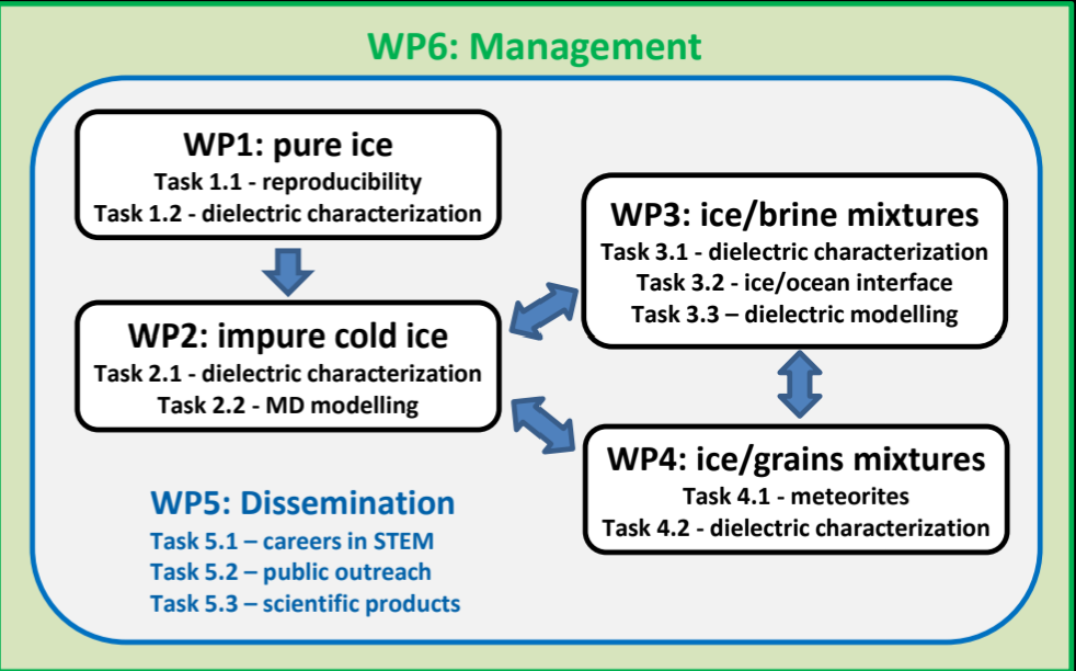
Elena Pettinelli

Radar sounder is a very reliable method to investigate the subsurface structure of planets and moons, as the dry and cold conditions of their outer shells are favorable environments for deep signal penetration. In few years, two spacecrafts, ESA/JUICE and NASA/Europa Clipper will start to scan the icy crusts of Europa, Ganymede and Callisto using RIME (Radar for Icy Moons Exploration)) and REASON (Radar for Europa Assessment and Sounding: Ocean to Near-Surface). Interpreting radar data and, in particular, detecting the presence of liquid water requires an extensive knowledge of the dielectric properties of the materials composing the ice shells through which the radio waves propagate. Our understanding of such properties is very limited and must be profoundly expanded before JUICE and EUROPA CLIPPER will start to collect data. To fill this gap, we have developed the project SWIM (Surfing radio waves to detect liquid water in the Solar System) which has been funded in 2024 by the European Research Council in the framework of the ERC Advanced Grant.

Figure 1 Work Package organization of the SWIM project

The project intend to integrate laboratory measurements regarding the dielectric properties of pure and doped water ice (also mixed with meteoritic materials), with molecular dynamics and dielectric modelling, to characterize the different targets expected to be present in the icy crusts of Europa, Ganymede and Callisto (Figure 1). The final goal of the project is to build a reliable dielectric model of the icy crusts and support the radar investigations in detecting subglacial liquid water and assessing the habitability conditions of such moons. Here we present the rationale of the SWIM project, together with some preliminary results.

How to cite: Pettinelli, E.: Assessing the dielectric properties of the Galilean moons icy crusts integrating laboratory measurements and modelling, Europlanet Science Congress 2026, The Hague, The Netherlands, 7–11 Sep 2026, EPSC2026-617, https://doi.org/10.5194/epsc2026-617, 2026.

F2.32
|
EPSC2026-1106
|
On-site presentation
Elodie Gloesener, Michele Ciulla, Bertrand Chazallon, Mathieu Choukroun, Tuan H. Vu, Ashley G. Davies, Claire Pirim, Pietro Di Profio, and Christophe Sotin

The hydrosphere of volatile-rich objects in the outer Solar System likely contains clathrate hydrates. These compounds exhibit many physical properties similar to those of water ice Ih. However, differences in mechanical strength, thermal conductivity and density may substantially impact geologic processes, and the stability, composition and distribution of multicomponent clathrates in ocean worlds remain poorly constrained.

This study examines the composition of mixed clathrate hydrates that could form in ocean worlds and assesses their potential to sink or float, contributing to the formation of a clathrate layer at the top or bottom of the internal ocean. Using a model based on the statistical thermodynamic approach of van der Waals and Platteeuw [1], we evaluate the composition and density of mixed clathrate hydrates forming in pure water systems as well as in the presence of ammonia, an important thermodynamic inhibitor likely present in small amounts on icy moons. For the ammonia-bearing systems, we express the activity coefficient of water in the liquid phase based on the Margules equation as proposed by Choukroun and Grasset [2]. Our model is applied under conditions relevant to Europa, Titan, and Enceladus (255 K to 273 K and pressures up to several hundred MPa) and is compared with experimental cage occupancies and selectivity retrieved from Raman spectroscopy of mixed CH4-CO2 clathrate hydrates in pure water, and with preliminary high-pressure microcalorimetry dissociation temperature for the CH4-NH3-H2O system.

Given their influence on the thermal and rheological properties of ocean world ice shells, the timing, abundance, and location of clathrate reservoirs should be considered in evolution models. This work provides valuable insights for interior modeling of icy bodies and supports ongoing and future missions, including JUICE, Europa Clipper, and Dragonfly.

[1] J. van der Waals, J. Platteeuw (1958) Adv. Chem. Phys., 2, 1-57.

[2] Choukroun M. and Grasset O. (2010) J. Chem. Phys., 133, 144502.

How to cite: Gloesener, E., Ciulla, M., Chazallon, B., Choukroun, M., Vu, T. H., Davies, A. G., Pirim, C., Di Profio, P., and Sotin, C.: Clathrate Hydrates in Icy Moons: Experimental and Modeling Studies on the CH4-CO2-H2O and CH4-NH3-H2O Systems, Europlanet Science Congress 2026, The Hague, The Netherlands, 7–11 Sep 2026, EPSC2026-1106, https://doi.org/10.5194/epsc2026-1106, 2026.

F2.33
|
EPSC2026-387
|
ECP
|
On-site presentation
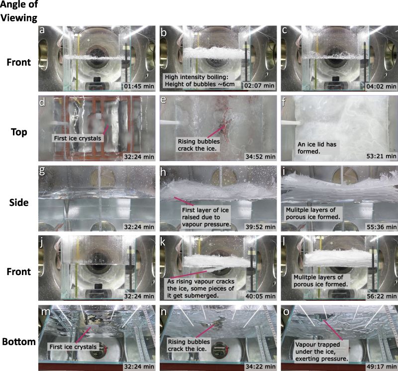
Priyanka Biju Sindhu, Petr Brož, Vojtěch Patočka, Mark Fox-Powell, Frances Butcher, Manish Patel, and Matthew Sylvest

Several icy worlds exhibit surface morphologies interpreted as products of effusive cryovolcanism (eg: [1-3]), yet the behaviour of saline liquids undergoing boiling, evaporative cooling, freezing, and salt precipitation under such low-pressure conditions remains poorly constrained because these processes cannot currently be directly observed. This study presents an experimental dataset of sixteen experiments documenting how large volumes (~40 kg) of water solutions with varying salinity behave when exposed to decreasing atmospheric pressure. The experiments were performed in the Large Dirty Mars Chamber (“George”) at the Open University, UK, and built upon  previous work (see [4]).

Each experiment used a 40 × 40 × 40 cm glass tank with a wall thickness of 0.05 m, containing ~40 kg of liquid placed within a cylindrical vacuum chamber capable of reaching pressures down to approximately 1 mbar. We used deionised water as reference, and solutions of NaCl, MgSO₄, and a mix of NaCl–MgSO₄ salts were used for the experiment. Salinities ranged from 0.5 wt% through 2.5 wt% and 5.0 wt%, to near-eutectic compositions of approximately 23.3 wt% NaCl and 17.4 wt% MgSO₄. Each combination of salinity and salt type had two experimental runs for consistency. This study focuses on static or weakly-mixed systems; experiments investigating turbulent flow regimes are presented separately [5].

The experiments generally evolved through three stages: an initial boiling-driven cooling stage, a transition marked by ice nucleation and ice-lid formation, and a later stage of progressive porous ice growth (see Fig. 1 for details). During early depressurisation, vigorous boiling dominates heat loss through latent heat of vaporisation (Fig. 1a-c). Despite intense boiling aactivity at the surface, vertical temperature gradients initially remained small throughout the liquid column. The first ice crystals appeared only after sufficient heat had been removed from the solution to lower surface temperatures below the freezing point of the given mixture, and the onset time increased with salinity. The near-eutectic NaCl experimental runs alone did not reach the freezing stage even in 6 hours. However, these and the near-eutectic MgSO₄ runs show nucleation of salt crystals on surface, later also submerged in the water.

Fig. 1: Progression of boiling and freezing in solution with 0.5% NaCl, when exposed to a low pressure environment. Exp6.

Ice formation followed thin translucent patches that nucleated locally, expanded radially, merged, and were repeatedly disrupted by vapour generated beneath them (see Fig. 2). As cooling progressed, these patches evolved into a mechanically coherent surface layer (ice lid), although at higher salinities this lid retained vents and did not always seal the surface completely. The ice lid changed the pathways of mass and heat transfer by reducing direct liquid exposure to the chamber atmosphere. 

Fig. 2: Detail showing the growth of ice - spreading and merging of floating ice crystals as seen from the top camera. Exp6, 0.5% NaCl

Unlike previous studies focusing mainly on end-member compositions ([6,7]), this dataset allows systematic comparison of how salinity and salt composition affect ice morphology and mechanical behaviour. One clear trend observed is that increasing salinity fundamentally alters both the mechanical behaviour and internal structure of the resulting ice. Low-salinity systems produced brittle, highly porous, multilayered ice crusts [4,6], whereas increasingly saline solutions produced more ductile and compact ice structures with reduced porosity and more stable vapour vents (Figs. 3, 5). 

At high salinities, freezing behaviour diverged significantly between MgSO₄ and NaCl systems. The 17.4 wt% MgSO₄ experiments produced highly ductile salty ice containing trapped salt and ice crystals, whereas 23.3 wt% NaCl runs formed only a disrupted pseudo-lid of precipitated salt crystals that partially suppressed evaporation and evaporative cooling (see [7]). Increasing salinity also systematically delayed freezing, extending the boiling-dominated stage from ~32 minutes in 0.5 wt% solutions to ~64 minutes in near-eutectic NaCl experiments. Higher-salinity solutions therefore lost more mass through evaporation before freezing began, although peak and late-stage mass-loss rates remained broadly similar across experiments. Cooling rates likewise decreased with increasing salinity, consistent with freezing-point depression and delayed ice-lid formation. 

Fig. 3: The figure shows four ice surfaces formed from solutions of increasing salinity, illustrating a clear transition from brittle to ductile mechanical behaviour as salt concentration increases.

Fig. 4: Plots showing the loss of mass over time from the solutions across different salinities.

Fig. 5: Views of ice formed from solutions of increasing salinity, illustrating the progressive decrease in ice-lid porosity with increasing salt concentration.

The thermal and mass-loss measurements additionally provide constraints for numerical modelling of evaporation-driven cooling under low-pressure conditions.  A preliminary model (Fig. 6) indicates that the heat sink during the pure evaporation stage can be modelled solely based on the mass lost from the system in this period. 

Fig. 6: Agreement of model with experimental data with cooling calculated from initial mass loss in the system. Exp6, 0.5% NaCl.

Our work provides experimental constraints to the behaviour of saline water and effusive cryovolcanic processes on icy moons such Europa, Enceladus, and Titan (also perhaps Pluto). As brines evaporate, cool, freeze, and become progressively enriched in salts, the morphology, porosity, and mechanical behaviour of the resulting ice crusts can change rapidly. The experiments suggest that salinity may exert a first-order control on the morphology, porosity, and mechanical stability of ice crusts forming during effusive cryovolcanism. Such differences are likely to influence vapour escape, crust permeability, and the long-term evolution of cryovolcanic deposits on icy worlds. Additionally, by comparing MgSO₄ and NaCl salts at different concentrations over repeated runs, the study establishes a foundation for future modelling of volatile loss, freezing rates, ice rheology, and the preservation potential of transient saline liquids under low-pressure planetary conditions.

References:

[1] Fagents, JGR, 108, E12 (2003) [2] Lesage et al. Nat Comm 16, 1886 (2025) [3] Wilson, JGR, 102, E4, (1997) [4] Brož et al. EPSL, 668 (2025) [5] Brož et al., EPSC abstract EPSC2026-190, (2026) [6] Patočka et al. EPSL, 685 (2026) [7] Fox-Powell et al. (2026), EGU abstract 26-21408.

How to cite: Biju Sindhu, P., Brož, P., Patočka, V., Fox-Powell, M., Butcher, F., Patel, M., and Sylvest, M.: Experimental Insights into Effusive Cryovolcanism: Boiling and Freezing of Saline Water under Low Pressure Conditions, Europlanet Science Congress 2026, The Hague, The Netherlands, 7–11 Sep 2026, EPSC2026-387, https://doi.org/10.5194/epsc2026-387, 2026.