
Ganymede’s Cratering Record
 1,2,3,2,
- 1University of Napoli Parthenope, Sciences and Technologies, Napoli, Italy (elena.martellato@uniparthenope.it)
- 2Institute for Space Astrophysics and Planetology, Via Fosso del Cavaliere 100, 00133 Roma, Italy
- 3Southwest Research Institute, 1050 Walnut St., Suite 300, Boulder, Colorado 80302 USA
Abstract
JUICE, JUpiter ICy moons Explorer, the ESA mission planned to be launched in 2022 and to arrive at Jupiter in 2029, will make detailed observations of Jupiter and three of its largest moons. One of its goals is to improve the current estimates of Ganymede surface age. As part of the future activities, we make new crater counts to be then used to refine current Ganymede crater-based chronology.
Impact craters are one of the most important landforms on planetary bodies with a solid surface (e.g., [2]). Crater morphology and their characteristic ejecta blankets of excavated materials provide important constraints to crustal stratigraphy, and variations of rheology with depth. Planetary landscapes exhibit a large number of impact craters, of very different size. Crater morphological “freshness” may represent a first qualitative hint to the relative ages of individual craters, while the quantitative analysis of impact crater populations is the primary tool to derive absolute ages of planetary and small body terrains.
One of the most commonly used chronological model was initially developed for the Moon and is based on relating crater counts at the Apollo/Luna landing sites to radiometric ages of the collected samples [4]. The lunar chronology has been then extrapolated to other planetary bodies, including the Galilean satellites (e.g., [3]), by making a number of assumptions including the source of the projectile population. Specifically for the Galilean satellites, other chronologies based on current estimates of the impact flux have been derived [8]. All these chronologies, however, suffer from a limited understanding of the variation of the impact flux with time for the Galilean system.
The aim of this project is to i) derive a revised crater counts for Ganymede, and ii) improve Ganymede crater chronology using the most updated understanding on the current and historical impact flux resulting from recent dynamical models. In this work, we will present our preliminary result in developing a newer crater database on Ganymede.
Ganymede was observed firstly by Voyager 1 and 2 in 1979, and then by Galileo between 1996 and 2000 through six flybys, which revealed that the surface has two main types of terrains, which differ in albedo, crater density, and surface morphology [6]. The first one, the “dark” terrains, is low albedo terrains, covered by regolith material, and heavily cratered. The second one, the “light” terrains, has higher albedo and lower crater density, suggesting a younger age. They can occur as smooth elongated and polygonal shaped areas, or as grooves. An accurate chronology for Ganymede can therefore provide information about resurfacing and the evolution of the surface, including the extent of the cryovolcanism [5].
The present global image mosaic of Ganymede is available at a resolution of ~1 km/pixel. Being only 74% of the surface at a resolution better than 2 km/pixel, either image resampling or degradation was applied [1], [6]. We select the areas of Ganymede acquired at the highest resolution (<100 m/pixel).
On the existing global geological map [1], [6], we performed cartographic refinement to better define the contours of the geological units used in this study. Crater counting is then performed by selected impact structure by means of photo-interpretation (e.g., primary vs secondary, degradation degree, peculiar morphology, ejecta blanket, etc.).
As case study, we report the crater count performed in Harpagia Sulcus, east of the prominent crater Enkidu, which gives an example of smooth material, fine material, and slightly grooved material [6]. The image data was ~116 m/pixel. The total number of the impact structures is 2657, 841 of which are considered bonafide “primary” craters (cf. Figure 1).
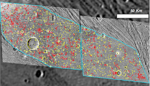
Figure 1. Crater counts performed in Harpagia Sulcus: Primary craters (yellow), and Secondary craters (red).

Figure 2. Cumulative size frequency distribution of the primary craters measured in the larger area (red) at 116 m/pixel, and in the smaller 16 m/pixel area (green).
A small selection of the studied area was available also at very high resolution (~16 m/pixel, blue polygon in Figure 1). We performed there an additional crater counts, finding 1575 impact structures, 619 of which are primaries. Comparing the two cumulative distributions of the primary craters (Figure 2), we found that a minimum resolution of 7 pixels is necessary to correctly detect primary craters from false crater-like features (circular features with an inner shade).
This study highlighted how a minimum crater diameter threshold of the order of ten pixels would be opportune to adequately develop crater statistics.
We obtained as cumulative number at 1 km N(1)~6×10⁻³. A previous study of [7] found N(1)~4×10⁻³ for similar aged terrains (Harpagian terrains, which are based on the bright tectonically resurfaced materials in Harpagia Sulcus).
This crater database and the new chronology model will improve our understanding of the geological evolution of the Galilean satellites, and lead the way to future investigations of the Jupiter System by the ESA JUICE mission
Acknowledgements
The authors acknowledge support to the project under ASI-INAF agreement n. 2018-25-HH.0.
References
[1] Collins et al.: Global geologic map of Ganymede. U.S. Geological Survey Scientific Investigations Map 3237, scale 1:15,000,000, http://pubs.usgs.gov/sim/3237/, 2013.
[2] Melosh, H.J: Impact Cratering: A geologic Process. Oxford University Press, 245 pp., 1989.
[3] Neukum, G.: Cratering records of the satellites of Jupiter and Saturn. Adv. Space Res., Vol. 5, pp. 107–116, 1985.
[4] Neukum, G., and Ivanov, B.A.: Crater size distribution and impact probabilities on Earth from lunar, terrestrial-planet, and asteroid cratering data, in: Gehrels (eds), “Hazards Due to Comets and Asteroids”, UoAP, pp. 359–416, 1994.
[5] Pappalardo, R.T., et al.: Geology of Ganymede, in: Bagenal, F., Dowling, T., McKinnon, W. (eds), “Jupiter”, Cambridge University, Press, Cambridge, UK, pp. 363–396, 2004.
[6] Patterson, G.W. et al.: Global geological mapping of Ganymede. Icarus, Vol. 207, pp. 845–867, 2010.
[7] Wagner, R.J., et al.: The large bright ray crater Osiris on Ganymede: its age, role as a potential time-stratigraphic marker, and target for detailed imaging by the JUICE/JANUS Camera. EPSC Abstract, Vol. 12, EPSC2018-855, 2018.
[8] Zahnle, K., Dones, L., and Levison, H.F.: Cratering Rates on the Galilean Satellites. Icarus, Vol. 136(2), pp. 202−222, 1998.
How to cite: Martellato, E., Marchi, S., Galluzzi, V., Palumbo, P., and Rotundi, A.: Ganymede’s Cratering Record, Europlanet Science Congress 2020, online, 21 September–9 Oct 2020, EPSC2020-1088, https://doi.org/10.5194/epsc2020-1088, 2020