
DEM of Europa using photoclinometry only
 ,
,- Université Paris-Saclay, CNRS, GEOPS, 91405, Orsay, France
Abstract
We used photoclinometry to estimate the topography on Europa, where stereoscopy cannot be used. We used sfs, an open source function from NASA Ames Stereo Pipeline [1]. We tested the robustness of photoclinometry alone to evaluate topography. Then we tested the impact of free parameters in sfs on the results. We checked tuning and modeling parameters and propagated their uncertainties on the results, with errors under 10% on the final volumes estimated.
Photoclinometry, or shape-from-shading is a method to estimate the shape of an object using a 2D image and modeling its photometric behavior to reconstruct a 3D shape. In planetology, it is usually combined with stereoscopy. Stereoscopy recreates the 3D of an object using the parallax between 2 images of the same object viewed from slightly different directions.
Stereoscopy is very robust because it can give absolute heights, and does not need assumptions on the reflective properties of the surface itself. Nevertheless, one needs two images of the same place at the same moment, in different viewing axes to use it. On Jupiter’s moon Europa, such data is poorly available. As topography estimation is a key to study active processes such as cryovolcanism [2], we chose to test the robustness of photoclinometry alone to estimate topography on Europa. Test areas were selected with objects of different scales, and easily identifiable shadow, allowing to validate the relative heights estimations.
Photoclinometry is based on the variations of light intensity from a pixel to its neighbors to estimate local slopes and reconstructing relative heights. It does not allow the estimation of absolute heights, but in our application, we need to estimate the volume of observed objects, so the estimation of relative heights variations is enough.
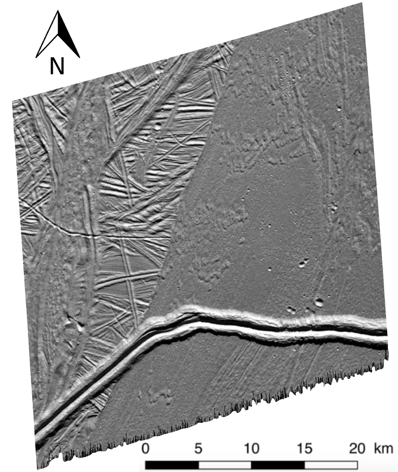
Figure 1: Gal
ileo SSI image 0526r that shows objects at different scales and clear shadows is adapted to test the robustness of the method
We used sfs, from NASA Ames Stereo Pipeline [1] in the photoclinometry mode only to estimate local topography. It starts from an initialization of the digital elevation model h0(x, y) and uses the light intensity variations I(h(x, y)) to estimate local slopes, considering a uniform surface photometric behavior (often Hapke model in planetology, hidden in the function in R in the cost function). Topography is then estimated iteratively minimizing the following cost function :

where h(x, y) describes the local topography, h0 (x, y) is the initialization for the topography, I (h(x, y)) is measured intensity interpolated at pixels obtained by projecting into the camera 3D points from the terrain h(x, y), T is the image exposure, A is the albedo, R (h (x, y)) is the reflectance, and μ and λ are two tuning coefficients controlling respectively the smoothness and the initialization weight [3]. The algorithm stops when a tolerance parameter is satisfied, meaning it has converged.
In our methodology, as we have no initial information, the algorithm is initialized as perfectly flat, of elevation 0, and the parameter λ that penalizes getting too far from the initialization is put to 0 (no penalization). The influence of the remaining tuning smoothness parameter µ is evaluated generating various DEM of the same area for a wide range of µ. Figure 2 shows an estimation of local elevation that is consistent with the cast shadows of various objects in image 0526r. The smoothness coefficient µ used in this case was 1.6, and the Hapke photometric model was used with the following parameters: ω=0.9, b=0.35, c=0.65, B0=0.5, h=0.6 [4].
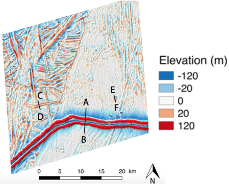
Figure 2: Estimated DEM for image 0526r (from [3]), using only photoclinometry.
The topographic profiles AB, CD and DE in figure 2 were selected (i) to evaluate the consistency of the DEM evaluation with cast shadows at three different scales and (ii) to test the influence of µ at theses different levels. With µ=1.6, the DEM is consistent with cast shadows at every scale. Figure 3 shows the influence of µ on three topographic profiles. Low values seem to uniformize the height distribution: larger objects appear the same size as the smallest. Large values may exaggerate the local topography, or on the contrary smooth completely the area. We found that the coefficient µ must be tuned specifically for each image, as its influence depends on the dynamics of the data. The influence of model parameters has also been studied, and three different photometric models have been tested: Hapke, LunarLambert, and Lambertian. For each model, uncertainties on their parameters (such as albedo, backscattering fraction etc) have been propagated. All parameters considered, we showed an uncertainty under 10% for the estimation of volumes of the small objects we were interested in.
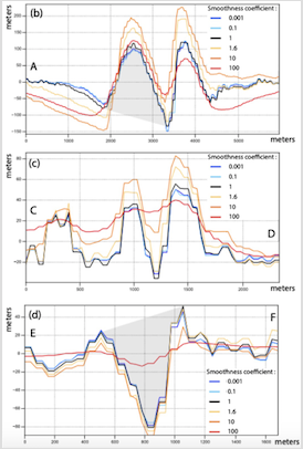
Figure 3: Estimated DEM on three topographic profiles from image 0526r (from [3]) using various smoothness parameters µ.
We tested the robustness of photoclinometry alone to evaluate volumes of planetary objects. We propagated uncertainties both from tuning and model parameters to the final results. We showed that when other techniques are not available volumes can be evaluated with a 10% error.
Acknowledgements
We acknowledge support from the “Institut National des Sciences de l’Univers” (INSU), the "Centre National de la Recherche Scientifique" (CNRS) and "Centre National d’Etudes Spatiales" (CNES) through the "Programme National de Planétologie »
References
[1] Beyer, R. A., Alexandrov, O., McMichael, S., 2018. The ames stereo pipeline: NASA's open source software for deriving and processing terrain data. Earth and Space Science 5
[2] Lesage, E., Massol, H., Schmidt, F., 2020. Cryomagma ascent on europa. Icarus 335, 113369.
[3] Lesage, E., Schmidt, F., Andrieu, F, Massol, H., 2020. Constraints on effusive cryovolcanic eruptions on Europa using topography from Galileo images, Icarus, in revisions
[4] Belgacem, I., Schmidt, F., Jonniaux, G., mar 2020. Regional study of europa’s photometry. Icarus 338, 113525.
How to cite: Andrieu, F., Lesage, E., Schmidt, F., and Massol, H.: DEM of Europa using photoclinometry only, Europlanet Science Congress 2020, online, 21 Sep–9 Oct 2020, EPSC2020-1123, https://doi.org/10.5194/epsc2020-1123, 2020.