
Geologic Investigation of a Debris-covered Mountain Glacier in Argyre Basin, Mars: Implications for Past Climate and History of Non-Polar Ice
 1,2
1,2- 1Birkbeck, University of London, Earth and Planetary Sciences, London, United Kingdom
- 2University College London (UCL), London, UK
- 3Sogetrel Telecommunications, Nancy, France
Introduction: Glacier-like forms (GLFs) are a particular class of ice-rich landforms that occupies the mid-latitudes of Mars [e.g., 1–4]. They appear to be concentrated around the 40º–55º latitude range in both hemispheres [3,4]. Here we present results from an ongoing geological investigation of what we interpret to be a debris-covered mountain glacier in the Argyre basin. The glacier system displays 1) multi piedmont-like terminal lobes, 2) gullied cirque-like source regions, 3) flows reaching ~35 km with an elevation drop reaching nearly 2 km from source to terminus, and 4) periglacial modification of surface materials indicative of near-surface ice. A better characterisation of this landform may provide clues regarding the formation and evolution of non-polar ice on Mars, particularly during periods of high obliquity.
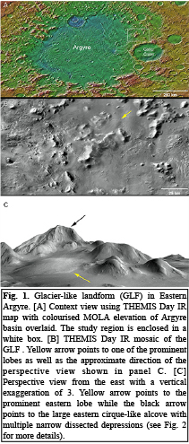
Geologic Setting: The glacier is located along the inner eastern rim of Argyre basin (Fig. 1), which suggests that the hosting mountain is an erosional remnant of the basin’s rim materials [e.g., 5]. The mountain has an elevation of ~3250 m and rises ~4250 m above the surrounding terrains to the east, and more than 6000 m above the Argyre floor to the west. It displays a wide mesa-like flat top more than 20 km across along its longest axis with steep (22–30°) sides that have developed into cirque-like alcoves. Two prominent alcoves face NE and NW and their walls are highly dissected by narrow depressions resembling gullies. The mountain displays 3 distinct lobes that appear to flow from the base of the cirques trending NE, NW, and SW, among other minor flows, while a lobate debris apron extends to the SE.
Observations: We created a CTX mosaic for the study region and georeferenced it to an HRSC DTM to extract morphometric information on flow directions and influence of surrounding topography, and complemented this with a morphologic investigation using HiRISE images.
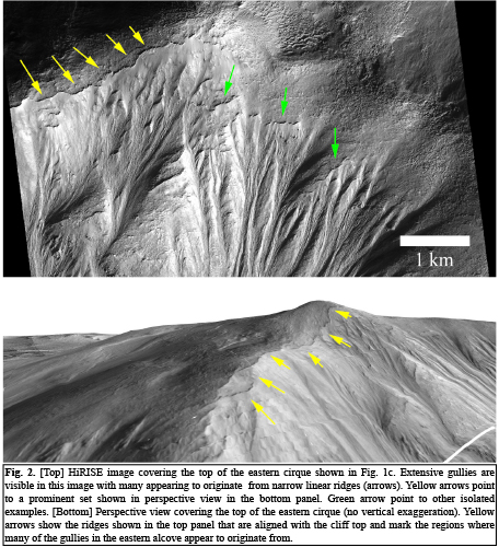
Paleo-accumulation regions: The source region for many of the flows appears to be the central mountain. Near the top, large cirque-like structures are visible that show extensive networks of gullies of variable widths and cross cutting relationships suggesting multiple, and varying, erosion cycles through time. Many of the drainage systems appear to originate from quasi-linear ridges, which are closely aligned with each other at the top of the mound (Fig. 2). We interpret these ridges to be the paleo-boundaries between the drainage systems and past ice-rich deposits at the mountain top, which contributed to the drainage systems.
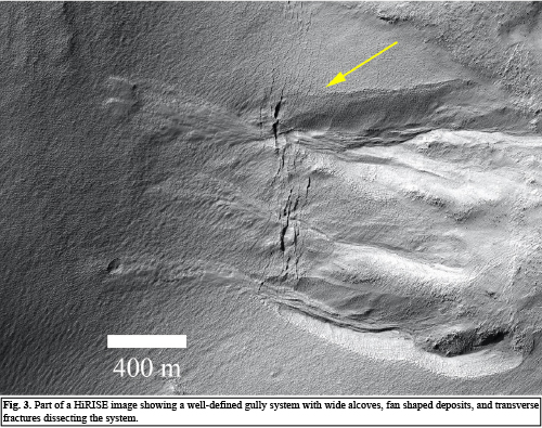
Fractures and gullies: On the western slopes of the central mountain, a number of distinctive gullies show deep alcoves, terminal fan-shaped deposits, and transverse fractures that cut through the gully system (Fig. 3). This type of transverse fractures that are quasi normal to the general slope suggest long-term modification following the gullies formation, which could be a result of periglacial modification, volatile loss, slowly flowing ice, or a combination of these processes.
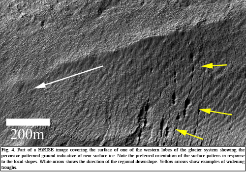
Surface periglacial modification: High resolution images covering multiple locations in the glacier system show that the surface is pervasively modified showing patterned grounds, which we interpret to be seasonal thermal contraction polygons. In areas of pronounced slopes, surface patterns appear to be additionally aligned with these slopes with fractures that are transverse to the slope direction showing preferential widening. Such locations are likely preferential zones for volatile loss. In certain cases, the fractures widen to create wide troughs (Fig. 4). We plan to present these findings, among others, in the meeting in more detail and discuss their possible implications.
References: [1] Arfstrom, J., and Hartmann, W.K., (2005), Icarus, 174, 321–335. [2] Head. J.W. et al. (2010), EPSL, 294, 306–320. [3] Souness, C. et al. (2012). Icarus, 217, 243–255. [4] Hubbard, B. et al. (2014), Cryosphere, 8, 2047–2061. [5] Dohm, J.M. et al. (2015), Icarus, 253, 66–98.
How to cite: El-Maarry, M. R. and Diot, X.: Geologic Investigation of a Debris-covered Mountain Glacier in Argyre Basin, Mars: Implications for Past Climate and History of Non-Polar Ice, Europlanet Science Congress 2020, online, 21 September–9 Oct 2020, EPSC2020-222, https://doi.org/10.5194/epsc2020-222, 2020