
Topographic correction of HiRISE and CaSSIS images: validation and application to multi-band photometry of Martian recurring slope lineae
 1,2,2,2,2,2
- 1University of Padova, Department of Physics and Astronomy, Padova, Italy (giovanni.munaretto.1@phd.unipd.it)
- 2INAF, Osservatorio Astronomico di Padova, Padova, Italy
Introduction
The topographic correction of satellite images has to be applied to both disentangle albedo features from illumination effects induced by local topography and to perform thorough spectrophotometric analyses of planetary surfaces. This abstract focuses on the modelling and removal of surface brightness variations induced by topography, referred as topographic shading, from high-resolution visible images of Mars. We validate our method and report scientific applications to both single and multi-band datasets by analyzing High Resolution Imaging Science Experiment (HiRISE, [1]) colour observations of Martian recurring slope lineae (RSL, [2] ) and dust devil tracks [3] and Colour and Surface Science Imaging System (CaSSIS,[4]) panchromatic observations.
Data and methods
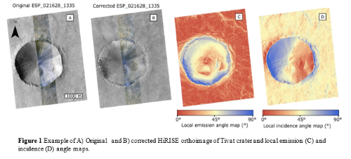
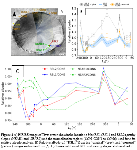
We initially apply the topographic correction (i.e. modeling and removal of topographic shading) to HiRISE images of Tivat Crater (-45.9°N, 9.5°E, Fig. 1A), Mars. This site hosts RSL (i.e. dark linear features that appear in warm season, fade in cold ones and recur annually) and dust-devil tracks (i.e. low-albedo tracks left by turbulent whirlwinds). Both features show a different albedo from nearby surfaces, representing an interesting scientific application of our method. In addition, relative photometry of Tivat crater’s RSL with respect to a “normalization” region having their same illumination and observation conditions (Fig. 2A) was recently published [5], offering us a benchmark for validating our method. All available HiRISE orthoimages of Tivat crater were radiometrically calibrated and atmospherically corrected with the dark pixel method, as in [5]. For each image, we followed the approach of [6] to compute local incidence and emission angle maps from the HiRISE DTM of the selected site. These maps were used to correct the image through the Lambert [6], Lommel-Seeliger [7], Akimov [8] and Minnaert [9] disk functions. The one returning the most uniform brightness values was selected for the photometric analysis. An example correction is shown in Fig. (1). We repeated the relative albedo analysis of [5] using both the original and corrected images. While with original images, affected by topographic shading, we obtain different results, our measurements on the topographically corrected images (Fig. 2B) and the derived time evolution of the RSL and nearby regions relative albedo (Fig. 2C) are consistent with [5], hence validating our method.
Results: HiRISE and CaSSIS case studies
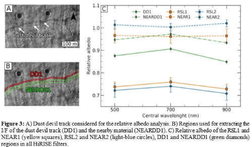
Multi-band photometry of RSL. We extended our method to the BG and NIR bands of HiRISE color orthoimages of Tivat crater. Our measurements in Fig. (3C) suggest that RSL are darker than nearby slopes but have the same colours within measurement uncertainties, in agreement with [2]. The same result also holds between RSL and the dust-devil tracks, hence possibly suggesting that RSL could be dust-removed features too.
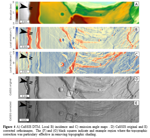
Topographic correction of CaSSIS panchromatic images. We corrected a CaSSIS panchromatic image depicting the north-eastern part of the Ascraeus Mons summit caldera complex (11.2°N, 255.9°E, Fig. 4C). Featuring a rich variety of slope orientations, this location represents a challenge for our method. The stereo observation of the site allowed the production of both DTM and orthoimages through the 3DPD photogrammetric pipeline [11]. These products, available through the Cassis DTM Repository [12], along with the computed local incidence and emission angle maps and the topographically corrected image are shown in Figure (4).
Conclusions
We presented and validated a method for removing topographic shading from HiRISE and CaSSIS images. We showed example applications by correcting HiRISE color datasets and a CaSSIS panchromatic image. The corrected images (Fig. 1,4) present a more uniform surface brightness, consistent with the removal of topographic shading. Corrected HiRISE color observation of RSL and dust-devil tracks allowed to investigate and compare the photometric properties of these features in all the HiRISE bands. The full methodology and scientific analyses of these datasets will be presented and discussed at the conference.
Acknowledgments: The authors wish to thank the spacecraft and instrument engineering teams for the successful completion of the instrument. CaSSIS is a project of the University of Bern and funded through the Swiss Space Office via ESA’s PRODEX programme. The instrument hardware development was also supported by the Italian Space Agency (ASI) (ASI – INAF agreement no. I/018/12/0), INAF/Astronomical Observatory of Padova, and the Space Research Center (CBK) in Warsaw. Support from SGF (Budapest), the University of Arizona (Lunar and Planetary Lab.) and NASA are also gratefully acknowledged. The study has been supported by the Italian Space Agency (ASI-INAF agreement no. 525 2017-03-17).
References
[1] A. S. McEwen et al. (2007), JGR:Planets
[2] A. S. McEwen et al. (2011), Science
[3] D. Reiss et al. (2016), SSR
[4] N. Thomas et al. (2017), SSR
[5] E. I. Schaefer et al. (2019), Icarus, 317,621–648
[6] B. Hapke, Theory of reflectance and emittance spectroscopy,1993
[7] M. B. Fairbairn (2005), \jrasc,99,3,92
[8] S. E. Schröder et al. (2013), PSS,85,198–213
[9] M. Minnaert (1941),Astrophys. J., 93,403–410
[10] P. K. Byrne et al. (2012), JGR:Planets
[11] E. Simioni et al. (2017), Int. Arch. Photogramm. Remote Sens. Spat. Inf. Sci.,vol. XLII-3/W1,133–139
[12] G. Cremonese and C. Re (2018), EPSC2018-1236.
How to cite: Munaretto, G., Pajola, M., Lucchetti, A., Re, C., Cremonese, G., Simioni, E., and Cambianica, P.: Topographic correction of HiRISE and CaSSIS images: validation and application to multi-band photometry of Martian recurring slope lineae, Europlanet Science Congress 2020, online, 21 Sep–9 Oct 2020, EPSC2020-328, https://doi.org/10.5194/epsc2020-328, 2020.