Kuiper Quadrangle spectral analysis: looking forward to integrated geological map
- 1INAF-IAPS, Rome, Italy
- 2CISAS “G.Colombo”, Università degli Studi di Padova, Padua, Italy
- 3Dipartimento di Geoscienze, Università degli Studi di Padova, Padua, Italy
- 4DISTAR, Università degli Studi di Napoli Federico II, Naples, Italy
- 5Dipartimento di Scienze & Tecnologie, Università degli Studi di Napoli ‘Parthenope’, Naples, Italy.
Mercury geology reached a new era after the MESSENGER mission, which has allowed not only to acquire global information but also to study the geological history of the planet with multiple techniques. The orbital BepiColombo mission will be the next step to fix some of the Hermean paradigm because more techniques, coupled with the higher resolution of the instruments onboard Mio and Bepi.
Integration of compositional data and morpho-stratigraphic maps generally produced from camera data, will be one of the main issue to improve the understanding of Mercury geological evolution. This goal is also correlated with the efforts of other projects such as PLANMAP European H2020 and GMAP Europlanet 20-24.
Several morpho-stratigraphic maps of Mercury quadrangles have been produced, or are ongoing (e.g. Galluzzi et al. 2018), and a global map has been realized (e.g. Kinczyk et al. 2019). Discussion or integration at quadrangle level of Mercury is recently beginning (e.g. Bott et al. 2019; Zambon et al. 2019) and here we report activity done in the Kuiper H06.
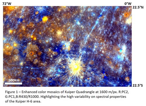
Kuiper (H06) is an equatorial quadrangle, and it encompasses the area between longitudes 72°W –0° and latitudes 22.5°N – 22.5°S. H06 morpho-stratigraphic mapping is still ongoing (Giacomini et al. 2018; 2019), it evidences a high variegation of units, from older intercrater plains to younger smooth plains, to craters. Several craters show pyroclastic deposits (e.g. Kerber et al. 2011; Pajola et al. 2020), in some cases with putative vents, and hollows. Some of the hollows look like very peculiar from spectral point of view, e.g. in Dominici Crater (Vilas et al. 2016; Lucchetti et al. 2018), showing possible indication of mineralogical phases. Whereas most smooth plains are limited in extension and confined on the floor of the largest craters, a wide smooth plain has been detected that surrounds Rudaki crater. Some of these plains show clearly color variegation (e.g. two color units within Renoir Basin, see Giacomini et al. 2018).
Due to the low latitudes, the coverage from MDIS data with high spatial resolution is lower than the northern quadrangles (e.g. Bott et al. 2019; Zambon et al. 2019) and we approach the study in a multiple-stage passages. This has been done to investigate the region with the best detail from a spectral point of view. Following the mosaic product procedure used by Zambon et al. (2019), we generate a homogeneous 8 color global mosaic at 1600 m/px scale (average scale taking into account the average resolution) and at 665 m/px pushing the resolution. Moreover, we considered the partial quadrangle coverage mosaics at 385 m/px and 246 m/px to exploit the presence of higher resolution color images.
We will show spectral variations considering specific indices and color combinations (example on Figure 1), discussing the possibility to define some spectral units which could be later integrated with the morpho-stratigraphic mapping. Furthermore, we will locally investigate the spectral variation of specific cases, e.g. fresh craters, hollows and pyroclastic material, to infer some indication on material composition, or within some blue dark regions to understand the possible darkening material.
This activity could be also helpful in the definition of indicators improving the selection procedure for regions of interest (see also Giacomini et al. 2020) to be studied for covering the science goals of the BepiColombo mission (e.g. Rothery et al. 2020).

Acknowledgements:
We gratefully acknowledge funding from the Italian Space Agency (ASI) under ASI-INAF agreement 2017-47-H.0. MM, CC, FZ, FA were also supported by European Union’s Horizon 2020 research grant agreement No 776276- PLANMAP. MM, CC, FA were also supported by Europlanet 20-24 GMAP, EPN-RI-2024.
References:
Bott N., et al. 2019. Global Spectral Properties and Lithology of Mercury: The Example of the Shakespeare (H‐03) Quadrangle. JGR-Planets, 124, 2326-2346.
Zambon F., et al. 2019. Spectral properties of the H05 Hokusai quadrangle on Mercury and relationship with the morpho-stratigraphic units. EGU 7796.
Giacomini L., et al. 2018. Updates on geologic mapping of Kuiper (H06) quadrangle. EPSC 721-1.
Giacomini L., et al. 2019. GEOLOGICAL MAPPING OF THE KUIPER (H06) QUADRANGLE OF MERCURY. XV Congresso delle Scienze Planetarie, pg. 71.
Giacomini L., et al. 2020. Scientific sites of interest in Kuiper Quadrangle (H06). EPSC this meeting.
Kerber L., et al. 2011. The global distribution of pyroclastic deposits on Mercury: The view from MESSENGER flybys 1–3. PSS, 59, 1895–1909.
Kinczyk M.J., et al. 2019. The First Global Geological Map of Mercury. EPSC-DPS 1045-1.
Lucchetti A., et al. 2018. Mercury Hollows as Remnants of Original Bedrock Materials and Devolatilization Processes: A Spectral Clustering and Geomorphological Analysis. JGR-Planets, 123, 2365-2379.
Pajola M., et al. 2020. MULTIDISCIPLINARY ANALYSIS OF LERMONTOV CRATER ON MERCURY. 51 LPSC 1402.
Rothery et al. 2020. Rationale for BepiColombo studies of Mercury’s surface and composition. Spa.Sci.Review. in press.
Vilas F., et al. 2016. Mineralogical indicators of Mercury's hollows composition in MESSENGER color observations. JGR 43, 1450-1456.
How to cite: Carli, C., Giacomini, L., Zambon, F., Ferrari, S., Massironi, M., Galluzzi, V., Altieri, F., Capaccioni, F., Ferranti, L., and Palumbo, P.: Kuiper Quadrangle spectral analysis: looking forward to integrated geological map, Europlanet Science Congress 2020, online, 21 Sep–9 Oct 2020, EPSC2020-367, https://doi.org/10.5194/epsc2020-367, 2020.

