- 1Geography Department, Dawson College, Montreal, Qc, Canada
- 2Laboratoire de Planétologie et Géodynamique, UMR, CNRS 6112, 2 rue de la Houssinière, 44322, Nantes, Cedex 3, France
- 3Earth, Planetary and Space Sciences, University of California, Los Angeles, CA, USA
- 4School of Natural Sciences, Trinity College Dublin, Ireland, Dublin 4, Ireland
- 5Centre for Northern Studies, Laval University, Quebec City, Qc, Canada
- 6Ocean Wise, PO Box 3232, Vancouver, BC, Canada
Introduction
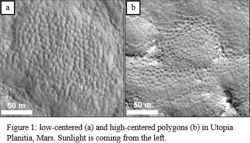
On Mars, polygonally patterned ground is widespread at the mid to high latitudes and it is accepted to result from thermal contraction of ice-cemented soil1. Low-centered polygons (LCPs), i.e. polygons with a relatively lower elevation at their centre (Figure 1a), and high-centered polygons (HCPs), i.e. polygons with a relatively higher elevation at their centre (Figure 1b), can be observed at the martian mid latitudes2.
On Earth, ice-wedge polygons are morphologies that are formed when ice aggrades on a seasonal basis in thermal contraction cracks in ice-cemented soil3. This aggradation uplifts the sediment at the polygon margins forming LCPs. When ice-wedge polygons degrade as mean seasonal temperatures rise, the melting of the ice in the wedges drops the elevation at the polygon margins, forming HCPs3.
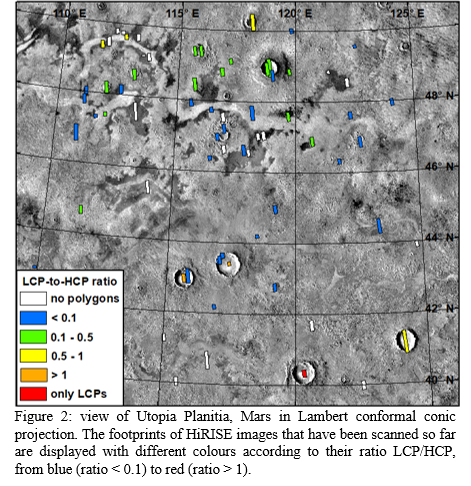
Both LCPs and HCPs can also be formed when the wedge-material is wind-blown sand, rather than ice; however, were the wedges comprised of sand a variance in morphology based on a change of latitude would not be expected since in this case the type of polygon expressed should not depend on the ambient thermal conditions. Therefore, based on the assumption that ground ice stability increases poleward on Mars4, we hypothesise that the relative abundance of LCPs compared to HCPs should increase with latitude if these polygons are a result of ice wedges rather than sand wedges. We test this hypothesis in a region of Utopia Planitia (Figure 2), where there is good coverage of high-resolution images sufficient to distinguish LCPs from HCPs and the widespread occurrence of polygonally patterned ground5.
Method
We used 73 High Resolution Imaging Science Experiment (HiRISE) images at 25-50 cm/px over the Utopia Planitia study region (Figure 2). 59 images remain to be analysed for a total of 132. The study area was divided into squares of 250,000 km², and for each one the presence or absence of LCPs and HCPs in the images was noted – where there were overlapping images only the highest quality image was assessed. At least five LCP- or HCP-type polygons must occur per square for their presence to be noted. Images were divided into two groups: the ones whose resolution/quality allows unambiguous identification of LCPs and/or HCPs when present (47 images, 29 with polygons), and the ones where identification was more challenging (26 images, 20 with polygons) e.g. because of low resolution, small polygon sizes, poor contrast, and/or atmospheric haze. Three further images were of insufficient quality for analysis. We distinguished two types of host terrain: “craters” (≥ 2 km diameter) and inter-crater plains. Finally, the ratio of the number of LCPs to the number of HCPs was calculated for each degree of latitude for both terrain types, and also for each image.
Results
We compared the data from the low resolution/quality images to the higher resolution/quality images and found the same latitudinal trends in the LCP-to-HCP ratio. We therefore considered these images as having reliable data, and results from both groups are reported in the subsequent analysis. In Figure 2 we show the LCP-to-HCP ratio per HiRISE image, however below and in Figure 3 we report the LCP-to-HCP ratio calculated for every 1° of latitude no matter which image they fall within.
If the LCP-to-HCP ratio is plotted for the polygons in craters and on the plains separately, polygons located on the inter-crater plains show a strong correlation between latitude and LCP-to-HCP ratio (R² ≈ 0.86, p-value ≈ 0.0003; Figure 3). Note that the LCP-to-HCP ratio is nearly always higher in craters than it is on the plains particularly at lower latitudes. However, no latitudinal trends are observable in the LCP-to-HCP ratio for polygons in craters (R² ≈ 0.12; Figure 3). Note that the extreme value of 6 in the LCP-to-HCP ratio at 40°N originates from two 30-40 km craters in which LCPs are very common and at this latitude no other HiRISE image with polygons has been found. When the data are analysed as an ensemble (i.e. the host terrain type is not taken into account), we find no correlation between latitude and LCP-to-HCP ratio (R² ≈ 0.28).
Conclusions
- polygons located on the plains in Utopia Planitia show a positive correlation between latitude and LCP-to-HCP ratio that is statistically strong. This provides evidence in support of the hypothesis that these polygons have ice-wedges at their margins whose degradation increases towards the equator1.
- the LCP-to-HCP ratio of polygons inside craters does not show any trend with latitude. We suggest that the micro-environment inside the crater could protect the ice-wedges from degradation: craters could form cold traps where volatiles are preferentially preserved6. This is supported by the higher LCP-to-HCP ratio in craters compared to the plains and the occurrence of polygons in craters to lower latitudes than on the surrounding plains. Our next step will be to examine the other factors that could influence the type of polygon that occurs inside craters, including elevation, crater diameter and preservation state.


References
1Mellon M.T. (1997) J. Geophys. Res. 102 (E11), 25,617–25,628.
2Soare R.J. et al. (2018) Chapter 7, in, Dynamic Mars, recent landscape evolution of the red planet, eds. Soare, R.J., Conway, S.J. and Clifford, S.M., Elsevier, 464 p.
3Lachenbruch A.H. (1962) GSA Special Paper 70. vol. 69 Geological Society of America, New York.
4Schorghofer N., Forget, F. (2012) Icarus 220, 1112-1120.
5Soare R.J. et al. (2020) Icarus 342, 113233.
6Conway S.J. et al. (2012) Icarus 220, 174-193.
How to cite: Soare, R. J., Philippe, M., Conway, S. J., Williams, J.-P., Mc Keown, L. E., Godin, E., and Hawkswell, J.: Possible ice-wedge polygonisation in Utopia Planitia, Mars and its poleward gradient of latitude, Europlanet Science Congress 2020, online, 21 Sep–9 Oct 2020, EPSC2020-385, https://doi.org/10.5194/epsc2020-385, 2020.

