- 1Jet Propulsion Laboratory, Planetary Science, United States of America (alena.probst@jpl.nasa.gov)
- 2Independent Consultant
- 3Aix Marseille Univ, CNRS, CNES, LAM, Marseille, France
- 4Goddard Space Flight Center, NASA, Greenbelt, MD
In-situ probe measurements of planetary atmospheres add an immense value to remote sensing observations from orbiting spacecraft or telescopes, as highlighted and justified in numerous publications [1,2,3]. Certain key measurements such as the determination of noble gas abundances and isotope ratios can only be made in situ by atmospheric entry probes, but represent essential knowledge for investigating the formation history of the solar system as well as the formation and evolutionary processes of planetary atmospheres. Following the above rationale, a planetary entry mission to one of the outer planets (Saturn, Uranus and Neptune) has been identified as a mission of high priority by international space agencies. In the last Planetary Science Decadal Survey, a Uranus probe/orbiter was the highest priority for a future flagship Mission.
Within the scientific frame of atmospheric planetary sciences, a two- to three-year research study called IPED (Impact of the Probe Entry Zone on the Trajectory and Probe Design) investigates the impact of the interplanetary and approach trajectories on the feasible range of atmospheric entry sites as well as the probe design, considering Saturn, Uranus and Neptune as target bodies. The objective is to provide a decision matrix for entry site selection by comparing several mission scenarios for different science cases.
This talk introduces a tool development that focuses on the approach circumstances of a planetary entry probe upon arrival depending on science objectives of the entry sites. Science objectives are organised in four (planetocentric) latitude ranges: (1) low latitudes ‹15°, (2) mid latitudes between 15° and 45°, (3) high latitudes between 45° and 75° and (4) polar latitudes of ›75°. The latitude ranges are considered as potential entry zones for the IPED tool implementation. The final tool will allow mission designers and scientists to determine accessible entry sites (or regions) of a planet by using the hyperbolic entry velocity (direction, declination and absolute value) and the altitude of the entry interface point.
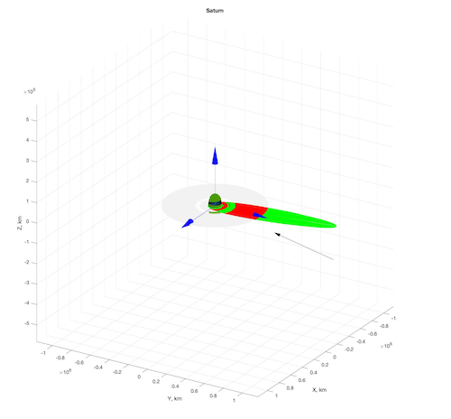
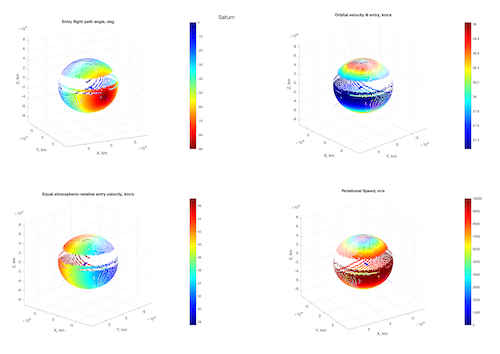
The IPED tool enables a 3D visualization of accessible / non-accessible latitudes depending on the range of selected parameters such as the flight path angle and the probe velocity at atmospheric entry, as well as environmental conditions of the destination planet such as the planet’s ring geometry and obliquity. The talk will present the status of work and first results, examples of which are displayed in the following figures for the planet Saturn for a case of a hyperbolic incoming velocity of v∞ = 12.06 km/s and an entry altitude of 700 km. Figure 1 shows the 3D overview of the planet’s system, with the black arrow representing the direction of approach asymptote of a probe trajectory aiming for the centre of gravity (flight path angle @ entry = 90°) and the shaded grey area being the ring structure of the planet. Variations of the B-plane vector and clock-angle result in a set of entry trajectories impact locations in the planet’s atmosphere are represented in dark green on the planet’s sphere. The trajectories are tested for safe ring crossing before impact (red points = unsafe, green points = safe). Unsafe trajectories are blocked and not considered in the evaluation. Figure 2 evaluates all entry points (dark green points in Figure 1) for specific characteristics at entry, mainly the flight path angle, the orbital and equal atmospheric relative velocity and the rotational speed of the planet at that latitude. The final development goal is a tool that allows a comparison of data based on different trajectories and approach asymptotes, launch windows and restrictions imposed by the probe design, such as limits on the flight path angle or entry velocity. The necessary development steps will be explained and discussed.
The presented research was supported by an appointment to the NASA Postdoctoral Program (NPP) at the Jet Propulsion Laboratory (JPL), California Institute of Technology, administered by Universities Space Research Association (USRA) under contract with National Aeronautics and Space Association (NASA). © 2020 All rights reserved.
[1] Mousis, O. et al., Scientific Rationale for Saturn’s in situ exploration, Planetary and Space Science 104 (2014) 29-47.
[2] Mousis, O. et al., Scientific Rationale for Uranus and Neptune in situ explorations, Planetary and Space Science 155 (2018) 12-40.
[3] Hofstadter, M. et al., Uranus and Neptune missions: A study in advance of the next planetary science decadal survey, Planetary and Space Science 177 (2019) 104680.

Figure 1 - 3D Overview on the evaluation space: The Saturn’s ring structure is displayed in grey, the body inertial reference frame as blue arrows, the asymptote of the incoming hyperbolic velocity as a black arrow, plane crossing trajectories in green (safe) and unsafe (red) and atmospheric entry locations in dark green.

Figure 2 – Evaluation of all entry points (dark green points in Figure 1) for characteristics and their variation over the latitude / longitude at atmospheric entry at 700 km altitude: the flight path angle (upper left corner), the orbital velocity (upper right corner), equal atmospheric relative velocity (lower left corner) and the rotational speed of the planet (lower right corner).
How to cite: Probst, A., Spilker, L., Spilker, T., Atkinson, D., Mousis, O., Hofstadter, M., and Simon, A.: Assessing the Accessibility of different Latitudes for Planetary Entry Probe Missions to Saturn, Uranus and Neptune, Europlanet Science Congress 2020, online, 21 Sep–9 Oct 2020, EPSC2020-435, https://doi.org/10.5194/epsc2020-435, 2020.

