
 1
1- 1Lunar and Planetary Institute/USRA (schenk@lpi.usra.edu)
- 2Washington University in Saint Louis
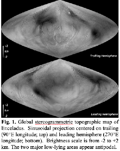
Cassini observations have led to several efforts to map the global topography of Enceladus [1-5]. The most prominent large-scale features include 100+ km scale basins (1), and the depressed south polar terrain (SPT) [2]. Here we present a revised and complete stereogrammetric map of Enceladus topography at 0.4-km scales (Fig. 1) including the north polar regions mapped at the end of the mission and that does not require interpolation. We reevaluate the distribution and origin of large-scale topographic deviations and compare north and south polar regions.
Stereogrammetric digital elevation models (DEMs) of Enceladus were constructed from Cassini stereo pairs and mosaics using the same software used to map the topography of Pluto, Charon, and other icy bodies [6]. As each stereo pairing has a unique stereo geometry, the vertical precision (or uncertainty) is variable across Enceladus and ranges from <50 to ~300 m. Hence while most DEMs resolve geologic features, a few do not. The individual stereo-DEMs are assembled into a global DEM (Fig. 1) by minimizing the difference to our (coarser but coincident) map of 4591 match point radii values. Our new map shows topography relative to the triaxial ellipsoid of [2]. Here we focus on global and regional variations and defer analyses of geologic features.
Schenk and McKinnon [1] discovered several oval-shaped depressions on the trailing hemisphere circa 150-km across and 1-1.5 km deep in their partial DEM. They found an isostatic explanation for these depressions to be most physically plausible, and concluded that basins could be sites of cold, dense, immobile (or downwelling), partially clathrated ice, or alternatively, manifestations of deeper convective upwellings (and porosity reduction), either now or in the past. Tajeddine et al. [4] extended the global topography map through a spherical harmonic representation (to degree 16) based on both limb profiles [2] and stereogrammetric control points, and reported that additional depressions occurred on the remaining surface and that some formed an apparent great circle; [4] further suggested the circle was offset due to true polar wander (TPW). Our new map is much denser in terms of stereo-derived elevations, yielding ~5.2×10⁶ measurements, spaced every 0.4 km or so. We find that Enceladus’ surface topographic signature is both complex and subtle. Contrary to our expectations [1], no additional deep basins similar to those reported by [1] occur in the leading hemisphere.
Without these basins the case for a great circle alignment (and by extension any TPW implied) is weakened. We also note that the average ice shell thickness of ~20-25 km implied by Enceladus’ libration [7] does not easily support a convective origin for the “E basins” proposed by [4]; the present-day shell is too thin [cf. 8].
The circular resurfaced zone that dominates the leading hemisphere [9] has a warped signature suggestive of large rounded polygons separated by elongate depressions. Some of the highest elevations occur in the southern part of this resurfaced zone. The topographic signature of the trailing hemisphere zone is different again. Neither exhibit the concentric rings that might be expected from topographic relaxation or thickening of a region similar to the current depressed SPT, if they were once active in a similar way and ceased thermal activity. The two resurfaced zones may have responded differently to regional stresses than the older cratered terrains between them.

2. North vs. South Polar Terrains
A fundamental characteristic of Enceladus is that the SPT is vigorously resurfacing and active but the cratered northern polar terrains (NPT) are not despite models that show similar tidal heating at both poles [10]. The NPT were the last areas to be mapped by Cassini. Our global DEM confirms that the SPT (>70°S) is depressed ~400 m relative to the best-fit ellipsoid (confirming [2]), but the NPT (>70°N) are elevated ~0.7 km above. The north polar imaging confirms that tectonic features with fresh blue-ice signatures do cross the NPT. The apparent broad doming of the NPT might suggest that either the ice shell is relatively thick there (and perhaps more resistant to tidal heating relative to the original southern terrain) or that incipient resurfacing is preceded by doming before the crustal replacement cycle begins.
3. Global Aspects and Conclusions
A global hypsogram of Enceladus (Fig. 2) using our new complete DEM (Fig. 1) shows that global topographic deviations from the first-order triaxial ellipsoid [2] are at the 95th percentile within ±1 km of the triaxial ellipsoid, confirming earlier incomplete maps [1,4]. Two ‘humps’ can be identified in the hypsogram at -0.4 km (representing the SPT) and at -1 km (representing the basins). This is possibly the narrowest global topographic signature in the Solar System for an ellipsoidal body [11], although it might be matched by Europa, Ganymede and Triton (work in progress), and is consistent with expected subdued topography of an active icy ocean world. The preservation of the deep 1-1.5 km deep basins is an unsolved problem [1,3], but might reflect patterns of heat flow from the core [12]. Enceladus’ topographic signature is complicated, with indications that older cratered terrains and the three younger resurfaced terrains responded differently to stresses. The distribution of large deep basins is enigmatic, and although they do not form a great circle, lower-lying topography is more prevalent at mid-northern latitudes. More complete analyses of higher harmonics are underway and may yield additional insights.
References
[1] Schenk, P., and McKinnon, W., GRL 36, L16202, 2009.
[2] Thomas, P.C, et al., Icarus 190, 573–584, 2007.
[3] Nimmo, F., et al., JGR 116, E11001, 2011.
[4] Tajeddine, R., et al., Icarus 295, 46-60, 2017.
[5] Bland, M., et al., 4th Planetary Data Workshop, abs. #7048, 2019.
[6]. Schenk, P.M., et al., Icarus, 314, 400-433, 2018a.
[7] Thomas, P.C, et al., Icarus 264, 37-47, 2016.
[8] Barr A.C., and McKinnon, W.B., GRL 34, L09202, 2007.
[9]. Crow-Willard, E., R. Pappalardo, JGR., 120, 928-950.
[10] Nimmo, F., et al., in Enceladus and the Icy Moons of Saturn, UA Press, pp. 79-94, 2018.
[11] Schenk, P., et al., in Enceladus and the Icy Moons of Saturn, UA Press, pp. 237-265, 2018.
[12] Čadek, O., et al., Icarus 319, 476-484, 2019.
How to cite: Schenk, P. and McKinnon, W.: Global Topography of Enceladus: North-Pole-South-Pole, Deep Basins and TPW Revisited, Europlanet Science Congress 2020, online, 21 Sep–9 Oct 2020, EPSC2020-497, https://doi.org/10.5194/epsc2020-497, 2020.