
VISAR: Taking A Fresh Look at the Surface of Venus
 1,
1,- 1Jet Propulsion Laboratory, Radar Science and Engineering, Pasadena, United States of America (scott.hensley@jpl.nasa.gov)
- 2Center for Earth and Planetary Studies, Smithsonian National Air and Space Museum Washington D.C. USA
- 3University of La Sapienza, Rome, Italy
Abstract
Synthetic aperture radars provide the only viable means for obtaining high resolution images of the surface of Venus. The NASA Magellan mission in the early 1990s obtained the best resolution imagery and topography of the surface of Venus and these data are the foundations for many of the scientific advances in Venus science in the last decades. Mixed with these new scientific insights gained with the Magellan data new questions have arisen and old fundamental questions like how did Venus and Earth evolve so differently require a fresh look at the surface of Venus. The Venus Interferometric Synthetic Aperture Radar (VISAR) is part of the proposed VERITAS mission, that would launch in 2026, and is designed to provide that fresh look and generate high resolution imagery and topography of the surface.
VERITAS is one of four candidate NASA Discovery 2019 missions being studied for an eventual NASA selection in the Spring of 2021. VERITAS would carry, VISAR an X-band interferometric radar provided by NASA/JPL with contributions from ASI and DLR. VISAR would operate from an orbit that is between 180 and 255 km in altitude at a look angle of 30˚.
During the roughly 16 orbits per day VISAR would collect data on both ascending and descending passes for 11 orbits and then the spacecraft is turned to Earth to downlink the acquired data. VERITAS plans to operate for 4 Venus sidereal days or cycles (243 days) and by shifting the downlink gaps between imaging cycles global coverage is possible.
VISAR design was motivated by two primary mission objectives, (1) to obtain global imagery of finer resolution than the Magellan radar and (2) to obtain global topographic measurements of comparable spatial resolution and accuracy available at other terrestrial bodies in the solar system. In order to obtain high accuracy uniform quality topographic data we selected single pass radar interferometry like that used by SRTM and Tandem-X to map the Earth [4], to provide the desired topography measurements. VISAR has been designed to achieve 5 m elevation accuracy with a spatial resolution of 250 m making it comparable to or better than terrestrial planet topography data except for the Earth.
VISAR is an X-band (7.9 GHz) vertical polarization single pass radar interferometer with two 3.9×0.6 m antennas separated by an interferometric baseline of 3.1 m as shown in Figure 1. The radar operates with a look angle of 30˚ which is balance between radar losses and minimizing shadow and layover gaps in the topographic data. Operating with a transmit bandwidth of 20 MHz VISAR has a range resolution of 7.5 m and has an azimuth resolution of 2.1 m. Radar imagery of 30 m spatial resolution with approximately 25 looks is acquired globally and magery with 15 m resolution and 7 looks is acquired for about 20% of the planet Radar interferograms with a spatial resolution of 250 m (a 125 m options is being studied) and 1800 looks are generated onboard to reduce data volume. Raw data can be downlinked to support repeat pass radar observations.

Figure 1. VISAR flight configuration and observing geometry are optimized for InSAR DEM acquisition with baseline separation B = 3.1 m.
The expected elevation mapping accuracy of the VISAR instrument is shown in Figure 2 based a comprehensive model to evaluate radar performance [5], [6]. The number of looks represents the number of observations from ascending and descending passes acquired over the 4 cycles. Backscatter contributions to SNR and attenuation losses are factored in the overall performance computation. Phase noise limited elevation accuracy (in blue) is compared to elevation accuracy before and after correcting for residual tilts and biases using radar tie points in overlapping image strips (red and green).
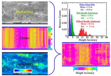
Figure 2. Performance model for VISAR shows that it has an elevation measurement accuracy of 5 m at 250 m spatial resolution.
VISAR would also collect repeat pass radar data for 12-15 targeted 200×200 km sites. Deformation accuracy is limited by atmospheric variations between observations, mostly due to SO2 variations, which at 50 m posting is about 1.5 cm. These data would be the first deformation interferometry at another planet.
VISAR is a proposed radar system that is leveraging advances in radar technology and imaging techniques in interferometry since Magellan to provide greatly improved data products for the study of Venus.
Acknowledgements
A portion of this research was conducted at the Jet Propulsion Laboratory, California Institute of Technology, under contract with National Aeronautics and Space Administration. The information presented about VERITAS is pre-decisional and is provided for planning and discussion purposes only.
References
[1] R. S. Saunders, et al, , Magellan Mission Summary. Journal of Geophysical Research, 97:13,06713,09, 1992.
[2] P. G. Ford and G. H. Pettengill, Venus Topography and Kilometer-Scale Slopes, J. Geophys. Res., 97, E8, 13,103-13,114 (1992).
[3] Leberl, F. W., Thomas, J. K., and Maurice. K. E., Initial Results From The Magellan Stereo Experiment, Journal of Geophysical Research, VOL. 97, NO. E8, pp. 13,675-13,689, August 25, 1992.
[4] Farr, T. G., Paul A. Rosen, Edward Caro, Robert Crippen, Riley Duren, Scott Hensley, Michael Kobrick, Mimi Paller, Ernesto Rodriguez, Ladislav Roth, David Seal, Scott Shaffer, Joanne Shimada, Jeffrey Umland, Marian Werner, Michael Oskin, Douglas Burbank, and Douglas Alsdorf, The Shuttle Radar Topography Mission, Rev. Geophys., 45, RG2004, 2007
[5] S. Hensley, J. Martin, S. Oveisgsharan, X. Duan, and B. A. Campbell, "Radar Performance Modeling for Venus," VEXAG Meeting, Applied Physics Laboratory, 2018.
[6] Scott Hensley, A Combined Methodology for SAR Interferometric and Stereometric Error Modeling, Radar Conference, 2008
How to cite: Hensley, S., Smrekar, S., Perkovic-Martin, D., Campbell, B., and Mastrogiuseppe, M.: VISAR: Taking A Fresh Look at the Surface of Venus, Europlanet Science Congress 2020, online, 21 September–9 Oct 2020, EPSC2020-513, https://doi.org/10.5194/epsc2020-513, 2020