
Sites of geological interest in Kuiper quadrangle (H06)
 1,1,1,1,2,
- 1INAF, Istituto di Astrofisica e Planetologia Spaziali, Rome, Italy (lorenza.giacomini@inaf.it)
- 2Dipartimento di Geoscienze, Università degli Studi di Padova, Padua, Italy
- 3DISTAR, Università degli Studi di Napoli Federico II, Naples, Italy
- 4Dipartimento di Scienze & Tecnologie, Università degli Studi di Napoli ‘Parthenope’, Naples, Italy
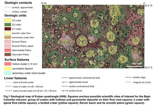
Kuiper quadrangle (H06) is located at the equatorial zone of Mercury and encompasses the area between longitudes 288°E – 360°E and latitudes 22.5°N – 22.5°S. A detailed geological map (1:3M scale) of the Kuiper quadrangle based on the high resolution MESSENGER data, was performed (Giacomini et al., 2018) (Fig.1).
The main basemap used for H06 mapping was the MDIS (Mercury Dual Imaging System) 166 m/pixel BDR (map-projected Basemap reduced Data Record) mosaic. Additional datasets were also taken into account, such as DLR stereo-DEM of the region (Preusker et al., 2017), mosaics with high-incidence illumination from the east and west, and MDIS global color mosaic (Denevi et al., 2018). The geological map showed that the quadrangle is characterized by a prevalence of crater materials which were distinguished into three classes based on their degradation degree (Galluzzi et al., 2016): from C1, consisting on the most degraded craters, to C3, including the freshest ones. Different plain units were also identified and classified on the basis of their density of craterisation: (i) intercrater plains, densely cratered, (ii) intermediate plains, moderately cratered and (iii) smooth plains, poorly cratered. Finally, several structures, mainly represented by thrusts, were mapped all over the quadrangle.
The mapping of quadrangle allowed the identification of canditate targets for the BepiColombo mission to Mercury (Fig.1). Indeed, volcanic features, as hollows and pyroclastic deposits, are widespread in the quadrangle. Their high-resolution analysis could give new information regarding the volcanism history on the planet.
Also several faulted craters have been detected. They represent important indicators to understand the kinematic of the structures transecting the craters (e.g. Galluzzi et al., 2015). Therefore, they will allow us to gain new clues on the tectonic history of the planet surface, with important implications for the knowledge of the thermophysical evolution of Mercury.
Further intriguing features are craters showing smooth ejecta with sinuous edges and a fluidized morphology. They have been called ejecta flows and they are thought to represent dry granular flows, although the presence of volatiles involved in the fluidization process can not be excluded (Xiao, 2013). Hence, high resolution data could give new inputs for the knowledge of the origin and evolution of these deposits.
Where MDIS WAC images at high spatial resolution are available, a more detailed analysis of the spectral behaviour of the surfaces can be accomplished (Carli et al., 2020). This allowed us to integrate geomorphological and spectral characteristics for specific areas in order to obtain new information about the landforms’ origin. Such procedure was preliminary conducted on Renoir basin, where two smooth deposits, showing different spectral characteristics, have been detected in different areas of its floor. However, a higher spectral and spatial resolution are needed to better appreciate the differences on those deposits.
In light of these evidences, it appears that the high resolution of the instruments of BepiColombo mission, like STC and HRIC cameras and VIHI spectrometer of SIMBIO-SYS, can significantly contribute to answer several questions raised during the geological mapping and analysis of the Kuiper quadrangle.
Acknowledgements
We gratefully acknowledge funding from the Italian Space Agency (ASI) under ASI-INAF agreement 2017-47-H.0. MM, CC, FZ were also supported by European Union’s Horizon 2020 research grant agreement No 776276- PLANMAP.
References
Carli et al., 2020. Kuiper Quadrangle spectral analysis: looking forward to integrated geological map. EPSC, this conference.
Denevi et al., 2018. Calibration, Projection, and Final Image Products of MESSENGER’s Mercury Dual Imaging System. Space. Sci. Rev., 214: 2. https://doi.org/10.1007/s11214-017-0440-y
Galluzzi et al., 2015. Faulted craters as kinematic indicators in planetary tectonics: application to Mercury. In: Volcanism and Tectonism across the Inner Solar System, vol 401. Geol.
Soc. London Spec. Pub, pp. 313–325.
Galluzzi et al., 2016. Geology of the Victoria quadrangle (H02), Mercury. J. Maps, 12, 226–238.
Galluzzi et al., 2018. The Making of the 1:3M Geological Map Series of Mercury: Status and Updates. Mercury: Current and Future Science of the Innermost Planet. Abstract#6075.
Giacomini et al., 2018. Updates on geologic mapping of Kuiper (H06) quadrangle. EPSC abstracts, 12, EPSC2018-721-1.
Preusker et al., 2017. Toward high-resolution global topography of Mercury from MESSENGER orbital stereo imaging: A prototype model for the H6 (Kuiper) quadrangle. Planetary and Space Sci., 142, 26-37.
Xiao, 2013. Impact craters with ejecta flows and central pits on Mercury. Planetary and Space Science, 82, 62-78.
How to cite: Giacomini, L., Galluzzi, V., Carli, C., Zambon, F., Massironi, M., Ferranti, L., and Palumbo, P.: Sites of geological interest in Kuiper quadrangle (H06), Europlanet Science Congress 2020, online, 21 Sep–9 Oct 2020, EPSC2020-556, https://doi.org/10.5194/epsc2020-556, 2020.