
MarsSI: Martian surface data processing service
 ,
,- Univ Lyon, Observatoire, F-69622, LYON, France
MarsSI (“Mars Système d’Information”, french for Mars Information System) is a platform and service to catalog, process and retrieve data from orbiters. https://marssi.univ-lyon1.fr/MarsSI.
1. Introduction
Geological investigations of planetary surfaces require the combination of orbital datasets. Missions being often multiple-instruments platforms from multiple space agencies, the quantity of data available increased quickly.
MarsSI [3] is a platform designed to explore, calibrate, process and retrieve Mars orbital data. It was certified in 2017 as french national Research Infras- tructure by the Centre National de la Recherche Scientifique (CNRS) as part of the Planetary Surface Portal (PSUP) [2].
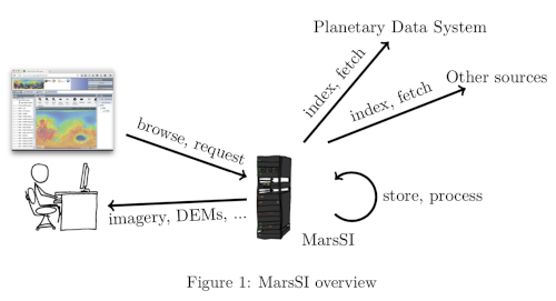
As of 2020, it indexes the optical (visible, multi and hyper-spectral) data from the recent orbiter missions, and allow to request the creation of Digital Elevation Models on demand. The focus, as highlighted by figure 1 is to allow the user to browse and request ”ready-to-use” products in regards of calibration, refinements and georeferencing. The user will be able to visualize and interpret the data in GIS or remote sensing software.
2 Architecture
MarsSI’s hardware is hosted at the Université Lyon 1 and is composed of a frontend server, a storage bay and a 80 core cluster. The software stack heavily relies on the OGC-defined standards for interoperability between components.
2.1 Catalog
MarsSI retrieve the footprints provided by the NASA Planetary Data System (PDS) in a database. These footprint information, alongside rasters that will be used as layers of our map display, is made available through a Mapserver instance. One issue we faced is the lack of Coordinates Referencing Systems definitions readily available in the WMS/WFS protocols, who rely on EPSG definitions codes. Adding and using non-standard EPSG definitions was a workaround to this issue.
Once the catalog, we proceed over the CTX and HiRISE data collections to find for each dataset overlapping images by at least 60% and a maximum differ- ence of acquisition angle of 10° to generate a list of potential Digital Elevation Models (DEMs).
2.2 Pipelines
Alongside the catalog, MarsSI uses several processing pipelines. Those pipelines defines steps and procedures to fetch, calibrate and refine products. A notable pipeline is the use of the Ames Stereo Pipeline [1] software to generate on- demand DEMs.
The pipeline execution is managed using the OAR (oar.imag.fr) batch scheduler.
One design choice of MarsSI was to present the products, including those created by the service, as global to all users (in contrast to service creating user-specific products). This was done to have only one reference to products like generated DEMs and reduce storage use. As a result, we only designed fully automated pipelines.
2.3 Frontend
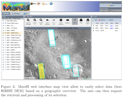
MarsSI client interface is a web component based on Geomajas (www.geomajas. org), a free and open source GIS toolkit. Geomajas interface directly with the mapserver instance and provide widget for the main interface, shown on figure 3.
3 Usage and data volumes
MarsSI is open to the scientific communities around the world. As of june 2020, we count 294 registered users across more than 128 institutes. Storage-wise, we benefited to progressively download data as requested, reaching 34To in 2020.
4 Perspectives
We are currently working on integrating other data types in MarsSI, such as the MARSIS and SHARRAD radar datasets.
Another aspect we are working on is a more efficient and intuitive web in- terface not based on Geomajas. The rewrite would also take into account other maps such as polar projections and other planetary bodies.
As DEMs are our most requested products, we are investigating how to pro- vide qualitative assessment for those datasets. We are also looking for methods to generate large scale DEMs using mosaicking.
5 Conclusion
Built upon frameworks using standardized protocols, MarsSI offers the scientific communities a way to search and request data, most notably DEMs that can be derived from CTX and HiRISE data collection. We are now looking to modernize and extend the service with a newer interface that can present other planets and moons data.
Acknowledgments
MarsSI is a national Research Infrastructure, recognised as such by the French Ministry of Higher Education and Research. It was supported by the Pro- gramme National de Planétologie (PNP) of CNRS/INSU, co-funded by CNES. It was initialy supported by the European Research Council under the European Union’s Seventh Framework Program (FP7/2007-2013)/ERC Grant agreement No.280168.
References
[1] Zachary M Moratto et al. “Ames Stereo Pipeline, NASA’s open source automated stereogrammetry software”. In: Lunar and Planetary Science Conference. Vol. 41. 2010, p. 2364.
[2] François Poulet et al. “PSUP: A Planetary SUrface Portal”. In: Planetary and Space Science 150 (2018), pp. 2–8.
[3] C. Quantin-Nataf et al. “MarsSI: Martian surface data processing informa- tion system”. In: Planetary and Space Science 150 (2018), pp. 157 –170. issn: 0032-0633. doi: https://doi.org/10.1016/j.pss.2017.09. 014. url: http://www.sciencedirect.com/science/article/pii/ S0032063316304718.
How to cite: Volat, M., Quantin-Nataf, C., Thollot, P., and Mandon, L.: MarsSI: Martian surface data processing service, Europlanet Science Congress 2020, online, 21 Sep–9 Oct 2020, EPSC2020-564, https://doi.org/10.5194/epsc2020-564, 2020.