
Landing site characterization for Tsiolkovskiy crater
 1,2,1,2
- 1Center of Studies and Activities for Space «G. Colombo», Padova, Italy (tognon.glo@gmail.com)
- 2Department of Geosciences, University of Padova, Padova, Italy
On the southern hemisphere of the lunar farside lies the interesting Tsiolkovskiy crater that presents on its floor one of the few exposures of mare volcanism on the far side and an unusually well-shaped central peak.
Its morphology and the remotely-sensed detection of minerals such as olivine and Purest Anorthosite (PAN), make Tsiolkovskiy crater an area to be considered for a possible landing site for a rover-based exploration. With this objective we are carrying on a geological characterization of this crater.
Tsiolkovskiy crater (20.4° S, 129.1° E) is a Late Imbrian impact crater with an elliptical shape and a minor axis diameter of about 180 km [1, 2].
Over the crater floor rises a ~3 km-high particularly bright and well-preserved central peak surrounded by an exclusively dark and smooth mare deposit formed by multiple eruptive events [2]. Moreover, on the central peak have been detected PAN [3, 4] and olivine [5].
The above-mentioned characteristics highlight the scientific interest represented by Tsiolkovskiy crater as a main driver to characterize its interior as landing site and evaluate the possibility to safely plan route traverses for rovers.
Aiming to focus the strategy of exploration for a future lunar landing mission we are producing geological maps of the area in order to select locations of high interest and traverse paths for in-situ investigations and analysis in order to help unravel key scientific questions concerning the origin and evolution of the Moon, the structure and composition of the lunar crust and interior and the presence of volatiles and of minor and trace elements.
The geomorphological mapping of the impact crater has been carried out on the Lunar Reconnaissance Orbiter Wide Angle Camera [6] global mosaic with a resolution up to 100 m/pixel along with elevation data derived from the Lunar Orbiter Laser Altimeter and Kaguya Terrain Camera DEM merge [7] with an horizontal and vertical resolution respectively of about 59 m/pixel and 3-4 m.
The surface morphology mapping has then been coupled with the spectral mapping performed on the ~200 m/pixel false color composite (Red 750/415 nm; Green 750/1000 nm; Blue 415/750 nm) generated using the Clementine UVVIS [8] reflectance image.
Moreover, an high-resolution mapping is being produced on Lunar Reconnaissance Orbiter Narrow Angle Camera (NAC) [7] images along with NAC-derived DEMs both with a resolution of about 0.5 m/pixel.
From the geomorphological mapping (Fig. 1) have been distinguished the following crater floor (CF) and crater walls (CW) units:
- CF smooth material: very smooth and planar material with a sharp boundary with respect to adjacent materials,
- CF hummocky material: rough material reworked during the impact and CW debris,
- CF central peak: sharp and well-recognizable central peak morphology,
- CW smooth ponds: smooth material areas texturally discording with respect to the surrounding areas,
- CW steep scarps: exposed steep scarps with slopes >40°,
- CW rim: terraces and scarps made up by collapsed material.
The spectral mapping (Fig. 2), instead, has been performed on the basis of the different color of the units, associated to a different origin and composition of the materials. The mapping allowed the distinction of the following units:
- Fresher basalts: predominant yellow color, corresponding to most of the CF smooth material,
- Basaltic plain: predominant orange color, corresponding to the remaining CF smooth material unit,
- Noritic-anorthosite/troctolite: light blue color, mostly correlated to the CF central peak and CW steep scarps units,
- Anorthosite: blue color, mostly correlated to the CF central peak and CW steep scarps units,
- Mature highland soil: red color, corresponding to the CW rim, CW smooth ponds and CF hummocky material units.
Finally, in the area surrounding the central peak of Tsiolkovskiy crater is being produced an high-resolution geological mapping with the aim to better define the geological setting for a rover-based exploration. So far, the mapping allowed to highlight some interesting features such as mare rilles and wrinkle ridges in proximity to the peak.
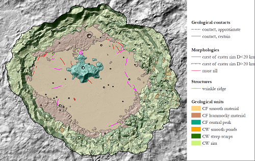
Fig. 1: Geomorphological mapping superposed on the hillshade generated from the Lunar Orbiter Laser Altimeter and Kaguya Terrain Camera DEM merge.
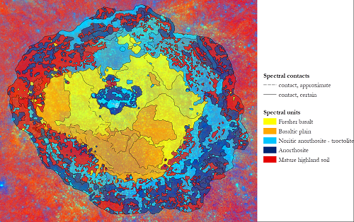
Fig. 2: Spectral mapping superposed on the Clementine UVVIS Color Ratio.
Here we presented the geomorphological and spectral mapping of Tsiolkovskiy crater performed so far. In the next future the high-resolution mapping will be completed and coupled with a spectral investigation by means of Chandrayaan-1’s Moon Mineralogy Mapper [9] data. Moreover, a radar investigation for the presence of deep structures, such as voids and lava pile emplacements, will be carried on by means of Kaguya Lunar Radar Sounder [10] data. To conclude, in order to perform a complete characterization of Tsiolkovskiy crater as a possible future landing site, we will perform a steepness and hazard analysis for the definition of the landing ellipses and route traverses for a rover exploration.
Acknowledgements
This research was supported by the European Union’s Horizon 2020 under grant agreement No 776276-PLANMAP.
References
[1] Whitford-Stark, J.L. & Hawke, B.R., XIII LPSC, pp. 861-862, 1982
[2] Pieters, C.M. & Tompkins, S., JGR, Vol. 104, pp. 21935-21949, 1999
[3] Ohtake, M. et al., Nature, Vol. 461, pp. 236-241, 2009
[4] Lemelin, M. et al., JGR: Planets, Vol. 120, pp. 869-8878, 2015
[5] Corley, L.M. et al., Icarus, Vol. 300, pp. 287-304, 2018
[6] Robinson, M.S. et al., Space Sci. Rev., Vol. 150, pp. 81–124, 2010
[7] Barker, M.K. et al., Icarus, Vol. 273, pp. 346-355, 2016
[8] Lucey, P.G. et al.,JGR, Vol. 105, pp. 20377-20386, 2000
[9] Pieters, C. M. et al., Current Science, Vol. 96, pp. 500-505, 2009
[10] Ono, T. et al., Space Sci. Rev., Vol. 154, pp. 145-192, 2010
How to cite: Tognon, G., Pozzobon, R., and Massironi, M.: Landing site characterization for Tsiolkovskiy crater, Europlanet Science Congress 2020, online, 21 September–9 Oct 2020, EPSC2020-581, https://doi.org/10.5194/epsc2020-581, 2020