The Lunar South Pole-Aitken Basin Region: A New Geological Map
- 1WWU Münster, Institut für Planetologie, Germany (c.poehler@uni-muenster.de)
- 2Vernadsky Institut, RAS, Russia
- 3School of Physical Sciences, The Open University, UK
- 4Department of Earth, Environmental and Planetary Sciences, Brown University, USA
Introduction: The lunar South Pole-Aitken basin (SPA) is of special interest for human and robotic missions for the near future [e.g. 1–4]. This makes detailed studies of the geological background and setting of the region a high priority. Located on the lunar farside, centered at ~53° S, 191° E, SPA basin is the largest and likely the oldest lunar basin [5-7]. The region is widely influenced by rays of the ~3.85 Ga old Orientale basin [8].
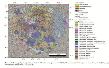
In this study, we constructed a geologic map of the full extent of the SPA basin, covering the South Pole, and extending eastward to include part of the Orientale basin (Fig. 1). Altogether, this provides a comprehensive overview of the geology of the region.
Methods: This map, which is an extension of an Apollo basin map [9], was done as part of the PLANetary MAPping (PLANMAP - H2020 n°776276) project (https://planmap.eu/). For large scale mapping, we used the Lunar Reconnaissance Orbiter (LRO) Wide-Angle Camera (WAC) basemap (100 m/pixel). For more detailed, smaller areas, and for identifying specific features, we used LRO Narrow-Angle Camera (NAC; 0.5 m/pixel) [10] and Kaguya (10 m/pixel) data with different incidence angles. We also used a hybrid spectral mapping technique using Clementine [11], M3 [12] and Kaguya MI [13] data. The topographic features were mostly mapped using Lunar Orbiter Laser Altimeter (LOLA) digital elevation models (DEMs) and a LOLA/Kaguya merged DEM with a resolution of 59 m/pixel [14]. To reduce shadows, particularly in the southernmost latitudes, we produced hillshade maps with various illumination conditions. We used PLANMAP mapping standards [15], which are based on USGS standards [16].
We identified units using morphological appearance and albedo contrasts. The mapping scale is 1:500,000. For the purpose of determining the stratigraphic relationships, we first established the relative ages of units using morphological evidence. For an absolute stratigraphy, we then performed crater size-frequency distribution (CSFD) measurements for fitting of absolute model ages (AMAs) using the production and chronology functions of [17]. CSFD measurements were made using CraterTools [18] in ArcGIS, and we fit the AMAs with Craterstats [19]. Detailed descriptions of the CSFD measurement technique are given by [17, 20]. The Apollo basin map is currently available on the PLANMAP website (https://data.planmap.eu/pub/moon/PM-MOO-MS-SPAApollo/) and the map of SPA will be available shortly.
Geology: In our study area, we defined three classes of geologic features: Basin materials, crater materials, and plains-forming materials. Basin materials are related to the formation of the large basins in the area with the oldest and most dominant being the SPA. We also specifically identified materials related to Apollo, Schrödinger, and Orientale Basins. Crater materials are divided into different classes according to the state of degradation and shape of the craters. For achieving a framework for the absolute chronology, we determined AMAs for several key craters. Plains-forming materials are characterized by their relatively flat, smooth surfaces and can be further divided into dark and light plains based on their albedo. Furthermore, we observed dark mantle material, which might be originate from pyroclastic volcanic events. These mantle materials occur most prominently in Schrödinger and Oppenheimer craters.
The SPA basin rim is obscured by various later impacts and is degraded due to its old age. The most distinctive appearance of the SPA basin rim is in the NW quadrant, close to the Apollo basin. Here, we identified two topographic rings of SPA basin rim massifs. Around the South Pole, image quality is lower and features become obscured by the low sun angle. We were able to find traces of the outer massif, but most of the inner massif is hidden below younger craters. The whole region is large influenced by the Orientale basin-forming impact, resulting in large quantities of ejecta-covered terrain and secondary cratering across the entire SPA basin.
Acknowledgments: This paper is part of a project that has received funding from the European Unions Horizon 2020 research and innovation programme under grant agreement Nº776276 (PLANMAP).
References: [1] Flahaut et al. (2019) PSS., in press. [2] Steenstraet al. (2016) Adv. Space Res. 58, 1050–1065. [3] Allender et al. (2018) Adv. Space Res. 63, 692–727. [4] Hiesinger et al. (2019) LPSC 50, 1327. [5] Garrick-Bethell and Zuber (2009) Icarus, 204, 399–408. [6] Hiesinger et al. (2012), LPSC 43, 1659. [7] Fortezzo et al. (2020), LPSC 51, 2760. [8] Stuart-Alexander (1978) USGS Map I-1047. [9] Ivanov et al. (2018) JGR Planets, 123, 2585–2612. [10] Robinson et al. (2010) Space Sci. Rev., 150, 81–124. [11] Pieters et al. (1994). Science, 266, 1844–1848. [12] Isaacsom et al. (2013). JGR, 118, 369–381. [13] Ohtake et al (2013) Icarus, 226, 364–374. [14] Barker et al. (2016) Icarus, 273,346-355. [15] wiki.planmap.eu/display/public/D2.1-public. [16] FGDC (2006). FGDC-STD-013-2016. [17] Neukum et al. (2001) Space Sci. Rev. 96, 55–86. [18] Kneissl et al. (2011) PSS, 59, 1243–1254. [19] Michael and Neukum (2010) EPSL, 294, 223–229. [20] Hiesinger et al. (2000) JGR, 105, 29239–29276.

How to cite: Poehler, C. M., Ivanov, M. A., van der Bogert, C. H., Hiesinger, H., Iqbal, W., Pasckert, J. H., Wright, J., and Head, J. W.: The Lunar South Pole-Aitken Basin Region: A New Geological Map , Europlanet Science Congress 2020, online, 21 Sep–9 Oct 2020, EPSC2020-600, https://doi.org/10.5194/epsc2020-600, 2020.

