
3D Imaging of Aristarchus Crater for Human Exploration on the Moon
 ,
,- University College London, Mullard Space Science Laboratory, Department of Space and Climate Physics, Dorking, United Kingdom of Great Britain and Northern Ireland (alfiah.putri.15@ucl.ac.uk)
Abstract
In order to provide a dataset for a Virtual Reality environment for Astronaut training, 3D images of 1m/pixel of Aristarchus Crater has been produced using the CASP-GO software based on the NASA’s Ames Stereo Pipeline. In addition to the 3D images, to provide the best viewing quality, 50cm/pixel images with the least shadow are chosen to be terrain corrected with the topographical information. This research will show the selection of the images used in this dataset, their processing, and the current status of the 3D imaging datasets.
1. Introduction
The NASA ARTEMIS Programme is a human exploration programme carried out by NASA, US commercial spaceflight companies, ESA, JAXA, and CSA. The programme is the next step in establishing a sustainable human presence on the Moon amongst other goals. Aristarchus is a young crater with transient features which was previously selected as a site for the Apollo 18 mission and is one of the landing site candidates for the ARTEMIS mission. To provide a VR dataset for astronaut training for the mission, the best 3D image dataset is needed, which we currently lack. This dataset can be achieved using LROC-NAC, the current highest resolution and coverage on the Moon that has been operating continuously since 2009.
A fully automated multi-resolution Digital Terrain Model processing chain for Mars stereo imagery (ESA-HRSC, NASA-MRO/CTX and HiRISE) based on the Ames Stereo Pipeline [1] has been developed at UCL within The EU-FP7 iMars project (http://www.i-mars.eu) called CASP-GO[2]. CASP-GO utilises tie- point-based multi-resolution image co-registration [3], and the Gotcha [4] sub-pixel refinement method. Since the end of the project in March 2017, thousands of CTX, and tens of HiRISE and HRSC 3D products have been processed with CASP-GO and have been published through the ESAC Guest Storage Facility (GSF) [5].

Figure 1: Current Version of the Aristarchus Image Mosaics
2. Methods
Stereo pairs have been selected from the official LROC-NAC stereo pair list. However, as the stereo pairs on the list only covers roughly half of the crater and ends in 2018, a MatLab code was written to look for a new set of stereo pairs to fill the gaps using the LROC-NAC coverage shapefiles (https://ode.rsl.wustl.edu/moon/indextools.aspx?displaypage=footprint) information until 2 February 2020.
Other than the ASP core pre-processing, initial matching, subpixel matching, camera triangulation, and DTM generation, five additional workflows are used to improve the DTM quality in CASP-GO. MGM is employed from the latest ASP pipeline to improve DTM quality [6]. A wrapper is written to allow processing of LROC-NAC stereo pairs in CASP-GO.
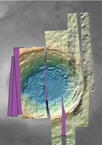
Figure 2: Current Coverage of Aristarchus Individual DTMs with remaining stereo pairs to process (purple)
3. Results
A base map was initially generated using the 20m/pixel Chang’E2 DTM [6] co-registered to the LOLA-SELENE 69m/pixel DTM product [7]. The 1m/ pixel DTMs are created using this DTM as a base for co-alignment using iterative closest point adjustment. Masks are created to crop out bad data, especially on the overlapping areas between multiple individual DTMs. Residuals are reduced by using the ISIS pc_align. The orthorectified 0.5-1m images are used as a reference alongside the Chang’E 2 orthorectified images and the LROC-WAC image to look for overlapping images with similar solar azimuth, phase, and solar elevation angles to produce 50cm/pixel images. The current mosaic is shown in Figure 1.
The resultant multi-resolution and bundle-adjusted co-registered 1m 3D models will be provided with a 0.5m mosaiced corrected image for employment with NASA Moontrek [7]. VR will be employed by NASA for astronaut training using these data for the ARTEMIS programme. These products will be made available through the ESA Guest Storage Facility once a peer review paper is accepted, the ESA-GSF is described elsewhere [8]. An example of a 3D view of the current version of the result is shown in Figure 3.

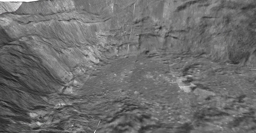
Figure 3: 3D View of images overlaid on Digital Terrain Models in QGIS 3D Map View
4. Summary and Future Work
In this research, a 1m/pixel Aristarchus DTM mosaic has been created using individual DTMs made using the UCL CASP-GO pipeline. A mosaic of images is being produced with the same viewing condition. A full assessment will be performed to provide the best quality DTM and ORI mosaics following the completion of the DTMs and the ORIs to help visualize the human mission to the moon. These 3D map products will be publicly released in the near future.
Acknowledgements
This work is funded by NASA Contract No. 1639009. Part of the research leading to these results has received partial funding from the European Union’s Seventh Framework Programme (FP7/2007-2013) under iMars grant agreement n˚ 607379. We thank Emily Law (NASA PDS) for helpful discussions and inputs.
References: [1] Beyer, R., et al. (2018), Earth and Space Science, vol 5(9), pp.537-548. [2] Tao, Y., J-P. Muller, Putri et al. (2018) PSS, Vol. 154, pp.30-58, [3] Tao, Y., Muller, et al. (2016), Icarus, vol 280, pp.139-157. [4] Shin, D. and J.-P. Muller (2012), Pattern Recognition, vol 45(10), pp.3795 - 3809. [5] Muller, J.-P. et al. (2019), Vol. 13, EPSC-DPS2019-1355-1. [6] Di, K et al. (2014). Planetary Geodesy and Remote Sensing, pp. 77–96. [7] Day, Schmidt, Law (2019) Vol. 13, EPSC-DPS2019-1154-1 [8] Barker, M.K. et al. (2016) Icarus, 273, 346–355.
How to cite: Putri, A. R. D., Chernetskiy, M., Tao, Y., and Muller, J.-P.: 3D Imaging of Aristarchus Crater for Human Exploration on the Moon, Europlanet Science Congress 2020, online, 21 September–9 Oct 2020, EPSC2020-617, https://doi.org/10.5194/epsc2020-617, 2020