
Long-term measurements of the erosion and accretion of dust deposits on comet 67P/Churyumov-Gerasimenko with the OSIRIS instrument
 1,1,5,3,5
- 1INAF-Astronomical Observatory of Padova, 35131 Padova, Italy (pamela.cambianica@oapd.inaf.it );
- 2INAf Astronomical Observatory of Trieste, via Tiepolo 11, 38121 Trieste, Italy
- 3Center of Studies and Activities for Space, CISAS, G. Colombo, University of Padova, via Venezia 15, 35131 Padova, Italy;
- 4Department of Physics and Astronomy "G. Galilei", University Padova, Via Marzolo 8, 35131 Padova, Italy;
- 5Department of Geosciences, University of Padova, Via Giovanni Gradenigo 6, 35131 Padova, Italy
The European Space Agency’s Rosetta mission was designed to orbit and land on the Jupiter-family comet 67P/Churyumov-Gerasimenko (hereafter 67P) for the first time. To investigate the nucleus, the Optical, Spectroscopic, and Infrared Remote Imaging System [1] was designed. The OSIRIS instrument consisted of two cameras operating from near ultraviolet to near infrared wavelengths. The Wide-Angle Camera (WAC) imaged the dust and the gas surrounding the nucleus with a spatial scale of 10.1 m/pixel at 100 km from the surface. The Narrow-Angle Camera (NAC) investigated the comet nucleus and its surface topography with a spatial scale of 1.86 m/pixel at the same distance. The surface of comet 67P immediately appeared geologically complex, with a large variety of terrains and geological features [2]. In addition, the OSIRIS observations revealed a dichotomy in appearance between the two hemispheres. In particular, the northern regions are almost fully covered by dust [2, 3]. On the contrary, in the equatorial regions, consolidated and coarse terrains seem to have replaced the dust on the surface [4]. This dichotomy is linked to the insolation and subsequent erosion of the surface [5]. The dust cover in the northern regions is the result of transport mechanisms of particles from the southern hemisphere during the southern summer [5, 6]. The strong insolation and the water ice content in the south could erode the surface up to 20 m [5] at the perihelion.
By applying the method developed by Cambianica et al. (2020) [6], we monitored the erosion and accretion of dust deposits of the Imhotep, Hatmehit, and Ma’at regions (Fig. 1) with a vertical accuracy of 0.4 m. The tool is based on the measurement of the shadow length projected by a boulder on the surrounding pebbles deposit. In Fig. 2 an example of the height measurement is shown. After assuming that the position of the boulder did not change during the observational period [7], any height variations provide an indication of how the thickness of the surrounding dust layer is varying in time through erosion and accretion phenomena. We measured the height of three populations of boulders, and the analysis covers the period from August 2014, inbound the perihelion, to September 2016, outbound. Our results show that equatorial regions remain almost inactive before perihelion, contrarily to the Ma’at region which shows erosion during the inbound orbit, and a subsequent dust deposit during the perihelion cometary activity. These results are in line with those found for the Hapi region [6], for which an erosion of the dust deposit of about 1.7 m during the inbound orbit and a fallout of 96% during perihelion cometary activity were measured [6]. Comparing our results with those obtained for the Hapi region, we confirm that the amount of the erosion in the southern hemisphere may be linked with the transport mechanism of the eroded material, and then to its fallout on the nucleus, justifying the presence of coarse terrain only in the southern hemisphere.
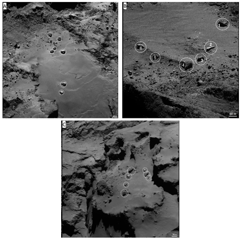
Fig. 1. OSIRIS NAC images showing the analyzed boulder populations located in the Imhotep (A), Hatmehit (B), and Ma’at (C) regions of 67P respectively. The first image of this set (A) was taken on 23 November 2014, at a distance of 30.1 km and a scale of 0.57 m/px. Image B was taken on 23 July 2016 at a distance of 10.22 km and has a scale of 0.19 m/px, while the last one (C) was taken on 13 September 2014 at a distance of 30.1 km and a scale of 0.56 m/px. White circles indicate the measured boulders.
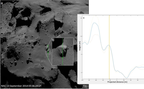
Fig. 2. (a) NAC view of the Ma’at region. This image was acquired in 2014. (b) Close-up of a boulder and of its shadow. The green line represents the projection of the Sun illumination direction. (c) Boulder section. The y-axis is oriented as the normal to the average plane around the peak of the shadow. The x-axis is obtained by projecting the green line in panel b on this average plane; the x-axis origin coincides with the peak of the shadow.
Acknowledgements
OSIRIS was built by a consortium of the Max-Planck-Institut für Sonnensystemforschung, in Göttingen, Germany, CISAS-University of Padova, Italy, the Laboratoire d’Astrophysique de Marseille, France, the Instituto de Astrofísica de Andalucia, CSIC, Granada, Spain, the Research and Scientific Support Department of the European Space Agency, Noordwijk, The Netherlands, the Instituto Nacional de Tecnica Aeroespacial, Madrid, Spain, the Universidad Politechnica de Madrid, Spain, the Department of Physics and Astronomy of Uppsala University, Sweden, and the Institut für Datentechnik und Kommunikationsnetze der Technischen Universität Braunschweig, Germany. The support of the national funding agencies of Germany (DLR), France (CNES), Italy (ASI), Spain (MEC), Sweden (SNSB), and the ESA Technical Directorate is gratefully acknowledged. We thank the ESA teams at ESAC, ESOC and ESTEC for their work in support of the Rosetta mission.
References
[1] Keller, H. U., Barbieri, et al. (2007). Osiris, the scientific camera system onboard Rosetta. Space Science Reviews, 128(1-4):433–506.
[2] Thomas, N., Sierks, H., et al. (2015). The morphological diversity of comet 67P/Churyumov-Gerasimenko. Science, 347(6220):aaa0440
[3] El-Maarry, M. R., Thomas, et al. (2015). Regional surface morphology of comet 67P/Churyumov-Gerasimenko from Rosetta/Osiris images. Astronomy & Astrophysics, 583:A26.
[4] Keller, H. U., Mottola, S., et al. (2017). Seasonal mass transfer on the nucleus of comet 67P/Chuyumov–Gerasimenko. Monthly Notices of the Royal Astronomical Society, 469(Suppl_2):S357–S371.
[5] Keller, H. U., Mottola, et al. (2015). Insolation, erosion, and morphology of comet 67P/Churyumov-Gerasimenko. Astronomy & Astrophysics, 583:A34.
[6] Cambianica, P., Fulle, M., Cremonese, et al., (2020). Time evolution of dust deposits in the Hapi region of comet 67P/Churyumov-Gerasimenko.\ Astronomy and Astrophysics 636, A91.
[7] Cambianica, P., Naletto, G., Cremonese, G. et al. 2019. Quantitative analysis of isolated boulder fields on comet 67P/Churyumov-Gerasimenko.\ Astronomy and Astrophysics 630, A15.
How to cite: Cambianica, P., Cremonese, G., Fulle, M., Simioni, E., Naletto, G., Pajola, M., Lucchetti, A., Penasa, L., and Massironi, M.: Long-term measurements of the erosion and accretion of dust deposits on comet 67P/Churyumov-Gerasimenko with the OSIRIS instrument, Europlanet Science Congress 2020, online, 21 September–9 Oct 2020, EPSC2020-724, https://doi.org/10.5194/epsc2020-724, 2020