
 4,4,5,4,
- 1Sorbonne université, IMPMC, France (william.rapin@gmail.com)
- 2Univ. Lyon, LGLTPE, France
- 3University of California, Santa Cruz, USA
- 4LPG, CNRS-Univ. Nantes, France
- 5IRAP-OMP, CNRS-UPS, Toulouse, France
- 6Astrogeology Science Center, USGS, Flagstaff, USA
- 7Caltech, Pasadena, USA
- 8LANL, New Mexico, USA
Introduction: Gale crater preserves a 5 km thick sequence of stratified rocks, the lower-most section of which exhibits orbital spectra signatures of clay minerals transitioning up to sulfates over several hundred meters of stratigraphy [1,2]. Understanding the reason for this wet-to-dry change in the mineralogical signature is one of the primary objectives of the Curiosity rover exploration. The rover is currently positioned at the toe of the Layered Sulfate unit (LSu) exposed over a thousand meters in elevation and characterized from orbit by its general-layered texture and spectral signatures of monohydrated and polyhydrated Mg-sulfates [1–4].
Here we reconcile orbital data with new in situ analyses using MastCam and the Remote Micro-Imager (RMI) of the ChemCam instrument to provide an updated documentation of the LSu stratal components at large outcrop scales and at the highest available resolution. We then propose a provisional model for the depositional systems and their evolution in the sulfate unit, hypothesized to reflect overall diminishing availability of liquid water.
Dataset and Methods: The ChemCam RMI can perform long-distance image acquisitions, i.e. several kilometers away, with discernable features between 4-10 cm at 1 km, and 0.2-0.5 m at 5 km in the best focus conditions [5,6]. Beyond 5 kilometers the spatial resolution of HiRISE orbital images is better than that of the RMI, yet both still complement each other by offering orthogonal viewing angles. Usually a series of individual RMI is acquired, forming a mosaic of the target, which are first processed, including dark and flat field correction, then stitched, denoised and slightly sharpened to highlight small-scale contrasts [7].
Using the Visibility Tool of ArcGIS, the RMI mosaics were geolocated within a digital elevation model (DEM) as projected view sheds to enable accurate positioning of the outcrops observed on the RMI into the stratigraphic column (Figure 1).
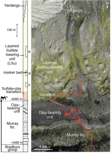
Figure 1: Stratigraphic context and close-up map of Mt Sharp with layered sulfate-bearing unit to be explored by the Curiosity rover. The column represents units elevation (left) along with intervals covered by RMI (Figure 2). Close-up map uses HiRISE MSL basemap overlaid with CRISM S-index in shaded yellow (right). Elevation contours on the sulfate-clay transition (dashed white) are shown with rover path (red).
Large-scale eolian crossbedding: Structures characteristic of large-scale, trough and planar crossbedding are observed in the lower section of the LSu, with large sets bounded by a variety of erosive surfaces (Figure 2c,f). Such cross-bedding forming 5 to 8 meters thick bedsets is most likely diagnostic of aeolian dunes due to its large scale [8]. Overall, no clear tabular crossbedding associated with sand sheet strata has been identified, and structures correspond instead to trough crossbedding as could be formed by superimposed dunes migrating in different directions.
The marker bed as a major deflationary surface: The marker bed is a regionally extensive, thin, smooth, dark-toned layer distinguishable from orbit for 10s of km at a similar elevation around Mt Sharp [2]. Curiosity now observes it in cross-section at higher resolution and reveals a variably prominent, few meter thick, resistant lip which crosscuts underlying strata (Figure 2d,g). The heterogeneous texture includes patches of planar bedded deposits similar to underlying strata and lens-shaped zones of disrupted or rubbly lithologies. Based on geometric and textural evidence, we hypothesize that the marker bed represents a super bounding surface, a type of erosional surface common to terrestrial eolian sequences and corresponding to a break in dunes development [9].
A Fluvial Depositional system in the upper LSu: Above the marker bed, the layering forms decameter thick beds ending with stratal bifurcations, interruptions, or wedgings. Three types of facies can be distinguished: (i) resistant, variably massive bodies; (ii) heterolithic facies with interbedded recessive and resistant elements; (iii) recessive, variably-toned facies. So far in outcrops observed in situ along the Curiosity rover traverse, resistant features of similar scale range from conglomeratic to fine-sandstone lithofacies, whereas recessive intervals are composed of mudstones [10]. We hypothesize that the LSu follows this connection, and propose in our model that the textures could represent a fluvial facies tract, with channel, bank, levee and floodplain deposits (Figure 2e,h).
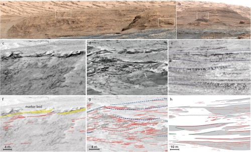
Figure 2: MastCam mosaic of buttes with RMI observations (a: mcam12635; b: mcam06060). RMI mosaic close-ups on sedimentary structures (c-e) and overlayed with tracings (f-h). Modeled structures include: eolian trough crossbedding (f) with bounding surfaces (dashed blue) and sets of cross-strata (red); unconformable boundary at the marker bed (g) with disrupted or rubbly lithologies representing possible lag deposits (shaded yellow) and surrounding strata (red); Fluvial depositional system (h) in the decameter thick layering (dashed lines) with channelized and wedged erosion resistant sandstone bodies (shaded gray) and stratification (red).
Discussion: These observations in the distance, both from orbit and the from the rover, indicate an evolution of depositional environments with fluctuations between wetter and dryer climate at the scale of hundreds of meters in the stratigraphy. Future ground investigation by the Curiosity rover will test and refine the model in these key stratigraphic intervals.
References: [1] Fraeman A. A. et al. (2016) J. Geophys. Res. Planets 121, 1713–1736. [2] Milliken R. E. et al. (2010) Geophys. Res. Lett. 37, L04201. [3] Powell K. E. et al. (2019) LPSC, p. 1455. [4] LeDeit L. et al. (2018) LPSC, p. 1437. [5] Langevin Y. et al. (2013) LPSC, p. 1227. [6] Herkenhoff K. E. et al. (2018) LPSC, p. 2155. [7] Le Mouélic S. et al. (2019) LPSC, p. 2132. [8] Bradley R. W. and Venditti J. G. (2017) Earth-Sci. Rev. 165, 356–376. [9] Kocurek G. (1988) Sediment. Geol. 56, 193–206. [10] Edgar L. A. et al. (2018) Sedimentology 65, 96–122.
How to cite: Rapin, W., Dromart, G., Rubin, D., Le Deit, L., Mangold, N., Fox, V., Gasnault, O., Herkenhoff, K., Le Mouélic, S., Dickson, J. L., Ehlmann, B. L., Maurice, S., Wiens, R. C., and Edgar, L. A.: Predicting changes in depositional environments up Mount Sharp stratigraphy, Europlanet Science Congress 2020, online, 21 Sep–9 Oct 2020, EPSC2020-757, https://doi.org/10.5194/epsc2020-757, 2020.