
3D geomodel of the deformed deposits in Crommelin Crater (Mars)
 ,
,- University of Padova, Department of Geosciences, Padova, Italy (riccardo.pozzobon@unipd.it)
Crommelin Crater is a ~90km impact crater, located at 349.8° E and 5.1° N in Arabia Terra (Mars). This particular region displays a pervasive water and fluid activity fingerprint, made of several sulphate-bearing minerals, recorded both in Arabia and the nearby meridian planum and light albedo fine-layered deposits. These, informally named ELD (equatorial layered deposits [1, 2]) can be found both within craters and in the surrounding plateaus, and can range from 10 m to more than 1 km of thickness [1]. Indeed, several km-thick bulges made by ELDs can be seen within several craters of Arabia, among which the Crommelin Crater [1].
Its bulge is slightly elliptical in shape (50*30 km) covering almost more than half the size of the entire crater, with the surroundings of the bulge encompassed by gently folded ELDs. In order to investigate the possible origin of the bulge and of the folding we firstly performed a geological and structural mapping on a mosaic of CTX orthoimages at 6m/pixel (Context Camera onboard MRO [3]) and DEMs (Digital Elevation Models).
For this purpose we created a merged DEM of the whole crater area based on multi-resolution DEMs by means of CTX DEMs at 18 m (covering 2/3 of the crater), HRSC DEMs with 100 m and the final data gaps covered by MOLA MEGDR (Mars Orbiter Laser Altimeter Experiment Gridded Data Records [4]) data with 463 m of grid spacing respectively. From the geologic map, scaled 1:160.000, we could see that the bulge units occupy a lower stratigraphic level than the surrounding ELDs. These appear heavily eroded and dismantled with sharp contact at the base of to the bulge. We extracted ELD dip and strike measurements and combined them with the mapping of the prominent ELD strata: this way we were able to carry out a structural interpretation and to mark the position of inferred fold axes. Cross sections were defined crosscutting the strata orthogonally to their strike and topographic profiles together with all relevant information, such as inferred fold axes, intersecting bedding traces and local bedding attitude, were automatically computed for the chosen section traces by MOVE software with the aid of the DEM; the geologic interpretation was afterwards carried out in each of the cross-sections. The structural analysis highlighted the presence of gently folded strata whose axial planes appear concentric with respect to the bulge. Km-size symmetric folds sets are visible on the western sector, whereas asymmetric folds with radial outwards vergence are visible on the northwestern sector, appearing more pronounced in the proximity of the bulge. In the southern sector, a sequence of elliptical basins with inward dipping strata and major axis concentric to the bulge suggest a dome-basin interference pattern of folding. In order to further investigate the folded geometries and the structural setting, we approached the problem in 3D in MOVE software. By interpolating the same stratigraphic horizons across 13 interpreted cross-sections of the folded strata of the ELD unit in the western ans southern crater sectors, we reconstructed the full 3D geometry of deformed strata and built 3D ribbons of the main geologic contacts. The overall geostructural observations and the 3D reconstruction point towards the idea of a bulge uplift after the deposition of the surrounding layered deposits, that have caused fold sets typical of a diapiric phenomenon.
Acknowledgments: This research was supported by European Union’s Horizon 2020 under grant agreement No 776276- PLANMAP.
References:
[1] Pondrelli, M., Rossi, A.P., Le Deit, L., Fueten, F., van Gasselt, S., Glamoclija, M., Cavalazzi, B., Hauber, E., Franchi, F., Pozzobon, R., 2015. Equatorial layered deposits in Arabia Terra, Mars: facies and process variability. Geol. Soc. Am. Bull. https://doi.org/10. 1130/b31225.1.
[2] Hynek, B.M., Arvidson, R.E., Phillips, R.J, 2002. Geologic setting and origin of Terra Meridiani hematite deposit on Mars. J. Geophy. Res. Planet. 107 (E10), 18 -11-18-14.
[3] Malin, M.C., Bell, J.F., III, Cantor, B.A., Caplinger, M.A., Calvin, W.M., Clancy, R.T., Edgett, K.S., Edwards, L., Haberle, R.M., and James, P.B., 2007, Context Cam- era investigation on board the Mars Reconnaissance Orbiter: Journal of Geophysical Research, v. 112, E05S04, doi: 10 .1029 /2006JE002808 .
[4] Smith, D.E., Zuber, M.T., Solomon, S.C., Phillips, R.J., Head, J.W., Garvin, J.B., Banerdt, W.B., Muhleman, D.O., Pettengill, G.H., Neumann, G.A., Lemoine, F.G., Abshire, J.B., Aharonson, O., Brown, C.D., Hauck, S.A., Ivanov, A.B., McGovern, P.J., Zwally, H.J., and Duxbury, T.C., 1999, The global topography of Mars and implications for surface evolution: Science, v. 284, p. 1495–1503, doi: 10 .1126 /science .284 .5419 .1495 .
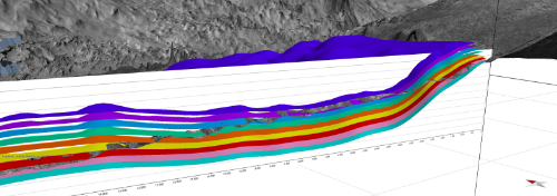
Figure 1: example of the reconstructed 3D layers in western Crommelin, in section view
How to cite: Pozzobon, R., Pesce, D., and Massironi, M.: 3D geomodel of the deformed deposits in Crommelin Crater (Mars), Europlanet Science Congress 2020, online, 21 September–9 Oct 2020, EPSC2020-770, https://doi.org/10.5194/epsc2020-770, 2020