Three-dimensional reconstruction and quantification of fluvial-deltaic sedimentary deposits in Gale crater, Mars, from rover-derived Digital Outcrop Models.
- 1Imperial College London, Earth Science and Engineering, London, United Kingdom of Great Britain and Northern Ireland (robert.barnes@imperial.ac.uk)
- 2Joanneum Research, Steyrergasse 17, 8010 Graz, Österreich.
- 3VRVis Center for Virtual Reality and Visualization Research GmbH, Donau-City-Strasse, 11, 1220, Vienna, Austria.
Modern and ancient fluvial-deltaic systems on Earth contain highly diverse ecosystems in all terrestrial climates. Fluvial and lacustrine deposits have been discovered on Mars by the NASA Mars Science Laboratory rover Curiosity, and may be present in Oxia Planum, where the ESA/ROSCOSMOS ExoMars rover Rosalind Franklin is set to land in 2023. The primary aim of the ExoMars mission is to search for signs of past and present life on Mars. Whilst fluvio-deltaic-lacustrine sandstones and mudstones are high priority targets for sampling and drilling, it is important to obtain information on the palaeoenvironmental context of these deposits during mission exploration.
The geometries of sedimentary structures and distribution of sedimentary facies within fluvial deposits provide information which can be used to reconstruct the geometries and flow parameters of these ancient systems. This provides us with quantitative means with which to make inferences on the ancient climate of Mars, and aids decision making with regards to rover science operations. Here we present a detailed quantitative 3D analysis of fluvial sedimentary architecture on Mars using rover image data. We used the 3D visualization software tool PRo3D1 to render the Shaler outcrop, observed at Yellowknife Bay by the NASA Mars Science Laboratory Rover, Curiosity2, as a scaled 3D textured model using the PRoViP 3D vision processing software3, and to map out key sedimentological features in order to characterize their geometry and dimensions, following existing facies descriptions4 .
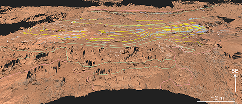
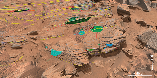
Mastcam data taken from different rover locations was processed into 3D surfaces and spatially matched to Navcam stereo-panoramas to create a digital outcrop model (DOM). The Shaler DOM was constructed using 17 Mastcam stereo-panoramas taken on Sols 120-121 and 309-324. A 30 m x 13 m area of the NE-SW trending outcrop was analysed. Sedimentary facies, key bounding surfaces and sedimentary structures were mapped out on the DOM (Fig. 1) and the dip and strike of lithological boundaries, key bounding surfaces, and cross-laminations were measured directly from the DOM. Apparent widths and thicknesses of the layers and cross-lamination sets were measured. Regularly spaced, sedimentary logs were collected and matched to illustrate the detailed internal structures of the outcrops analysed. Four types of sedimentary structures were identified; low-angle cross strata dipping to the SE (Fig. 2), ~ 50 cm thick; convex up, sub-parallel undulating laminations forming structures with 20-40 cm amplitude and 2 m wavelength; single sets of trough cross-laminations and compound, stacked cosets of trough cross-laminations, with thicknesses on average 9 cm, and yielding a common palaeoflow direction to the NE and SW. These data allow us to reconstruct the internal architecture of a fluvial bar-form which forms the Shaler outcrop, and quantify the key geometries and their spatial relationships in three-dimensions. These data are highly useful in providing context and relative timings for environmental reconstruction.

Figure 1. Line interpretation of Shaler in PRo3D, showing the lithological boundaries (pink lines), facies assocation boundaries (green lines), accretion surfaces (yellow lines), layer contacts (white lines), cross-lamina sets (blue lines) and undulatory convex up bedforms (green lines).

Figure 2. Detailed view of stacked sets of cross-laminations in the southwestern part of the Shaler outcrop.
1. Barnes et al., 2018, Geological Analysis of Martian Rover‐Derived Digital Outcrop Models Using the 3‐D Visualization Tool, Planetary Robotics 3‐D Viewer—PRo3D. Earth and Space Science.
2. Grotzinger et al., 2014, A Habitable Fluvio-Lacustrine Environment at Yellowknife Bay, Gale Crater, Mars. Science
3. Paar et al., 2015, PRoViDE: Planetary Robotics Vision Data Processing and Fusion. European Planetary Science Congress 2015.
4. Edgar et al., 2017, Shaler: in situ analysis of a fluvial sedimentary deposit on Mars. Sedimentology.
How to cite: Barnes, R., Gupta, S., Paar, G., Bauer, A., Ortner, T., and Traxler, C.: Three-dimensional reconstruction and quantification of fluvial-deltaic sedimentary deposits in Gale crater, Mars, from rover-derived Digital Outcrop Models., Europlanet Science Congress 2020, online, 21 September–9 Oct 2020, EPSC2020-821, https://doi.org/10.5194/epsc2020-821, 2020

