Using band ratioed CaSSIS imagery and analysis of fracture morphology to characterise Oxia Planum’s clay-bearing unit
- 1Space Research Centre, University of Leicester, Leicester, United Kingdom of Great Britain and Northern Ireland (acdpb1@le.ac.uk)
- 2LGLTPE, Université de Lyon 1, Lyon, France (lucia.mandon@univ-lyon1.fr)
- 3Centre for Planetary Science and Exploration, University of Western Ontario, Canada (ltornabe@uwo.ca)
- 4Department of Physics, Imperial College London, London, United Kingdom of Great Britain and Northern Ireland
- 5Physikalisches Institut, Universität Bern, Bern, Switzerland (nicolas.thomas@space.unibe.ch)
- 6Istituto Nazionale di Astrofisica (INAF), Osservatorio Astronomico di Padova (OAPD), Padova, Italy (gabriele.cremonese@oapd.inaf.it)
Introduction:
In an effort to aid the characterisation of Oxia Planum, selected as the Rosalind Franklin rover’s landing site partly due to its extensive Noachian-era clay deposits [1, 2], a comparison of fractured terrains at Oxia and Gale Crater along with an analysis of Colour and Stereo Surface Imaging System (CaSSIS) [3] imagery are currently underway.
An analysis of fractured terrains is a useful tool for determining the history and material properties of Oxia, as the form a fracture network takes varies depending both on the mechanisms which generated it as well as the materials within which the fracturing occurred [4-6]. Comparisons between fractured terrains across Oxia, as well as with those at Gale crater due to the ground truth provided by the Curiosity rover, are being made. This is done in an effort to predict material properties and the fracture’s formation mechanisms, along with determining how fractures across Oxia relate to one another.
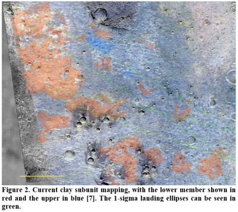
CaSSIS is a high-resolution (4.5 m/pixel) 4-band VNIR imager with the ability to take stereo images in a single pass of a target. From a study carried out using CaSSIS, along with co-analysis from CRISM and HiRISE colour imagery, two spectrally and morphologically distinct subunits of the Oxia clay unit [7] were identified. These were a lower member showing metre-scale fracturing and spectral signatures indicative of Fe/Mg-rich clay minerals, and an upper member showing decametre scale fracturing with Fe/Mg-rich clay mineral/olivine signatures. To expand upon the mapping carried out using HiRISE colour and CRISM data, which was limited by data coverage [7], CaSSIS and HiRISE RED i.e. greyscale imagery, was used to identify these sub-units. This was done to aid future planning of rover traverses to high priority surface targets.
Methods:
Fracture Analysis. Our fracture analysis involves tracing out a given fracture network in HiRISE imagery using ArcGIS, then using a tool developed at the Open University (as seen in [8]) to measure metrics of the fractures or the polygons formed by them, such as the angle between intersecting fractures, polygon area, etc. These were then mapped out for comparison using Kernel Density Estimation (KDE) diagrams, and compared statistically via two-sample Kolmogorov-Smirnov tests.
CaSSIS mapping. Radiometrically and geometrically corrected images are initially band ratioed and combined into an RGB image, allowing CaSSIS images to distinguish between ferrous and ferric minerals [9]. This is important given that the lower clay unit has a ferric component potentially due to the presence of hematite/ferric oxides [2], in contrast to the ferrous component of the upper member due to containing olivine [7], making the two members distinguishable with CaSSIS.
The band ratios (BR’s) used were NIR/PAN, PAN/BLU and PAN/NIR, with CaSSIS’s RED channel replacing its NIR depending on which was available from a given CaSSIS image [10]. These are sensitive to ferric and ferrous minerals for the former two and latter one respectively. Dark Subtraction [11] was then applied to minimize the effects of dust-derived atmospheric scatter. These images were used in conjunction with assessment of fracture length using HiRISE imagery to map out the two members. It has previously been identified [7, 12] that high dust opacity at the time of imaging likely skews the apparent ferric content of the image. This has been noted and is addressed via repeat imaging of such affected areas over Oxia Planum.
Results:
Fracture Analysis. The Gale sites which have comparable metric distributions to those at Oxia are the NE section of Yellowknife Bay’s Sheepbed member [13], which has similarities to several sites seen in the centre of the Oxia landing ellipses, and a site at Vera Rubin ridge similar to an area adjacent to Coogoon Vallis in the SE of Oxia Planum and another abutting the capping unit in the centre of the landing ellipses. Both of these are at the 2-sigma level of certainty for the majority of the metrics. See Figure 1 for examples of the KDE graphs used.
CaSSIS mapping. Figure 2 shows the current extent of the mapping within the 1-sigma landing ellipses at Oxia. There are fewer upper member exposures in the area mapped in fig.2, in line with what has been identified previously [7].

Discussion:
Fracture Analysis. While the results from this study show that there are similarities between some of the fractured terrains examined at Oxia Planum and Gale Crater, what the shared properties of these sites are that leads to these similarities is still being considered. Possibilities include possessing a similar grain size, or sharing the same formation mechanism such as hydraulic fracturing [1].
CaSSIS mapping. Mapping is ongoing for the 1-sigma landing ellipses, with the intention for it to cover the 3-sigma ellipses ultimately. That the map utilises distinctly lower resolution colour imagery of CaSSIS in conjunction with the 0.25 m/pixel HiRISE imagery for observation of fracturing raises the issue of misidentification of the two units where they are in close proximity. Pan-sharpening is being investigated as a solution to this; currently work is ongoing to remove artifacts within the generated products prior to their use in future mapping efforts.
References: [1] Quantin-Nataf C. et al. (submitted in Astrobiology), [2] Carter et al. (in prep), [3] Thomas et al. (2017) SSR 212, [4] Tang C-S. at. al. (2011) Geoderma, 166(1):111-118, [5] Plummer P. S. et. al. (1981) JSP, 51:1147-1156, [6] Goehring L. et. al. (2010) SM, 6:3562-3567, [7] Mandon L. et al. (submitted in Astrobiology), [8], Brooker L. M. et al. (2018) Icarus 302:386-406 [9] Tornabene L. L. et al. (2018) SSR, 214, [10] Tornabene L. L. et al. (2019) LPSC 50, Abstract #2678, [11] Chavez et al., (1988), RSE, 24.3: 459-479, [12] Parkes Bowen A. et al. (2020) BPSC #2, [13] Grotzinger J. P. et al. (2014) Science, 343:6169
How to cite: Parkes Bowen, A., Mandon, L., Bridges, J., Quantin-Nataf, C., Tornabene, L., Page, J., Briggs, J., Thomas, N., and Cremonese, G.: Using band ratioed CaSSIS imagery and analysis of fracture morphology to characterise Oxia Planum’s clay-bearing unit , Europlanet Science Congress 2020, online, 21 Sep–9 Oct 2020, EPSC2020-877, https://doi.org/10.5194/epsc2020-877, 2020.

