
The role of water on Sinus Sabaeus region, Mars
 1,2,1,1
- 1Centro de Astrobiología (CSIC-INTA)
- 2Universidad Rey Juan Carlos
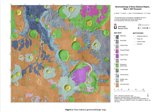
The study area (148.155 km2, Figure 1) is located in the southern equatorial region of Mars, approximately centered at 26.0° S and 6.5° E. Although subjected to extensive surface erosion, this heavily cratered region, selected as a representative section of the densely cratered highlands [1], still shows evident signs of past water erosion in the form of valley networks that regularly dissect the surface. As such, is an ideal area to study the role of water in modifying the surface of the Martian highlands.
The top elevation of the mapped region is located in the central and eastern areas, reaching a maximum elevation of 2,606 meters above the Martian datum (a.m.d.). The points of lower elevation in the area are locally inside impact craters (-678 m a.m.d.). We found two unusually large impact craters. One is at the northeast, about 180 km in diameter, and only its southern half is inside the area. The other is at the southeast, irregularly shaped, and 116 km in diameter. The topography in the mapped region is also defined by two large valley network systems which carve the surface flowing from south to north, and surround the positive relief at each flank.
We have produced a 1:500.000 scale geomorphological map with unprecedented detail, using ArcGIS 10.3 Desktop Software (ESRI) to draw and compiled a combination of a mosaic of hi-resolution CTX images, complemented by available Context Camera (CTX) images for cover gaps [2], a mosaic composed by MOLA and HRSC topography [3], and THEMIS-IR day imagery [4].
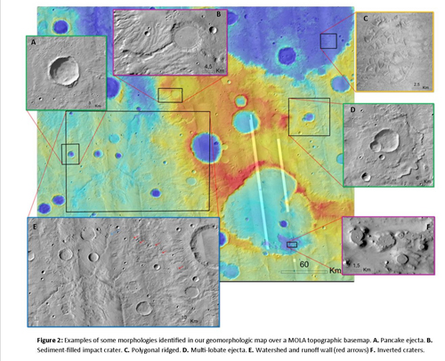
We mapped the main morphological units to contribute to the understanding of the hydrology of
this understudied region of Mars. We mainly focus on describing eleven different morphological units
and four geomorphic features (Figure 2), related to the past presence of water, as both ice and liquid,
to allow us to characterize the past environment and eventually to identify their presence and
persistence.
Among these units we would like to highlight the watershed unit, formed by incisions on the
surface that we interpret as evidence of aqueous activity, in which water came from channels that
flowed by the runoff wall unit. We differentiate a few types of impact craters, highlighting the inverted
crater unit and the sediment-filled impact crater unit, both filled up with sedimentary materials maybe
sourced by paleo-lakes. We differentiate two ejecta units related to liquid and ice water reservoirs;
and a polygonal ridged unit and a knobby terrain unit associated with permafrost environments.
Acknowledgments: This research is a contribution of the Project ”MarsFirstWater”, European
Research Council, Consolidator Grant no. 818602. Authors also thank the Agencia Estatal de
Investigación (AEI) project no. MDM-2017-0737 Unidad de Excelencia ”María de Maeztu”, and Rey
Juan Carlos University.
References: [1] Forsberg-Taylor, et al., (2004). Journal of Geophysical Research: Planets, 109
(E5). [2] Fergason R.L. et al. (2018) Astrogeology PDS Annex, USGS. [3] Dickson J.L. et al. (2018)
49th LPSC, Abstract#2083. [4] Christensen, P. R et al. (2004). Space Science Reviews, 110 (1), 85–
130.
How to cite: Robas, C., Molina, A., López, I., Prieto-Ballesteros, O., and Fairén, A.: The role of water on Sinus Sabaeus region, Mars, Europlanet Science Congress 2020, online, 21 Sep–9 Oct 2020, EPSC2020-967, https://doi.org/10.5194/epsc2020-967, 2020.