
Grid mapping survey for water- and volcanic-related features along Arabia Terra in the context of the ExoMars landing site
 1,3,4,1,1
- 1Centro de Astrobiología (CSIC-INTA)
- 2European Space Astronomy Centre (ESAC)
- 3Universidad Rey Juan Carlos
- 4Universidad de Alcalá
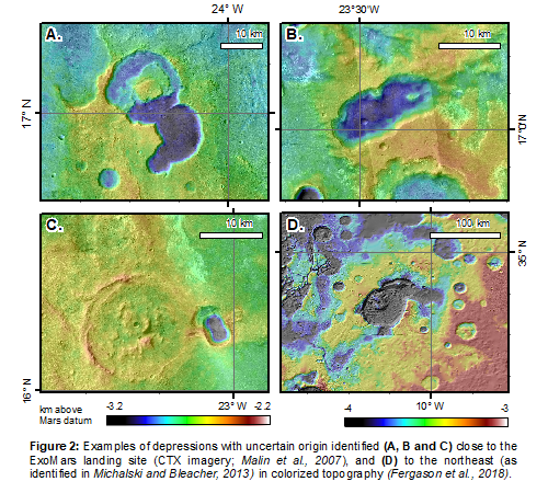
The ExoMars Rosalind Franklin rover is scheduled to land in Oxia Planum, at the outlet of Coogoon Valles, in 2023. The site is located in the western Arabia Terra region, the most gradual transition of the planetary topographic dichotomy, also considered to be one of the oldest terrains of Mars (Davis et al., 2016). Despite the high potential of the area as a promising location to search for ancient life, some aspects of its regional geologic context remain elusive. The extremely complex hydrologic history of Coogoon Valles system (Molina et al., 2017) is one example of the difficulty in addressing its geologic record. The Arabia Terra surface is extensively modified, and the paucity of valley networks (Figure 1A) and the presence of many inverted structures (Hynek et al., 2010; Davis et al., 2016; Davis et al., 2019) seem to indicate a widespread denudation. Besides, some of the phyllosilicate-bearing light-toned layered materials found in the area could have been formed by weathered airborne transported volcanic tuffs or ashes, that may cover older features. The absence of obvious volcanic edifices near the study area, that could be a source for these materials (Kerber et al., 2012), does not exclude the presence of yet undiscovered volcanic sources in the vicinity. Some crater-like structures, which lack typical features of impact origin, could have been formed by tectonics, groundwater, thermokarst, or volcanic collapses (or a combination of all; Figure 2). Their morphology favors a volcanic origin (Molina et al., 2019), perhaps similar to the plain-style calderas described to the NE of Arabia Terra (Figure 2; Michalski and Bleacher, 2013).
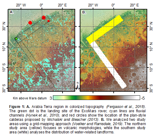
The distribution of relatively small water- and volcanic-related features in the region provides additional evidence for processes that are difficult to assess on a regional scale. We have performed a grid-based mapping (Ramsdale et al., 2017; Voelker and Ramsdale, 2019) in two perpendicular study areas that overlap in the landing site area (Figure 1). The northern study area was separated into 2,171 grids (each 20x20 km, yellow in Figure 1B). It follows the dichotomy scarp from the landing site until reaching the plain-style calderas to the northeast (Michalski and Bleacher, 2013). Here we looked for features related to volcanic and thermokarstic activity as depressions pits, flows, and ridges. The other study area (2,563 grids, white in Figure 1B) transverses the dichotomy from the landing site southbound to Sinus Sabaeus in the Noachian highlands, where records of fluvial activity are much more prevalent (Robas et al., 2019). In this case, we looked for modified craters and various water-related features. In addition to that, we mapped further landforms found in both study areas, as knob fields, light-toned deposits, and channels. To identify the different features we used the global mosaic composed of CTX images (Malin et al., 2007; Dickson et al., 2018), a topographic mosaic from MOLA and HRSC data (Smith et al. 2001; Jaumann, R. et al. 2007; Fergason et al., 2018), and the quantitative THEMIS-derived global thermal inertia mosaic (Christensen et al., 2004, 2013).
Acknowledgments: This research is a contribution of the Project ”MarsFirstWater”, European Research Council Consolidator Grant no. 818602. The authors also thank the Agencia Estatal de Investigación (AEI) project no. MDM-2017-0737 Unidad de Excelencia ”María de Maeztu”, and Rey Juan Carlos University.
References:
Christensen P. R. et al., Space Sci Rev. 110, 85–130 (2004).
Christensen P. R., R. L. Fergason, C. S. Edwards, J. Hill, in LPSC, 44, No. 1719, id. 2822 (2013).
Davis J. M., M. Balme, P. M. Grindrod, R. M. E. Williams, S. Gupta, Geology. 44, 847–850 (2016).
Davis J.M. et al, J Geophys Res Planets. 124(7), 1913–1934. (2019).
Dickson J. L. , L. A. Kerber, C. I. Fassett, B. L. Ehlmann, in LPSC, 49, No. 2083, id. 2480 (2018).
Fergason R. , T. Hare, J. Laura, Astrogeology PDS Annex, US Geological Survey (2018).
Hynek B. M., M. Beach, M. R. T. Hoke, J Geophys Res Planets. 115 (2010).
Jaumann R. et al., Planet Space Sci. 55, 928–952 (2007).
Malin M. C. et al., Journal of Geophysical Research: Planets, 112, E5 (2018).
Michalski J. R. , J. E. Bleacher, Nature. 502, 47–52 (2013).
Molina A. et al., Icarus. 293, 27–44 (2017).
Molina A., O. Prieto-Ballesteros, I. López, C. Robas, A. G. Fairén, in EANA Conf., 282577 (2019).
Ramsdale J. D. et al., Planet Space Sci. 140, 49–61 (2017).
Robas C., A. Molina, I. López, O. Prieto-Ballesteros, A. G. Fairén, in EANA Conf., 280888 (2019).
Voelker M., J. D. Ramsdale, in Planetary Cartography and GIS, H. Hargitai, Ed. (Springer International Publishing, Cham, 2019), pp. 293–302.
How to cite: Molina, A., Robas, C., Voelker, M., López, I., de Pablo, M. Á., Prieto-Ballesteros, O., and G. Fairén, A.: Grid mapping survey for water- and volcanic-related features along Arabia Terra in the context of the ExoMars landing site, Europlanet Science Congress 2020, online, 21 Sep–9 Oct 2020, EPSC2020-969, https://doi.org/10.5194/epsc2020-969, 2020.