Europlanet Science Congress 2020
Virtual meeting
21 September – 9 October 2020
Europlanet Science Congress 2020
Virtual meeting
21 September – 9 October 2020

Poster presentations and abstracts

TP1

In this session contributions from a wide range of research dedicated to terrestrial planets (including Earth), which are not covered by one of the other sessions are welcome. Especially research on comparative planetology fits into this session. Papers about numerical simulations are equally appreciated as are data analyses related to past or ongoing space missions to earth-like planets and moons. The session includes topics from planet formation to early and late evolution of terrestrial planets. Papers studying the deep interior (core) are invited as well as papers about crust, surface, near surface processes, atmospheres and exospheres.

Conveners: Barbara Cavalazzi, Gabriele Cremonese, Jessica Flahaut, Fulvio Franchi, Felipe Gómez, Anni Määttänen, Lena Noack, Angelo Pio Rossi

Session assets

Session summary

EPSC2020-322ECP
Joseph Naar, Francois Forget, Jean-Baptiste Madeleine, Ehouarn Millour, Aymeric Spiga, Margaux Vals, Antoine Bierjon, and Luna Benedetto de Assis

Introduction: Remnants of glacial and periglacial geomorphological features are visible up to mid-latitudes on Mars. Notably, an out-of-equilibrium “latitude-dependant mantle” extends to 30° latitude in both hemispheres [1]. These patches were likely deposited as snowfall in the recent past (less than ~2Myr) in response to climate change driven by shift in obliquity, similar to Earth glacial/interglacial periods [2]. However, martian climate models usually struggle to reproduce environmental conditions required to form LDM under recent paleoclimatic orbital forcing. We present a new set of simulations with refined description of surface and sub-surface water processes and their relevance regarding the deposition and above all stability of large ice patches up to mid-latitudes in both martian hemispheres.

Water-ice clouds in recent paleoclimates: As present-day martian atmosphere is extremely dry, water ice clouds have second-order effects in global climate models [6]. Modeling higher obliquity episodes, ie shifts from 25° up to 35°, atmospheric humidity is enhanced by polar warming and water-ice cloud become a key element of martian climate [7,8]. Their radiative effect strongly warms the atmosphere, amplifies meridional circulation and water transport toward tropical latitudes. Previous work showed that radiatively active water-ice clouds allow for the transportation and deposition of water ice patches up to mid-latitudes [7]. However, these deposits can only be perennial under extreme atmospheric dust scenarios, in order to limit summertime sublimation.

Frost and ice albedo: Surface water ice has a typical albedo of 0.35 in our present-day Mars model [9]. Mid-latitude ice patches resulting from an intensified water cycle at higher obliquity would rather have a 0.7 albedo, due to less dust content and fresh snowfall. By limiting solar heating, this albedo parametrization favors the persistence of mid-latitude ice throughout summer.

Latent heat of sublimation: The latent heat of water sublimation has been neglected in present-day climate models, because of the low amount of water and thus energy flux involved. The sublimation of water was hitherto simply computed using surface temperature and water vapor equilibrium. Similarly to the frost albedo effect, taking into account the latent heat of water becomes relevant when the water cycle, and thus the energy flux involved, is intensified at higher obliquity. It also favors the year-long persistence of mid-latitude ice by adding an energy cost to sublimation, which decreases surface heating.

Nudging subsurface thermal inertia: Martian soil’s thermal inertia is driven by the presence of subsurface perennial water ice, regulated by long-term equilibrium with water vapor [10]. This equilibrium is modified with the water cycle at higher obliquity. Instead of waiting for natural equilibrium to occur, we artificially accelerate the relocation of subsurface water ice, and accordingly increase subsurface thermal inertia. Subsurface ice inventory is computed each year using annual mean water vapor, as proposed in [10].

Conclusions with idealized orbital forcing: The recent excursions to 35° obliquity are thought to be the main drivers of martian glaciations. We use our new parametrizations along with idealized orbital forcing, that is a 35° obliquity and a null-excentricity, to show that the effect of water-ice clouds, frost albedo and latent heat of sublimation allow for the preservation of mid-latitude ice deposits when equilibrium is reached. In the last ~2 Myr on Mars, obliquity has reached 35° a dozen times, for approximately 1000 years each time [11]. Under our idealized hypothesis, the accumulation rate is compatible with hundreds of meters thick latitude-dependent mantle of ice-rich deposits.

References:

[1] Head, J. W., J. F. Mustard, M. A., Kreslavsky, R. E. Milliken, and D. R. Marchant (2003), Nature, 426 (6968), 797–802. [2] Forget, F., Byrne, S., Head, J. W., Mischna, M. A., & Schörghofer, N. (2017), The Atmosphere and Climate of Mars, Haberle et al. Editors, Cambridge University Press [3] Forget, F., Haberle, R. M., Montmessin, F., Levrard, B., & Head, J. W. (2006), 311(5759), 368-371. [4] Levrard, B., Forget, F., Montmessin, F and Laskar, J. (2004), Nature, 431 (7012), 1072-1075. [5] Madeleine, J. B., Forget, F., Head, J. W., Levrard, B., Montmessin, F., & Millour, E. (2009), Icarus, 203(2), 390-405. [6] Madeleine, J. B., Forget, F., Millour, E., Navarro, T., & Spiga, A. (2012), GRL, 39(23).[7] Madeleine, J. B., Head, J. W., Forget, F., Navarro, T., Millour, E., Spiga, A., ... & Dickson, J. L. (2014), GRL, 41(14), 4873-4879. [8] Kahre, M. A., Haberle, R. M., Hollingsworth, J. L. and Wilson, R. J. (2019), Ninth International Conference on Mars, held 22-25 July, 2019 in Pasadena, California. LPI Contribution No. 2089, id.6303. [9] Navarro, T., Madeleine, J. B., Forget, F., Spiga, A., Millour, E., Montmessin, F., & Määttänen, A. (2014), JGR: Planets, 119(7), 1479-1495. [10] Schorghofer, N. (2007). Theory of ground ice stability in sublimation environments. Physical Review E75(4), 041201. [11] Laskar, J., Correia, A. C. M., Gastineau, M., Joutel, F., Levrard, B., & Robutel, P. (2004), Icarus, 170(2), 343-364.

How to cite: Naar, J., Forget, F., Madeleine, J.-B., Millour, E., Spiga, A., Vals, M., Bierjon, A., and Benedetto de Assis, L.: Formation and stability of martian mid-latitude water ice deposits at high obliquity, Europlanet Science Congress 2020, online, 21 Sep–9 Oct 2020, EPSC2020-322, https://doi.org/10.5194/epsc2020-322, 2020.

EPSC2020-607ECP
Gen Ito, Jessica Flahaut, Marie Barthez, Osvaldo González Maurel, Beningo Godoy, Mélissa Martinot, and Vincent Payet

1. Introduction

Located in northern Chile's central Andean region, the Altiplano-Puna volcanic complex is a province characterized by stratovolcanoes, ignimbrites, domes, and other volcanic features with composition ranging from basaltic andesite to dacite [1]. This region, along with its vicinity, possesses unique environments comparable to some planetary bodies due to its arid climate, volcanic terrain, and hydrothermal activities, and it has particularly been used as analog sites to study the geology and mineralogy of Mars [2].

We carry out geological and mineralogical mapping of the Altiplano-Puna volcanic complex and its vicinity using Hyperion hyperspectral imager onboard the Earth Observing One (EO-1) satellite. This is done in order to accomplish three goals: 1) Understand the regional context of the samples collected from this area in previous field expeditions; 2) Improve interpretations of similar datasets of Mars; and 3) Utilize the advantage of remote sensing to better understand the geology and mineralogy of Altiplano-Puna volcanic province. In this work, we present our first attempts at characterizing potential feldspar spectral signatures to give insights into recent feldspar detections on Mars [3].

2. EO-1 Hyperion

EO-1 Hyperion is NASA's spaceborne hyperspectral imaging instrument that operated from 2000 to 2017. It contained 220 spectral bands in the 0.4 to 2.5 µm wavelength range. Two separate detectors, visible-near infrared (VNIR) and shortwave infrared (SWIR) detectors, operated in the 0.4–1.0 µm and 0.9–2.5 µm ranges, respectively, with 30 m/pixel spatial resolution.  Hyperion acquired data in push-broom method, and its products are usually long, narrow strips of hyperspectral cube with 7.7 km swath width.

3. Methods

Hyperion L1T GeoTiff radiance products were downloaded from US Geological Survey Earth Explorer data portal and converted to reflectance using ENVI FLAASH atmospheric correction tool. Reflectance image cubes, which contained noticeable amounts of noise and occasional unrealistically large/small values, were first despiked and then smoothed with a sliding median method using a custom made program for processing spectral data known as Mineral Recognizer [3].

Using the processed data, we computed band depth index at 1.3 µm (BD1300) in a similar manner as those done for Mars hyperspectral data [4] in order to infer the presence of feldspar. As Hyperion spectral bands are not exactly the same as those in Mars hyperspectral data, i.e., Compact Reconnaissance Imaging Spectrometer for Mars (CRISM), we have used slightly different, but overall consistent, wavelengths in computing band depth indices.

In parallel, spectra of samples of ignimbrites, domes, and lava flows collected during previous field campaigns were measured in the laboratory using a portable point spectrometer. The Fieldspec 4 allowed measurements of reflectance spectra from 0.35 to 2.5 µm with three detectors and a minimum spectral resolution of 3 to 8 nm. Finally, the BD1300 spectral index was also computed for collected sample spectra.

4. Results

Identified pixels (BD1300 > 0) (Figure 1) generally corresponded with volcanic domes and pyroclastic flow deposits based on a comparison with a geological map of the Altiplano-Puna volcanic complex [5] and a subset of available samples collected during field campaigns. Band depth indices of identified pixels (0.016-0.039 interquartile range) were generally consistent with those from select samples of volcanic domes and ignimbrites (0.02-0.06). Microscope observation of samples of volcanic domes and ignimbrites indicated that they can contain 0.1–1 mm sized plagioclase feldspar grains in roughly 20-40% abundance. Band depths of the weathered surfaces of the samples were considerably shallower. Likely for this reason, identified pixels were spatially sparse with overall lower magnitudes of 1.3 µm band depth index than those of the samples, indicating detections mainly on relatively fresh surfaces.

5. Summary and Conclusions

Using Hyperion hyperspectral imagery, we computed 1.3 µm band depth index in the Altiplano-Puna volcanic complex. This index is usually known to capture feldspar signatures, although other minerals could induce positive values (e.g. olivine, glass, micas). These minerals are not necessarily present in the analyzed samples, but further work is needed to exclude them from the candidate mineral list. Both volcanic domes and pyroclastic flow deposits with potentially less than 50% plagioclase feldspar abundance were highlighted with the BD1300 index. Our next step is to refine the index computation to more precisely capture the feldspar spectral signature and measure more spectra of samples. Dataset and the processing procedure used in this study are analogous to those for Mars, and our work will likely be useful for solving problems existing in Mars geology, e.g., detection of feldspathic and felsic rocks and interpretation of feldspar spectral signatures using CRISM [2].

Acknowledgements

This work was funded by CNRS Momentum and LUE future leader programs.

References

[1] de Silva, S. L.: Altiplano-Puna volcanic complex of the central Andes, Geology, Vol. 17, pp. 1102-1106, 1989.

[2] Flahaut, J., Martinot, M., Bishop, J. L., Davies, G. R. and Potts, N. J.: Remote sensing and in situ mineralogic survey of the Chilean salars: An analog to Mars evaporate deposits? Icarus, Vol. 282, pp. 152-173, 2017.

[3] Flahaut, J., Barthez, M., Payet, V., Fueten, F., Guitreau, M., Ito, G., Allemand, P., Quantin-Nataf, C.: Identification and characterization of new feldspar-bearing rocks in the walls of Valles Marineris, Mars, European Geophysical Union General Assembly, 4–8 May 2020, Online, 2020.

[4] Viviano-Beck, C. E., Seelos, F. P., Murchie, S. L., Kahn, E. G., Seelos, K. D., Taylor, H. W., Taylor, K., Ehlmann, B. L., Wiseman, S. M., Mustard, J. F. and Morgan M. F.: Revised CRISM spectral parameters and summary products based on the currently detected mineral diversity on Mars. Journal of Geophysical Research: Planets, Vol. 119, pp. 1403-1431, 2014.

[5] Sélles, M. D. and Gardeweg, M. P.: Geología del Área Ascotán-Cerro Inacaliri Región de Antofagasta, Carta Geológica de Chile, Serie Geología Básica, No 190, 2017.

How to cite: Ito, G., Flahaut, J., Barthez, M., González Maurel, O., Godoy, B., Martinot, M., and Payet, V.: Mapping feldspar-bearing rocks in Altiplano-Puna volcanic complex using EO-1 Hyperion for Mars analog study, Europlanet Science Congress 2020, online, 21 Sep–9 Oct 2020, EPSC2020-607, https://doi.org/10.5194/epsc2020-607, 2020.

EPSC2020-814
Paola Manzari, Cosimo Marzo, and Eleonora Ammannito

After having observed  some absorptions around 3.3 μm band in some CRISM spectra, we begun a study in the range between 3.2 and 3.4 μm to exploit the high spatial resolution of CRISM spectrometer (~18 m/pixel) to look for methane or other C-H absorptions on Mars surface. Concerning methane, we were searching for high concentrations, comparable to the “methane spikes” concentrations detected by Curiosity on Mars surface and the methane plumes detected in Mars atmosphere from ground telescopes. The search for absorptions around 3.3 μm was carried out fitting the spectra of selected CRISM datasets with the MGM function in the 3.2-3.4 μm range.  From the MGM fit we obtained a map of the absorption depths. By this depth map, aside rare, suspected, absorptions, a spectral artifact was highlighted.  Therefore, we chose to consider spectra with absorptions around 3.3 μm not clearly related to known and unknown artifacts, and band depth values greater than 4*standard deviation of the depth map. We used the Planetary Spectrum Generator tool to find the relation between the absorption depths at 3.3 μm and methane concentration. We finally discuss the rare interesting spectra both as potentially true absorptions and as a still unknown artifact.

How to cite: Manzari, P., Marzo, C., and Ammannito, E.: Challenges in searching for hydrocarbons in CRISM-IR data, Europlanet Science Congress 2020, online, 21 Sep–9 Oct 2020, EPSC2020-814, https://doi.org/10.5194/epsc2020-814, 2020.

EPSC2020-756
Jessica Flahaut, Osvaldo González-Maurel, Benigno Godoy, Mélissa Martinot, and Martin Guitreau

1. Introduction

Volcanic activity on Earth and elsewhere is expressed through a variety of features including volcanic edifices (strato-volcanoes, shields, cones, domes, craters…), lava flows, intrusive features (dikes, laccoliths…), among others. The shape of surface features is known to result from complex, interrelated parameters such as the magma properties, eruption style, but also the planetary variables (e.g., gravity, presence of an atmosphere…) (e.g., [1]). On the Moon, large plains of basaltic composition referred to as lunar maria are most representative of surface eruptions, and volcanic edifices are rarer (e.g., [2]). Still, a range of volcanic constructs such as pyroclastic deposits, cones and domes are observed at various locations. The focus of this study are lunar domes which show various geometries, with diameters typically ranging from a few km to 30 km and slopes up to 9° [3,4]. Previous studies have used the dome geometries as an input for rheological models, in order to estimate the magma apparent viscosity [3-6]. In the present paper, we apply (and discuss) similar models to terrestrial analog domes from the Atacama Desert in northern Chile, for which we obtained ground truth through field sampling and analyses.

2. Geological context

The Andean volcanoes in the Atacama Desert offer an unique environment to test and improve existing mineral mapping techniques and rheology equations, as they are well preserved due to their relatively young (quaternary) ages, and to the Atacama desert hyperarid environment (e.g., [7]). Indeed, the Atacama Desert is the driest non-polar desert on Earth, and for this reason, it has already been previously studied as a Moon and Mars analog environment (e.g., [8]).  

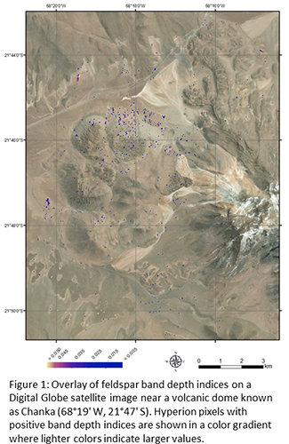
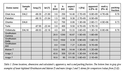
Five Atacama domes were studied from orbit, and three of them were sampled on the field. Dome dimensions as measured on ASTER DEM are presented in Table 1. Previous studies suggest these features were emplaced by monogenetic eruptions and comprise high K dacitic and rhyodacitic rocks [9, 10]. Collected samples are dominated by glass (~60 vol%), and phenocrysts of plagioclase (~20 vol%), hornblende (~7 vol%), biotite (~4 vol%), alkali feldspar (~3 vol%), orthopyroxenes (~1 vol%) and quartz. Dome bulk rock compositions were further determined by ICP-MS/ICP-OES analyzed at the SARM facility in Nancy, France. The bulk compositions of the domes are very similar to each other with SiO2 contents ranging from 66 to 68 wt%.

3. Dome rheology

Rheology, which refers to the flow properties of the lavas, is controlled by magma properties and especially viscosity. Viscosity is a function of multiple parameters such as the temperature, composition, gas content and degree of crystallization. Fluid dynamics laws have been utilized to develop first-order mathematical equations that tie magma viscosity to the geometry of a flow or edifice (e.g., [11]).

To the first order, dome eruptions can be considered as the extrusion of a Bingham fluid (the cooling magma) characterized by a yield strength τ and a plastic viscosity η. By applying similar rheologic equations to the ones in [2-6], the yield strength and apparent plastic viscosity of the Atacama domes has been estimated (Table 1).

In parallel, the non-Arrhenian Newton silicate melt viscosity is calculated using the dome bulk composition as an input in the models of [12] (Table 1). The difference between apparent and liquid viscosity was further used to calculate the packing fraction with the Einstein-Roscoe equation, as in [13] (Table 1).

4. Discussion and Perspectives

We compare viscosity estimates obtained from remote sensing data (apparent viscosity) and sample analyses (liquid viscosity) for the domes and found that they differ by several orders of magnitude (Table 1).

A plausible explanation is that magma viscosity depends on several parameters (see above). The presence of crystals likely played a role in the elevated apparent viscosity values that we obtained, as suggested by the high packing fraction of ~0.7 (very close to the theoretical maximum packing fraction of 0.74), calculated for all domes.

Dacitic domes in the Atacama Desert have aspect ratios, yield strengths and apparent viscosities similar to the G class of lunar domes as reported by [4] (also referred to as highland domes). This class of domes include the Gruithuisen and Mairan edifices where elevated silica contents were previously reported (e.g., [5-14]. We thus argue that the Atacama domes may be a good analog for these lunar domes, which are likely made of felsic rocks, and could represent the source of the lunar granites/rhyolites and zircons found in the Apollo samples.

5. Acknowledgments

Support to JF from the CNES Luna APR, the LUE future leader and the CNRS Momentum program is much appreciated. This work has been also funded by the Comisión Nacional de Investigación Científica y Tecnológica (CONICYT-FONDAP 15090013/Centro de Excelencia en Geotermia de los Andes-Universidad de Chile). OGM and JF are grateful for support from the Claude Gay program of the French embassy in Chile.

6. References

[1] Whitford-Stark J.L. and J.W. Head (1982), Lunar and Planetary Science Conference, 8th, 2705-2724.

[2] Head III J.W., & L. Wilson (1992), Geochimica et Cosmochimica Acta, 56(6), 2,155-2,175.

[3] Wöhler C. et al. (2007), Icarus, 189(2), 279-307.

[4] Lena, R. et al. (2013), Springer Praxis Books.

[5] Wilson L. and J.W. Head (2003), JGR, 108, 5012.

[6] Schnuriger N. et al. (2020), PSS, 185, 104901.

[7] Ito G. et al., (2020), this meeting.

[8] Flahaut J. et al. (2017), Icarus, 282, 152-173.

[9] de Silva S.L. et al. (1994), JGR, 99, B9, 17,805-17,825.

[10] Taussi M. et al. (2019), JVGR, 373, 179-198.

[11] Hulme G. (1974), Geophys. Journal International, 39 (2), 361–383.

[12] Giordano D. et al. (2008), EPSL 271,123–134.

[13] Chevrel M.O. et al. (2013), EPSL, 394, 109-120.

[14] Glotch, T. D. et al. (2011), GRL, 38, L21204.


How to cite: Flahaut, J., González-Maurel, O., Godoy, B., Martinot, M., and Guitreau, M.: The Andean domes as an analog for lunar silicic constructs: Considerations on rheology, Europlanet Science Congress 2020, online, 21 Sep–9 Oct 2020, EPSC2020-756, https://doi.org/10.5194/epsc2020-756, 2020.

EPSC2020-505ECP
Matthew McKinney and Jonathan Mitchell

There are records of past Earth climates that were ice-free all the way to the poles (Barron 1983), which can be described as “hothouse” climates. These hothouse climates can be contrasted with an “all-tropics” planet, where the tropics are defined by the atmospheric dynamics, i.e. the Hadley Cell extent (Faulk et al. 2017). This classification is thus primarily dependent on a planet’s rotation, rather than its ice-free extent or surface temperatures. We investigate the parameter space between Earth and an all-tropics world using the open-source GCM Isca, developed by Vallis et al (2018). We take an Earth analog and perform a parameter sweep in three dimensions: global reservoir depth (1000m, 100m, 10m, 1m, 1cm); global saturation vapor pressure (1.5x current, 1.4x, 1.3x, 1.2x, 1.1x, 1x); and rotation rate (16 days, 8 days, 1 day). The sweep will allow us to explore the effects of surface liquid coverage, atmospheric moisture content, and large-scale atmospheric circulation on an Earth-like climate. In this presentation we provide a status report and analysis of initial findings.

How to cite: McKinney, M. and Mitchell, J.: Investigating the Dynamics of Hothouse Earth Climates with a Simplified GCM, Europlanet Science Congress 2020, online, 21 Sep–9 Oct 2020, EPSC2020-505, https://doi.org/10.5194/epsc2020-505, 2020.