
3D geological model of Rembrandt basin on Mercury and calculation basin infilling volumes
- 1INAF-OAPD, Padova, Italy
- 2University of Padova, Department of Geosciences, Padova, Italy (riccardo.pozzobon@unipd.it)
- 3CISAS, University of Padova, Italy
Rembrandt is a 715 km-diameter basin on Mercury centered at 32.89°S latitude and 87.86°E longitude. This crater constitutes a remarkable example of the stratigraphic variability on Mercury. The uppermost smooth plains of volcanic origin, which are temporally unrelated to the impact event, have been distinguished by the surrounding smooth plains utilizing spectral information. The basin is crosscut by a prominent NE-SW thrust system more than 1000 km long, named Enterprise Rupes (Ferrari et al., 2015; Galluzzi et al., 2015; Semenzato et al., 2020), attributed mainly to crustal shortening induced by global contraction (see Semenzato et al., 2020 and references therein). This consists of a set of lobate scarps and wrinkle ridges with inverse to transpressional kinematics (Massironi et al., 2015).
The aim of this work, as part of the PLANMAP Horizon 2020 project, is to use all the available information on the site to provide a comprehensive 3D model of both the structural setting and the thicknesses of the main units of the Rembrandt basin infilling using explicit modeling approach.
The principle of three-dimensional explicit modelling relies on the creation of 3D surfaces based on geologic observations and constraints. While implicit modelling and its effectiveness rely on the amount of available data both on the surface and the subsurface to provide a mathematical solution that satisfies all the constraints, the explicit geological modelling implies a more extended geologic interpretation based on the available data which is subject to the operator’s experience and is essentially based on the construction of several interpreted cross-sections to be then interpolated generating mesh surfaces. The advantage is that such type of geologic modelling can be applied in areas with scarcity of data, especially related to subsurface constraints.
In the case of the Rembrandt basin, we mainly based our reconstruction on the geo-stratigraphic map and geologic cross-section from Semenzato et al. (2020). Additional constraints, regarding fault kinematics and fault plane geometry, were provided by Galluzzi et al. (2015) and Crane (2020). As a basemap, we used the MESSENGER MDIS global mosaic at 166 m/pixel together with the MDIS global DEM (665 m/pixel), both of them available in the USGS repositories, with the same Lambert Conformal Conic (LCC) projection of the geo-stratigraphic map.
In Rembrandt basin two different infillings - the YIP (Young Interior smooth Plains) and OIP (Older Interior smooth Plains) units - overlay the IT (para-autochtonous intracrater plains) base unit. The thickness of these units was estimated with several methods in Semenzato et al., (2020), among which the presence of impact craters excavating and exposing the inner basin stratigraphy. We used such craters for the construction of the interpreted cross-sections in complement to the one by Semenzato et al., (2020). These were subdivided into two intersecting sub-parallel sets. The interpreted subsurface horizons were used for mesh interpolation together with the geologic contacts between the different units on the surface creating meshes representin ghte top of the YIP, OIP and IT basin infilling units. The volume between them was then calculated.
The structural modelling was carried out using the structural mapping from Semenzato et al., (2020) and Ferrari et al., (2015). The faults’ vergence and their angles were extracted both thanks to the illumination conditions on the image mosaic and topography, to the measurements provided by Galluzzi et al., (2015) on displaced impact craters and to the work by Crane (2020) and Massironi et al., (2015). This way we were able to model the Enterprise rupes thrust geometry, its splays and backthrusts as well as contractional lobate scarps and extensional radial features within the basin infilling units.
Although requiring a certain degree of assumptions especially on planetary bodies, the 3D geomodelling proves to be a useful tool in order to check surface interpretations that might change once set into 3D environment and refine volume calculations and 3D shape of geologic units. Follow up investigations will focus on forward and backwards modeling work on the activity of the Enterprise Rupes system.
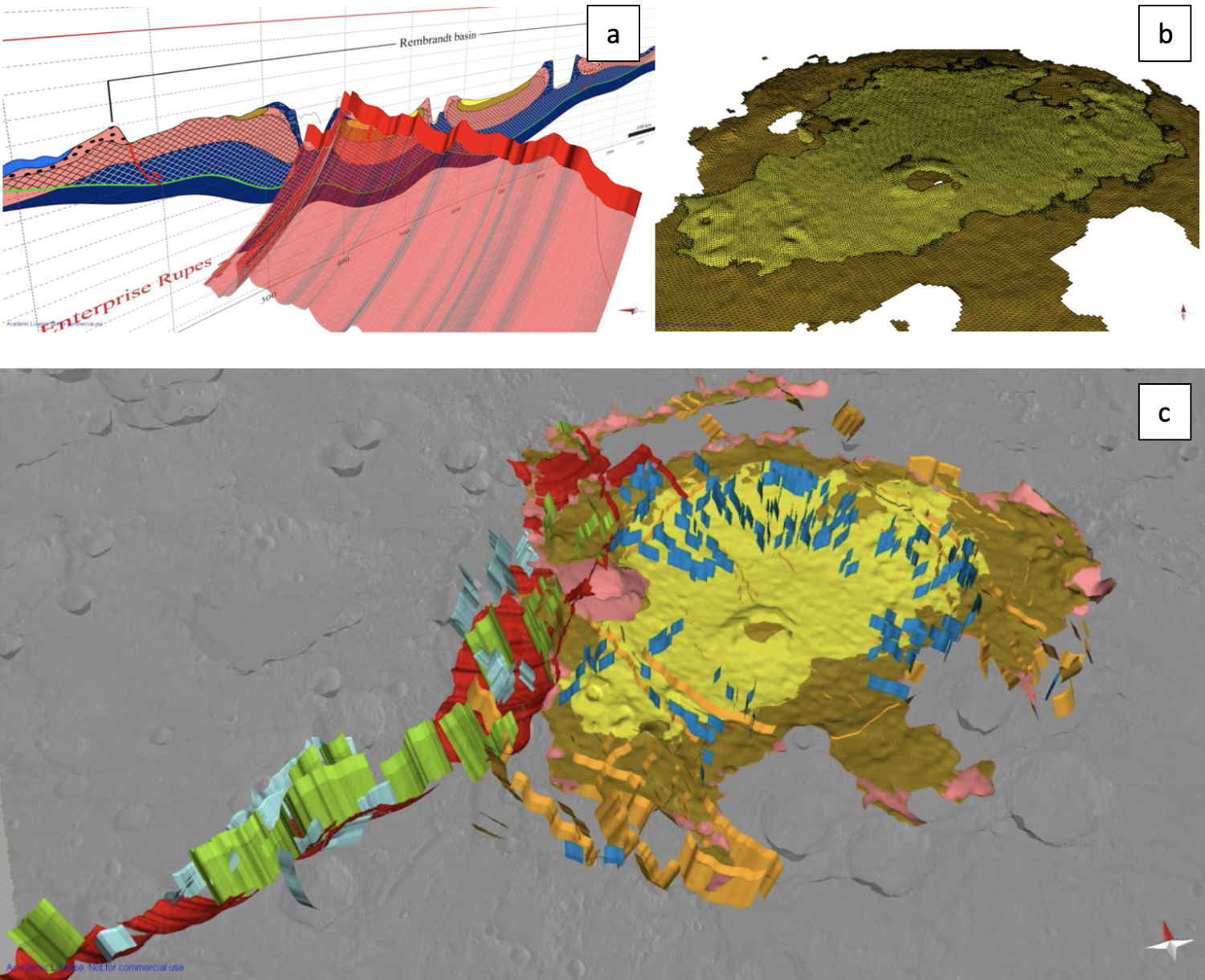
Figure 1: in a) the mesh construction for the main Enterprise rupes structure, constrained with surface mapped lineaments and anchored on the geologic cross-section. In b) the tetrahedral volumetric mesh representing the two events of Rembrandt basin infilling. In c) the structural and stratigraphic geomodel of Rembrandt basin (https://skfb.ly/6ZqtI).
Acknowlegements:
This research was supported by the European Union’s Horizon 2020 under grant agreement No 776276‐PLANMAP.
References:
- Crane, K., 2020. Structural interpretation of thrust fault-related landforms on Mercury using Earth analogue fault models. Geomorphology 369, 107366. https://doi.org/10.1016/j.geomorph.2020.107366
- Ferrari, S., Massironi, M., Marchi, S., Byrne, P. K., Klimczak, C., Martellato, E., & Cremonese, G. (2015). Age relationships of the Rembrandt basin and Enterprise Rupes, Mercury. Geological Society, London, Special Publications, 401(1), 159–172. https://doi.org/10.1144/SP401.20
- Galluzzi, V., Di Achille, G., Ferranti, L., Popa, C., & Palumbo, P. (2015). Faulted craters as indicators for thrust motions on Mercury. Geological Society, London, Special Publications, 401(1), 313–325. https://doi.org/10.1144/SP401.17
- Massironi, M., Di Achille, G., Rothery, D. A., Galluzzi, V., Giacomini, L., Ferrari, S., Zusi, M., Cremonese, G., & Palumbo, P. (2015). Lateral ramps and strike-slip kinematics on Mercury. Geological Society, London, Special Publications, 401(1), 269–290. https://doi.org/10.1144/SP401.16
- Semenzato, A., Massironi, M., Ferrari, S., Galluzzi, V., Rothery, D. A., Pegg, D. L., Pozzobon, R., & Marchi, S. (2020). An Integrated Geologic Map of the Rembrandt Basin, on Mercury, as a Starting Point for Stratigraphic Analysis. Remote Sensing, 12(19), 3213. https://doi.org/10.3390/rs12193213
How to cite: Pozzobon, R., Massironi, M., Penasa, L., and Ferrari, S.: 3D geological model of Rembrandt basin on Mercury and calculation basin infilling volumes , European Planetary Science Congress 2021, online, 13–24 Sep 2021, EPSC2021-749, https://doi.org/10.5194/epsc2021-749, 2021.