
Global Map and Parameter Catalog of Shortening Structures on Mercury Using Novel High-Resolution Topography Data
- 1Arizona State University, School of Earth and Space Exploration, Tempe, United States of America
- 2German Aerospace Center, Institute of Planetary Research, D-12489 Berlin, Germany
- 3Structural Geology and Geomechanics Group, Department of Geology, University of Georgia, Athens, GA, USA
- 4NASA Goddard Space Flight Center, Greenbelt, Maryland, USA
- 5Center for Earth and Planetary Studies, National Air and Space Museum, Smithsonian Institution, Washington, DC, USA
Introduction: The global distribution of shortening structures on Mercury as well as geographic and temporal trends of any of their morphometric and structural parameters are key to better understand the planets’ history of contraction, tidal despinning, and lithologic/rheologic variations in its current crust [1–4]. Previous global cataloging of ~6000 shortening structures on Mercury by [1] was based on preliminary, ~250 m/pixel data by MESSENGER’s Mercury Dual Imaging System (MDIS) and included no morphometric analyses other than displacement-length (D/L) assessments on 665 m/pixel digital terrain models (DTMs) [5]. Furthermore, as recently elaborated on by [6], the association of shortening structures with larger tectonic complexes needs to be assessed to derive a more realistic inventory of actually implied faults. We provide such assessments without interpolating between geographically disconnected structures while maintaining optional association of structural complexes, thereby offering a more versatile dataset (Fig. 1).
Data: Our mapping is carried out on high- and low-incidence angle, ~166 m/pixel mosaics of MDIS images as well as on 222 m/pixel digital terrain models (DTMs) derived from photogrammetric analysis of MDIS-Near-Angle Camera stereo images. While four quadrangles of these DTMs have been released [7–9], we have since finished the remaining 11 quadrangles. Hillshade models and slopemaps derived from these DTMs are also used for feature identification and mapping to minimize any residual illumination bias (especially at certain longitudinal bands) that likely affected previous efforts [1,6] that lacked fully global hi-res topographic data.
Methodology: We established a thorough step-by-step procedure to map and parametrize each identified shortening structure:
- Digitization at scale 1:1,000,000 using streaming method at constant vertex placement every 2 km. Midpoint coordinates and lengths will be automatically recorded.
- Check whether feature had been (entirely or partially) recognized by [1].
- Interpretive assignment to a complex (or none). Nomenclature "[LobateScarp or WrinkleRidge]_Quadrangle name_[closest named feature or official scarp name]#", e.g., "WR_H-03_Brahms01" (quadrangle based on where majority of complex is). All compound scarps associated with a wrinkle ridge are mapped as scarp-like slope breaks but assigned to an according complex with prefix WR.
- Measure maximum width and width at point of maximum offset, i.e., extent of scarp backarc until it reassumes background elevation or distance between front- and backscarp.
- Measure maximum relief (in steps of 50 m, which is the vertical accuracy of the DTMs)
- Determine shape of throw (topographic trend along scarp or ridge crest; only for lengths >20 km).
- Orientations are determined in bulk after completion of a quadrangle. Will be done per entire line feature (avg. orientation) and per 2 km-vertex segment (weighted orientation).
- Lobateness (i.e., ratio between line connecting endpoints and actual feature length) will be determined in bulk after completion of a quadrangle.
- Segmentation (i.e., sum of gap length divided by sum of segment lengths) will be determined per assigned complex.
- Depth of faulting, displacement-length ratios (D/L), and horizontal shortening will be derived per line feature according to methods by[10–15] in bulk after completion of a quadrangle. Maximum values per complex will be recorded. D/L per complex (i.e., max. offset/entire complex length) will also be offered.
- Minimum model ages will be dereived for subset of shortening structures from crater size-frequency distribution measurements on underlying units, e.g., sufficiently large smooth crater floors. Initial assessments indicate 5 to 10 such locations per quadrangle.
Applications: The geographic and temporal distribution of the structural parameters listed above will be used to test a variety of predictions made by several hypotheses, e.g., regarding global contraction, tidal despinning, thermal weakening, mascon subsidence, as well as lithologic/rheologic variations [1,2,6,15–21].
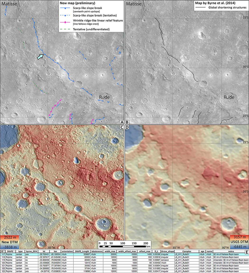
Figure 1: Portion of H-11 quadrangle showing the region between Matisse and Rude craters as preliminary sample area of our structural mapping project. A) Current state of our structural map superposed on low incidence MDIS mosaic. Compared to the linework in (B), we were able to trace the scarp more coherently, also identifying segments on the floor of Rude crater and new structural features elsewhere. The blue-green arrow points to the feature highlighted in (E). B) Same as (A) but with the map by [1]. C) New color-coded DTM over derived hillshade model. D) Same as (C) but using topography data by the USGS [5]. E) Attribute table of our scarp-like slope break linework (blue lines in (A)), including the highlighted one in blue-green (marked by arrow in (A)). Columns show parameters for each line feature. Orientation and lobateness will be derived in bulk at a later point using ArcToolbox plugins. Ages will only be determined for scarps whose formation age can be constrained with CSFD measurements, e.g., when they transect a smooth, sufficiently large crater floor.
References: [1] P. K. Byrne et al., Nat. Geosci. 1 (2014). [2] K. T. Crane and C. Klimczak, Icarus 317, 66 (2019). [3] M. E. Banks et al., J. Geophys. Res. Planets 122, 1010 (2017). [4] M. E. Banks et al., J. Geophys. Res. Planets 120, 1751 (2015).[5] K. J. Becker et al., in LPSC (2016), p. 2959.[6] T. R. Watters, Commun. Earth Environ. 2, 9 (2021).[7] F. Preusker et al., Planet. Space Sci. 142, 26 (2017).[8] A. Stark et al., in LPSC (2017), p. 2287.[9] J. Oberst et al., in LPSC (2017), p. 1442.[10] T. R. Watters et al., Geophys. Res. Lett. 29, 1542 (2002).[11] I. Egea-González et al., Planet. Space Sci. 60, 193 (2012).[12] G. A. Peterson et al., in LPSC (2017), p. 2315.[13] S. F. Wojtal, J. Struct. Geol. 18, 265 (1996).[14] T. R. Watters, R. A. Schultz, and M. S. Robinson, Geophys. Res. Lett. 27, 3659 (2000).[15] P. K. Byrne, C. Klimczak, and A. M. Celâl Şengör, in Mercur. - View after MESSENGER (2018), pp. 249–286.[16] T. R. Watters et al., Geophys. Res. Lett. 42, 3755 (2015).[17] S. A. Hauck et al., in Mercur. - View after MESSENGER (2018), pp. 516–543.[18] R. G. Strom, N. J. Trask, and J. E. Guest, J. Geophys. Res. 80, 2478 (1975).[19] T. R. Watters et al., Geophys. Res. Lett. 31, L04701 (2004).[20] R. J. Phillips et al., in Mercur. - View after MESSENGER (2018), pp. 52–84.[21] T. R. Watters et al., Earth Planet. Sci. Lett. 285, 309 (2009).
How to cite: Bernhardt, H., Clark, J. D., Preusker, F., Klimczak, C., Banks, M. E., Williams, D. A., Nelson, D., and Watters, T. R.: Global Map and Parameter Catalog of Shortening Structures on Mercury Using Novel High-Resolution Topography Data, Europlanet Science Congress 2022, Granada, Spain, 18–23 Sep 2022, EPSC2022-278, https://doi.org/10.5194/epsc2022-278, 2022.