
Regional and Local Geomorphologic Mapping of the Aristarchus Plateau
- Arizona State University, School of Earth and Space Exploration, Tempe, United States of America
Introduction: The Aristarchus Plateau is a unique region on the Moon, hosting its highest concentration of rilles including the widest and deepest rille [1], its most extensive dark mantle deposits [2], as well as rare exposures of both, very olivine-rich and very silicate-rich materials [3–6]. As such, the plateau has been considered as one of the most promising exploration sites apart from the lunar poles for decades [7–10]. To facilitate future in-situ operations and devise traverse plans on the plateau, we are mapping a 285 km2 area centered at 50.53°E 24.51°N, which includes crater Herodotus G, ~27 km northwest of the rim of crater Herodotus (Fig. 1, black outline). For context, and as there exists no dedicated, peer-reviewed map of the Aristarchus Plateau, we are producing a regional map (~103 km2) centered at 50.75°E 26.11°N, encompassing the entire plateau and the Montes Agricola. Here we present a progress report on this regional map (Fig. 1).
Data: A 7 m/pixel mosaic of SELENE (“Kaguya”) Terrain Camera (TC) morning images, i.e., with homogeneous illumination from the east [11] serves as our map base. We also utilize several other datasets (for explanation of abbreviations see references): LOLA-Kaguya (merged topography and derivatives [12]); LROC-WAC (high and low incidence [13]), Clementine (NIR and UV-VIS mosaics [14]); Diviner (rock abundance, CF position, and temperature [15]); Arecibo-Green Bank radar (S-band circular polarization, [16]). Pre-Kaguya/LRO maps including the Aristarchus plateau are also consulted for reference and regional context [17–19].
For our local mapping (Fig. 1, black rectangle), we will also consult three LROC-NAC mosaics (two opposing high incidence and one low incidence [13]) as well as NAC-derived stereo topography [20,21].
Methodology: Regional mapping is carried out at a scale of 1:80,000. Initial identification and digitization of linework and units is conducted on our basemap (Kaguya TC) in conjunction with merged LOLA-Kaguya data (topography, hillshade, and slopemap). Further unit characterization and delimitation is based on all datasets listed in the Data section.
Our regional mapping approach is similar to the composite map by [18]. However, we will map mineralogic units that lack corresponding morphologic or albedo signatures (e.g., olivine-rich areas on the southeastern rim of Aristarchus [3,4] or silicic areas in several specific locations [5,6]) as overlay textures instead of assigning separate units. For our local map we plan a mapping scale of 1:15,000 using LROC-NAC mosaics at different incidence angles as basemaps.
Initial results: We identified 45 potential volcanic collapse structures (irregular pits; IRPs; Fig. 1, red units) ranging in areal extent from ~0.3 km2 to ~110 km2 with a mean at ~7 km2. Most of these structures have not been reported in previous investigations and all but six IRPs are located on the Aristarchus plateau. IRPs were defined as depressions fulfilling at least three of the following criteria: 1) Irregular shape; 2) Anomalous depth-diameter-ratio; 3) Not surrounded by spectral signatures consistent with impact ejecta; 4) Connected to or closely associated with a rille or with a partially breached rim.
In our map, the term “rille” is defined as linear depression indicating a formation by volcanic drainage, i.e., it has to fulfill two of the following criteria: 1) Sinuous trace; 2) Following the topographic gradient; 3) Connected to or closely associated with an IRP. We mapped a total of 100 rilles with total, maximum, and minimum lengths of 1724 km, 110 km, and 0.5 km, respectively. Additionally, we identified 78 highly degraded rilles and segments, for a total rille length of ~2033 km. This includes at least 37 rilles and rille segments that have not been identified in previous investigations [1,18]. We also detected two ~3.7 km long and up to ~24 m high, sinuous ridge segments approaching Rima Krieger. Two more ~2.5 km and ~5 km long sinuous ridges are located north of the Montes Agricola. If these represent inverted rilles, they would triple the number of such features identified on the Moon [1].
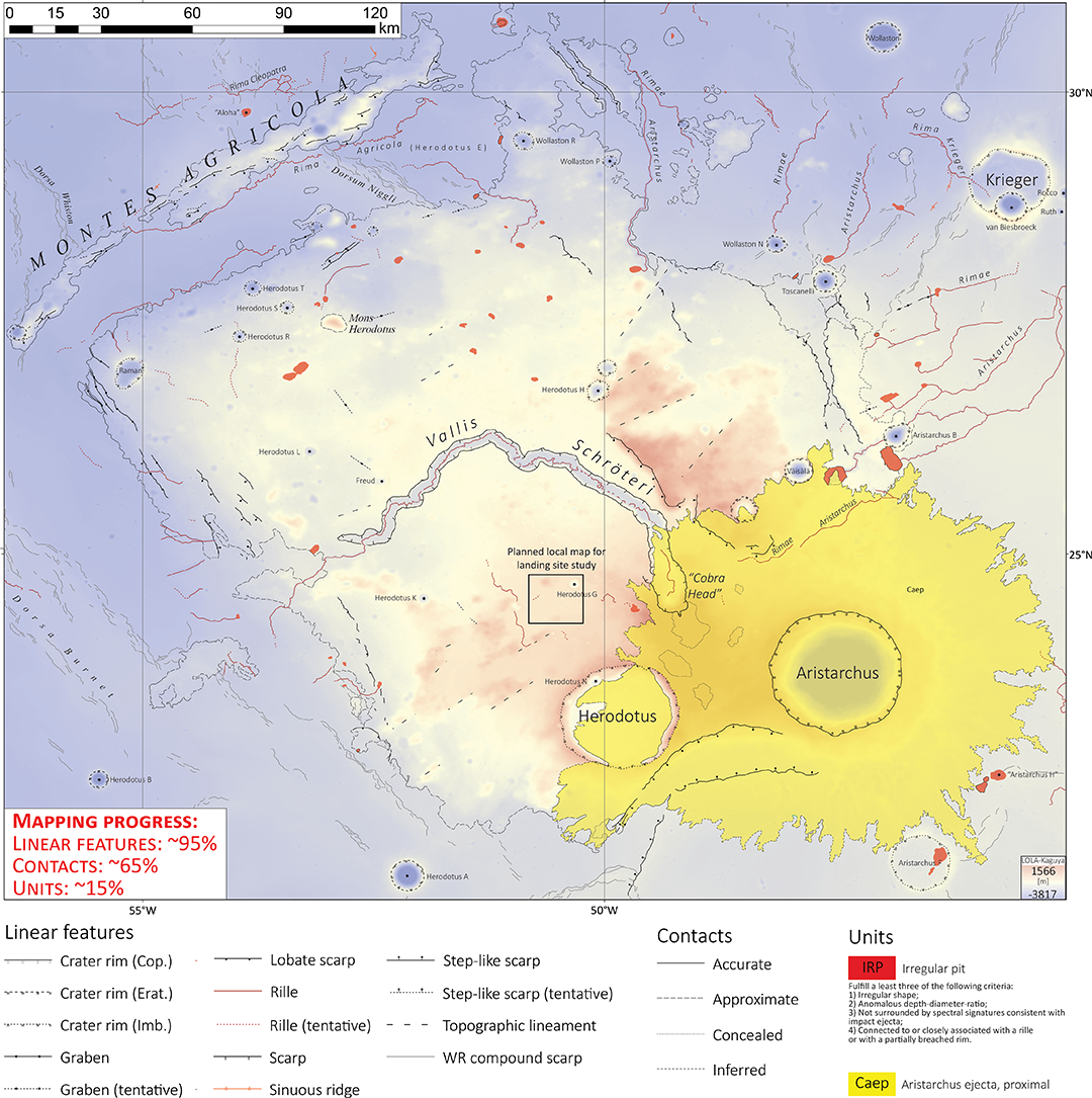
Figure 1: Current state of our regional geomorphologic map of the Aristarchus Plateau (mapping scale 1:80,000); background is the merged LOLA-Kaguya Lunar Digital Elevation Model (LDEM). While preliminary linework is complete, mapping of units has just commenced. The black rectangle south of the image center outlines the area of our local mapping (scale 1:15,000) for potential landing site assessment.
References: [1] D.M. Hurwitz et al., PSS 79–80 (2013) 1–38. [2] L.R. Gaddis et al., Icarus 161 (2003) 262–280. [3] S. Le Mouélic et al., GRL 26 (1999) 1195–1198. [4] J.A. Arnold et al., JGR-P 121 (2016) 1342–1361. [5] P.G. Lucey et al., JGR 91 (1986) 344–354. [6] J.F. Mustard et al., JGR 116 (2011) E00G12. [7] R. O’Connell, A. Cook, NASA Authorization for Fiscal Year 1970, 1969. [8] C.R. Coombs et al., in: Sp. 98, Reston, VA, 1998, pp. 608–615. [9] E. Jawin et al. (2021) Bull. Am. Astron. Soc., 53, . [10] T.D. Glotch et al., Planet. Sci. J. 2 (2021) 136. [11] J. Haruyama et al., Earth, Planets Sp. 60 (2008) 243–255. [12] M.K. Barker et al., Icarus 273 (2016) 346–355. [13] M.S. Robinson et al., SSR 150 (2010) 81–124. [14] A.S. McEwen, M.S. Robinson, Adv. Sp. Res. 19 (1997) 1523–1533. [15] J.L. Bandfield et al., JGR 116 (2011) E00H02. [16] B.A. Campbell et al., Icarus 208 (2010) 565–573. [17] H.J. Moore, USGS I-Map 465, 1965. [18] T.A. Lough et al. (2011) LPS XLII, abstract #2013. [19] H.J. Moore, USGS I-Map 527, 1967. [20] Z.M. Moratto et al. (2014) LPS XLV, abstract #2892. [21] M.R. Henriksen et al. (2015) Second Planet. Data Work., pp. 2–3.
How to cite: Bernhardt, H., Clark, J. D., and Robinson, M. S.: Regional and Local Geomorphologic Mapping of the Aristarchus Plateau, Europlanet Science Congress 2022, Granada, Spain, 18–23 Sep 2022, EPSC2022-280, https://doi.org/10.5194/epsc2022-280, 2022.