
 1,1,2,
- 1Joanneum Research Forschungsgesellschaft mbH, Digital, Graz, Austria (piluca.caballo-perucha@joanneum.at)
- 2VRVis Zentrum für Virtual Reality und Visualisierung Forschungs-GmbH, Vienna, Austria (rnowak@vrvis.at)
- 3DLR Deutsche Zentrum für Luft- und Raumfahrt, Berlin , Germany (Jean-Baptiste.Vincent@dlr.de)
Introduction:
The Double Asteroid Redirection Test (DART [1]) was a NASA space mission that impacted the moonlet of the Didymos binary asteroid (Dimorphos) on 26th of September 2022. The data collected prior to the collision by the spacecraft provided extraordinary information about Dimorphos and has been analysed by several scientists around the world, allowing the extraction of Dimorphos’ characteristic properties before impact, including physical and morphological properties, among others.
The European Hera mission [2] will continue exploring Didymos with a launch scheduled in October 2024. Hera will get the first images of Dimorphos after impact by the end of 2026. Along its trajectory, Hera will be able to deliver precious information about Mars, Deimos and Phobos.
The Austrian contribution to the Hera mission mainly consists of supporting the scientific camera instruments´ teams (TIRI, HSC, AFC, and ASPECT) by reconstructing, visualizing and analysing the data acquired with the different instruments on board. For this purpose, several tools have already been partly developed and will be improved and completed up until arrival for rendezvous with the asteroid in late 2026. For the first phase of the project (April 2023-June 2024) two uses cases were defined, namely Mars-fly-by and Dimorphos visualization and analysis with a 3D-GIS (Geographic Information System). In order to evaluate the tools in the most realistic way, a MARS MOLA shape model [3], the results of the DART mission available on its repository [4] and the Hera planned trajectories (SPICE kernels, [5]) calculated by ESAC in September 2023 were used.
PRo3D-GIS
PRo3D-GIS is the Austrian tool designated to support the instruments´ teams for the evaluation and analysis activities during the mission. The tool is based on PRo3D, an interactive 3D visualization tool to allow planetary scientists to work with high-resolution 3D reconstructions [6] [7]. It has major heritage from ExoMars and Mars 2020, but up to recently only supported single planets. To this end, we extended its capabilities to deal with celestial bodies as required for the Hera mission forming the PRo3D-GIS extension. To work with high-quality reconstructions, Pro3D-GIS uses the Ordered Point Cloud (OPC) format [8].
The visualization elements of PRo3D-GIS can be classified into three groups, namely:
- Structural layer (Digital Elevation Model – DEM)
- Texture layers
- Primary texture layer (ortho image)
- Secondary texture layers (derived products, e.g.: hyperspectral map)
- Annotation layers: comprises observations, annotations and measurements
After adding the 3D reconstructions (from DEM) called surfaces to PRo3D, users associate the surface with the SPICE kernel by assigning it a celestial body and reference frame. Given an observation time, PRo3D aligns all 3D data accordingly and fetches the required data. Depending on the visualization properties configured by the user, PRo3D automatically loads the corresponding layers, computes necessary derived products (such as contour lines) and provides an 3D visualization which can be explored interactively. Supported by the visualization layers (e.g. contour lines) users can author annotations and measurements and create screenshots or author videos.
DART repository data for Dimorphos multilayer OPC
Based on the PRo3D-GIS visualization elements mentioned before, following data were taken from the DART repository and converted into OPC format for visualization and analysis:
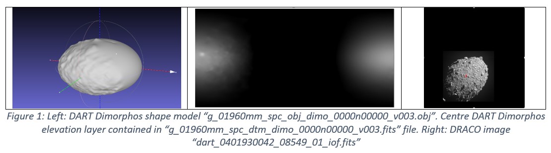
- OPC Dimorphos structural layer: “g_01960mm_spc_obj_dimo_0000n00000_v003.obj”, i.e.: DART Dimorphos shape model (Figure 1, left)
- OPC Dimorphos texture layers:
- OPC primary texture layer: “dart_0401930042_08549_01_iof.fits”, DRACO image which was projected on DART shape model with a projective transformation (Figure 1, right)
- OCP secondary texture layers: “g_01960mm_spc_dtm_dimo_0000n00000_v003.fits”, i.e. 17 DART Dimorphos information layers contained in the FITS file. An example is displayed in Figure 1, centre (i.e.: elevation layer)
Since DART data offers more than one texture layer, the OPC data scheme was enhanced to support them (i.e.: multilayer OPC), and the data import interfaces were adapted. Furthermore, the PRo3D-GIS tool was improved to allow multi-layer analysis and visualization. Additionally, the integration of large coordinates of the celestial bodies’ and the several coordinate systems provided in the SPICE kernels encountered in all mission phases, involved modifications to the design and implementation of PRo3D-GIS.
Visualization and analysis of the use cases
The Hera 3D-GIS has to support the two uses cases proposed for this phase of the development, namely:
- “Mars fly-by,” which main objectives are: The calibration of the instruments on board (e.g.: AFC, HyperScout and TIRI), the possibility to perform science observations of Deimos far side, and the observation of Mars for a couple of hours at good spatial resolution, and for several days with good phase angles
- “Visualization and analysis of Dimorphos” with information provided by the instruments teams, ordered in several information layers, in the validation process using the DART multilayer OPC as simulation example
Mars fly-by
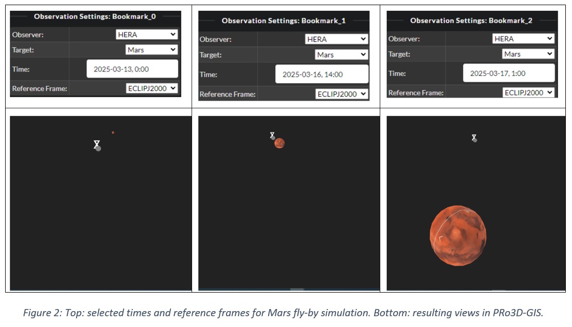
Figure 2 (top) shows three bookmarks selected at different days and times in March 2025 (13th March at 00:00, 16th March at 14:00 and 17th March at 01:00). At the bottom of Figure 2, the approach of Hera (observer, grey colour) to Mars (target, red colour) is visualized. The meta kernel used for this simulation in PRo3D-GIS was “hera_study_PO_EMA_2024.tm” and the reference frame was the ecliptic plane.
Visualization and analysis of Dimorphos
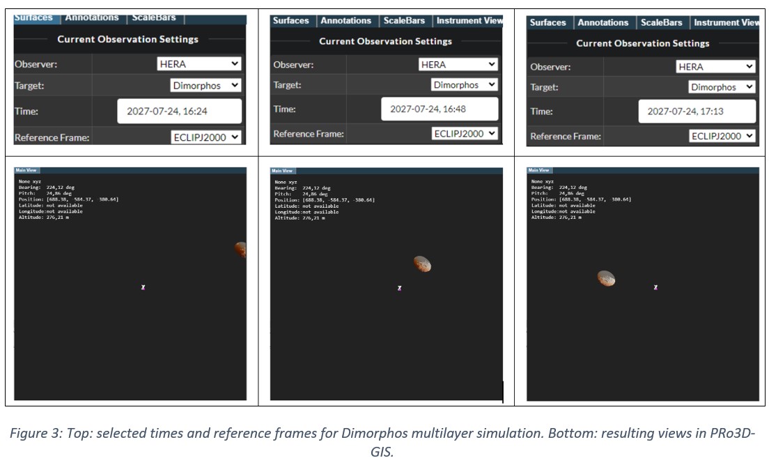
A simulation of the approach of Hera to Dimorphos on 24th July 2027 can be seen in Figure 3. The selected times are shown on the top. At the bottom in the simulated views, Hera is represented as a grey small point in the centre of the image and Dimorphos multilayer in grey and brown colours, due to the combination of two information layers, namely the texture and elevation layers. The meta kernel file used for this simulation was “hera_study_PO_EMA_2024.tm”.
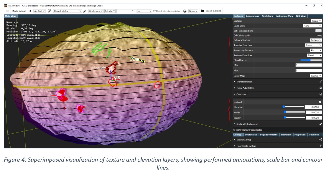
Additional analysis of the Dimorphos multilayer OPC with the available tools of the 3D-GIS was done. Some of the GIS applications available in PRo3D-GIS are shown in Figure 4, namely: layers superimposition visualization, annotations, measurements and scale analysis.
Summary and further work
Acknowledgement

References
[1] https://iopscience.iop.org/article/10.3847/PSJ/ac91cc/pdf
[2] https://iopscience.iop.org/article/10.3847/PSJ/ac6f52
[3] https://tharsis.gsfc.nasa.gov/MolaRcvrPaper.pdf
[4] https://dart.jhuapl.edu/SOC/DRA/
[5] https://s2e2.cosmos.esa.int/bitbucket/projects/SPICE_KERNELS/repos/hera/browse/kernels
[6] https://doi.org/10.1002/2018EA000374
[7] https://doi.org/10.1002/9781119313922.ch3
[8] https://www.researchgate.net/publication/228716045_Towards_True_Underground_Infrastructure_Surface_Documentation
[9] https://www.vrvis.at/publications/pdfs/PB-VRVis-2022-017.pdf
[10] https://www.vrvis.at/publications/pdfs/PB-VRVis-2023-002.pdf
[11] https://meetingorganizer.copernicus.org/EPSC2021/EPSC2021-73.html
[12] https://doi.org/10.5194/epsc2020-123
[13] https://az659834.vo.msecnd.net/eventsairwesteuprod/production-atpi-public/2387daf11cb14198bb064e103ee9747a
How to cite: Caballo-Perucha, P., Nowak, R., Steinlechner, H., Paar, G., Traxler, C., and Vincent, J.-B.: PRo3D-GIS tool for Hera: visualization and analysis of two use cases, Europlanet Science Congress 2024, Berlin, Germany, 8–13 Sep 2024, EPSC2024-322, https://doi.org/10.5194/epsc2024-322, 2024.