Strike-slip tectonics as a precursor to crustal spreading in Anshar Sulcus, Ganymede: Implications for grooved terrain formation
- 1International Research School of Planetary Sciences, Università d’Annunzio, Italy (mafalda.ianiri@unich.it)
- 2Università degli studi Gabriele d'Annunzio, Ingegneria e Geologia, Italy
Introduction
The formation of grooved terrains on the icy surface of Ganymede is still debated and it could involve extensive rifting [1, 2] or spreading [3], strike-slip tectonics [4, 5], and minor cryovolcanic resurfacing [6].
To investigate the origin and evolution of the grooved terrains, we performed a geomorphological and structural analysis of Anshar Sulcus, a grooved terrain located in the anti-Jovian hemisphere within the dark terrain of Marius Regio. In addition, we conducted a topographical analysis producing a Digital Elevation Model (DEM) of this region. We selected Anshar Sulcus because it is a terminal portion of a grooved system, and it was imaged at high resolution by the Galileo SSI. These two aspects helped us to perform a palinspastic reconstruction of the area surrounding the sulcus and, consequently, a reconstruction of the different stages of formation of this sulcus.
Methods
The geological map was produced based on SSI Galileo images having a spatial resolution of about 152 m/px, at 1:500000 scale, using the differences in tones, textures and patterns and DEM. To import these images to the Geographic Information System (GIS), we calibrated, filtered and geo-referenced them through the Integrated Software for Imagers and Spectrometers (ISIS4) [7]. The DEM was produced using the “shape-from-shading” tool (SfS) provided by the NASA Ames Stereo Pipeline tool suite [8], maintaining the same spatial resolution as the images.
Results
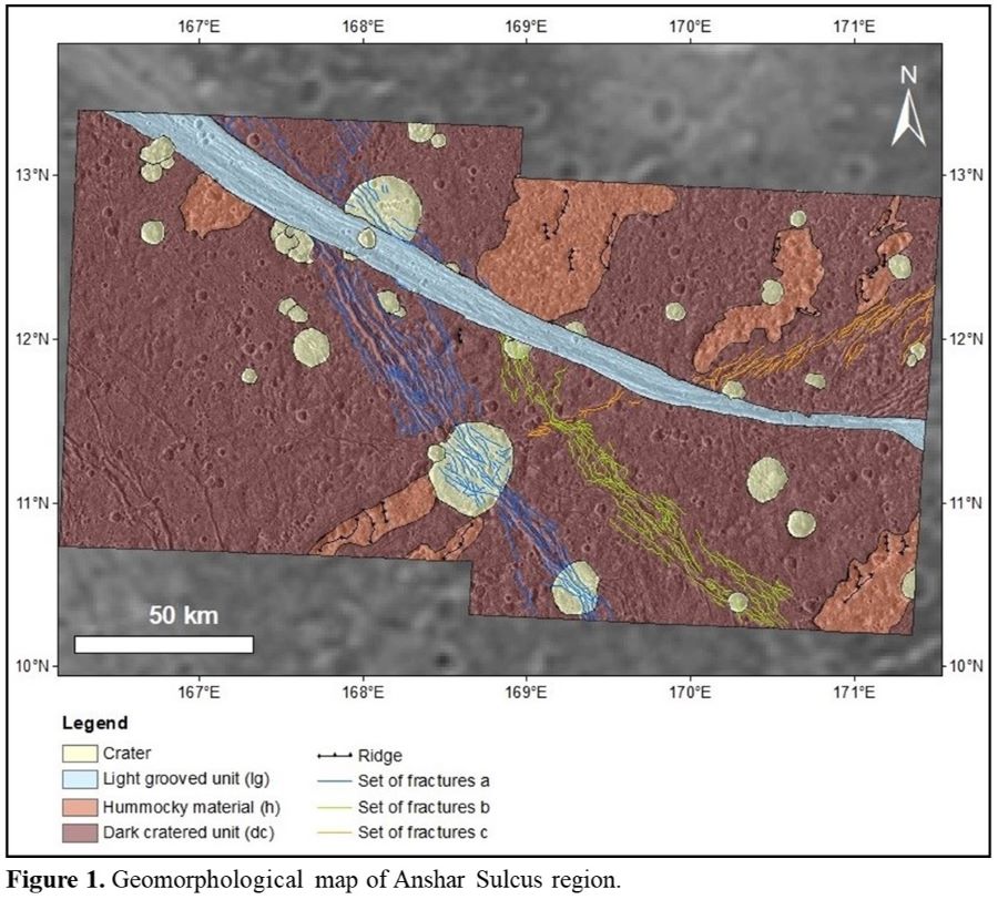
Our geological map (Fig. 1) shows that most of the study area is covered by the dark cratered unit (dc) and consists of a heavily cratered surface with several patches of hummocky material and a pervasive fracturing that we have divided into three main sets. The light grooved unit (lg) consists of a prominent lane that crosscuts the dc characterized by sets of sub-parallel linear grooves. Additionally, topographic profiles traced perpendicular to the sulcus, revealed that the elevation of the grooved terrain increases towards its central part.
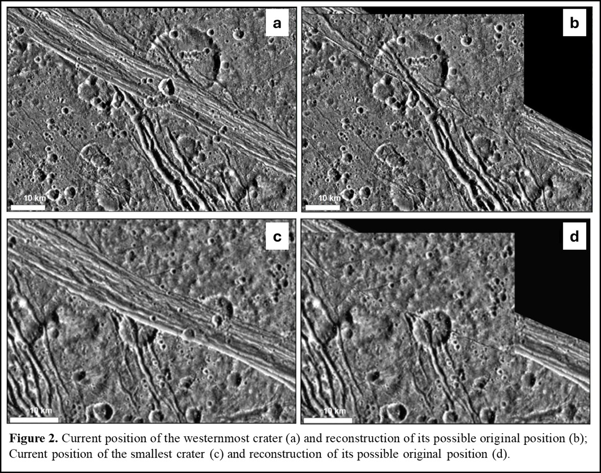
From a morphological observation, we identified well preserved rims of cut craters and fractures along the boundary between the lg and dc. These structures interrupt at the boundary with lg, and this allowed us to reconstruct the possible original position of these structures before the formation of the light unit.
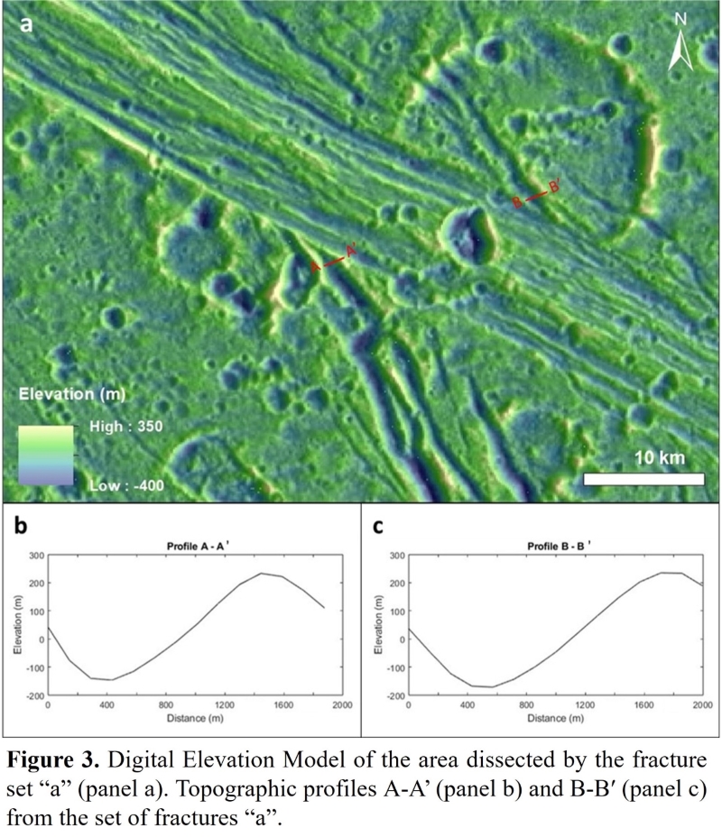
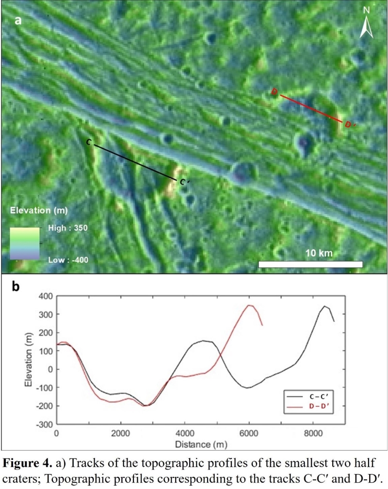
Starting from the westernmost crater along the northern boundary of the dc region (Fig. 2a, 2b), we observed morphological coherence and continuity between the fractures within the crater and the set of fractures in the southern region (set a), suggesting a right lateral displacement of about 15 km. Proceeding to east along the boundaries of the two dc regions, we noted the occurrence of two rims of a possible crater (Fig. 2c, 2d) characterized by a lateral displacement of about 13 km. Moreover, in support of morphological evidence, the topographic profiles traced within the analysed structures show a consistency between the elevations of their southern and northern portions (Figs. 3 and 4).
Discussion
Through a combination of structural and topographic analyses, we have found evidence that the formation of Anshar Sulcus grooved terrain was a result of spreading and upwelling of new material. This is supported by the presence of well-preserved structures along the boundaries between dc and lg, and by the higher topographic elevation at the centre of the sulcus, which rules out the possibility of rifting as the cause of its formation.
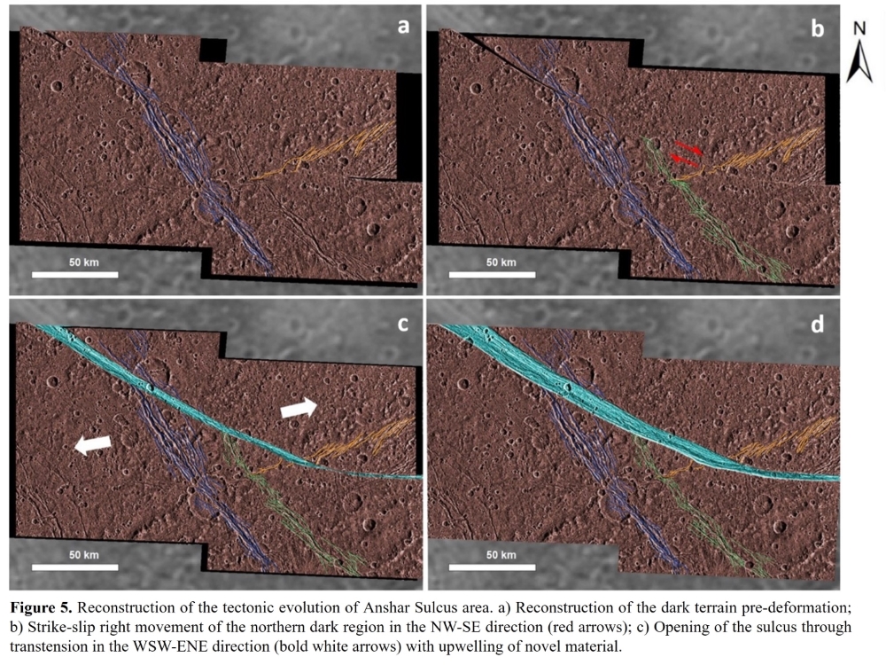
Our reconstruction shows that the first tectonic event was a right-lateral movement in the NW-SE direction (Fig. 5b) that divided the dark terrain of Marius Regio into two distinct regions with conservative margins. The second tectonic stage (Fig. 5c) presents the beginning of the spreading event that caused the separation of the two regions previously formed as consequence of the strike-slip event, corresponding to the formation of light grooved unit. The right lateral strike-slip tectonics continued during the spreading stage, so the separation of the two regions occurred with a transtensional movement toward a WSW- ENE direction.
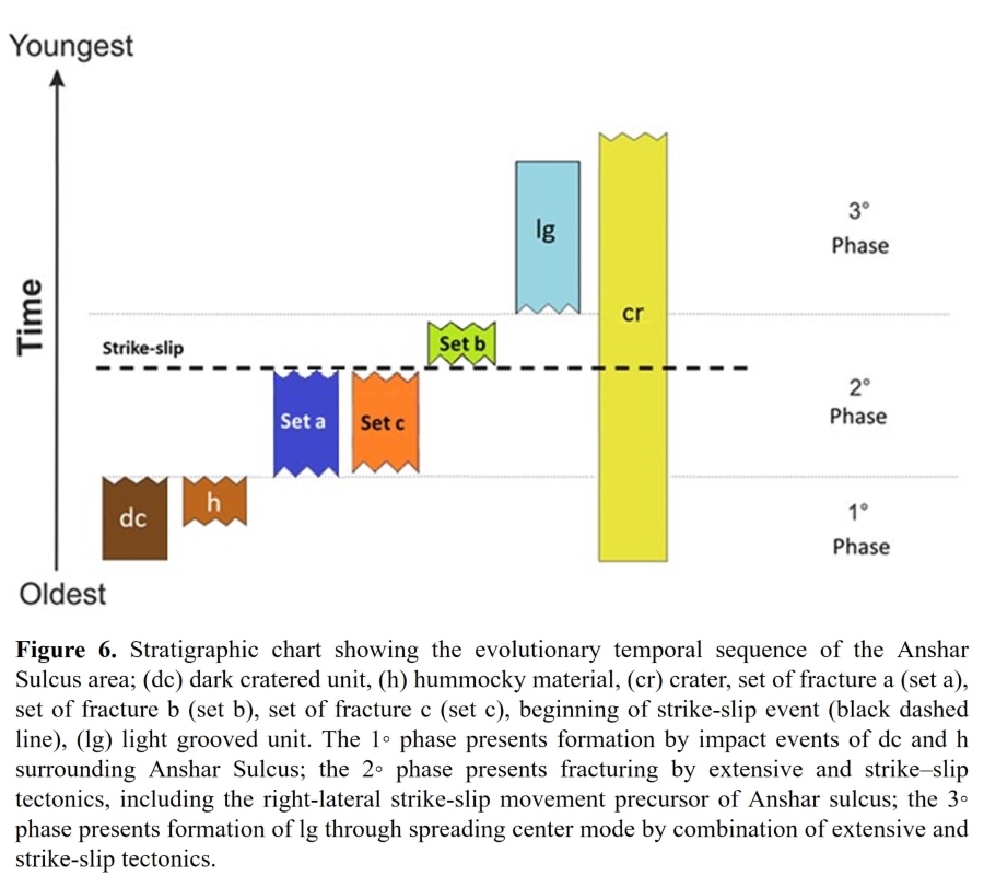
Furthermore, we have compiled a chronostratigraphic chart (Fig. 6) that identifies three stratigraphic phases for the formation of Anshar Sulcus and surrounding area. The first phase is characterized by the formation of the dark unit due to contamination of the icy shell by impactors. The second phase is characterized by the formation of the three sets of fractures and by the start of the strike-slip event that produced the division of the dark terrain of Marius Regio. Finally, the third phase is characterized by the formation of the lg unit through crustal spreading. The formation of the grooves inside the light unit occurred relatively quickly, due to the brittle faulting and tilting of the new crust during the extension event that have formed the light unit, explaining the absence of deformed or displaced craters inside the sulcus.
Conclusions
Our analysis reveals a two-stage tectonic genesis of Anshar Sulcus, with a first strike-slip stage dividing the dark terrain of Marius Regio into two distinct regions, and a second stage characterized by the formation of the grooved terrain of Anshar Sulcus through crustal spreading and upwelling of new, uncontaminated material, with the simultaneous formation of grooves within it due to brittle fracturing.
Acknowledgements
M.I. and G.M. acknowledge support from the Italian Space Agency (2023-6- HH.0).
References
[1] Collins et al. (1998b) Icarus, 135, 345–359.
[2] Prockter et al. (2002) J. Geophys. Res.: Planet. 105, 22519-22540.
[3] Pizzi et al. (2017) Icarus, 288, 148-159.
[4] Pappalardo et al. (1998) Icarus, 135, 276-302.
[5] Cameron et al. (2018) Icarus, 315, 92-114.
[6] Showman et al. (2004) Icarus, 172, 625-640.
[7] Houck and Denicola (2000) ADASS IX, 216, 591.
[8] Beyer et al. (2018) Earth and Space Sci. 5(9), 537–548.
How to cite: Ianiri, M., Mitri, G., Sulcanese, D., Chiarolanza, G., and Cioria, C.: Strike-slip tectonics as a precursor to crustal spreading in Anshar Sulcus, Ganymede: Implications for grooved terrain formation, Europlanet Science Congress 2024, Berlin, Germany, 8–13 Sep 2024, EPSC2024-933, https://doi.org/10.5194/epsc2024-933, 2024.