

- The Institute of Space Technology and Space Applications, Universität der Bundeswehr, Munich, Germany, burakekim0@gmail.com
The escalating global increase in anthropogenic pressure urgently demands consistent and high-resolution monitoring tools. Protecting nature begins with the ability to accurately track where human influence is intensifying and where natural ecosystems remain intact. Until now, the mapping of human influence has relied on traditional methods combining coarse pressure layers (such as nighttime OpenStreetMap, and land cover) with fixed heuristic rules. These input layers are often imperfect, not temporally consistent, and have known representation biases, particularly in the Global South, severely limiting their utility for conservation policy.
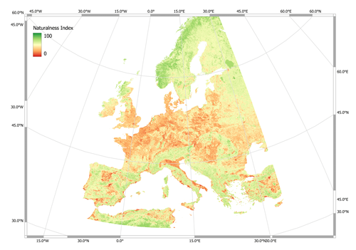
This work proposes the task of Naturalness Mapping from Space. This is an end-to-end geospatial AI framework that learns the complex mapping directly from a single satellite image to quantify the absence of modern human influence.
Our framework first used a feature attribution method adopted from interpretable machine learning domain across multi-modal inputs --including Sentinel-1, Sentinel-2, nighttime lights, and land cover-- to reveal that Sentinel-2 is the most influential modality for the task [1]. Using this insight, we designed a geospatially-aware deep learning model, tailored to EO specifics by conditioning it on geocoordinates and wider spatial context. This results in a high-resolution 10 meters, globally-consistent Naturalness Map, quantifying the degree of human influence.
The final model, deployed at a continental scale, is wrapped by a Distribution Shift Detector [2]. This yields two outputs: the primary Naturalness Map and its accompanying Reliability Map. The Reliability Map shows whether an end-user should trust the model's prediction at a certain area or time, directly quantifying model confidence. This companion product is engineered to increase transparency in AI predictions, ensuring downstream decision-making processes acknowledge model limitations and actively mitigate the risks of misinterpretation stemming from the known biases of initial training data proxies. Our work thus provides a robust, reliable, and trustworthy blueprint for creating large-scale wall-to-wall geospatially-tailored deep learning maps in support of global conservation targets.
[1]B.Ekim,T.T.Stomberg, R.Roscher,M.Schmitt,"MapInWild:A Remote Sensing Dataset to Address the Question of What Makes Nature Wild"in IEEE Geoscience and Remote Sensing Magazine,doi:10.1109/MGRS.2022.3226525
[2]B.Ekim,G.A.Tadesse,C.Robinson,G.Hacheme,M.Schmitt,R.Dodhia,J.M.L.Ferres;Proceedings of the IEEE/CVF Conference on Computer Vision and Pattern Recognition,2025,pp.2290-2299
How to cite: Ekim, B. and Schmitt, M.: Quantifying Anthropogenic Pressure at the Continental Scale from Space: A Transparency-Aware Geospatial Deep Learning Framework, World Biodiversity Forum 2026, Davos, Switzerland, 14–19 Jun 2026, WBF2026-782, https://doi.org/10.5194/wbf2026-782, 2026.