T10 | Poster session 1

T10

Poster session 1
Posters
| Attendance Mon, 16 Sep, 14:30–16:00|Poster area
Mon, 14:30

Posters: Mon, 16 Sep, 14:30–16:00 | Poster area

P1
|
alpshop2024-60
Duje Smirčić, Duje Kukoč, Damir Slovenec, Matija Vukovski, Branimir Šegvić, Tonći Grgasović, Marija Horvat, and Mirko Belak

The opening of the Neotethys Ocean had a major influence on the sedimentary processes of the wider Greater Adria promontory. A stable Early Triassic shallow marine environment was disrupted by coeval tectonic and volcanic activity, peaking during the Late Anisian – Early Ladinian. Consequently, Middle Triassic volcano-sedimentary successions were deposited on top of Lower Triassic shallow-marine carbonates. These successions, recorded in the Southern Alps, the Dinarides, and the Transdanubian range, are interpreted as deposited in grabens/half grabens created by extensional tectonics and filled with products of volcanic activity intercalated with hemipelagic and pelagic sediments. Although the newly formed Middle Triassic rift-related basins were spatially limited, investigated successions from NW Croatia indicate their complex depositional environments with multiple factors controlling sedimentation.

The investigated Middle Triassic successions of NW Croatia are composed of both shallow-marine and pelagic carbonates and radiolarian chert intercalated with volcanic and several types of volcaniclastic lithologies. Shallow-marine carbonates are characterized by dolostone and limestone with algae, foraminifera, sponges, and in places reefal biota. In dolostone, a faint lamination resembling stromatolite can be observed.

Pelagic limestone contains abundant thin-shelled bivalves, calcified radiolarians, rare sponge spicules, and scarce ammonoids of Pelsonian to Illyrian age. In places, medium- to coarse-grained resedimented shallow-water material is present. Well-bedded, red, and often horizontally laminated radiolarian chert yielded radiolarians of late Illyrian-early Fassanian age. Volcanic rocks are geochemically determined as trachy-basalt and andesite-basalt, while several volcaniclastic lithologies are determined in the studied successions. Pietra verde deposits, composed of vitroclastic and crystalloclastic tuffs, represent the dominant volcaniclastic facies. These deposits show normal grading and horizontal lamination. Occasionally, volcaniclastic particles are mixed with pelagic deposits. Trachy-basaltic autoclastites, the second volcaniclastic facies, are found intercalated with pelagic biomicrite and pietra verde deposits. Volcanogenic sandstone and siltstone are found on top of other lithologies. These deposits exhibit a coarsening-upwards sequence and horizontal lamination. The mixing of volcanic and pelagic material is recorded in coarser intervals.

The described successions add to the existence of a coeval carbonate platform area and adjacent deeper basins. Resedimented carbonates indicate erosion, shedding, and gravitational redeposition of an active carbonate platform bordered by the steep normal faults. These same faults could have served as conduits for basaltic magma to reach the surface. Once in the cold marine environment, lava quenched and autofragmented serving as a source for autoclastic deposits. Newly formed clasts were subsequently reworked and redeposited into deeper parts of the basin. Pelagic limestone and radiolarian chert were deposited in a deeper environment by suspension settling in episodes of volcanic standstill. Pietra verde type tuffs were generated by explosive eruptions and deposited in the pelagic environment by gravitational mechanisms and syn-eruptive redeposition. Volcanogenic sandstone and siltstone are interpreted as deposited by turbiditic currents with the material sourced from the reworking of unconsolidated volcanic detritus.

The Middle Triassic differentiation of sedimentary environments in the limited area of the NW Croatia is inferred from specific sedimentary conditions controlled by multiple factors: basinal topography, gravitational processes, reworking and redeposition, availability of source material, and active tectonic/volcanic processes.

How to cite: Smirčić, D., Kukoč, D., Slovenec, D., Vukovski, M., Šegvić, B., Grgasović, T., Horvat, M., and Belak, M.: Rift-related differentiation of sedimentary environments: a case study from the Middle Triassic of NW Croatia, 16th Emile Argand Conference on Alpine Geological Studies, Siena, Italy, 16–18 Sep 2024, alpshop2024-60, https://doi.org/10.5194/egusphere-alpshop2024-60, 2024.

P2
|
alpshop2024-7
Marian Janák, Igor Petrík, Dušan Plašienka, and Nikolaus Froitzheim


The Central Western Carpathians represent a tectonic system that extends eastward from the Alps and may be well correlated with the Austroalpine units of the Alps. The pre-Tertiary complexes of the Central Western Carpathians originated during the Cretaceous collisional events following the closure of the Meliata ocean by Late Jurassic times. Alpine metamorphism, related to the development of a metamorphic core complex during Cretaceous orogenic events, has been recognised in the Veporic unit (Janák et al. 2001). Increasing P-T conditions from greenschist to middle amphibolite facies reflect a coherent metamorphic field gradient. The isograds are roughly parallel to the north-east dipping foliation related to extensional updoming along low-angle normal faults, 40Ar/39Ar data constrain the timing of cooling and exhumation in the Late Cretacous. To constrain the timing of prograde metamorphism we dated monazite using electron microprobe. One reason for that is a shortage of geochronological data on Alpine metamorphism from the polymetamorphosed rocks which include pre-Alpine, mostly Variscan relicts. The dated monazite occurs in semi-pelitic schists of the highest grade Alpine metamorphic zone, exposed from the deepest levels of the Veporic dome. The peak metamorphic assemblage consists of garnet + biotite + muscovite + paragonite + rutile + quartz. Garnet occurs as clusters involving the fragments of fractured (pre -Alpine) garnet, and newly-formed, idioblastic Alpine garnet. Alpine garnet is zoned with decreasing Ca (XGrs = 0.23-0.16) and increasing Mg (XPrp = 0.05-0.12) from the core to the rim. Thermodynamic modelling indicates that Alpine garnet was growing during the burial (up to 1.2-1.4 GPa; 580-600°C). The metamorphic P-T-t path is “clockwise”, reflecting post-burial decompression (down to 0.8-0.1; 600-610°C) and cooling during Alpine orogenic cycle. Monazite (30-50 µm in size) occurs in the matrix occasionally associated with allanite (REE-epidote) and xenotime, suggesting monazite formation via allanite breakdown during the prograde P-T path. Chemical Th-U-Pb dating yielded Cretaceous age of 95.8 ± 2.7 Ma (MSWD = 1.13) with point ages ranging from 75 to 124 Ma. Similar age of 97 Ma was reported from the ICP-MS dating of monazite in a lower grade chloritoid-kyanite schists. This timing is in  excellent agreement with metamorphism between c. 100 and 90 Ma in the  Eo-Alpine HP/UHP belt in the Austroalpine Nappes of the Eastern Alps (Miladinova et al. 2022). We argue that the Veporic Unit represents direct continuation of the Eo-Alpine high-pressure belt into the West Carpathians.


Janák, M., Plašienka, D., Frey, M., Cosca, M., Schmidt, S. T., Lupták, B. & Méres, Š. 2001. Cretaceous evolution of a metamorphic core complex, the Veporic unit, Western Carpathians (Slovakia): P-T conditions and in situ 40Ar/39Ar UV laser probe dating of metapelites. Journal of Metamorphic Geology, 19, 197-216.


Miladinova, I., Froitzheim, N., Nagel, Th., Janák, M., Fonseca, R.O.C., Sprung, P. & Münker, C. 2022. Constraining the process of intracontinental subduction in the Austroalpine Nappes: Implications from petrology and Lu-Hf geochronology of eclogites. Journal of Metamorphic Geology 40, 423-456.

How to cite: Janák, M., Petrík, I., Plašienka, D., and Froitzheim, N.: Alpine (c. 96 Ma) metamorphism revealed by monazite dating in the Veporic unit, Western Carpathians, 16th Emile Argand Conference on Alpine Geological Studies, Siena, Italy, 16–18 Sep 2024, alpshop2024-7, https://doi.org/10.5194/egusphere-alpshop2024-7, 2024.

P3
|
alpshop2024-33
Matteo Simonetti, Antonio Langone, Mattia Bonazzi, Corvò Stefania, and Matteo Maino

In the last decade, studies of rifted margins have benefited from an increasing quantity of high-quality data from several disciplines. The Ivrea-Verbano Zone (IVZ), in the Italian Southern Alps, represents a complete section of middle to lower continental crust, which records both the Variscan and subsequent Alpine Tethys rift-related tectonics (Beltrando et al., 2015; Simonetti et al., 2023).

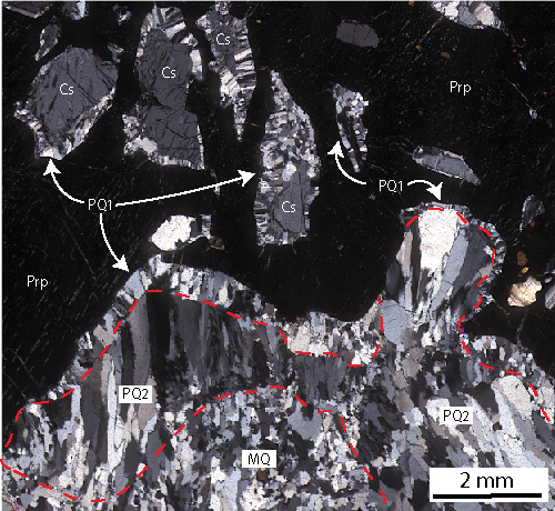
One of the most important structures is the Forno-Rosarolo shear zone (Siegesmund et al., 2008). It is a NE-SW-oriented, subvertical shear zone made of metapelites, amphibolites, calc-silicates and granulites involved in anastomosed proto- to ultra-mylonite layers enveloping weakly deformed lenses. Mylonites formation postdate Variscan metamorphism and deformation and predate Jurassic brittle fracturing and faulting.

In present day orientation, the kinematic indicators point to a sinistral sense of shear. Removing the Alpine tilt at high angle of the IVZ, this kinematic points to a former extensional shear zone. Investigations on the mylonitic flow kinematic reveal a non-coaxial deformation characterized by dominant pure shear (between 70 % and 50 %) and minor simple shear. Metamorphic conditions of the wall rocks vary from the upper amphibolite (SE, footwall) to the granulite facies (NW, hanging wall). Within the mylonites, PT estimate from mineral assemblage points to amphibolite facies conditions during deformation (~650 °C and ~5.5 kbar).

Such kinematic data and metamorphic conditions allow to constrain the development of the Forno-Rosarolo shear zone mylonitic deformation, together with other similar structures of the IVZ, during the intermediate phase of the Tethyan rift (Beltrando et al., 2015; Simonetti et al., 2023) known as “thinning mode” (Manatschal et al., 2007). This stage was characterized by general shear conditions (pure shear between 70 % and 50 %) suggesting a phase of transition from a symmetric to an asymmetric configuration of rift.

Beltrando M., Stockli D.F., Decarlis A., Manatschal G., 2015. A crustal‐scale view at rift localization along the fossil Adriatic margin of the Alpine Tethys preserved in NW Italy. Tectonics, 34, 1927–1951. https://doi.org/10.1002/2015TC003973

Manatschal G., Müntener O., Lavier L.L., Minshull T.A., Péron-Pinvidic G., 2007. Observations from the Alpine Tethys and Iberia–Newfoundland margins pertinent to the interpretation of continental breakup. Geol. Soc. Spec. Publ., 282, 291–324. https://doi.org/10.1144/SP282.14

Siegesmund S., Layer P., Dunkl I., Vollbrecht A., Steenken A., Wemmer K., Ahrendt H., 2008. Exhumation and deformation history of the lower crustal section of the Valstrona di Omegna in the Ivrea Zone, southern Alps. Geol. Soc. Spec. Publ., 298, 45–68. https://doi.org/10.1144/SP298.3

Simonetti M., Langone A., Bonazzi M., Corvò S., Maino M., 2023. Tectono-metamorphic evolution of a post-variscan mid-crustal shear zone in relation to the Tethyan rifting (Ivrea-Verbano Zone, Southern Alps). Journal of Structural Geology, 173, 104896. https://doi.org/10.1016/j.jsg.2023.104896

How to cite: Simonetti, M., Langone, A., Bonazzi, M., Stefania, C., and Maino, M.: Evolution of a post-Variscan mid-crustal shear zone in relation to the Tethyan rifting (Ivrea-Verbano Zone, Southern Alps), 16th Emile Argand Conference on Alpine Geological Studies, Siena, Italy, 16–18 Sep 2024, alpshop2024-33, https://doi.org/10.5194/egusphere-alpshop2024-33, 2024.

P4
|
alpshop2024-61
Stefano Piccin, Silvia Favaro, Luca Minopoli, Stefano Poli, Gianluca Sessa, Massimo Tiepolo, Luca Toffolo, Simone Tumiati, and Stefano Zanchetta

The Oetztal-Stübai Complex (OSC) of the Eastern Austroalpine domain is a polymetamorphic unit extending between western Austria (Tyrol) and northern Italy (Autonomous Province of Bozen/Bolzano). The OSC is made of crystalline basement consisting of metasedimentary rocks (paragneisses and micaschists) hosting numerous bodies of metagranitoids and metabasic rocks, along with subordinate metacarbonates and ultramafics of igneous origin. The Alpine metamorphism in the OSC increases from the north-west to the south-east (Purtscheller & Rammlmair, 1982). 

Pre-Alpine evolution of the OSC is testified by the crystallization of Cambrian mafic-to-ultramafic cumulates with MORB-like signatures preserved in pods and layers within the Central Metabasite Zone (CMZ) (Miller & Thöni, 1995; Konzett et al., 2005); an Ordovician high temperature event resulting in intrusions of granitoids and metapelites anatexis (e.g. Winnebach migmatites); occurrence of Variscan eclogites within the CMZ and subsequent pervasive re-equilibration under amphibolite facies conditions. However, structural relationships in the field do not rule out the possibility of a pre-Variscan HP event.

Extensive field work, microstructural and petrological analyses, and radiometric dating are being carried out in two key areas, Längenfeld and Reschenpass/Passo Resia. The two areas are similar in the occurrence of two Ordovician intrusions, the Sulztal type-S granite (Längenfeld) and the Klopaier Tonalite (Reschenpass), for which we obtained by U-Pb LA-ICP-MS dating of zircons ages of 482.4 ± 1.5 Ma and 460 ± 0.83 Ma, respectively. 

In the Längenfeld area, rocks belonging to the CMZ show various degrees of metamorphic reactions progress often resulting in symplectitic relationships. Mafic-to-ultramafic rocks, with exceptionally well preserved cumulitic textures, display the destabilization at high pressure conditions of anorthite-rich plagioclase to omphacite+corundum intergrowths bordered by garnet, replacing plagioclase as confirmed by REE patterns determined by in-situ LA-ICP-MS. Within these cumulates, newly discovered troctolitic layers show corundum-bearing coronas around olivine and granoblastic textures with increased anorthite content in plagioclase rims, implying a static phase of high temperature recrystallization. Associated metacarbonates are characterized by olivine (Mg/(Mg+Fe)=0.95) and Fe-spinel.

Additionally, we found evidence of partial melting involving metapelites and eclogites of the CMZ, resulting in corundum-bearing migmatitic gneisses and eclogite-derived melts. The Variscan age of CMZ eclogites has been assessed by Sm-Nd mineral and WR isochrons in Miller & Thöni (1995), but unpublished U-Pb zircon data (Sollner & Gebauer in Hoinkes & Thöni, 1993) points to an age of 497 Ma for this high pressure event. This hypothesis deserves further investigations on account of our field work and newly discovered field relationships, suggesting the existence of a pre-Variscan high temperature event post-dating an older eclogite facies metamorphism. 


References:
Hoinkes G & Thöni M (1993) Pre-Mesozoic Geology in the Alps, 485–494
Konzett J et al. (2005) Journal of Petrology 46 (4), 717–747
Miller C & Thöni (1995) Chemical Geology 122 (1) 199–225
Purtscheller F & Rammlmair D (1982) Tschermaks Petr. Mitt. 29 (3), 205–221 

How to cite: Piccin, S., Favaro, S., Minopoli, L., Poli, S., Sessa, G., Tiepolo, M., Toffolo, L., Tumiati, S., and Zanchetta, S.: Pre-Variscan evolution and high temperature metamorphism of the Oetztal-Stübai Complex (Eastern Alps) , 16th Emile Argand Conference on Alpine Geological Studies, Siena, Italy, 16–18 Sep 2024, alpshop2024-61, https://doi.org/10.5194/egusphere-alpshop2024-61, 2024.

P5
|
alpshop2024-67
giancarlo Molli and Ivan Zibra

The Santa Lucia Nappe is a continental-derived unit exposed East of Corte, in central Alpine Corsica (Durand Delga 1984; Rossi et al., 1996).  The unit includes a peculiar lower- to mid-crustal section, exposing mafic and felsic granulites, with an overall structure, Permian age of tectono-metamorphic and magmatic history (Caby et al., 2002; Zibra et al, 2010, 2012), like that of the Ivrea Zone (northwestern Alps), and of the Sila-Stilo unit in the Calabria terrane (Molli et al., 2020). Moreover, the Santa Lucia Nappe includes a Cretaceous metasedimentary cover, with a basal conglomerate transitioning to a calcareous flysch, which shows affinities with calcareous-marly Ligurian Flysch (Amaudric Du Chaffaut 1972; Rieuf 1980). The Santa Lucia Nappe recorded a polyphase Alpine tectonic evolution, developed under greenschist-facies conditions (Zibra, 2006; Vitale-Brovarone et al., 2013)

Because of its unique lithological association, the structural position, significance, and paleotectonic attribution of the Santa Lucia Nappe are  the subject of a long-standing debate. These topics are here re-discussed, based on our data collected in the last two decades of field work.

Our observations allow: (i) to document the Alpine deformation structures affecting both basement and cover sequence, their styles and distribution; (ii) to analyze the structural characters and kinematics of its basal tectonic contacts; (iii) to confirm its tectonic position with respect to the “Schistes Lustres”- composite Nappe system; and, finally, (iv) to propose an original interpretation of its internal architecture. The latter results from the tectonic inversion of pre-Cretaceous high-angle faults, which were originally arranged in an east-dipping, domino-like system, which affected the already exhumed and exposed basement, formerly part of a Permian regional-scale transtensional shear zone.

How to cite: Molli, G. and Zibra, I.: The Santa Lucia Nappe (Alpine Corsica): paleotectonic heritage and deformation history, 16th Emile Argand Conference on Alpine Geological Studies, Siena, Italy, 16–18 Sep 2024, alpshop2024-67, https://doi.org/10.5194/egusphere-alpshop2024-67, 2024.

P7
|
alpshop2024-14
Matthieu Roà, Gianni Balestro, Carlo Bertok, Andrea Festa, Marco Gattiglio, and Chiara Groppo

The internal sector of the Western Alpine axial belt consists of Paleozoic basement units and minor Mesozoic cover successions, which are more widespread in the frontal part of the accretionary wedge. The Europa-derived Internal Crystalline Massifs, in their present-day dome-shaped exposure, consist of pre-Variscan basements hosting Permian intrusive bodies, while remnants of the Mesozoic cover occur discontinuously only along the flanks of the domes. This is also the case of the Dora-Maira Massif (DMM), a stack of different tectonic units metamorphosed under different peak pressure-temperature (P-T) conditions during the Alpine metamorphic cycle. The Triassic to Jurassic cover successions of the DMM basement are detached in the southernmost sector (Balestro et al., 2022) and tectonically sliced along the western flank of the dome in the central sector. In the northern sector of the massif, the basement-cover relationships are more ambiguous, having been represented either as tectonic or as stratigraphic in different geological maps.

We investigated the tectonostratigraphic relationships in the northernmost sector of the DMM in the Susa Valley, by analysing two detailed lithostratigraphic and structural sections across the basement-cover interface. The basement consists of polycyclic garnet- and chloritoid-bearing micaschist with bodies of metabasite and monocyclic orthogneiss, whereas the cover succession mainly consists of Middle Triassic dolomitic marble with minor calcschist of supposed Jurassic age. Both the Paleozoic and Mesozoic rocks were deformed during four main Alpine deformation phases corresponding to the subduction-related D1 phase and the early (i.e., D2) to late (i.e., D3 and D4) exhumation-related phases.

The investigated basement-cover interface is currently represented by a tectonic mélange, varying in thickness from a few meters to tens of meters, mixing tectonic slices of different sizes and lithologies (i.e., monocyclic carbonate-bearing micaschist, vacuolar dolomitic marble and carbonate tectonic breccia, marble, quartzite and quartz-rich schist, gneiss and garnet- and chloritoid-bearing micaschist). The occurrence of this mélange highlights the tectonic nature of the basement-cover interface, which (i) involved lithologies sourced from the Paleozoic basement and the Mesozoic carbonate cover and (ii) is localized along relatively weak metasediments similar to those occurring in the adjoining Briançonnais successions, which are considered Late Permian to Early Triassic in age. The tectonic mélange is deformed by late exhumation-related D3 and D4 folds. Ongoing investigations are focused on better defining when (t) and under which metamorphic conditions (P-T) the mélange was formed.


Balestro G., Festa A., Cadoppi, P., Groppo, C. & Roà M. (2022) - Pre-Orogenic Tectonostratigraphic Evolution of the European Distal Margin-Alpine Tethys Transition Zone in High-Pressure Units of the Southwestern Alps. Geosciences 2022, 12, 358.

How to cite: Roà, M., Balestro, G., Bertok, C., Festa, A., Gattiglio, M., and Groppo, C.: Basement-cover tectonostratigraphic relationships in the northern Dora-Maira Massif (Western Alps), 16th Emile Argand Conference on Alpine Geological Studies, Siena, Italy, 16–18 Sep 2024, alpshop2024-14, https://doi.org/10.5194/egusphere-alpshop2024-14, 2024.

P8
|
alpshop2024-19
Tim Sotelšek, Marian Janák, Sorour Semsari Parapari, Nik Gračanin, Sašo Šturm, and Mirijam Vrabec

The metasedimentary rocks from the Pohorje Mountains (Slovenia) are predominantly gneisses, which represent parts of the Austroalpine metamorphic units of the Eastern Alps. The peak P-T conditions experienced during subduction in the Cretaceous orogeny reached UHPM in the diamond stability field [1, 2 and references therein]. The garnet porphyroblasts contain numerous fluid, solid and polyphase inclusions, among which diamonds have also been found. To better understand the conditions of diamonds formation, their internal structure was investigated. Advanced high-resolution (scanning) transmission electron microscopy (HR(S)TEM) techniques were applied, including high-angle annular dark-field (HAADF-STEM), combined with EDS and electron energy loss spectroscopy (EELS). The TEM lamella was prepared with FIB/SEM technique. Atomic scale resolution was achieved, allowing thorough analysis of diamond.


The investigated lamella contained three diamond grains, which was also confirmed by EELS and EDS analysis. Contacts between the diamond grains and the host garnet are closely intergrown but show no crystallographic relations. Selected area electron diffraction patterns (SAED) of individual diamond grains show that one of the grains is monocrystalline, while the others are polycrystalline. The latter exhibit some preferential orientation of the crystallites. The high-resolution imaging allowed to recognise the structures of the polycrystalline grains at the atomic scale. They consist of numerous nanocrystallites ranging in size from a few to several tens of nanometres in size. Some of them exhibit an undisturbed internal structure, while the others show some imperfections in the form of stacking faults, twins, and lattice dislocations. In addition, a detailed HRTEM study of the polycrystalline diamonds revealed the presence of carbon domains in the form of graphite, which was confirmed with the SAED. Furthermore, in certain areas between the nanocrystalline grains and host garnet, an amorphous layer with a composition close to garnet was identified. Monocrystalline diamond appears without internal defects or graphitic domains and is completely crystalline.


The presence of both monocrystalline and polycrystalline grains in a single inclusion is puzzling in terms of their crystallisation conditions. A change in physical (pressure, temperature) and/or chemical parameters (interaction of the trapped COH fluid with garnet) in the inclusions during metamorphism might induce the precipitation of diamonds with different structures. We hypothesise that the diamonds precipitated in response to changing P-T conditions during the prograde phase of metamorphism, when the solubility of C in COH fluids decreases. Absence of standalone prograde graphitic grains indicates that the C saturation was achieved in the diamond stability field. At first, before reaching peak metamorphism, monocrystalline diamond was formed. After reaching peak metamorphism, though still in the diamond stability field, the COH fluid began to interact with the walls of the garnet enabling precipitation of the amorphous phase, after which polycrystalline diamonds formed. The graphitic domains within the diamond nanocrystallites were formed due to transition from the diamond to the graphite stability field during exhumation of the rock. To draw more precise conclusions, further investigations need to be carried out.


References

1. M. Vrabec et al., Lithos, 2012, 144, 40–55.

2. M. Janák et al., J. Metamorph. Geol., 2015, 33, 495– 512. 

How to cite: Sotelšek, T., Janák, M., Semsari Parapari, S., Gračanin, N., Šturm, S., and Vrabec, M.: Diamonds formation revealed by their internal structure: a case study from Pohorje, Eastern Alps, Slovenia, 16th Emile Argand Conference on Alpine Geological Studies, Siena, Italy, 16–18 Sep 2024, alpshop2024-19, https://doi.org/10.5194/egusphere-alpshop2024-19, 2024.

P9
|
alpshop2024-21
Davide Dana, Francesco De Cesari, Chiara Montomoli, Salvatore Iaccarino, Daniela Rubatto, Simone Lenci, Alberto Corno, and Rodolfo Carosi

Recent investigations in the northwestern part of the Dora-Maira Massif (Nosenzo et al., 2024 and references therein) shed new light on the structural architecture and metamorphism of its tectonic units, with the discovery of a new UHP unit. Despite these efforts, many open questions remain regarding the structural architecture and tectono-metamorphic evolution of this basement. In this contribution, we present preliminary data from an area located between the Tredici Laghi and Conca Cialancia natural park (Germanasca - Pellice Valleys), a so far poorly explored mountainous region. This area consists of a polycyclic basement composed of micaschist, orthogneiss, paragneiss, marble and metabasite. The structural setting of the area has been reconstructed using a new structural map and geological cross-sections carried out in the framework of the CARG mapping project (Sheet 172 –“Pinerolo”). Microtectonics studies and preliminary P-T-t data have been integrated to tentatively provide a more complete picture of the tectono-metamorphic evolution of the studied area.

Geochronological analyses (U-Pb dating on zircon) allow the recognition of several generations of orthogneiss, with locally preserved overlapping relationships in the field, whose ages range from Early to Late Ordovician. The Alpine structural evolution of the area has been deduced from the correlation of the P-T path with the microstructures. The S1 foliation, rarely preserved in microlithons, developed during prograde P-T conditions and is associated with the syn-kinematic recrystallization of phengite, paragonite, chloritoid, garnet, rutile and probably sodic amphibole (currently pseudomorphsed by albite and chlorite). A subsequent S2 foliation (defined by a second generation of phengite, paragonite, chloritoid, garnet with epidote, ilmenite, albite and minor chlorite) developed along E-W trending lineation-parallel folds. D2 deformation is very heterogeneous: a mylonitic fabric is present in high-strain domains, whereas local pre-Alpine features are preserved in low-strain domains (as already documented elsewhere by Nosenzo et al., 2022). The D3 event is associated with the development of a local S3 foliation, parallel to the axial planes of open NW-SE trending folds and deforms all the previous structures. The S3 foliation is associated with metamorphic re-equilibration in greenschist facies. Several examples of superimposed D2 and D3 folds are documented at various scales. The axial planes of the D3 folds are bended by the final doming of the Dora-Maira nappe stack (D4), associated with late metamorphic conditions.

This research has been supported by the funds of the CARG – Project – Geological Map of Italy 1:50,000


Nosenzo, F., Manzotti, P., Poujol, M., Ballèvre, M., & Langlade, J. (2022). A window into an older orogenic cycle: P–T conditions and timing of the pre‐Alpine history of the Dora‐Maira Massif (Western Alps). Journal of Metamorphic Geology, 40(4), 789-821.

Nosenzo, F., Manzotti, P., Krona, M., Ballèvre, M., & Poujol, M. (2024). Tectonic architecture of the northern Dora-Maira Massif (Western Alps, Italy): field and geochronological data. Swiss Journal of Geosciences, 117(1), 6.

How to cite: Dana, D., De Cesari, F., Montomoli, C., Iaccarino, S., Rubatto, D., Lenci, S., Corno, A., and Carosi, R.: Tectonometamorphic evolution of a long-lived crystalline basement: the northern Dora-Maira Massif in the Germanasca – Pellice Valleys (Western Alps), 16th Emile Argand Conference on Alpine Geological Studies, Siena, Italy, 16–18 Sep 2024, alpshop2024-21, https://doi.org/10.5194/egusphere-alpshop2024-21, 2024.

P10
|
alpshop2024-73
Tomáš Potočný, Karolina Kośmińska, and Jarosław Majka

Ultra-high pressure (UHP) complexes are crucial in comprehending dynamic orogenic processes. One of the most representative UHP mineral in such rocks is coesite, which is on the other hand unstable in lower (near-surface) conditions and undergoes a rapid transformation to quartz. The objective of this study is to gain insight into the retrogressive development of quartz microstructures and the phase transition of coesite to quartz. New analyses of quartz surrounding a relict coesite inclusion in garnet and pseudomorphs in the rock matrix from the Dora Maira white schist (pyrope quartzite) are presented. The analyses include electron backscatter diffraction (EBSD), scanning acoustic microscopy (SAM), cathodoluminescence (CL), and misorientation analysis. The white schist contains quartz in a variety of forms, including single grain inclusions, fringes of palisade quartz surrounding coesite inclusions, and palisade/polygonal textures in the matrix. The microstructures were characterized using EBSD. In quartz grains, EBSD orientation maps can reveal intracrystalline deformation features in addition to grain reconstruction. Quartz grains form multiple microstructurally distinct domains. I) A thin rim of perpendicularly growing palisade quartz surrounds primary coesite single crystal – PQ1 (Fig. 1); II) Large grains (0.2-1.5mm) of palisade-type quartz, in direct contact and often sharp boundary with the rim of the first-type microstructure – PQ2 (Fig. 1); III) Fully recrystallized polygonal texture matrix – MQ (Fig. 1). Two distinct positions are observed in the PQ1 microstructure. In the first position, PQ1 typically forms a thin rim around the coesite inclusion in direct contact with the surrounding pyrope garnet. In the latter position, it forms thin boundary between porphyroblasts of garnet and the PQ2 microstructure (Fig. 1). The shape of the 0.005 to 0.1 mm wide PQ1 grains is generally perpendicular to the boundaries with coesite and garnet. The PQ2 microstructure is observed in the location of second-generation palisade quartz, which has undergone grain boundary migration recrystallization mechanism. The final type of microstructure exhibits a typical polygonal texture, with sharp grain boundaries and uniform grain size (Fig. 1), indicative of fully recrystallized matrix. A prerequisite for the study of CL was the assumed zonation and a discernible difference in microstructures. However, this was not confirmed, and the differences in microstructures are not clearly discernible in CL. On the other hand, CL can be used as a quick and simple tool to find or confirm coesite that is significantly brighter and distinguishable from its surroundings (including quartz). The study of quartz using SAM also reveals differences in microstructure. However, this method is still in the preparation and calibration stage and may yet prove useful in the study of decompression in UHP rocks.

Figure 1. Different types of quartz microstructures.


Acknowledgements:

Funded by the National Science Centre of Poland (project 2021/43/D/ST10/02305)


How to cite: Potočný, T., Kośmińska, K., and Majka, J.: Step-by-step microstructural characteristics of coesite-quartz phase transition during exhumation of UHP white-schists from Dora Maira Massif, Western Alps, 16th Emile Argand Conference on Alpine Geological Studies, Siena, Italy, 16–18 Sep 2024, alpshop2024-73, https://doi.org/10.5194/egusphere-alpshop2024-73, 2024.

P11
|
alpshop2024-45
Francesco De Cesari, Davide Dana, Chiara Montomoli, Salvatore Iaccarino, Daniela Rubatto, Albero Corno, and Rodolfo Carosi

Dora-Maira (DM) Massif plays a crucial role in understanding the geodynamics that shaped the Alpine belt. Extensive studies have been mostly conducted in the southern portion of DM (e.g., Chopin et al., 1991). Recent investigations (Manzotti et al. 2022; Nosenzo et al., 2024) have renewed interest in the northern portion of the massif. These authors provided new structural and metamorphic data on the area, particularly with the discovery of a new ultra-high-pressure unit (the Chasteiran Unit). Despite these significant contributions, there are many open questions at the scale of the entire DM. In this contribution we present new data collected within the framework of the CARG mapping project (Foglio 172-Pinerolo). Our aim is to shed light on the structural and metamorphic architecture in the Val Pellice and Val Chisone areas. We present a geological map with geological cross-sections, at a scale of 1:10,000, covering the region between Colle Lazzarà and Colle Vaccera. Additionally, we conducted preliminary microtectonic, petrographic, and geochronological studies to reconstruct the structural and metamorphic evolution of the investigated area. In this relatively unexplored part of DM, three distinct tectono-metamorphic units are exposed, which are (from bottom to top): Pinerolo-Sanfront Unit; Chasteiran Unit, and the poly-cyclic basement unit of the DM massif. Particular attention has been paid to mapping the tectonic contact related to the Chasteiran Unit, which is sandwiched between the other two tectono-metamorphic units. This contact has been traced further southward, up to Colle Vaccera, compared to previous investigations. To reconstruct the metamorphic history, we present preliminary P-T data obtained from ongoing analysis of the micaschist in the Pinerolo-Sanfront Unit. At least four deformation phases have been recognized: (i) the D1 phase, associated with the development of an S1 foliation preserved only within the microlithons; (ii) a second deformation phase, associated with the development of the main foliation (S2) characterized by an E-W trending lineation, (iii) the D3 deformation phase overprinting D2 structures; (iv) a D4 deformation phase that developed during the doming of the Dora-Maira Massif; and finally, (iv) a D4 deformational phase that developed during the doming of the Dora-Maira Massif. In addition, we present preliminary geochronological data performed on Freidour-type orthogneiss in the Pinerolo-Sanfront Unit, refining the Permian age obtained from previous studies (Bussy & Cadoppi 1996).

This contribution has been performed whit the found of the CARG mapping project.

How to cite: De Cesari, F., Dana, D., Montomoli, C., Iaccarino, S., Rubatto, D., Corno, A., and Carosi, R.: Unveiling the Tectono-Metamorphic Framework of northern Dora-Maira Massif (Western Alps): new preliminary data from Pellice and Chisone valleys , 16th Emile Argand Conference on Alpine Geological Studies, Siena, Italy, 16–18 Sep 2024, alpshop2024-45, https://doi.org/10.5194/egusphere-alpshop2024-45, 2024.

P12
|
alpshop2024-46
Exhumation of the western part of the Sava suture zone: Insights from Zrinska Gora (Croatia)
(withdrawn)
Iva Olić, Borna Lužar-Oberiter, Bojan Matoš, István Dunkl, Hilmar von Eynatten, and Tamara Troskot-Čorbić
P13
|
alpshop2024-53
Chiara Montemagni, Riccardo Monti, Nadia Malaspina, and Stefano Zanchetta

In the Central Alps, the Adula unit reveals (U)HP mafic and ultramafic rocks, offering insights into the subduction history of the distal European margin during the final phases of the Europe-Adria collision. The Adula unit, one of the highest basement units in the Lower Penninic nappe stack of the Lepontine Dome, is located between non-eclogitic Lower Penninic units, Simano and Lucomagno, derived from distal European margin below and non-eclogitic Middle Penninic units, Tambò and Suretta, above, composed of pre-Permian basement and Mesozoic covers of the Briançonnais terrane. The upper tectonic boundary of the Adula unit is a complex shear zone known as the Misox zone, which contains lenses of non-metamorphic sheared Mesozoic sediments and volcanics.

It is widely accepted that Suretta, Tambò and Adula units were thrusted over each other during extensive mylonitic shearing directed northward. However, the current structural arrangement and the metamorphic discontinuity between the (U)HP Adula unit and the eclogite-free Tambò-Suretta complex suggest the presence of a normal-sense shear zone. This shear zone, at some point during the tectonic evolution of the central Alps, facilitated the exhumation of the Adula unit.

We have documented this shear zone between the top of the Adula unit and the base of the Misox zone in the San Bernardino pass area (Switzerland). The shear zone primarily developed within Adula orthogneisses, containing lenses of paragneisses and eclogites at the top. These eclogites consistently display a mylonitic texture, with the mylonitic foliation rotated at various angles relative to the shear zone-related foliation.

The P-T equilibrium conditions of the eclogites have been determined to be approximately 2.0-2.1 GPa and 520-645 °C, which are considered coeval with the development of the mylonitic texture based on microstructural evidence. The 40Ar/39Ar dating of phengite in eclogites yielded ages of 37-39 Ma. The 40Ar/39Ar age distribution across the mylonitic orthogneiss of the shear zone indicates a younging trend from the bottom to the top (eclogite-bearing zone) of the shear zone, from approximately 37 to 29 Ma. This is consistent with top-to-the-east normal shearing that started just after the HP metamorphism.

How to cite: Montemagni, C., Monti, R., Malaspina, N., and Zanchetta, S.: Syn-collisional exhumation of the San Bernardino eclogites (Adula unit, central Alps), 16th Emile Argand Conference on Alpine Geological Studies, Siena, Italy, 16–18 Sep 2024, alpshop2024-53, https://doi.org/10.5194/egusphere-alpshop2024-53, 2024.

P14
|
alpshop2024-6
Alfons Berger, Schaltegger Urs, Ulyanov Alexey, Rubatto Daniela, Gerdes Alex, Abrecht Jürgen, Spikings Richard, and Wiederkehr Michael

We investigated the Paleozoic evolution of basement units in the northern and southern Aar Massif to provide new insights into its Ordovician and Carboniferous (Variscan) tectonic and metamorphic evolution. The northern and the southern basement units contain former large volumes of melts (more as 80%), which locally develop a granitoid character, and therefore are partly interpreted as granites and partly as diatexites. The dominant quartz-feldspathic composition of the units in combination with the Alpine overprint does not allow a detailed quantitative determination of the physical conditions of metamorphism.

A detailed laser ablation ICPMS geochronological study provides evidence for two episodes of high-temperature metamorphism and anatexis: Both localities are dominated by Ordovician-age zircon, occurring as (i) oscillatory-zoned (OZ) thick rims overgrowing ubiquitous Neoproterozoic (~600-800 Ma) cores; (ii) as entire OZ and sector-zoned (SZ) grains of magmatic appearance, or as (iii) OZ and SZ cores overgrown by thin OZ rims of younger age. Mean weighted 206Pb/238U ages from OZ zones cluster between 447 and 455 Ma (± ~2-3 Ma internal error). Zircon from the “Erstfeld gneiss” in the northern Aar massif almost lacks any record of a Variscan-age metamorphic overprint. A pervasive ductile fabric in the rock is interpreted as the result of a solid-state deformation during Variscan medium-grade metamorphism. Beside the dominant record of Ordovician magmatism, the samples from the southern part of the Aar massif contain zircon with U-rich, often OZ rims that crystallized during a Variscan high-temperature overprint in the presence of melt. The age of the Variscan overprint is poorly defined due to superimposed lead loss. These rocks have been variably mapped as diatexite or granite (e.g., the Strem granite in the eastern part of this zone). They contain subhedral allanite, as well as allanite overgrowing britholite. This indicates the presence of a melt fraction in the stability field of allanite, probably during the Variscan cycle. The studied units are the country rocks of pulses of Variscan magmatism at 335, 310 and 300 Ma [1]. In-situ U-Pb ages of U-rich zircon rims from the country rocks range from 320 to 310 Ma, roughly coinciding with the emplacement time of the intrusive rocks. We therefore conclude that the units investigated from the northern and southern parts of the Aar massif underwent extensive anatexis in Ordovician time, but were at different crustal levels during the Variscan orogeny.

We also carried out in-situ analysis of the zircon Hf isotopic composition in the same growth zones that were dated by U-Pb. The variation in eHf in inherited Neoproterozoic cores, Ordovician growth zones and Variscan rims is quite similar, providing evidence for a process of crustal recycling without the participation of a mantle component, neither during the Ordovician nor during the Variscan cycle. This raises questions about the nature of the thermal energy required to cause such large-scale crustal melting. Further studies will need to focus on the question of the source of heat (and water) for such melting events.

[1] Ruiz et al. (2022) Swiss Journal of Geosciences, 115, 20

How to cite: Berger, A., Urs, S., Alexey, U., Daniela, R., Alex, G., Jürgen, A., Richard, S., and Michael, W.: Two Paleozoic orogenic cycles preserved in the Central Alpine basement (Central Alps, Switzerland), 16th Emile Argand Conference on Alpine Geological Studies, Siena, Italy, 16–18 Sep 2024, alpshop2024-6, https://doi.org/10.5194/egusphere-alpshop2024-6, 2024.

P15
|
alpshop2024-17
Dorian Bienveignant, Ahmed Nouibat, Christian Sue, Yann Rolland, Stéphane Schwartz, Matthias Bernet, Thierry Dumont, Jérôme Nomade, Séverine Caritg, and Andrea Walpersdorf

Reactivation processes play a significative role in the localization of deformation but still remain hard to establish at the lithospheric scale. In this work, we built a 3D structural model, which enables to bridge the gap between the main tectonic structures observed at the surface and the geometry of the major interfaces (the Moho and the top of the basement) inferred by geophysical data acquired in the external Western Alps and their foreland. The geometry of these tectonic structures is interpreted in relation to their geodynamic evolution. The main results of this study highlight: (1) a strong contribution of thick-skinned Pyrenean-Provence and Alpine tectonics, (2) a lithospheric rooting of Variscan shear zones and related faults, and (3) the regional-scale influence of these inherited structures on the post-Paleozoic strain localization of the study area. Our 3D model shows that the pattern of Variscan shear zones, that were developed at the end of the Paleozoic involved the whole crust, as emphasized by the Moho offsets. These shear zones were reactivated and localised Meso-Cenozoic deformation. The Variscan deformation pattern controlled the geometry of extensional basins, the propagation of Pyrenean-Provence deformation, and finally the Alpine deformation at crustal scale. Our 3D model shows minor crustal thickening (ca. 40 km) located below the Pelvoux External Crystalline Massif, which probably resulted from both Pyrenean and Alpine tectonic phases. In contrast, the southern part of the Alpine front shows a thinned crust (ca. 18 km) resulting from extensional Meso-Cenozoic phases between the Cevennes margin and the Durance basin.

How to cite: Bienveignant, D., Nouibat, A., Sue, C., Rolland, Y., Schwartz, S., Bernet, M., Dumont, T., Nomade, J., Caritg, S., and Walpersdorf, A.: Shaping the crustal structure of the SW-Alpine Foreland: Insights from 3D Geological modeling, 16th Emile Argand Conference on Alpine Geological Studies, Siena, Italy, 16–18 Sep 2024, alpshop2024-17, https://doi.org/10.5194/egusphere-alpshop2024-17, 2024.

P16
|
alpshop2024-22
Claudio Rosenberg, Quentin Brunsmann, and Nicolas Bellahsen

The southernmost segment of the western Alpine arc, strikes E-W along the Mediterranean coast between Nice and Menton (F), and it is bounded by N-S structures on both sides. These abrupt changes in orientation, and the E-W strike as such in an area located southwest of the Adriatic indenter is difficult to reconcile with alpine collisional displacements. Indeed the latter are inferred to be governed by NW-ward movement of the Adriatic Indenter, which is located NE of our study area. E-W -oriented structures in this area are commonly attributed to the Pyrenean (Pyreneo-Provençal) orogeny, which however does not explain their young, Miocene age. As a consequence this E-W Alpine (?) arc segment has been variously interpreted in the past literature (Brunsmann et al., 2024, for review), as the result of Alpine indentation, Pyrenean-Provençal shortening re-activated in post-Burdigalian times, or gravitational sliding (Gèze, 1956).

A 40 km long, NNE-SSW cross-section between the latter localities shows that the tectonic style varies from N to S. The northern sector shows that the Permian and Triassic cover are gently folded above the Argentera crystalline basement. Further south, in the areas of Breil-sur-Roya and Sospel, the Jurassic, Cretaceous and Eocene cover is more tightly folded, showing broadly E-W, steeply-dipping axial planes. However, this entire folded sequence tectonically overlies the very gently-dipping upper Triassic gypsum, forming a subtractive contact, thus a normal-type of displacement. Further south, from Castillon to Cap d’Ail, the entire Triassic to Eocene cover forms a stack of 10 distinct north-dipping thrusts, most of which lying directly above Triassic gypsum.

As shown in map view between Sospel and Gorbio, the same gypsum layer can be continuously followed from its normal-fault position in the north to thrust planes in the south, via a thin strike slip fault located between them. We suggest that not only the thrust faults of Gorbio, but even all the others further south are rooted in the gypsum of the normal fault further north.

This spatial distribution of normal faults at higher topographic altitude, kinematically linked with thrusts at a deeper topographic level, and all localized along gypsum layers, is analogous to what is frequently observed in the sedimentary sequences of passive margins. Cooling of the oceanic lithosphere causes differential subsidence (e.g., Brun and Fort, 2012), hence tilting of the sedimentary sequence, which initiates downward gliding of the post-Triassic beds. In our case study, the contemporaneous Miocene uplift of the Argentera crystalline massif (Bigot-Cormier et al., 2006) and extensional thinning of the Liguro-Provençal domain (Rollet et al., 2004) tilts the entire Mesozoic sequence allowing for a gradient that induces gliding along the low-viscosity upper triassic gypsum. If this interpretation is correct, a large part of this arc segment does not directly result from Alpine collisional convergence.

Bigot-Cormier et al. (2006). Geodinamica Acta, 19, 455-473.
Brun, J.-P. and Fort, X. (2011). Marine and Petroleum Geology, 28, 1123-1145.
Brunsmann et al. (2024). Comptes Rendus. Géoscience, 356, 231-263.
Gèze, B. (1956). Comptes Rendus Académie Sciences,  2733-2735.
Rollet et al. (2002). Tectonics, 21, 6-23.

How to cite: Rosenberg, C., Brunsmann, Q., and Bellahsen, N.: Gravitational sliding at the southern end of the western Alpine arc, 16th Emile Argand Conference on Alpine Geological Studies, Siena, Italy, 16–18 Sep 2024, alpshop2024-22, https://doi.org/10.5194/egusphere-alpshop2024-22, 2024.

P17
|
alpshop2024-70
Paolo Conti and Gianluca Cornamusini

Currently, the most detailed geological map that completely covers the Italian territory and the entire Alps is the 'Structural Model of Italy' at a scale of 1:500,000, published in 1990-1992, which has never been updated. Since the publication of this map, there has been an increasingly production of geological cartography at different scales on a national and international level, together with the proliferation of spatial data management systems (GIS) and the development of technologies for the dissemination of such data, on various types of media and systems.
The project "Digital Structural Model of Italy - DiSMI", funded by Istituto Nazionale di Geofisica e Vulcanologia - INGV and coordinated by INGV and University of Siena (Italy), aims at producing a new geological map for the entire Italian territory, Alps and adjacent areas (over 700,500 km2). This project will be characterised by: a) geological cartography at a scale of 1:250.000; b) full vector maps produced in a GIS environment; c) a single and continuous geological database and legend for the entire area; d) production of a new topography basemap for the entire area; e) production of PDFs with portions of the geological map with traditional print layout; f) production of Explanatory Notes.
All the results of this Project (geological database, maps in PDF format, topographic base, Explanatory Notes) will be made freely available. The geological cartography will also be made viewable through a WebGIS service.  The WebGIS will also include the cartography of the "Structural Model of Italy" at a scale of 1:500,000 (1990-1992), both on land and at sea.

How to cite: Conti, P. and Cornamusini, G.: The "Digital Structural Model of Italy", the new geological map of Italy, Alps and adjacent areas at a scale of 1:250,000., 16th Emile Argand Conference on Alpine Geological Studies, Siena, Italy, 16–18 Sep 2024, alpshop2024-70, https://doi.org/10.5194/egusphere-alpshop2024-70, 2024.

P18
|
alpshop2024-82
Andrea Cerrina Feroni

The geodynamic role of Northern Appennines must be investigated in relation to geological data supporting a transpressive upper Oligocene-early  Miocene evolution, rather than a compressive one.

Several sedimentological, stratigraphic and structural data suggest that Northern Appennines are the result of tectonic coupling  of two stacks, the eastern emilian sector and the western ligurian- tuscan sector, originally contiguous along the axis of the chain.

 It can be assumed that the eastern stacking must have originally occupied a more north eastern position, more closely connected to the Alps, than its current position.

The coupling of the two stratigraphic structural stacks on the same transversal would have been achieved in a right transpressive regime with a few hundreds of km  displacement parallel to the axis of the chain.

The transpressive structure is typical of  a  fore- arc sliver  in the geodynamic context of oblique subduction.

Northern Appennines would have being playing this tectonic role, during upper Oligocene and early Miocene, in the geodynamic context of the oblique westward subduction of the  Nubia plate oceanic crust , at present represented by the Ionian Sea and Herodotus  Ocean.

The subduction would therefore have occurred according to the anti-clockwise rotation trajectory of the upper plate, represented by the composite lithospheric unit (Corsican Sardinian block + deformed and undeformed  Adria plate) limited to the north-west by the expanding back-arc basin (Algero-Provencal basin).

How to cite: Cerrina Feroni, A.: Northern Apennines transpressive structuring  result of Nubia Plate oblique subduction ( Upper Oligocene – Early Miocene), 16th Emile Argand Conference on Alpine Geological Studies, Siena, Italy, 16–18 Sep 2024, alpshop2024-82, https://doi.org/10.5194/egusphere-alpshop2024-82, 2024.