
 1,1,1,2,3,6,1
- 1INAF, Istituto di Astrofisica e Planetologia Spaziali, Rome, Italy (lorenza.giacomini@inaf.it)
- 2INAF, Osservatorio Astronomico di Padova, Padova, Italy
- 3Department of Physical Sciences, The Open University, Milton Keynes, UK
- 4Planetary Science Institute, Tucson, AZ, USA
- 5Johns Hopkins University Applied Physics Laboratory, Laurel, MD, USA
- 6Institute for Planetary Research, DLR, Berlin, Germany
Introduction:
On Mercury, faculae are high-albedo, spectrally red, deposits originating from explosive volcanic eruptions (Kerber et al., 2009; Goudge et al., 2014; Thomas et al., 2014) whose source are likely rimless depressions. These depressions are usually located in the center of the facula and interpreted to be volcanic vents. In this work we analyzed the Agwo Facula and Abeeso Facula, sited in the western margin of Caloris basin (Fig.1) (22.39°N, 146.16°E and 21.82°N, 145.29E, respectively), performing a high resolution geomorphological map of both the sites.
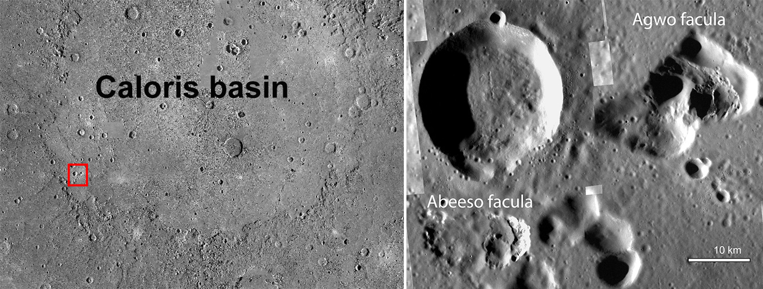
Fig.1 Left panel: Location of Agwo Facula and Abeeso Facula; right panel: Enlarged view of the area of interest showing the different derived mosaics overlapping the MDIS BDR basemap.
Data and methods:
In order to compile the maps of the two faculae we used MDIS (MESSENGER Mercury Dual Imaging System) mosaics. In particular, for Agwo Facula the main basemap is represented by derived mosaics with a spatial resolution ranging from 20 m/pixel to 28 m/pixel and with different illumination conditions. Additionally, a BDR (Basemap reduced Data Record) MDIS mosaic, with a resolution of 166 m/pixel, was considered. MDIS Wide Angle Camera (WAC) color maps, based on the reflectance at 750 nm and the visible spectral slope between 480 and 830 nm, respectively, were also used as part of the analysis. These latter maps helped determine the areal extent of the pyroclastic deposits. Finally, a Digital Terrain Model (DTM) of the region, derived from MDIS images using the technique of stereophotoclinometry (SPC) with a spatial resolution of 20 m/pixel, helped us to better characterize the facula’s topography.
For Abeeso Facula the main basemaps were MDIS derived mosaics with a spatial resolution ranging from 25 to 56 m/pixel and with different illumination conditions. Also for this area, the BDR MDIS mosaic (166 m/pixel) and MDIS WAC color maps were used as ancillary basemaps.
Results:
The geomorphological maps highlight that both Agwo Facula and Abeeso Facula experienced several explosive episodes. In particular for Agwo, through the cross-cutting relationship observed among the pits, we recognized at least eight eruptive events. The terrain within the pits shows different surface texture and albedo that allowed the distinction of several geological units: from the older and smoother surfaces to the younger and rougher textured surfaces.
On the other hand, Abeeso Facula experienced at least four different explosive episodes: the western pit is the largest and oldest one, with a smoother surface texture, whereas the eastern pit is the smallest of the cluster showing a crisper morphology, that suggests a younger age.
Moreover, differently from Agwo, Abeeso shows several hollows, located in the eastern and north-western section of the perimeter of the depression.
Conclusion:
The morphological and spectral characteristics of pits suggest that both Agwo Facula and Abeeso Facula are the result of multiple eruptions, which likely occurred at different times. However, apart from their similarities, Abeeso shows hollow features not observed on Agwo. This, despite their proximity, suggests a different composition of the substrate hosting the faculae.
References:
Kerber, L., Head, J.W., Solomon, S.C., Murchie, S.L., Blewett, D.T., Wilson, L., 2009. Earth Planet. Sci. Lett. 285, 263–271.
Goudge T.A., Head J.W., Kerber L., Blewett D.T., Denevi B.W., Domingue D.L., Gillis-Davis J.J., Gwinner K., Helbert J., Holsclaw G.M., Izenberg N.R., 2014. J. Geophys. Res., 119(3), pp. 635-658.
Thomas R.J., Rothery D.A., Conway S.J., Anand M., 2014. J. Geophys. Res., 119(10), pp. 2239-2254.
Acknowledgment
This research was supported by the International Space Science Institute (ISSI) in Bern, through ISSI International Team project #552 (Wide-ranging characterization of explosive volcanism on Mercury: origin, properties, and modifications of pyroclastic deposits). Contributions by D. Domingue and J. Weirich were also supported by NASA’s Solar System Working’s grant 80NSSC21K0165. We gratefully acknowledge funding from the Italian Space Agency (ASI) under ASI-INAF agreement 2024-18-HH.0.
How to cite: Giacomini, L., Galiano, A., Galluzzi, V., Munaretto, G., Rothery, D. A., Domingue, D., Weirich, J., Jozwiak, L. M., D'Amore, M., and Carli, C.: High resolution geomorphological analysis of Agwo Facula and Abeeso Facula (Mercury), EPSC-DPS Joint Meeting 2025, Helsinki, Finland, 7–12 Sep 2025, EPSC-DPS2025-1388, https://doi.org/10.5194/epsc-dps2025-1388, 2025.