
 1,1,2,3,2
- 1IRAP, CNRS, Université de Toulouse, Toulouse, France
- 2LATMOS/IPSL ,CNRS, Sorbonne Université, Paris, France
- 3LESIA , CNRS Sorbonne Université and Université Paris Diderot, Paris, France
Introduction : Knowing the surface albedo of a celestial body is crucial not only for understanding its composition, but also as a key input for radiative transfer models and retrieval algorithms used to derive atmospheric parameters such as aerosol optical depth. Within the MIRS (MMX InfraRed Spectrometer, 0.9–3.6 µm) team, we are specifically investigating the use of surface albedo maps to support upcoming observations of the Martian atmosphere by this near-infrared imaging spectrometer [1]. MIRS is one of the scientific instruments aboard the JAXA Martian Moons eXploration (MMX) mission [2], scheduled for launch in 2026. While the primary goal of MMX is to explore the Martian moons Phobos and Deimos and return samples to Earth by 2031, the mission also includes a significant atmospheric science component. MIRS will contribute to this by performing high-temporal resolution observations of dust storms, ice clouds, and water vapor, thereby improving our understanding of dust and water transport processes in the Martian atmosphere [1]. In preparation for the mission, it is essential to simulate MIRS observations. We are developing a Martian aerosol retrieval algorithms by building a look-up table of Mars atmosphere spectra simulated using a radiative transfer code with different parameters from which we will be able to compare MIRS observations and deducing aerosol properties such as optical depths (see details in [3]). Building this spectra database requires a global albedo map of the Martian surface in the MIRS spectral range (0.9–3.6 µm). One available dataset is the albedo map at 1.08 µm from the OMEGA (Observatoire pour la Minéralogie, l’Eau, les Glaces et l’Activité) instrument onboard the Mars Express spacecraft [4], but it contains some gaps in the data coverage (figure 1.b). The goal of this work is to develop a method to fill these gaps to generate a complete map.
Method : This method processes and merges the OMEGA albedo map (figure 1.b) (in near-IR at 1.08 µm) with data from another instrument: MARCI (Mars Color Imager) onboard the Mars Climate Orbiter [5]. Since OMEGA and MARCI have different spatial resolutions, the first step was to ensure that the two datasets could be combined effectively. First, we co-register the MARCI map (figure 1.a) onto the OMEGA grid, since they originally operate on different coordinate systems using 2D linear interpolation. Then we compute the pixel-by-pixel differences between the interpolated MARCI map and the OMEGA map, considering only valid/filled OMEGA pixels which will be used to convert MARCI UV-visible albedo values to OMEGA near-IR albedo values. To address the missing/dark pixels in the OMEGA map (Figure 1b), the script locates the nearest valid pixel for each dark pixel using the Euclidean distance [6]. It then retrieves the corresponding albedo difference from the earlier step based on the closest valid pixel. This local correction is then applied to the MARCI value at the same location, effectively estimating a new albedo value for the previously dark OMEGA pixel, resulting in a corrected OMEGA albedo map without missing data (figure 1.c). After this step, some artifacts, seen as abnormally bright pixels, remain. After filling in the dark pixels, a new difference map is calculated to compare the updated OMEGA and MARCI maps. Then, the focus shifts to correcting these abnormally bright pixels within the latitude range of 60°S to 60°N, which will be of interest for MMX observations. The map is divided into 20x20 pixels blocks, and in any block with abnormally bright pixels, those pixels are replaced using the same method described above for the dark pixels. The application of a Gaussian smoothing [6] in the final step helps to smooth the remaining artifacts by reducing abrupt changes and making the map more physically plausible (figure 1.d).
Discussion : This process allows us to produce a complete and reliable albedo map (figure 1.d), especially in high contrast albedo regions. The use of local corrections ensures that regional characteristics are preserved, and the step-wise correction of both dark and bright artifacts enhances the scientific quality of the dataset. However, it’s important to acknowledge that this method involves some assumptions, especially where no OMEGA data existed, and while the corrected values are likely reasonable, they do not come from direct measurements.
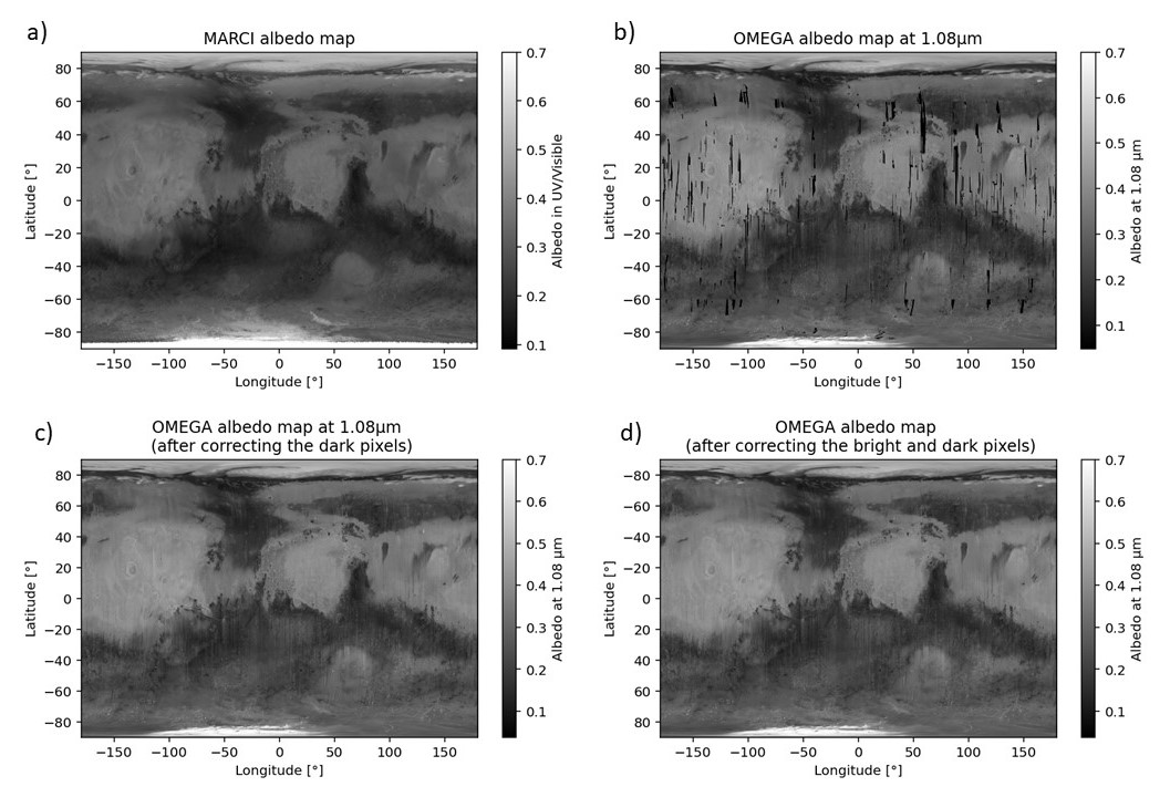
Figure 1. a) The MARCI albedo map in UV/Visible. b) The OMEGA albedo map at 1.08 µm. c) The OMEGA albedo map after filling all the dark pixels with the MARCI map. d) The final OMEGA albedo map after correcting both dark pixels and white pixels (artifacts), and smoothed with a Gaussian filter.
Conclusion : In summary, this method completes and corrects the OMEGA near-IR albedo map using MARCI UV-visible albedo map, to generate a reference OMEGA surface albedo map of Mars at 1.08 µm. The final output is a high-coverage albedo dataset, which will be useful for accurate atmospheric simulations and spectral matching during the MMX mission. This dataset may further benefit diverse planetary science studies, such as investigations of Martian surface composition. It could also support future mission planning by providing improved surface characterization in regions of interest.
Acknowledgments :
We thank M. Wolff who provided us the MARCI albedo map which came from a personal communication with S. W. Lee. We thank the MMX JAXA teams for their efforts and CNES for the financial support and collaboration to build the MIRS instrument.
References :
[1] Barucci M. A. et al. (2021) Earth, Plan. and Space, 73, 211.
[2] Kuramoto K. et al. (2022) Earth, Plan. and Space, 74, 12.
[3] Leseigneur Y. et al. (2025) EPSC-DPS2025, abstract
[4] Ody A. et al. (2012) Journal of Geophysical Research, Vol. 117.
[5] Genda H. et al. (2024) Earth, Plan. and Space, 76, 8.
[6] Virtanen P. et al. (2020) Nat. Methods, 17, 261–272.
How to cite: Le Bail, G., Lasue, J., Stcherbinine, A., Leseigneur, Y., Bertrand, T., and Gautier, T.: A new reference surface albedo map of Mars : An improved OMEGA/Mars Express albedo map at 1.08 µm, EPSC-DPS Joint Meeting 2025, Helsinki, Finland, 7–12 Sep 2025, EPSC-DPS2025-1459, https://doi.org/10.5194/epsc-dps2025-1459, 2025.