
 1,1,1,1,
- 1INAF - O.A. di Padova, Padova, Italy (adriano.tullo@inaf.it)
- 2Physikalisches Institut, University of Bern, Switzerland
Introduction
The Colour and Stereo Surface Imaging System (CaSSIS) is an advanced stereo camera developed for the ExoMars Trace Gas Orbiter mission, which has been orbiting Mars since April 2018. The CaSSIS camera can produce detailed 3D maps and capture images in four distinct color bands, providing essential data for analyzing the Martian surface and its composition [1].
An innovative telescope rotation system creates a convergence angle of approximately 22° between the images of the stereo pairs, making CaSSIS's stereo configuration possible. Operating from a circular orbit approximately 400 km above the Martian surface, CaSSIS's average ground resolution is 4.5 m per pixel, resulting in digital terrain models (DTMs) with a resolution of about 13.5 m per pixel [2].
CaSSIS has captured over 50,000 images, covering more than 8% of Mars' surface, including over 2,250 stereo-pairs. The planning of CaSSIS observations, which is guided by requests from the scientific community and the team, has focused on acquiring multiple images in areas of particular scientific interest. This has recently allowed for the acquisition of partially overlapping stereo pairs, enabling a more in-depth and comprehensive analysis of these regions.
The work outlines the new methods for creating CaSSIS mosaics of DTMs and orthophoto and their application in various areas of Mars.
Methods
The 3DPD software, developed by the INAF OAPd team [2,3], serves as the foundation for generating Digital Terrain Models (DTMs) and orthorectified images. It is also the official tool for creating CaSSIS DTMs. Since the establishment of the framework, the software has been continuously updated to enhance the performance and quality of stereo data product generation. As a result, over 450 DTMs and orthoimages have been produced and are available in the OAPD-hosted repository (https://cassis.oapd.inaf.it/archive/) and soon in the ASI Space Science Data Center repository (SSDC).
The developed pipeline enables the generation of stereo products from radiometrically calibrated CaSSIS frames by following several processing steps. Recent pre-processing improvements include a Bundle Block Adjustment phase and geometric corrections necessary for mosaicking the framelets, which help resolve misalignments that could otherwise lead to step artifacts and projection errors. The stereogrammetric processing of 3DPD, detailed by [3], is based on a two-step approach: a preliminary rough, feature-based step followed by an advanced multiscale refinement (dense-matching) step. According to [2], this process achieves a vertical accuracy of up to 8 meters, while the best horizontal accuracy is estimated at up to 13.5 meters per pixel, corresponding to CaSSIS DTM GSD (Ground Sample Distance) (3 pixel on ground). The resulting point cloud (PC), which has a heterogeneous density due to perspective viewing, is then interpolated onto a regular grid of height values within a reference coordinate system. To enhance geographical projection and absolute elevation, the point cloud is co-registered with the global MOLA-HRSC DTM [4]. This improves the accuracy to a standard deviation generally below 50 meters when compared to MOLA, effectively correcting any residual tilting. The point cloud is then interpolated, and the two original panchromatic images are orthorectified. The co-registration with MOLA simplifies the mosaicking of adjacent DTMs, as their georeferencing often requires minimal or no mutual corrections. These can typically be addressed through simple horizontal and vertical rigid translations. The seamless mosaicking process is based on the "feathering" approach, in which the overlapping areas are averaged using a weighted average that considers the inverse of the distance from the image edges and, in this implementation, from null pixels.
Region of interests
The number of areas potentially interested by multiple contiguous stereo pairs of CaSSIS is constantly being updated. Six areas have been selected for the initial assessment of the potential of CaSSIS DTM mosaics. Two of these are of particular interest for landing site studies: the north-western area of the Jezero crater (Fig. X), the location of NASA Mars 2020 surface mission [5], and Oxia Planum in Arabia Terra, chosen as the landing site for the second ESA ExoMars mission [6], currently postponed to 2028. The areas are currently interested by 14 and 13 contiguous DTMs, respectively.
The other mosaic areas include various geological contexts in different regions of Mars: southern Isidis Planitia, well-preserved craters in Utopia and Daedalia Planitiae, and peri-glacial features in the Northern Plains.
In addition to being applied in targeted geological studies, the preliminary mosaics will be evaluated globally using lower-resolution data (HRSC and MOLA) and locally using high-resolution HiRISE DTMs to verify vertical accuracy and georeferencing precision.
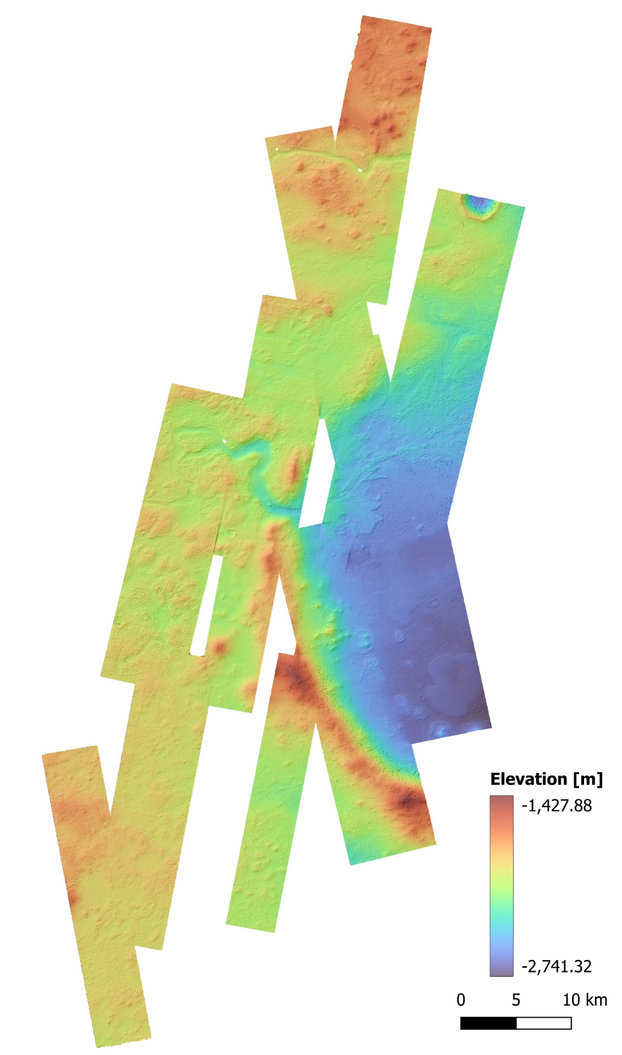
Fig, 1 Mosaic of CaSSIS DTMs at 13.5 m/px of the northwestern part of Jezero Crater. The data is derived from the composition of 14 different DTMs. The display shows the elevation in transparency on a hillshade map.
Acknowledgement
This work has been developed under the ASI-INAF agreement n. 2024-40-HH.0
References
[1] Thomas, N. et al., 2017. Space Sci. Rev., 212, 1897–1944. https://doi.org/10.1007/s11214-017-0421-1
[2] Re, C. et al., 2022. Planet. Space Sci., 219, 105515. https://doi.org/10.1016/j.pss.2022.105515
[3] Simioni, E. et al., 2021. Planet. Space Sci., 198, 105165. https://doi.org/10.1016/j.pss.2021.105165
[4] Fergason, R.L. et al., 2018. USGS Astrogeology PDS Annex.
[5] Williford, K.H. et al., 2018. In: Grotzinger, J.-P. & Webster, C.R. (Eds.), From Habitability to Life on Mars, Elsevier, pp. 275–308.
[6] Quantin-Nataf, C. et al., 2021. Astrobiology, 21(3), 345–366. https://doi.org/10.1089/ast.2020.2244
How to cite: Tullo, A., Re, C., Bertoli, S., Simioni, E., La Grassa, R., Cremonese, G., and Thomas, N.: Controlled DTM and orthoimages mosaics from ExoMars TGO CaSSIS stereo-pairs, EPSC-DPS Joint Meeting 2025, Helsinki, Finland, 7–12 Sep 2025, EPSC-DPS2025-1469, https://doi.org/10.5194/epsc-dps2025-1469, 2025.