
 1,1,2,5,9,
- 1Imperial College London, Earth Science and Engineering, London, United Kingdom of Great Britain – England, Scotland, Wales (robert.barnes@imperial.ac.uk)
- 2Joanneum Research, Graz, Austria.
- 3JPL-Caltech, Los Angeles, California, USA.
- 4Purdue University, West Lafayette, Indiana, USA.
- 5University of Hawaiʻi at Manoa, Hawai'i, USA.
- 6University of Lyon 1, Lyon, France.
- 7University of Colorado, Boulder, Colorado, USA.
- 8New Mexico Museum of Natural History and Science
- 9Johnson Space Centre, Houston, Texas, USA.
- 10Arizona State University, Tempe, Arizona, USA.
The NASA rover Perseverance traversed down the western slopes of the Jezero crater rim, informally named Witch Hazel Hill, between sols 1358 to 1500+, providing an opportunity to observe and analyse a relatively pristine, though ancient, 45 km-wide Noachian impact crater. The relatively complete exposure of the bedrock in the lower slopes and its apparent structural complexity allows us to assess the structural geometry of a major unit within the Jezero crater western rim and interpret it in its regional context. We present observations of stratigraphic and structural geometry from panoramic mosaics and digital outcrop models derived from images collected by the Mastcam-Z camera system during the traverse through the stratigraphy. Observations are collated into local and area-scale cross-sections to highlight the geometrical characteristics of the key units, deformation features, and their relationships with each other.
We focus on Broom Point on the lower western slopes of the Jezero crater rim, and its relationship with the presently overlying Shallow Bay and Millbrook outcrops within Witch Hazel Hill (Fig. 1). Broom Point contains a well-exposed section of layered bedrock comprising discontinuous light and dark toned bands exposed in a ~200 m by 300 m area. The Broom Point succession covers ~ 25 m of vertical topography in the traversed region, increasing to ~65 m to the north and is situated towards the base of the crater rim. The basal contact with a darker and apparently structureless unit called Salmon Point (Fig. 1) is abrupt, forming an arcuate shape, convex to the east. The upper contact of Broom Point (Fig. 1) is marked by an upwards change from well-defined layers to more rubbly bedrock showing signs of wide scale brecciation and alteration. The upper contact does not appear to be concordant with the internal layer geometries at Broom Point, whereas the lower contact with Salmon Point does appear to be parallel to the internal layer geometries (Fig. 1).
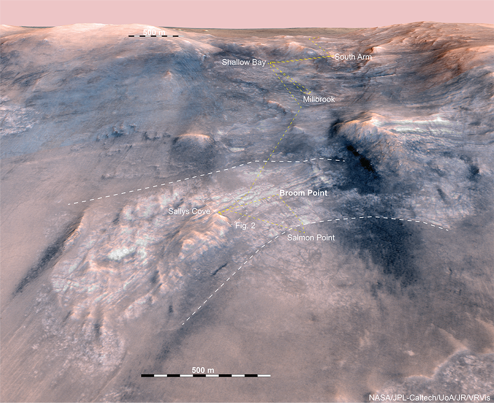
Figure 1. 3D view of Witch Hazel Hill on the western side of the Jezero crater rim. The white dashed line shows the locations of the upper and lower contacts of Broom Point. The dashed yellow line delineates the rover traverse.
Outcrop at Broom Point is heavily weathered, but four main lithofacies are observed within the alternating light and dark toned units (Fig. 2); (1) an angular matrix/groundmass supported breccia; (2) light-toned, laminated, fine, particulate lithology; (3) a light-toned, structureless, fine, particulate lithology; and (4) spherule-bearing (1-5 mm in diameter) layered rocks. These facies occur in multiple fining-up sequences which may represent emplacement from multiple volcanic eruptions or impact events.
Topographic relief and exposure of contacts between the light-toned laminated and breccia facies at Sallys Cove enabled us to constrain layer dip in that location to <60° to the northeast (Fig. 2), into the slope of the hillside. Fine, parallel laminated layers of rounded spherules further east within the outcrop dip ~45° to the east and northeast, largely parallel to the overall layer contacts. The change in dip direction observed between Sallys Cove to Broom Point indicates that the layering outlines a fold structure.
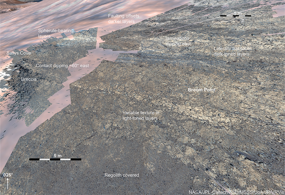
Figure 2. Digital outcrop model of the stratigraphic sequence exposed around Sallys Cove at Broom Point.
A series of ENE-WSW striking, parallel, relatively regularly spaced fractures are observed to cut the banded unit at Witch Hazel Hill. In some locations <5 m of apparent sinistral and dextral offset is observed, interpreted as a result of faulting of dipping layers along dipping fault surfaces. The fault geometries are consistent with extensional deformation. The faults are not present above the contact with Millbrook and do not appear to have deformed the upper and lower bounding surfaces of the banded unit. They are therefore interpreted to have formed before or during the deformation responsible for the dipping layers at Broom Point.
The overall geometry defined by the layering at Broom Point is a broad, east plunging anticline, of which the Perseverance Science team have traversed the crestal region. Stratification is difficult to define in rim units overlying Witch Hazel Hill, such as Millbrook and South Arm (Fig. 1), where apparent layering or foliation predominantly dips to the west. We constrain the location of this dip change to occur at the upper contact of the light-toned banded unit at Broom Point, an observation consistent with layer truncations apparently visible in orbital data. The contact is poorly preserved in outcrop so it is not possible to determine whether it is the expression of faulting, an erosional unconformity, or whether it defines the limit of in-place brecciation and foliation within the outer part of the crater rim. It appears to mark a clear change in overall structure nonetheless.
Previous observations and numerical modelling of Jezero-scale impacts show that the extent of layer rotation, faulting and lithologies observed at Broom Point are difficult to explain as having occurred solely as a result of the Jezero impact itself. It is therefore interpreted that Broom Point at Witch Hazel Hill records repeated volcanic or impact and deformation events which pre-date the Jezero impact and may have formed and deformed during the regional Isidis basin forming or other major pre-Jezero event.
How to cite: Barnes, R., Jones, A., Gupta, S., Paar, G., Stack, K., Gwizd, S., Klidaras, A., Deahn, M., Ravanis, E., Quantin-Nataf, C., Mayhew, L., Horgan, B., Crumpler, L., Simon, J. I., Rice, J., Bell, J., and Maki, J.: Pre-impact stratigraphy exposed in the western Jezero crater rim, EPSC-DPS Joint Meeting 2025, Helsinki, Finland, 7–12 Sep 2025, EPSC-DPS2025-1618, https://doi.org/10.5194/epsc-dps2025-1618, 2025.