
 1,2,3,
- 1University of Naples Federico II, Department of Earth Sciences, Environment and Resources (DISTAR), Naples Italy (mariarca.daniello@unina.it)
- 2National Institute of Astrophysics, Astronomical Observatory of Capodimonte (INAF-OACN), Naples, Italy
- 3University of Naples Federico II, Department of Electrical Engineering and Information Technology (DIETI), Naples, Italy
- 4Stazione Zoologica Anton Dohrn, Naples, Italy
Introduction
Fluvial networks provide key insights into surface processes, underlying lithology, and the tectonic and climatic history of planetary bodies. On Earth, these drainage systems have been studied extensively, but classification still relies heavily on visual interpretation. Such manual methods are not scalable, especially when applied to large datasets or remote planetary terrains where direct observation is limited. This study presents a fully automated, unsupervised machine learning framework designed to classify fluvial patterns objectively, initially tested on terrestrial rivers but developed with a clear orientation toward planetary applications.
Methods
The classification pipeline begins with HydroRIVERS v1.0, a global hydrographic dataset, from which river segments are extracted. For each segment, a suite of morphometric descriptors is calculated, encompassing parameters related to geometry, orientation, curvature, and network topology. These features are used as inputs for unsupervised clustering. Three clustering techniques were evaluated: K-Means, Gaussian Mixture Models (GMM), and CLARANS. Among them, K-Means consistently delivered the highest internal validation scores across silhouette, Davies-Bouldin, and Dunn indices. CLARANS, while computationally more intensive, offered greater interpretability by selecting real river segments as cluster centers, which is especially valuable in a geomorphological context. Classification at the river-system level was then achieved by exploring multiple strategies, including majority voting among segments, and aggregation of morphometric features by their mean or median; they all produced reliable and coherent drainage typologies.
Results
The optimal solution identified six distinct morphometric clusters. These clusters were subsequently interpreted and labeled based on canonical fluvial patterns, such as dendritic, sub-dendritic, radial, trellis, and rectangular. This interpretation followed geomorphological typologies standardized by Donadio et al. (2021) (Figure 1), enabling the translation of purely numerical groupings into geological meaning.
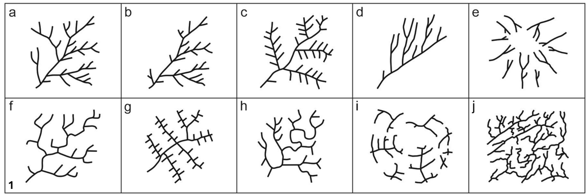
Figure 1. Different classes of drainage patterns following the scheme proposed by Donadio et al. 2021: a) dendritic; b) sub-dendritic; c) pinnate; d) parallel; e) radial; f) rectangular; g) trellis; h) angular; i) annular; j) contorted.
Validation against a reference dataset containing thousands of manually classified segments showed strong agreement. The K-Means algorithm achieved high consistency with expert labels, while CLARANS proved useful in highlighting key reference cases. To visualize the effectiveness of clustering, a principal component analysis (PCA) was performed, projecting the high-dimensional feature space into three dimensions (Figure 2).
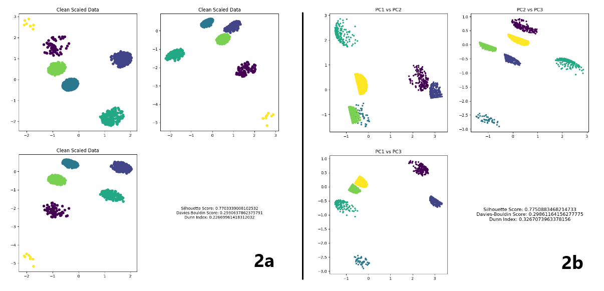
Figure 2. Images of the resulting distribution, where the six clusters form distinct, compact groupings: 2a shows the clustering results with k-means algorithm; 2b shows the clustering results with CLARANS algorithm.
Planetary Application and Discussion
The versatility of the proposed framework makes it well suited for planetary science. Many bodies in the Solar System, such as Mars and Titan, show evidence of ancient or current fluvial activity. These features, visible in high-resolution orbital imagery, share morphometric properties with terrestrial rivers. The automated and objective nature of our method is ideal for application to planetary surfaces, where field validation is not possible and manual classification is impractical. On Mars, dendritic valley networks such as Warrego Valles (Figure 3) could be objectively identified and differentiated from structurally controlled systems like those near Valles Marineris. On Titan, channel networks via Cassini RADAR data present complex patterns possibly influenced by tectonics or cryovolcanism. The ability to distinguish between morphometric types without supervision may support hypotheses on climate evolution and crustal processes in these environments.
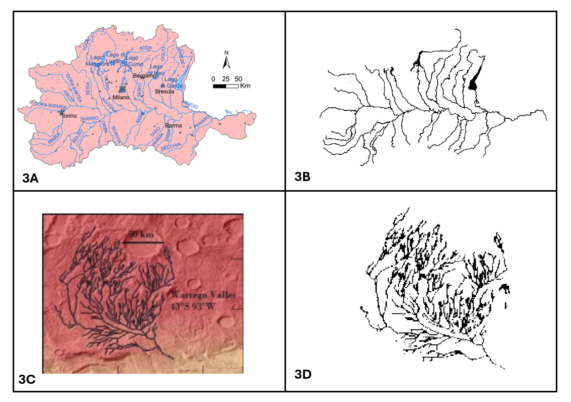
Figure 3. A visual comparison between a dendritic river system on Earth and a Martian network: 3A shows the original image of Po River (Italy) before pre-processing; 3B shows the manually extracted image of Po River. 3B shows the original image of Warrego Valles (Mars) before pre-processing; 3B shows the manually extracted image of Warrego Valles (Mars).
In the future, this approach may also be extended to Venus, where missions like ESA’s EnVision could reveal previously hidden fluvial features through synthetic aperture radar. Additionally, expanding the feature set to include elevation data and terrain roughness could further enhance classification capability and geological interpretation.
Conclusions
This study introduces a robust, unsupervised framework for the classification of fluvial networks that moves beyond the limitations of subjective interpretation. While trained and tested on terrestrial data, the method is explicitly designed with planetary applications in mind. It demonstrates strong potential for analyzing fluvial systems on Mars, Titan, and other planetary bodies, offering new perspectives on landscape evolution and hydrologic history. Future work will focus on applying the pipeline to specific planetary case studies, enhancing feature sets, and integrating data from multiple remote sensing platforms.
How to cite: D'Aniello, M., Velotti, C., Esposito Mocerino, G., and Donadio, C.: A Novel Machine Learning Approach for Objective Fluvial Network Classification: Earth & Beyond, EPSC-DPS Joint Meeting 2025, Helsinki, Finland, 7–12 Sep 2025, EPSC-DPS2025-1703, https://doi.org/10.5194/epsc-dps2025-1703, 2025.