
 1,1,1
1,1,1- 1The Open University, School of Physical Sciences, United Kingdom
- 2The Open University, School of Environment, Earth and Ecosystem Sciences, United Kingdom
Introduction
Noachis Terra, in Mars’ southern highlands, is a region which is poorly dissected by erosional fluvial landforms[1,2] but which warm/wet climate models of the early Martian climate predict should have experienced high rates of precipitation[3]. A recent study in Arabia Terra[4], another poorly dissected region of the highlands, found a network of distributed sinuous ridges. These were interpreted as fluvial sinuous ridges (FSRs), topographically inverted fluvial channel belts that are at least as old as the Noachian-Hesperian transition and interpreted to be evidence for ancient river systems with high depositional rates. Noachis is similarly aged, but has a distinctly different geological history[5], so finding FSRs here would provide evidence both for widespread ancient rivers in another part of Mars, and also suggest this style of fluvial activity was common across Mars’ highlands at this time.
Methods
We used ArcGIS Pro software to conduct a survey of a > ten million km2 study area (-35°E, -12°N; 45°E, -55°N). We used the Context Camera (CTX[6]) online global mosaic (5-6 m/pixel[7]), supplementing this with High Resolution Science Experiment (HiRISE; 25-50 cm/pixel[8]) data. We digitized FSRs at a scale of 1:50,000 and measured, calculated, and classified key features relating to each ridge segment, assigning each ridge to one of four morphotypes. We categorised ridges as either ‘certain’ or ‘confident’ based on exposure and image quality; if ridges did not meet these criteria, they were excluded.
Results/Discussion
Morphology:
‘Certain’ ridges have a combined length of more than 8,000 km. This increases to 15,000 km if including the ‘confident’ class. Here we discuss only the ridges classified as certain.
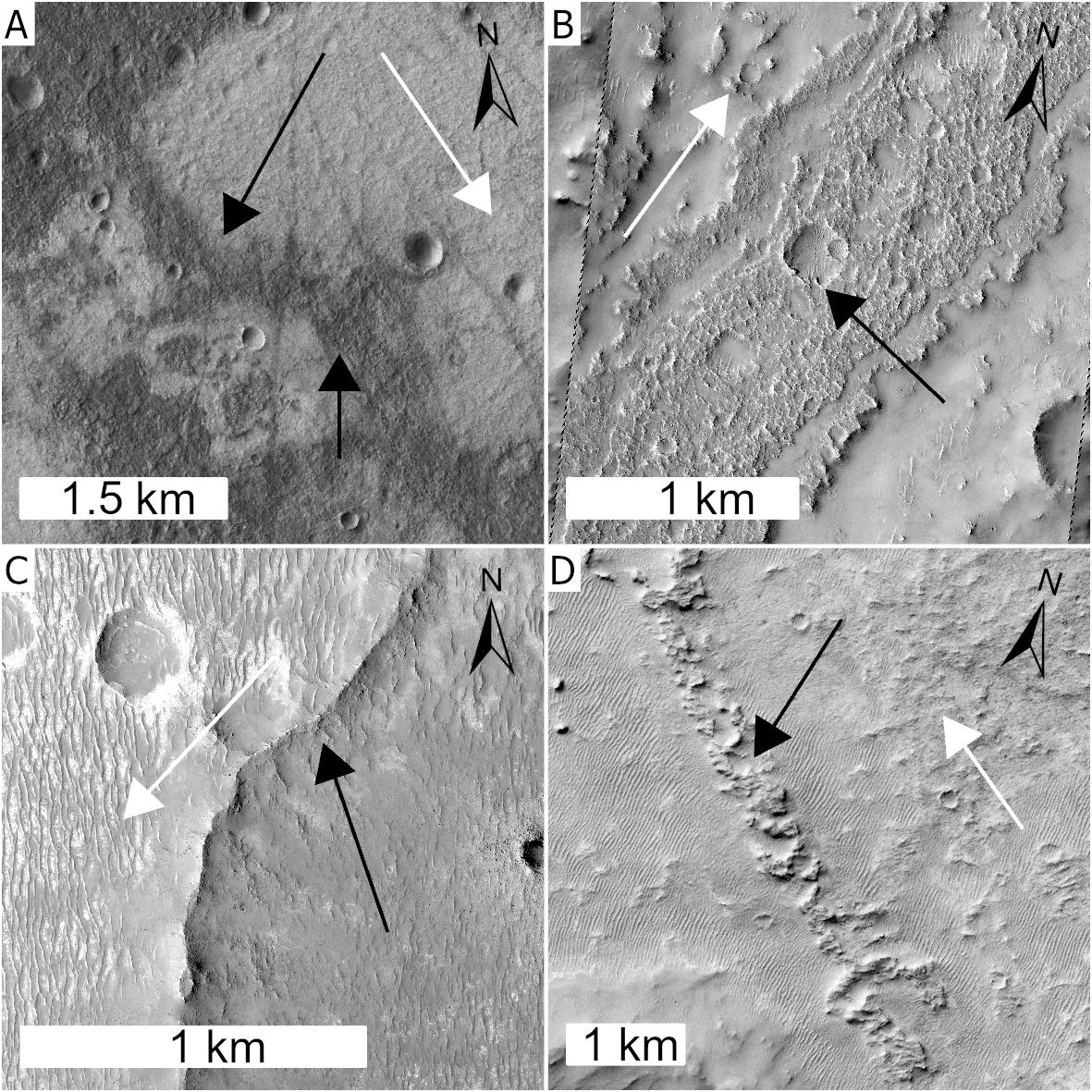
Figure 1: FSR types. Black arrows denote FSRs, white arrows denote downslope topographic trends. A) Type A: rare. B) Type B: most common, 84% of the total length for ‘Certain’ FSRs. C) Type C: narrow, pointed. D) Type D: heavily degraded chains of mounds.
Individual FSR segments are a few kilometres to tens of kilometres long. All four types are sinuous to sub-sinuous: the 30 longest segments (>20 km each) have an average sinuosity of 1.2. The ridges all appear to conform to local topographic trends, exhibit various degrees of preservation, range in width from <100 m to >3 km and exhibit 2-21 m of vertical relief. The shortest segment digitised is 200 m long and the longest is more than 78 km. Visible internal layering or structure is rare and offers little additional information. FSRs commonly record curving plan-view shapes that we interpret as meanders, branching, anastomosing, and smaller ridges connecting at oblique angles to a central wider ridge, which we interpret as tributaries joining a main channel. Ridges with branches may record avulsions or anabranching, or might represent different generations of fluvial activity stacked vertically[9].
Distribution:
The FSRs are widely distributed across Noachis Terra. They are predominantly found in local depressions, and more than 91% (in length) occur in the intercrater plains. Many distinct FSR segments can reasonably be linked to one another, suggesting that river systems many tens or even hundreds of kilometres long were present. However, there are other examples of isolated FSRs or multiple FSRs that do not align with one another, demonstrating that either shorter systems were common or that erosion has removed the evidence for longer rivers. There is little variation in distribution for type B, C, and D, though there is a significant concentration of all FSRs in and west of Greeley Crater (4°E, -37°N); this is also where most type A FSRs occur. We find few FSRs at latitudes higher than 47°S. This indicates a true absence of ridges here, but also shows that we were more conservative in identification due to icy mantling and poorer data quality this far south. The broad distribution of FSRs suggests that the water source must also have been widely distributed (e.g. precipitation). The most likely explanation for the distribution of FSRs is a protracted period (or periods) during which the regional climate was able to sustain precipitation and allow stable surface water long enough to form river systems.
Almost a quarter of FSRs can be found within, or connected to, valleys. Many of these FSRs are in the lower reaches of individual fluvial systems but in other cases FSRs transition to and from valleys. The FSRs occur as narrow, sometimes isolated sections, and are not amenable to accurate age determination using crater counting. Nevertheless, the FSRs are all on Noachian Basement units[10]. The oldest crater they are present in is Dollfus (-4.2°E, -21.4°N; ~4.08-4.013 Ga[11]), and the youngest is Bakhuysen (15.7°E, -22.7°N; ~ 3.49-3.73 Ga[11]). The maximum age of the FSRs is likely to be Noachian or Early Hesperian.
Conclusion
More than 15,000 km of FSRs occur across Noachis Terra, a region of Mars’ southern highlands that is poorly dissected by valleys. These record evidence of sustained fluvial processes, and deposition of fluvial sediment, in a region that was previously thought to lack them. They are likely to have formed during the late Noachian or Early Hesperian, suggesting an at least transiently warm and wet early Mars. These observations provide an important input into future climate models for this period, especially into those that use a lack of valleys in this region to argue against a warm, wet climate[3]. We suggest that having found FSRs in two geologically and geographically diverse, but similarly-aged highland regions on Mars[4], FSRs are likely to be present throughout many Noachian/Hesperian highland regions. Similar survey projects examining CTX data in other regions will test this hypothesis.
References
1 Alemanno et al., Earth and Space Science (2018)
2 Hynek et al., JGR: Planets (2010)
3 Wordsworth et al., JGR: Planets (2015)
4 Davis et al., Geology (2016)
5 Fassett and Head, JGR: Planets (2007)
6 Malin et al., JGR: Planets (2007)
7 Dickson et al., Earth and Space Science (2024)
8 McEwen et al., JGR: Planets (2007)
9 Hayden et al., Icarus (2019)
10 Tanaka et al., USGS (2014)
11 Robbins et al., Icarus (2013)
How to cite: Losekoot, A., Balme, M. R., Coe, A. L., and Fawdon, P.: The Fluvial History of Noachis Terra, Mars, EPSC-DPS Joint Meeting 2025, Helsinki, Finland, 7–12 Sep 2025, EPSC-DPS2025-1751, https://doi.org/10.5194/epsc-dps2025-1751, 2025.