
 1,1,
1,1,- 1National Institute for Astrophysics (INAF), Bologna, Italy
- 2Institute for Advanced Engineering and Space Sciences, Australia.
Introduction: Bright basal reflections detected by MARSIS (Mas Advanced Radar for Subsurface and Ionosphere Sounding) over four areas, 10s of km across in the Ultima Scopuli region of the Martian South Polar Layered Deposits (SPLD), have been interpreted as evidence of large bodies of liquid briny water (Orosei et al., 2018; Lauro et al., 2021). Little is known, however, of the basement morphology, which is critical to constrain the processes of pooling of the brines. Previous work has focused on the geological interpretation of features surrounding the SPLD (Landis and Whitten, 2022), the morphology and the elevation of the surface of the SPLD at Ultima Scopuli (Arnold et al., 2022; Sulcanese et al., 2023), resulting in conflicting interpretations. The morphometric characteristics and orientation of SPLD scarps can be interpreted to obtain clues on the morphology of the substratum (Byrne and Ivanov, 2004).We present the preliminary results of our investigation of scarps in Planum Australe (Fig. 1) from Context Camera (CTX) imagery, expanding the study area beyond that encompassing the bright basal reflections. Our aim is to compare the features above and around Ultima Scopuli, and to obtain significant statistics on scarps that could aid interpretation. We map the scarps, measure their length and depths, and determine their structural orientation. We compare our results to those obtained in an earlier study of the scarps of the region (Grima et al., 2011) and interpret our results.
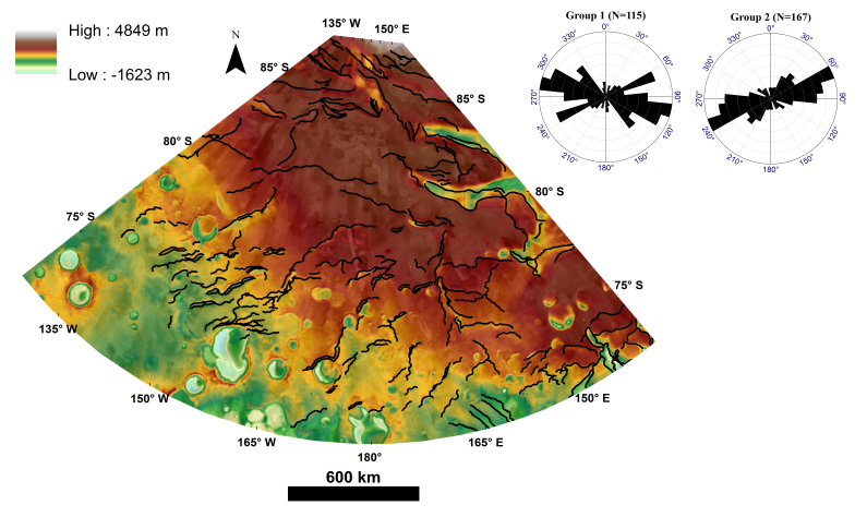
Figure 1. Structural map for the study area in Planum Australe at 1:6,000,000output scale. The rose diagram (top right) shows the trends of the LAPS over the polar stereographic map.
Description: Large asymmetric scarps (Grima et al.’s, 2011, “LAPS”) are characterized by straight sloping face and convex slope. The straight faces are arcuate and cut through the strata of the SPLD. Opposite the straight scarp, a gently sloping convex face is formed by inward dipping strata. The basic morphology of the LAPS indicates faulting of brittlely behaving ice. Their arcuate trace, however, may be related to the presence of impact craters, or reflect wind erosion, as also proposed in previous studies (Grima et al., 2011). Both interpretations are possible, but further work is necessary to clarify the interplay between both processes, and to understand whether any other geological scenario is possible. When observed at larger scale (Fig. 2), the scarps present complex features, possibly produced by sliding of ice along the scarps, which attests to the occurrence of secondary processes overprinting on the primary structural elements. Thus, the scarps represent a record of geologic and climatic processes, acting at different time scales.
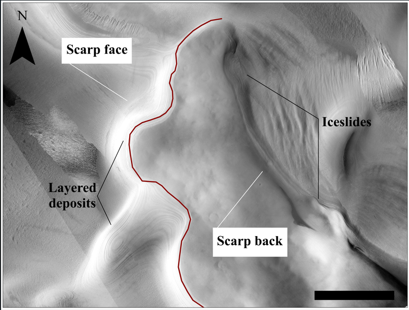
Figure.2. CTX monochrome images show layered deposits and mass waste on the scarp sides.
Spatial distribution and Morphometry: We mapped N=282 scarps, thus increasing the data base of earlier work (Grima et al., 2011). Figure 1 shows the context area, the spatial distribution and orientation of the scarps. The lengths of the scarp traces (Fig. 3) identify two distinct groups: the scarps present in areas of positive Mars Orbiter Laser Altimeter (MOLA) elevation (Group 1, N=115) have lengths ranging between 27 km and 635 km; those at negative MOLA elevation (Group 2, N=167) have lengths between 10 km and 274 km. The horizontal distance between two scarps is correspondingly different. Preliminary measurements on the first group of scarps give values ranging from several km to a maximum measured distance of 270 km, while for the second group we measured distances from a few meters to tens of km. This suggests that the groups identified on the grounds of elevation, are probably too broad from a morphometric perspective, and subclassification is warranted. This has a structural significance and may imply a difference in the shape or thickness of the underlying materials or different compositions. The log-log plot of the cumulative frequency of the scarp lengths (Fig. 4) shows a linear section fitting a power law describing the structural element of the scarps.

Figure.3. Frequency vs. length limits of the 1st (a) and 2nd (b) group of scarps.

Figure 4. Logarithmic representation of the cumulative frequency of scarps (282) versus the length of the scarps track (L).
We measured the orientations of the scarps at regional scale and elaborated them on rose diagrams (Fig. 1). The diagram supports the classification of the scarps in two principal groups with different dominant azimuths: 100 (Group 1) and 65 (Group 2). We define the maximum depth of the trough in between the steep and convex scarps as the vertical distance between the hanging and the footwall of the scarp, measured from MOLA topographic profiles across the structures. A clear distinction between the longer (at higher elevation: depth of trough up to 1.6 km) and shorter (at lower elevations) structures, typically only a few 10 meters deep. The scarp slopes range from ~5°-30°, attesting to the action of secondary processes, such as ice-sliding along the scarp and therefore possible fluidification (after insulation) and solidification in situ of the ice, or mass wasting.
Discussion and Conclusion:
Here we showed that structural elements were overprinted by secondary morphologies typical of geological and climatic processes, which require further investigation. We need to separate the secondary elements from the primary structures to unravel the underlying structure of the strata and of the basement. Our work thus far points to possible differences between the thickness and number of strata in zones of higher and lower elevation, which need to be further investigation. Ultimately, this information is relevant to better constrain the basement morphology in the region of the bright basal reflections.
Acknowledgments: This research was supported by the Italian Government and the Next Generation EU program, Mission 4, Component 1, through project "Assessing the oRigin and stability of mar-tian sub-glacial watErS" (ARES), Unique Project Code C53D23001300006.
References:
Arnold et al. (2022) https://www.nature.com/articles/s41550-022-01782-0
Byrne and Ivanov (2004) https://doi.org/10.1029/2004JE002267
Grima et al. (2011) https://doi.org/10.1016/j.icarus.2010.12.017
Landis ME, Whitten JL (2022) https://doi.org/10.1029/2022GL098724
Lauro et al. (2021) https://doi.org/10.1038/s41550-020-1200-6
Orosei et al. (2018) https://www.science.org/doi/10.1126/science.aar7268
Sulcanese et al. (2023) https://doi.org/10.1016/j.icarus.2022.115394
How to cite: El Yazidi, M., Orosei, R., and Caprarelli, G.: High and low-relief scarps analysis in the south polar layered deposits, Mars, EPSC-DPS Joint Meeting 2025, Helsinki, Finland, 7–12 Sep 2025, EPSC-DPS2025-1954, https://doi.org/10.5194/epsc-dps2025-1954, 2025.