

- Freie Universität Berlin, Berlin, Germany
Recent advancements in processing capabilities and software interoperability have significantly improved photogeological analysis. However, the sheer volume of image datasets continues to present scientists with challenges. Effective analysis requires specialist knowledge of camera instruments, particularly for Mars exploration, where missions have continuously delivered images since the 1960s and several new missions are already in the pipeline. We present a typical workflow for Mars remote sensing imagery, emphasising the importance of combining accumulated information in the form of its spatiotemporal context (see Fig.1).
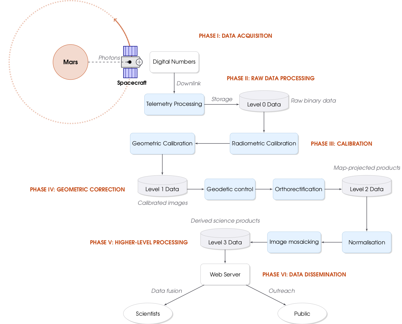
Fig. 1: Flowchart for a typical life-cycle of planetary remote sensing image data from acquisition to dissemination.
Although data fusion with other instruments and thematic maps offers new interpretative possibilities, it is difficult due to several challenges. High-resolution imagery often suffers from insufficient geodetic control, resulting in misplaced images. Although multi-instrument co-registration to well-controlled reference datasets can address this issue, it requires specialised expertise. Brightness normalisation methods have improved, but they incorporate secondary derived data that is not fully reproducible. The strong influence of illumination-induced shading, which often varies between dataset acquisitions, poses a significant challenge. Furthermore, certain applications prohibit altering the physical values of image contents.
These challenges highlight the urgent need for improved image pre-processing, including radiometric and geometric calibration. Such processing requires in-depth knowledge of the instruments, which can take years to acquire and which analysing scientists may not possess. As a key example, we address the radiometric calibration of the CTX camera. This instrument has orbited Mars since 2006 and suffered from a significant defect that caused darkening of 8% towards the edges, known as the 'smile/frown effect'. Our new in-flight calibration eliminates this effect entirely, enabling more precise albedo measurements and seamless mosaicking (see Fig. 2).
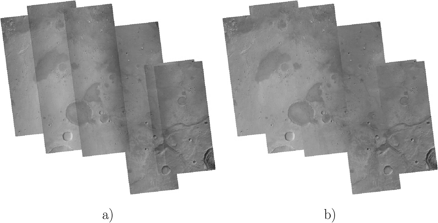
Fig. 2: Example CTX mosaic of the Oxia Planum region, ExoMars Rosalind Franklin Rover landing site. Images were chosen from Martian Year 33. (a) before, (b) after the new flat-field calibration [1].
The vast data volumes make tracking the availability and accessibility of data difficult. Proper mapping requires access to the original data, since mosaicking can destroy information that cannot be reproduced by every analyst. Scientists often have to analyse thousands of images for a single region of interest, which overwhelms standard tools. While numerous initiatives aim to process planetary image data on a large scale to make it more easily accessible to scientists, interoperability between proprietary software vendors remains inconsistent. We introduce innovative methods for managing these vast image collections, providing enhanced functionality through interactive, web-based mapping tools. These tools facilitate spatiotemporal analysis both online and within specialised research environments, such as GIS.
Our work demonstrates the practical application of these approaches through geological case studies of surface changes and spatiotemporal analyses on Mars.
[1] Walter, S. H. G., Aye, K.-M., Jaumann, R., & Postberg, F. (2024). Mars reconnaissance orbiter context camera updated in-flight calibration. Earth and Space Science, 11, e2023EA003491. https://doi.org/10.1029/2023EA003491
How to cite: Walter, S.: Life cycle of planetary images from Mars orbit - from raw data processing to high-level data dissemination, EPSC-DPS Joint Meeting 2025, Helsinki, Finland, 7–12 Sep 2025, EPSC-DPS2025-1959, https://doi.org/10.5194/epsc-dps2025-1959, 2025.