
 1,2,
1,2,- 1LPG-CNRS-UMR6112, Univ Nantes, Nantes, France (nicolas.mangold@univ-nantes.fr)
- 2GET-Toulouse, Université Toulouse, France
- *A full list of authors appears at the end of the abstract
The western fan of Jezero crater displays features interpreted as fluvial and deltaic sedimentary rocks from orbital data (1,2). Images obtained using the SuperCam Remote Micro-Imager (RMI) and the Mastcam-Z cameras provide in-situ observations of Jezero crater’s western fan in various locations along the Perseverance traverse. Using these tools, we show that fluvial topsets and deltaic foresets dominate sedimentary rocks of the western fan.
On the fan front, we observe a systematic stratigraphy (3): (I) The bottom of hillslopes displays recessive, light-toned deposits that are best explained as lacustrine deposits at the delta toe (bottomsets and toesets), part of the Shenandoah fm. (4). (II) The central part of the fan front hillslopes corresponds to dipping foreset beds typically developed over 20 to 25 m of vertical extension. They usually display sigmoidal geometry with steeply dipping (15-35°) sandstones and conglomerates. (III) Above the foresets various types of fluvial deposits (sandstones and conglomerates) are present, with frequent cross-bedding interpreted as topset beds. The transition between topsets and foresets corresponds to the transition from the river to the lake, marking the former lake level. Hence, we can deduce paleolake level from this architecture. At the fan front, these elevations vary from -2470 to -2500 m, in agreement with what has been deduced at the Kodiak butte, i.e., -2490 and -2500 m (5,6).
On the fan top, we observe the same two facies (II) and (III) observed at the front. For instance, Pinestand Mountain is a butte with uppermost elevation of -2448 m that contains thick bed sets (~14 and ~22 m) with up to ~35-40° dipping sigmoidal strata and textures typical of sandstones, which are interpreted as foresets. Such stratigraphy is also observed within the 1km-diameter Belva crater rims closer to the fan apex (elevation -2410 m), with a sequence of dipping layers interpreted as foresets up to 34 m high. In contrast, the Tenby outcrop is a flat, low-lying outcrop but its strata dip up to ~40°. The outcrop surface expression with arcuate beds corresponds to that observed across most of the delta top in plan-view, which is linked to the orbitally-defined “curvilinear” pattern. This unit was previously interpreted as fluvial, meandering bar deposits (7). However, in the case of meander belts, the vertical extent of these bed sets would correspond to the minimum channel water depth (e.g., 8). Here, with bed sets as high as 34 m at Belva or 22 m at Pinestand Mountain, such a process would require km-wide meanders rather than the ~100 m size bodies observed on the delta top. We therefore favor the interpretation that the “curvilinear” pattern mostly represents the surface expression of deltaic foresets, similar to those visible at Pinestand Mountain.
Overall, these strata enable us to delineate the evolution of the lake levels of Jezero paleolake, which stretch from the topmost location north of the Belva crater (-2410 m), Pinestand Mountain (-2448 m) to the lowermost elevations at Kodiak and Eastern Cape (-2500 m) (Figure 1). This evolution is related either to a progradation from top to bottom during forced regression (lake level fall from -2410 m to -2500 m) or a retrogradation from bottom to top (lake transgression from -2500 m to -2410 m). Yet, terrestrial examples of deltas formed by transgression show that the fluvial topsets are buried below the subsequent foreset beds. No observation here shows such a geometry. In contrast, we observe both truncation of foresets by fluvial topsets and superimposition of steep foresets on gently dipping foresets that were deposited previously. Both geometries are typical of progradation during lake level fall (forced regression). Such a scenario has implications for the chemical evolution of the lake, for instance the formation of evaporitic minerals during the drying out of the lake.
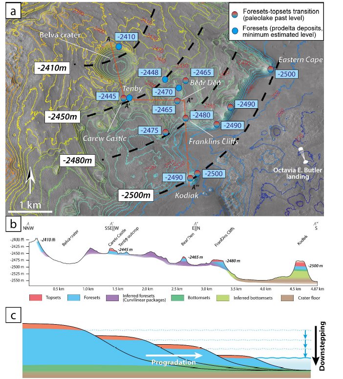
Figure 1: (a) Map of the western delta of Jezero with topographic contours in color. Elevations in blue boxes indicate the benchmarks of the paleolake level (topset-foreset transition, red-blue disks) or minimum paleolake elevation (foresets only, blue disks). The elevations in white boxes and the related black, dashed lines are extrapolations of these elevations showing a consistent downstepping from -2410 m at the fan top (Belva crater) toward -2500 m at the Eastern Cape and at Kodiak. (b) Schematic cross-section of the area highlighting the local deltaic morphologies expressed and corresponding paleo-lake levels. (c) Interpretative sketch of a deltaic downstepping sequence during a forced regression (adapted from 9).
References:
(1) Stack et al., 2020, Space Sci. Rev. 216(8), 127. (2) Goudge et al., 2018, Icarus 301, 58-75. (3) Mangold et al., 2024, JGR-Planets, 129, e2023JE008204. (4) Stack et al., (2024), 129, e2023JE008187, (5) Caravaca et al., 2024, JGR-Planets, 129, e2023JE008205. (6) Mangold, Gupta et al., 2021, Science, 374, 711-717. (7) Schon et al., 2012, Planet. Space Sci., 67, 28-45. (8) Ghinassi et al., 2016, Sedim. Geology, 334, 66-96. (9) Winsemann, J., et al., 2018, Bores, 47, 973-1002.
N. Mangold, G. Caravaca, R.M.E. Williams, S. Gupta, K.L. Siebach, K.M. Stack, R. Barnes, L.S. Crumpler, G. Dromart, L.C. Kah, L.R.W. Ives, S. Gwizd, O. Gasnault, S. Le Mouélic, O. Beyssac, J.A. Hurowitz, M.M. Tice, J.W. Rice, N. Carlot, M. Nachon, N. Randazzo, J.F. Bell III, E. Dehouck, A. Annex, J.I. Simon, A. Cousin, S. Maurice, R.C. Wiens
How to cite: Mangold, N. and Caravaca, G. and the Perseverance rover Mars 2020 Delta observation sub-team: Paleolake variations of Lake Jezero, Mars, recorded by the deltaic architecture of Jezero crater western fan, EPSC-DPS Joint Meeting 2025, Helsinki, Finland, 7–12 Sep 2025, EPSC-DPS2025-217, https://doi.org/10.5194/epsc-dps2025-217, 2025.