
 1,2,3,1,3,5,2,1,4,1,7,3
- 1University of Padua, Department of Geosciences, Padova, Italy (beatrice.baschetti@phd.unipd.it)
- 2Italian Institute for Astrophysics (INAF) - IAPS, Rome, Italy
- 3Italian Institute for Astrophysics (INAF) - OAPd, Padova, Italy
- 4Institute of Geosciences and Earth Resources - National Research Council of Italy, Padova, Italy
- 5Centro di Ateneo di Studi ed Attività Spaziali “G. Colombo” (CISAS), University of Padova, Padova, Italy
- 6Department of Physics and Astronomy, University of Padova, Padova, Italy
- 7Department of Physics and Geology, University of Perugia, Perugia, Italy
Introduction. Several lines of evidence support the idea that Mars once had surface conditions very different from today’s cold, extremely dry environment. In particular, both the planet's morphology and mineralogy indicate that water-rich -and potentially habitable- environments were widespread during its early history [e.g., 1]. This important chapter in Mars' geologic history roughly spans one billion years, comprising the Noachian (4.1–3.7 billion years ago) and Hesperian (3.7–3.0 billion years ago) periods.
During these two epochs, Mars experienced both the peak and the decline of its water activity. Indeed, each epoch’s aqueous processes have distinct mineralogical and geomorphological signatures whose succession indicates a trend toward aridity. In the Noachian, widespread valley networks [e.g., 2] and abundant clay minerals [3] point to sustained surface runoff and alteration by neutral-mildly alkaline water, suggesting a potentially “warm and wet” climate. By the Hesperian, sulfate evaporites [e.g., 3, 4] became more common, and valley network formation declined. Instead, isolated, large-scale floods from underground sources occurred, especially toward the era’s end [5]. These changes reflect reduced surface water and increasingly acidic conditions. The Noachian-Hesperian transition therefore marks an important turning point in the climatic history of the planet. Yet, its timing and characteristics are still poorly constrained.
Study object and target area. The “Equatorial Layered Deposits” (ELDs) are defined as a variety of stratified sedimentary rock outcrops found globally in the Martian equatorial belt. ELDs are characterized by easily erodible hydrated minerals (commonly sulfates) and they can exhibit cyclical light and dark toned layering (Figure 1). The region of Meridiani Planum, hosts many examples of ELDs (here also historically referred to as “etched terrains” [6]) that formed around the Noachian-Hesperian boundary and which represent a key archive of Mars’ past climate. Overall, there is an ongoing debate regarding their formation processes, which remain uncertain [6,7].
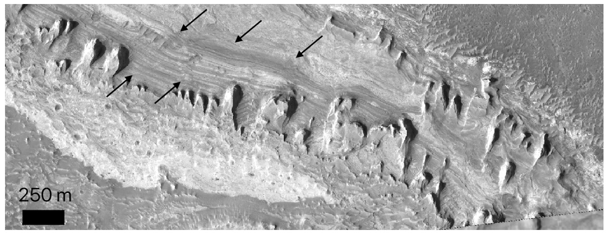
Figure 1. Equatorial Layered Deposits as seen by HiRISE (ESP_020138_1845) in Kai crater, Meridiani Planum. Arrows point at the alternating light and dark toned layers.
Scientific objectives. We conducted a detailed analysis of the mineralogy and stratigraphy of the ELDs in selected areas of Meridiani Planum in order to better understand their possible formation processes and derive insights into Mars’ past climatic conditions at the Noachian-Hesperian boundary.
Data and methods. Three relatively small (<= 20 km) craters (Kai crater and two unnamed craters, hereafter termed A and B) are selected in northern Meridiani Planum showing repetitive beddings of light and dark toned layered deposits rich in hydrous minerals. We combined the mineralogical and stratigraphic information of these targets using CRISM (Compact Reconnaissance Imaging Spectrometer for Mars) hyperspectral data and high-resolution Digital Terrain Models (DTMs) derived from HiRISE (High Resolution Imaging Science Experiment) stereo pairs (Table 1) using USGS ISIS and the NASA Ames Stereo Pipeline. The Linear Mixing Models (LMMs) of laboratory endmembers (RELAB) are employed to model the spectral characteristics observed and support their interpretation.
| Target Crater | CRISM ID | HiRISE ID |
| Kai |
FRT00009B5A , FRT0000A553 |
PSP_007440_1845, PSP_007084_1845 ESP_020283_1845, ESP_020138_1845 ESP_020705_1845, ESP_020850_1845 |
| Crater A |
FRT00003E24 |
PSP_002179_1855, ESP_063535_1855 |
| Crater B |
HRL00011403 |
ESP_028630_1805, ESP_028564_1805 |
Table 1. List of CRISM and HiRISE stereo pairs IDs.
Results and interpretation. CRISM spectral data indicate that the ELDs within the three targets consist of alternating layers of sulfate-rich strata (polyhydrated Mg sulfates) and Fe/Mg phyllosilicate-rich layers, such as nontronite or saponite. The interpretation of the spectral features is supported by linear mixing models using laboratory endmembers from the RELAB library. Crater B also presents a substantial component of Al-phyllosilicates (e.g., montmorillonite). Modeling suggests that the Al content in these layers could be two to three times higher than the Fe/Mg content. The presence of Al clay minerals could indicate that crater B was exposed to enhanced weathering and experienced a more acidic environment compared to the other sites.
In all three craters, the layers are generally sub-horizontal, with dip angles below 5°. The thickness of layers which share consistent mineralogy varies, but on average, both Kai and Crater A exhibit beds which are approximately 1 meter thick. In contrast, Crater B displays significantly thinner layers, with an average thickness of about 5 cm per bed.
We propose a formation scenario where the observed ELDs formed as the result of an interplay between groundwater upwelling leading to inter-crater lacustrine environments; atmospheric input of basaltic sediments; and water level oscillations (wet/dry cycles) within the three basins. Differences in mineralogy and bed thickness in crater B were caused by higher-frequency oscillations of the water base level and enhanced weathering due to its more upland position with respect to the other two.
Scientific impact. We find evidence of a much more varied mineral assemblage than previously reported for ELDs in this area. Moreover, the mineralogy and stratigraphy reported place substantial constraints on their formation mechanisms. From a paleo climatic perspective, the complex small-scale relationships between sulfates and clays provide important insights on the Noachian-Hesperian climatic transition. The ELDs were able to record a complex sequence of events, with high frequency oscillations between conditions favouring sulfate deposition and those favouring clay deposition. This pattern suggests that Mars experienced several climatic oscillations during the Noachian-Hesperian transition. Interested readers can refer to the full article [8] for additional details.
Acknowledgements. This project was partially funded by Europlanet RI20-24 GMAP project (research Grant 871149-GMAP).
References. [1] Rickman H. et al., PSS, 116, 70-89 (2019). [2] Alemanno G. et al., ESS, 5(10), 560-577 (2018). [3] Carter J. et al., Icarus, 389, 115164 (2023). [4] Gendrin A. et al., Science, 307, 1587-1591 (2005). [5] Baker V. R. et al., Geomorphology, 245, 149-182 (2015). [6] Hynek B. M. et al., JGR-Planets, 107(E10), 5088 (2002). [7] Pondrelli M. et al., GSA Bulletin, 127, 7-8 (2015). [8] Baschetti B. et al., JGR-Planets, 130, e2024JE008564 (2025).
How to cite: Baschetti, B., Tullo, A., Massironi, M., Carli, C., Altieri, F., Breda, A., Tateo, F., Pozzobon, R., Baroni, M., and Re, C.: Origin and Development of Interbedded Clays and Sulfates in Equatorial Layered Deposits of Meridiani Planum, Mars, EPSC-DPS Joint Meeting 2025, Helsinki, Finland, 7–12 Sep 2025, EPSC-DPS2025-260, https://doi.org/10.5194/epsc-dps2025-260, 2025.