
 1,1,3
1,1,3- 1Università degli Studi "G. d'Annunzio" Chieti e Pescara, Dipartimento di Ingegneria e Geologia, Italy
- 2Università degli Studi “G. d’Annunzio” Dipartimento di Scienze Chieti e Pescara, Italy
- 3Università di Bologna, Dipartimento di Biologia, Geologia e Scienze Ambientali, Bologna, Italy
Keywords:
Eberswalde crater, aeolian bedforms, atmospheric circulation, environmental changes.
- Introduction and objectives
The Eberswalde crater (Fig. 1) (Malin and Edgett, 2003), located at 33° W–24° S, lies to the north-northeast of Holden crater, near a proposed fluvial network connecting Argyre crater to Ares Vallis (e.g., Grant and Parker, 2002). The crater contains a paleolacustrine system (e.g., Pondrelli et al., 2008; Mangold, 2011). The crater's relative age is determined by the extent of Holden crater's ejecta blanket, indicating that Eberswalde formed during the Early to Late Hesperian period (Irwin and Grant, 2011).
Wind erosion and reworking of fluvio-lacustrine deposits has been effective in originating aeolian bedforms.
The objective of this study is to map these bedforms to describe the stratigraphy of aeolian deposits to infer possible changes in wind circulation which would reflect changes in atmospheric circulation, and in turn climate changes on recent Mars.
- Data and methods
The study utilized co-registered and orthorectified HiRISE on board MRO (McEwen et al.,2007) orthoimages and DEMs, processed using Integrated Software for Imagers and Spectrometers, ISIS (Laura et al., 2023) and NASA Ames Stereo Pipeline, ASP (Beyer Ross et al., 2018).
Background images were sourced from Context Camera (CTX) mosaics downloaded at https://murray-lab.caltech.edu/CTX/V01/tiles/. The obtained images were then integrated in a GIS system.
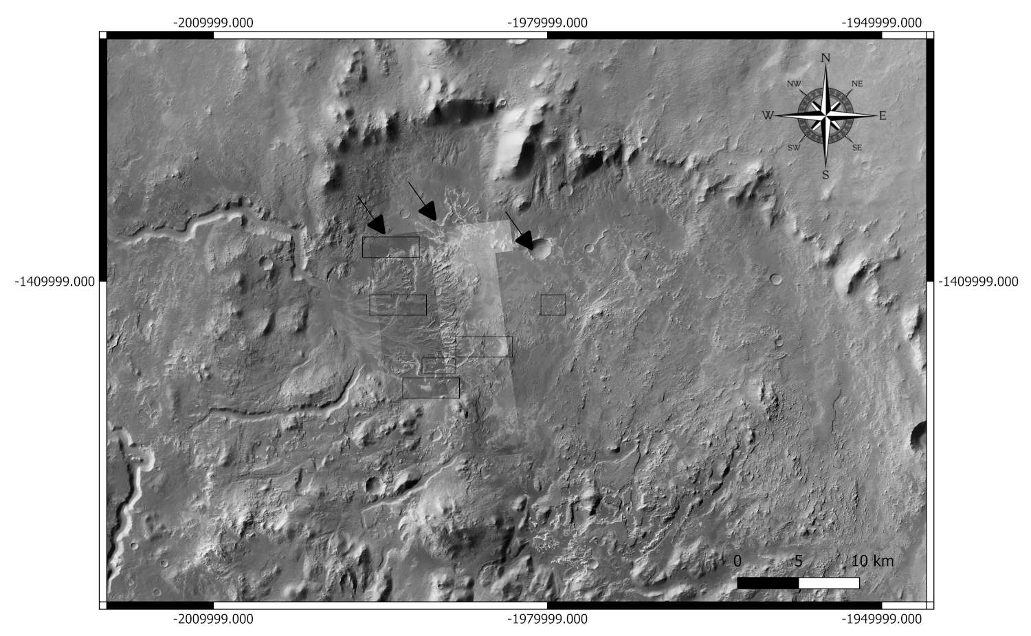
Figure 1. Study area. Black arrows indicate the DEMs used; black rectangles indicate the different areas analyzed. Background CTX mosaic.
- Preliminary results
Some specific exemplary areas where to perform a detailed mapping were selected (fig.1, black rectangles). The aeolian bedforms observed were categorized based on their morphology and stratigraphy.
Following Silvestro et al., (2020) classification, dunes, spaced approximately 260 meters apart, with heights of 1-6 meters, and megaripples, with heights of 1-2 meters and spaced 30-40 meters, were mapped.
The bedforms identified include both star and barchan dunes. The crest length of the bedforms was also measured. The wind orientation and sometimes the wind direction could be inferred (fig.2-4), providing insights into the wind dynamics at the time of their formation. At places older bedforms from an earlier wind generation coexists with recent bedforms from a later generation (fig. 3).In some cases, the more recent bedforms overlapped or truncated the older bedforms. 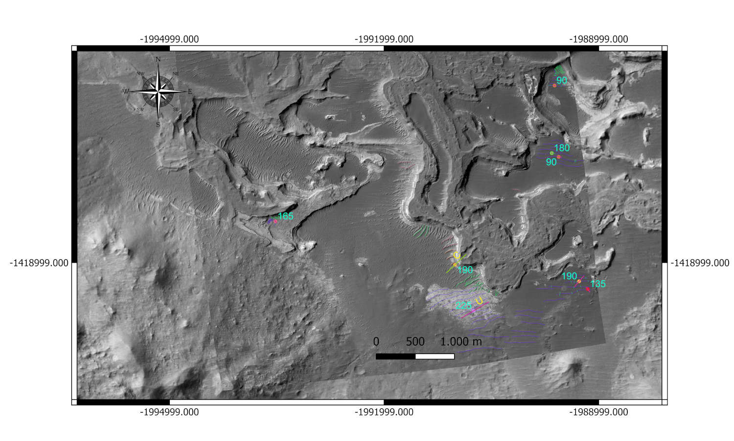
 Figure 2. Overview showing principal parameters across multiple areas, C= certain, U=uncertain,?= indefinite. Numerical values in degrees (°). (HiRISE DEM + CTX).
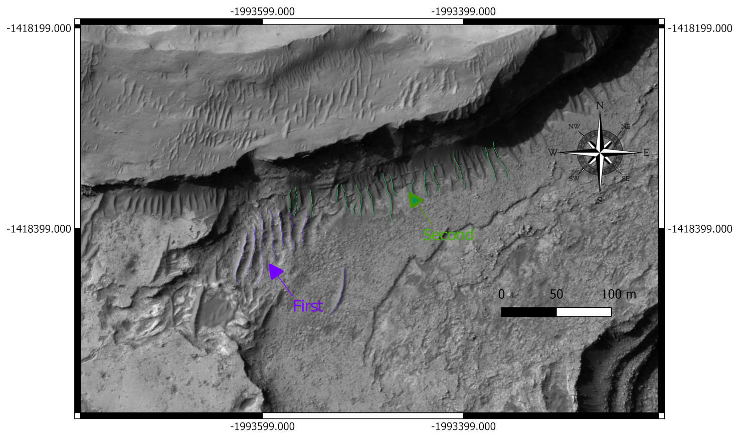
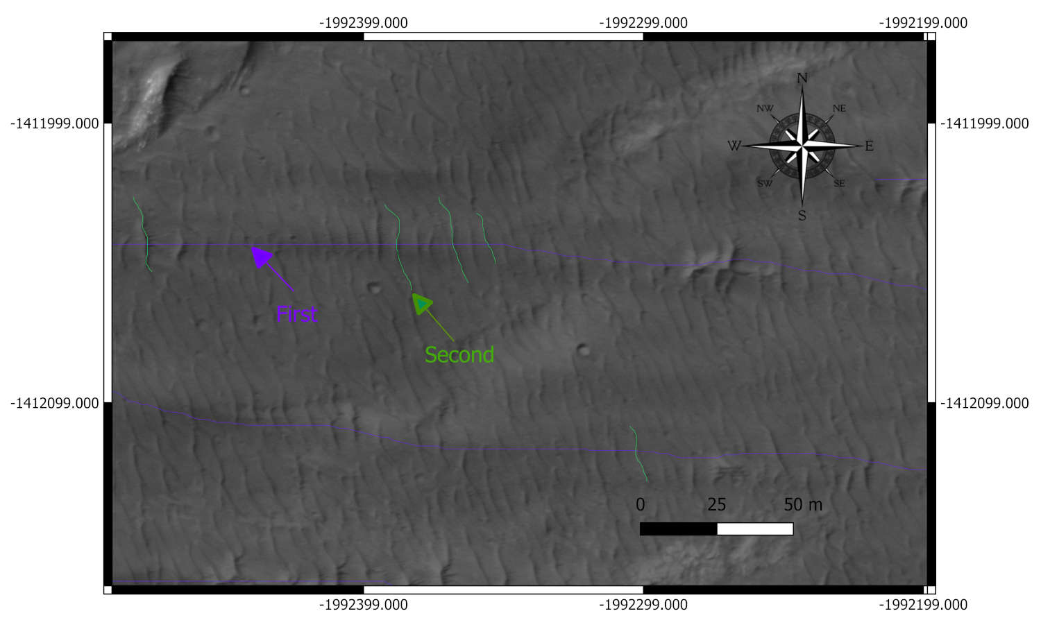
 Figure 3. The coexistence of first bedforms and second. HiRISE DEM.
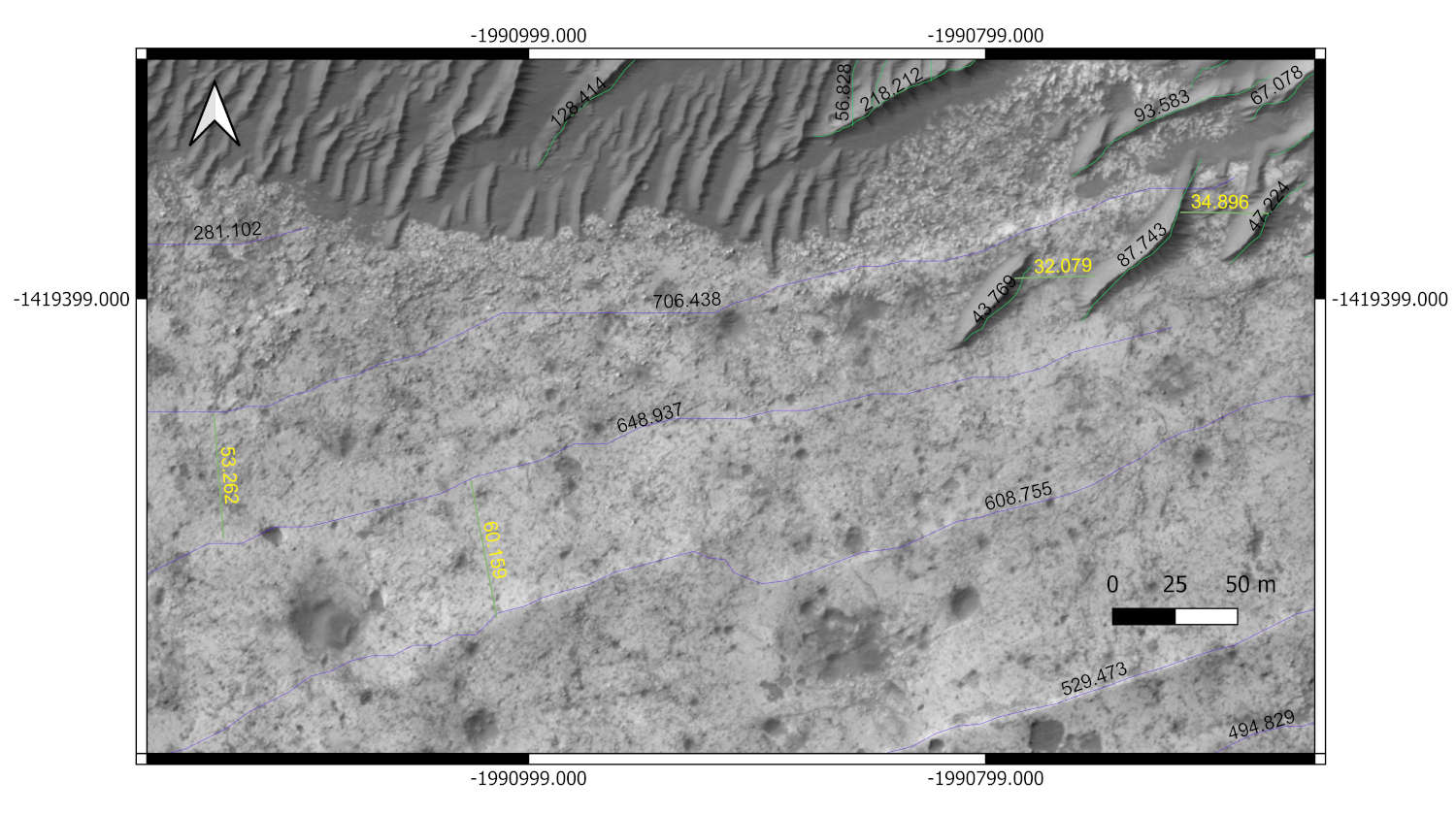
 Figure 4. Detailed view with measured crest lengths (black) and wavelengths (yellow). HiRISE DEM.
- Discussion and future work
The presence of a stratigraphic sequence of bedform deposits indicating different wind generations in the Eberswalde crater suggests a complex history of aeolian activity. The occurrence of least two distinct wind regimes, indicated by bedforms different generations, reflects depositional events driven by varying wind patterns.
The presence of star dunes suggests a dynamic environment with high wind variability, where bedforms elongate along the wind flow and display multiple orientations (Courrech du Pont et al. 2024).
Barchan dunes were also observed, with heights of about 3-4 meters, and their wavelengths varied. Longer wavelengths were associated with the older dunes generation, while shorter wavelengths corresponded to megaripples or recent dunes. It is possible that the changes in spacing indicate shifts in sediment availability.
Ongoing work will include mapping of all the Eberswalde basin in order to realize a stratigraphic column of the aeolian deposits.
Then the wind direction will be inferred for each bedform, taking into account the influence of topography, to ultimately understand wind direction changes through time. Moreover, crater size–frequency analysis will be attempted to try and date the mapped bedforms.
This will refine timing estimates for wind regimes and will constrain the changes in wind circulation pattern and their potential significance for a climatic change.
Acknowledgements
We acknowledge financial support under the National Recovery and Resilience Plan (NRRP), Mission 4, Component 2, Investment 1.1, Call for tender No. 104 published on 2.2.2022 by the Italian Ministry of University and Research (MUR), funded by the European Union – NextGenerationEU– Project Title Tanezrouft salt flat deposits (Sahara Desert): a priority target for a Mars Sample Return mission – CUP D53D23002600006 - Grant Assignment Decree No. 962 adopted on 30/06/2023 by the Italian Ministry of Ministry of University and Research (MUR).
This study was carried out within the Space It Up project funded by the Italian Space Agency, ASI, and the Ministry of University and Research, MUR, under contract n. 2024-5-E.0 - CUP n. I53D24000060005.
REFERENCES
Beyer Ross A. et al (2018) “The Ames Stereo Pipeline: NASA's open source software for deriving and processing terrain data”. Earth and Space Science, 5.
Courrech du Pont, S. et al. (2024) “Complementary classifications of aeolian dunes based on morphology, dynamics, and fluid mechanics” Earth-Science Reviews 255 (2024) 104772.
Grant, J. A. and Parker, T. J. (2002) “Drainage evolution in the Margaritifer Sinus region, Mars” Journal of Geophysical Research 107, 5066 doi:10.1029/2001JE001678.
Irwin, R. P. III, and Grant, J. A. (2011) “Geologic map of MTM -15027, -20027, -25027 and -25032 quadrangles, Margaritifer Terra region of Mars, scale 1:500,000” U.S. Geol. Surv. Sci. Invest. Map.
Laura, J. et al. (2023) “Integrated Software for Imagers and Spectrometers (7.2.0_RC1)”. Zenodo. https://doi.org/10.5281/zenodo.7644616.
Malin, M. C. and Edgett, K. S. (2003) “Evidence for Persistent Flow and Aqueous Sedimentation on Early Mars” Science 302, 1931-1934. doi:10.1126/science.1090544.
Mangold, N. (2011) “Post-early Mars fluvial landforms on mid-latitude impact ejecta” Lunar and Planetary Science XXXXII, p. 1370.
Mcwen, A.S. et al. (2007) “Mars Reconnaissance Orbiter’s High Resolution Imaging Science Experiment (HiRISE)” Journal of Geophysical Research 112, doi:10.1029/2005JE002605. E05S02.
Pondrelli, M. et al. (2008) "Evolution and depositional environments of the Eberswalde fan delta, Mars" Icarus 197, 429-451.
Rice M.S. et al. (2005) “A detailed geologic characterization of Eberswalde crater, Mars” The International Journal of Mars Science and Exploration MARS 1, 1-13, 2005; doi:10.1555/mars.2005.1.0.
Silvestro, S. et al (2020) “Megaripple Migration on Mars” Journal of Geophysical Research: Planets doi:10.1029/2020JE006446.
How to cite: Piscopo, A., Pondrelli, M., Marinangeli, L., and Cavalazzi, B.: Preliminary analysis of aeolian bedforms present in the Eberswalde preserved delta, Mars, EPSC-DPS Joint Meeting 2025, Helsinki, Finland, 7–12 Sep 2025, EPSC-DPS2025-398, https://doi.org/10.5194/epsc-dps2025-398, 2025.