
 1,1,2,3
- 1Joanneum Research, DIGITAL, Graz, Austria (piluca.caballo-perucha@joanneum.at)
- 2VRVis GmbH, Vienna, Austria (steinlechner@vrvis.at)
- 3University of Vienna. Department of Lithospheric Research , 1090 Vienna, Austria
Introduction
The Asteroid Impact & Deflection Assessment (AIDA) mission is composed of two core components: NASA’s Double Asteroid Redirection Test (DART) (1) and ESA’s Hera (2) mission.
Launched in November 2021, DART became the first spacecraft to perform an organized collision with an asteroid in an attempt to alter its orbit. The target, Dimorphos, a small moon orbiting the near-Earth asteroid Didymos, was successfully impacted on 26th of September 2022 inducing a reduction of its orbital period by 33 minutes (3).
To complement this effort and among others objectives, ESA’s Hera mission, launched on 7th October 2024, will characterize the crater formed by DART and determine the asteroid’s mass and internal structure.
The Austrian contribution to the Hera mission mainly consists of supporting the scientific camera instruments´ teams (AFC, TIRI, Hyperscout-H and ASPECT) by reconstructing, visualizing, analysing and managing in 3D the data acquired with the different instruments on board. For this purpose, new I/F tools have been developed to allow the PRo3D-GIS (4) demonstration before Hera arrival for rendezvous with the asteroid in late 2026.
Developed tools
The tools developed by the Austrian team accompany the data and metadata associated with the Hera imagery data. They consist of:
- Interfaces (I/F) required between data provided by the Hera imaging systems and the PRo3D-GIS tool
- New developments in PRo3D-GIS for visualization, analysis and interpretation of the scientific imagery data
- Establishment/provision/maintenance of the database related to the imagery data and metadata.
The validation of the tools used the data obtained by Hera imaging systems during the Earth-Moon observations (October 2024) and Mars fly-by (12th March 2025), in association with the Mars MOLA (5), Deimos and Phobos SDKs DTMs (6). For Hera trajectory representation, the last version of the operational SPICE kernels provided by ESAC on 14th April 2025 (6) was applied.
Interfaces for sensors imagery data
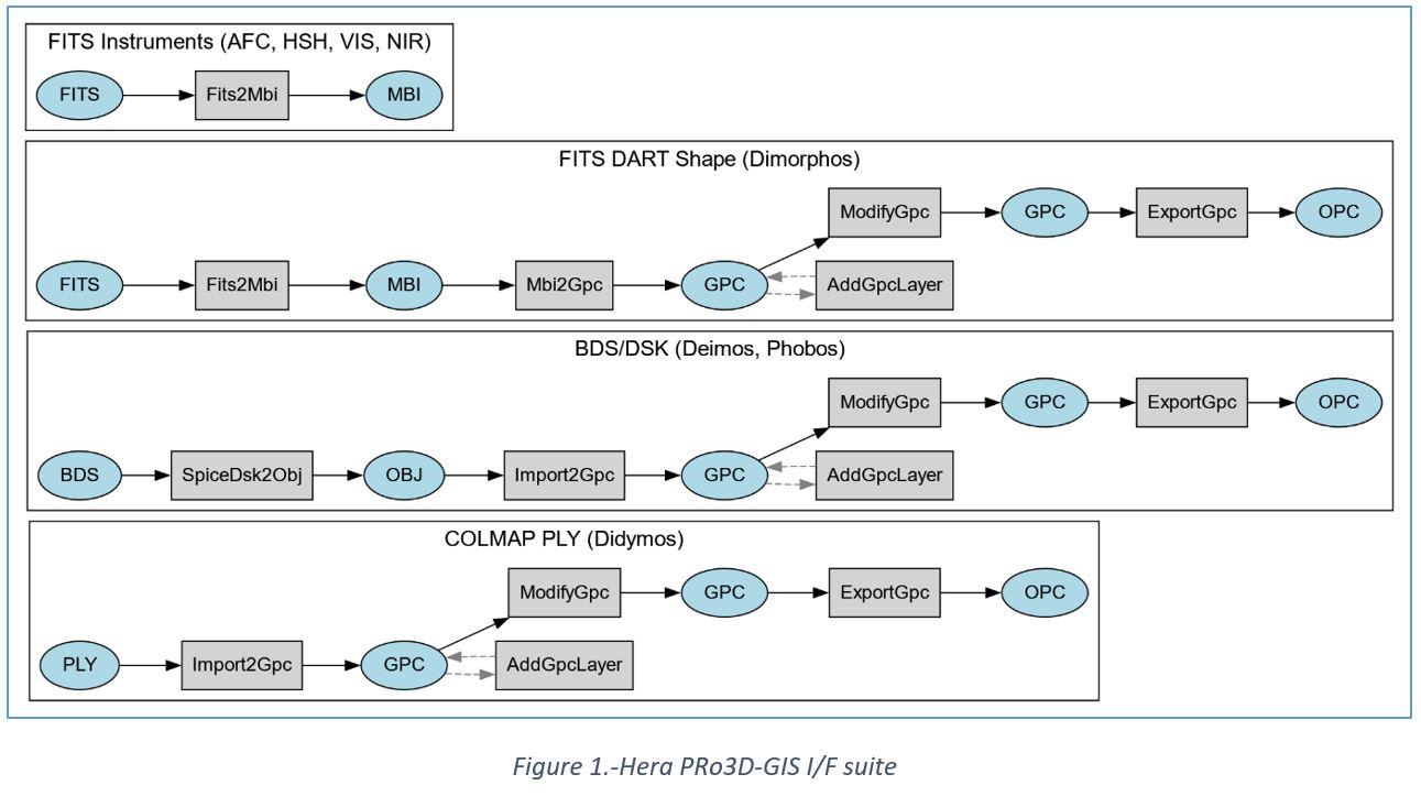
The I/F activities are related to the development and upgrade of tools for the conversion of the Hera instruments data into the generation of Ordered Point Cloud format (OPC) (7) required by PRo3D-GIS (Figure 1):
- Mission I/F
- Import of FITS instruments’ data (images)
- Conversion of SPICE digital shape models (as e.g.: Deimos or Phobos)
- Conversion of FITS (optionally multilayer) shape models (e.g.: DART Dimorphos shape model)
- Conversion of the JR reconstructed shape models (e.g. COLMAP Didymos reconstruction)
- Update of an already existing OPC
- Instruments I/F
- Import of Hera imaging instruments’ geometry (e.g.: instrument inner orientation: FoV, focal lengths)
PRo3D-GIS operations
PRo3D-GIS is designed to support the instrument teams in 3D-related mission operations. The tool is based on PRo3D, an interactive 3D visualization tool to allow planetary scientists to work with high-resolution 3D reconstructions (8,9). The PRo3D-GIS extension with the support for multiple celestial bodies as required for the Hera mission was presented in 2024 (10). The system was extended with interactive projections of calibrated sensor images by introducing the following features:
- Visualization configuration and management of celestial bodies required for a specific mission scenario: use of so-called proxy-geometries whenever no high-quality reconstruction is available combined with OPC 3D reconstructions, allows to visualize trajectories, navigate in time and space and perform annotations on the surfaces.
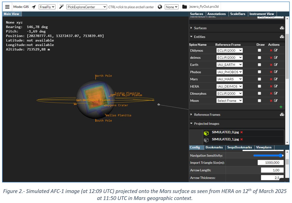
- View simulation: The tool allows to simulate views for a scenario (based on visualization properties, see above) and the FoV of a particular instrument (Figure 2). This enables the validation of the registration and scene setup for the mission and allows spatial understanding of literally each individual image pixel on the 3D asteroid surface. This allows also to look at particular sensor images from different views and play scenarios such as: what feature is seen from what instrument in what particular setting.
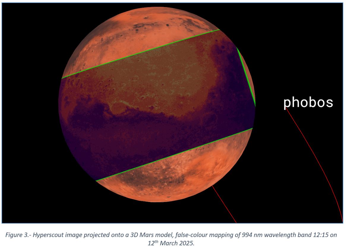
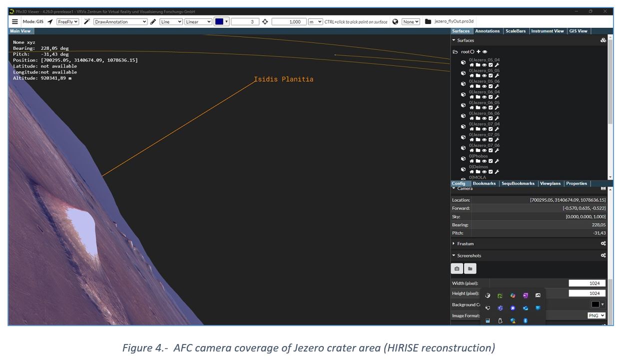
- Sensor image projections. This feature allows to project instrument images onto the surfaces of the scene (Figure 3). The images can be switched through interactively as well as the viewing point (Figure 4).
3D GIS Database
A virtual machine for the Hera DBMS (Data Base Management System) is procured and set up to run as a central instance available to mission operations, hosting all relevant services DBMS services:
- The database itself: a PostgreSQL instance with both PostGIS and pgstac extensions
- The API: an instance of the stac-fastapi software, serving the data stored in the database layer via the STAC API protocol
- The reverse proxy: serves as both a file server to provide access to the raw data and the metadata files as well as a file based browsing interface
- The client: a configured instance of the stac-browser software configured to direct access the API
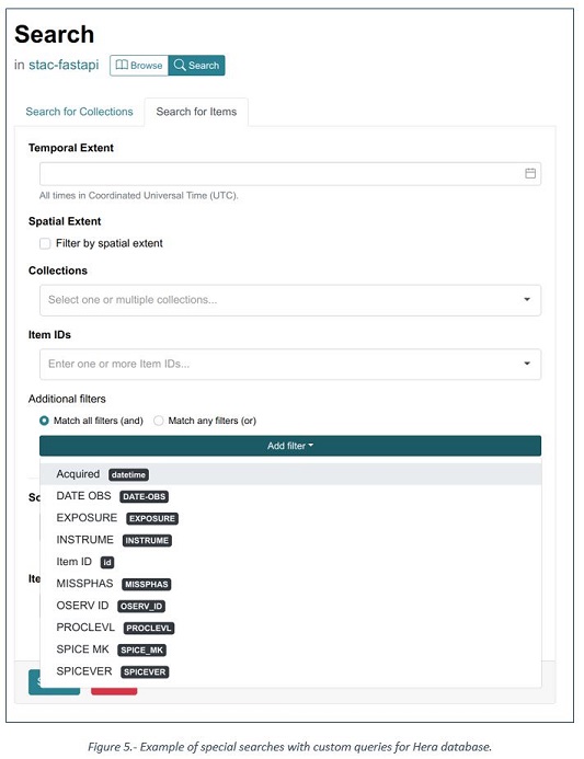
The database uses collections to partition the ingested items. It is possible to search within or even across these collections. Furthermore, the client is a freely accessible web app. The UI allows users to visually explore the contents of the catalogs. Additionally special searches with custom queries on the previously defined metadata fields can be made (Figure 5). The mission phase Mars fly-by was supported by performing the ingestion flow and served as a proof of concept of the whole ingestion pipeline.
Summary and further work
Further activities are still under development, being prepared for the arrival of Hera at the end of 2026. The Austrian team is currently working in the post-processing of Mars fly-by multispectral images of the Hyperscout-H sensor, as well as with TIRI images, for the correct visualization in PRo3D-GIS. The integration of ASPECT data will be finalized by the arrival of Hera to Dimorphos and following tasks are also planned:
- Export of Region of Interest in 3D
- Data base import/export from/to central mission repository
- Ingestion of AFC images and calibration data into the reconstruction pipeline PRoViP-COLMAP
- Data base maintenance: new reconstructed shape model, new instruments calibrations, SPICE versions
- Bookmarks and videos
- Coordinates transformation (geographic into equi-rectangular and vice versa)
- Export of ortho image with annotations performed in the PRo3D-GIS
How to cite: Caballo Perucha, M. P., Steinlechner, H., Paar, G., Traxler, C., Kup, D., and Koeberl, C.: Design of a visualization and analysis tool for Hera scientific mission, EPSC-DPS Joint Meeting 2025, Helsinki, Finland, 7–12 Sep 2025, EPSC-DPS2025-480, https://doi.org/10.5194/epsc-dps2025-480, 2025.