
 1,1,3,
- 1LATMOS, UVSQ, Guyancourt, France
- 3TUD, Dresden, Germany
- 4ETH, Zürich, Switzerland
- 5UNIS, Longyearbyen, Svalbard
Introduction
The investigation of the subsurface of Mars provides key insights into its geological history and reveal signs of extinct life. This is why the ExoMars/Rosalind Franklin rover mission has been designed to search for biosignature in the subsurface of Oxia Planum [1], especially thanks to a drill [2] able to collect samples down to 2 m below the surface. The WISDOM GPR [3] aboard the rover will guide the the selection of suitable and safe underground targets. For this purpose, WISDOM will probe the Martian subsurface at frequencies in the 0.5-3 GHz range, guaranteeing a centimetric resolution and a penetration depth of a few meters.
Field test campaigns in partially controlled or natural environments are of the outmost importance to assess WISDOM performance and validate the data processing chain. This paper presents interpretation tools developed and applied to experimental data acquired with the flight spare model of WISDOM during a field test campaign in Svalbard in March 2022. Svalbard already hosted the AMASE campaigns [4] between 2007 and 2011 to prepare the ExoMars mission. Svalbard’s permafrost is very favourable to the penetration of waves and the main goal of this campaign was to collect data in a well-documented geological and glaciological environment [5;6]. Besides, the regions includes polygonal terrains, caves and outcrops that can be regarded as relevant Martian analogues.
Svalbard field test location
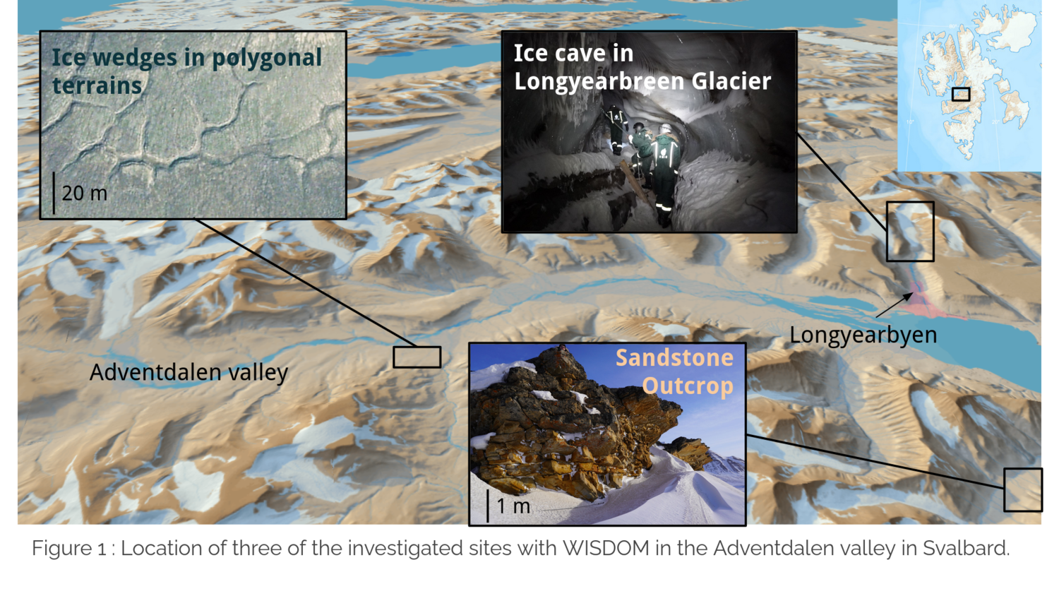
The WISDOM data presented in this paper have been acquired in March 2022 in the Adventdalen Valley, near Longyearbyen. The map Fig. 1 shows 3 investigated terrains namely
(i) Ice cave meanders 6 to 10 m deep inside the glacier.
(ii) A heavily fractured sandstone outcrop (25-m long profile). Outcrops will be amongst the ExoMars rover's priority targets to drill and seek for biosignature.
(iii) A polygonal terrain (four parallel lines crossing two polygon troughs).
WISDOM data interpretation methods
The up-to-date WISDOM processing chain was applied to the data [7]. In addition, electromagnetic simulations were conducted to characterize the shape, dimensions and permittivity value of detected buried structures. Simulations are performed with TEMSI-FD, a 3D Finite Difference Time domain (FDTD) code [8] which can account for the actual radiation pattern of WISDOM antennas.
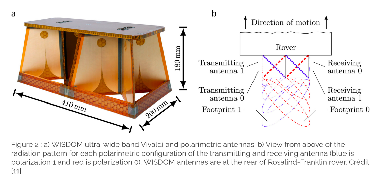
We also exploit the different polarization configuration measurements of WISDOM to constrain the geometry and the shape of detected targets. For instance, spherical targets have a low depolarisation efficiency whereas angular and corner reflectors are strongly depolarizing. Tilted interfaces change the direction of propagation of the waves as well as its polarization. To display the intensity in the different WISDOM polarimetric configurations, we produce additive RGB synthesis radargrams [7] by combining three of the four polarization configurations presented on Fig. 2. The different radiation patterns in polarization 0 and 1 (Fig. 2) allow to constrain the position of the red (only 00) and green (only 11) reflections to the right rear and left rear of the rover traverse respectively.
We use in a complementary way the Bandwidth Extrapolation (BWE) technique, a super-resolution method [9;10] which can improve the range resolution of WISDOM radargrams by a factor 3, allowing to meet the requirements of the ExoMars mission in materials of relatively low permittivity value.
Results
This section illustrates the use of simulations and polarimetric analysis on Svalbard data.
Contribution of 3D simulations to quantified interpretation
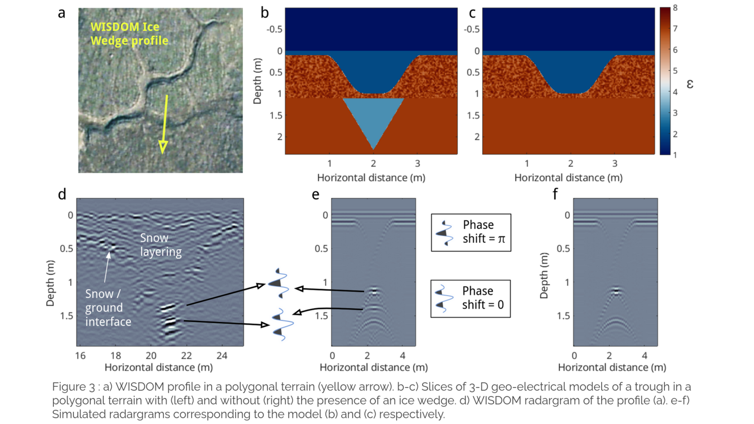
Fig. 3b and 3c present a vertical slice of a 3D geo-electrical model representative of the trough (with and without ice wedge underneath) separating two polygons in the polygonal terrain investigated with WISDOM (profile in yellow on Fig. 3a). Fig. 3e-f shows the corresponding simulated radargrams, which are compared to the experimental radargrams (Fig. 3d).
In both experimental and simulated data, snow/trough interface reflection weakens and disappears when the interface slope becomes too steep. The main contribution of these simulated radargrams is to remove ambiguity about the 3 intense reflections around 1.5 m deep. The middle reflection cannot be explained without the presence of an ice wedge, and the deepest signals are actually due to double reflections on the faces of the trough. The phase shift reported on Fig. 3d-3e supports the hypothesis that WISDOM waves travelled through a lower permittivity material, consistent with the presence of an ice body (ε=3.2) beneath the active layer material (ε≥7).
Polarimetric analysis of the data
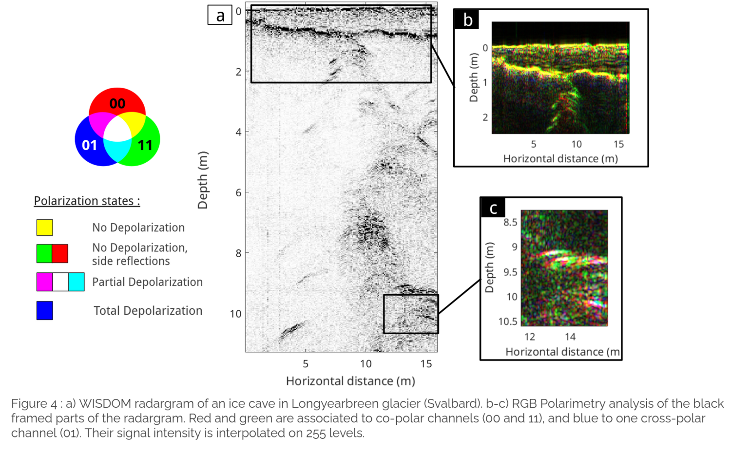
The RGB display of the WISDOM radargram acquired above the ice cave of the glacier (Fig. 4a) reveals a variety of polarimetric signatures. Snow layers and snow/ice interface appear yellow (Fig. 4b) ; they are almost horizontal and relatively smooth, thus not depolarizing. From 1.5 to 2.5 m deep on Fig 4b reflections are either red or green; these structures are therefore off-track (not directly underneath the antennas). These features are nevertheless not depolarizing. In contrast, the received waves associated with the ice cave (Fig. 4c) are rather depolarized, meaning they may have experienced multiple reflections in the cavity.
Conclusion
The Svalbard data set allows to validate the WISDOM performances and the interpretation tools. The fine range resolution meets the mission’s requirements and the polarimetry constrains the position and shape or nature of buried reflectors, which is essential for the selection of the drill site. Simulations and polarimetry provide together quantified analysis of the subsurface structures, which will significantly contributes to the geological understanding of the site in synergy with the instruments of the payload. WISDOM will investigate the Martian subsurface in a complementary way to the lower frequency and non-polarimetric GPR RIMFAX and to RoPeR.
References
[1] C. Quantin-Nataf et al., Astrobiology, 2021
[2] F. Altieri et al., Advances in Space Research, 2023
[3] V. Ciarletti et al., Astrobiology, 2017
[4] A. Steele et al., AGU Fall Meeting Abstracts, 2010
[5] M. Ulrich et al., Geomorphology, 2011
[6] N. Ross et al., Norwegian Journal of Geography, 2005
[7] Y. Herve, PhD Thesis, 2018
[8] C. Guiffaut et al., IEEE, 2012
[9] K.M. Cuomo, NASA STI/Recon Technical Report N, 1992
[10] N. Oudart et al., Planetary and Space Science, 2021
[11] W-S. Benedix et al., Planetary and Space Science, 2024
How to cite: Brighi, É., Ciarletti, V., Le Gall, A., Oudart, N., Hervé, Y., Plettemeier, D., Benedix, W.-S., Mas i Sanz, E., Shestov, A., Mercier, L., and Harrar, L.: Performance validation of WISDOM, the GPR of the ExoMars 2028 mission, on a Martian analogue dataset acquired in Svalbard, EPSC-DPS Joint Meeting 2025, Helsinki, Finland, 7–12 Sep 2025, EPSC-DPS2025-710, https://doi.org/10.5194/epsc-dps2025-710, 2025.