
 1,1,1,1,1,2
- 1IRSPS, Department of Engineering and Geology, University “G. d'Annunzio” Chieti-Pescara, Pescara, Italy (monica.pondrelli@unich.it)
- 2Department of Biological, Geological and Environmental Sciences, University of Bologna, Bologna, Italy
Introduction
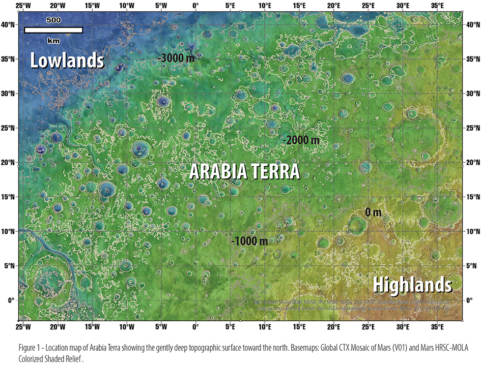
The documented climate change on Mars between the late Noachian and the Hesperian marked a shift from relatively humid to arid-cold conditions (e.g., McLennan et al., 2019 and references therein). While the broad trajectory of this evolution is established, the controlling factors, the contribution of periodic versus episodic events, and the precise timing remain largely unresolved. Sedimentary deposits are key archives of past environments and of their changes through time. Arabia Terra represents a key region for analyzing these records. Unlike most of Mars, it is a gently sloping region that links southern highlands and northern lowlands (Fig. 1), allowing for a more extensive distribution of sedimentary environments. Moreover, the region hosts abundant and well-preserved sedimentary landforms and deposits exhibiting stratigraphic, geomorphological, and mineralogical characteristics (e.g., Pondrelli et al. 2015; Davis et al., 2016; Salese et al., 2019; Schmidt et al., 2021). We aim to reconstruct the lateral distribution (environment associations) and vertical evolution (stratigraphic trend) of these deposits and morphologies. Here, we present our preliminary results based on both new analyses and critical reassessment of existing literature, with the goal of defining the elements for a future cartographic legend.
Data and Methods
Our approach combines regional-scale and basin-scale analyses. At the regional level, we employed Thermal Emission Imaging System (THEMIS) imagery (resolution ~100 m/pixel) and Context Camera (CTX) data (~6 m/pixel), supported by digital elevation models (DEMs) derived from High Resolution Stereo Camera (HRSC) data (~50 m vertical resolution). For finer-scale analyses, in areas with pristine preservation of deposits/features and high-resolution data availability, CTX data were integrated with High Resolution Imaging Science Experiment (HiRISE) images (~30 cm/pixel). Topographic data at this scale were obtained using stereo-pairs from CTX (~12 m/pixel vertical resolution) and HiRISE (~1 m/pixel vertical resolution), processed with NASA’s Ames Stereo Pipeline. Preliminary compositional data were derived from the Mars ACT-REACT QuickMap interface, allowing for the identification of mineral phases based on CRISM data.
Sedimentary Deposits in Arabia Terra
Sedimentary materials in Arabia Terra dating to the Noachian and Hesperian periods can be broadly classified into two main types: fluvio-lacustrine deposits, which are relatively well understood in terms of origin and processes and light-toned layered deposits (LTDs), whose genetic interpretations remain debated.
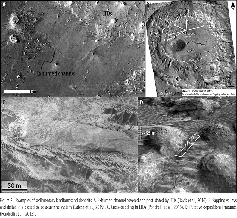
Phyllosilicate-bearing fluvial channels have been documented in intercrater plains (e.g., Davis et al., 2016), sometimes forming part of open-lake systems. These channels can be either incised or exhumed, reflecting the differential erosion of previously existing floodplain sediments (Fig. 2A). Closed paleolacustrine systems have been observed within deep craters (Salese et al., 2019), hydrologically isolated from surrounding intercrater plains and interpreted to have been fed primarily by groundwater upwelling through sapping channels (Fig. 2B). Deltas associated with these systems show evidence for water level fluctuations, ultimately culminating in lake-level decline and desiccation.
The fluvio-lacustrine systems are locally overlain by LTDs in both intercrater and intracrater settings (Fig. 2A). Intercrater LTDs display etched or flat-lying surfaces shaped by wind erosion, though locally they show duneforms and evidence of cross-bedding. LTDs mineralogy shows a latitudinal trend: phyllosilicates dominate in northern Arabia Terra, while sulfates are more common in the south. In some locations, a gradual vertical transition from clay-rich to sulfate-rich layers has been identified, reminiscent of those documented in Meridiani Planum (Flahaut et al., 2015).
Intracrater LTDs can form crater bulges or flat surfaces and may display features such as terraces or erosional bedrock channels cutting the inner crater rim (Fig. 2C). Their thickness appears to decrease northward (Schmidt et al., 2021), reaching > 2 km where crater-centered bulges are developed (Pondrelli et al., 2015).
Some LTDs may have formed in hydrothermal settings. This hypothesis is supported by the presence of mineral assemblages such as Mg–Fe phyllosilicates and carbonates (Michalski et al., 2013), as well as by the occurrence of filled fractures and mounds that suggest fluid expulsion. Although some of these features may be erosional remnants, others appear as depositional (Fig. 2D), based on their shape and their relationships with potential erosional patterns (i.e., wind direction).
Future Work
The next phase will involve systematic mapping of the distribution of the presented elements at a regional scale with associated metadata, including their geometries (qualitative-quantitative), stratigraphic relationships, and compositional characteristics. Depositional processes and stratigraphic evolution will be refined using detailed geological mapping of selected key areas. In addition, published geologic maps will be updated to incorporate recent hyperspectral data into the legend description.
Acknowledgments
We acknowledge financial support under the National Recovery and Resilience Plan, Mission 4, Component 2, Investment 1.1, Call for tender No. 104 published on 2.2.2022 by the Italian Ministry of University and Research, funded by the European Union – NextGenerationEU–Project Title Tanezrouft salt flat deposits (Sahara Desert): a priority target for a Mars Sample Return mission – CUP D53D23002600006 - Grant Assignment Decree No. 962 adopted on 30/06/2023 by the Italian Ministry of Ministry of University and Research.
This study was carried out within the Space It Up project funded by the Italian Space Agency, ASI, and the Ministry of University and Research, under contract n. 2024-5-E.0 - CUP n. I53D24000060005.
References
Davis, J. M., Balme, M., Grindrod, P. M., Williams, R. M. E., & Gupta, S. (2016). Extensive Noachian fluvial systems in Arabia Terra: Implications for early Martian climate. Geology, 44(10), 847–850. https://doi.org/10.1130/g38247.1
Flahaut, J., et al. (2015). Embedded clays and sulfates in Meridiani Planum, Mars. Icarus, 248, 269–288. https://doi.org/10.1016/j.icarus.2014.10.046
McLennan, S. M., et al. (2019). The Sedimentary Cycle on Early Mars. Annu. Rev. Earth Planet. Sci., 47, 91–118. https://doi.org/10.1146/annurev-earth-053018-060332
Michalski, J. R., et al. (2013). Groundwater activity on Mars and implications for a deep biosphere. Nature Geoscience, 6(2), 133–138. https://doi.org/10.1038/ngeo1706
Pondrelli, M., et al. (2015). Equatorial layered deposits in Arabia Terra, Mars: Facies and process variability. GSA Bulletin, 127(7/8). https://doi.org/10.1130/B31225.1
Salese, F., et al. (2019). Geological Evidence of a Planet-Wide Groundwater System on Mars. JGR Planets, 124(2), 374–395. https://doi.org/10.1029/2018je005802
Schmidt, G., et al. (2021). Depositional controls of the layered deposits of Arabia Terra, Mars: Hints from basin geometries and stratigraphic trends. JGR Planets, 126(11). https://doi.org/10.1029/2021je006974
How to cite: Pondrelli, M., Salese, F., Mancini, F., Caddeo, Y., Piscopo, A., Kokin, O., Ranieri, B., and Cavalazzi, B.: Noachian-Hesperian Sedimentary Evolution of Arabia Terra, Mars: Preliminary Insights, EPSC-DPS Joint Meeting 2025, Helsinki, Finland, 7–12 Sep 2025, EPSC-DPS2025-746, https://doi.org/10.5194/epsc-dps2025-746, 2025.