
- 1College of Surveying and Geoinformatics, Tongji university, Shanghai, China (2210937@tongji.edu.cn)
- 2Shanghai Key Laboratory for Planetary Mapping and Remote Sensing for Deep Space Exploration, Shanghai, China
1. Introduction
Accurate and high-resolution digital elevation models (DEMs) are essential for Martian landing site selection and geological analysis [1]. However, existing photogrammetric DEMs suffer from low resolution and limited coverage[2]. Traditional shape from shading (SfS) recovers pixel-scale terrain details based on surface reflectance model[3]. However, Martian atmospheric scattering distort image brightness, making it unreliable for representing actual terrain-induced variations, thereby reducing reconstruction reliability[3,4]. Current atmospheric correction methods rely on external sources such as the Mars Climate Database (MCD), or estimated through optimization, which are resolution-limited and unstable[5,6]. To address these limitations, a novel single-image shape from shading method with atmospheric correction (SI-AC-SfS) is proposed to generate high-resolution DEMs by integrating reflectance model into an atmospheric framework[6]. It estimates optical depth using a shadow-based inversion and simulates scattering parameters via the Discrete Ordinate Radiative Transfer (DISORT), eliminating reliance on external products[7]. Applied to a single Context Camera (CTX) image and a low-resolution DEM, it generates a high-resolution DEM with enhanced surface detail and higher accuracy compared to traditional SI-SfS, as validated against the HiRISE reference DEM.
2. Method
The proposed SI-AC-SfS method aims to reconstruct high-resolution DEMs of the Martian surface with improved geometric accuracy by correcting for atmospheric effects. The overall workflow comprises three main steps: 1) joint modeling of atmospheric scattering and surface reflectance; 2) atmospheric parameter estimation from image information and DISORT; and 3) construction and optimization of the SI-AC-SfS loss function. The method takes as input a single preprocessed CTX image and a low-resolution DEM and produces a refined high-resolution DEM.
3. Test data
The experimental analysis of the proposed SI-AC-SfS method was conducted using a single CTX image (6 m/pixel) and the corresponding photogrammetric DEM (20 m/pixel) to generate a high-resolution DEM (6 m/pixel). Evaluation was performed against a HiRISE DEM (1 m/pixel). The study site, located at the Perseverance rover landing site in Jezero Crater (18.41°N, 77.69°E), spans 7.08 km × 2.94 km. The CTX image was preprocessed (e.g., radiometric calibration) using ISIS3 software and manually registered to the photogrammetric DEM. Atmospheric optical depth and scattering parameters of the CTX image were estimated using a shadow-based inversion method and DISORT simulations, respectively. Table 1 summarizes the CTX image properties and atmospheric conditions.
Table 1. Basic information of the used image in the experimental
| Image ID | Image time | Incidence angle | Emission angle | Pixel resolution | solar azimuth | Optical Depth |
|
F05_XN_20N282W |
2014-08-16 |
57.34° |
8.88° |
5.62m |
256.49° |
0.32 |
4. Results
Figure 1 shows the input, generated, and reference DEMs. Both SI-SfS and SI-AC-SfS results contain more detailed information compared to the photogrammetric DEM, demonstrating their ability to reconstruct fine-scale topography. However, it is important to note that hillshade images reflect only enhanced surface details, and the geometric accuracy of the reconstructed DEM must be quantitatively assessed using a reliable reference DEM.
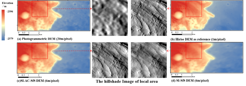
Figure 1. The input photogrammetric DEM and the generated DEM.
Table 2 summarizes the quality metrics of different DEMs. Although the traditional SI-SfS method yields a high PCC (0.83), it exhibits a larger RMSE than the initial DEM, indicating that uncorrected atmospheric scattering leads to visually plausible but geometrically inaccurate results. In contrast, the proposed SI-AC-SfS method achieves the lowest RMSE (3.74 m), MAE (2.91 m), and MAD (19.33 m) when compared with the HiRISE DEM. These results demonstrate that while SI-SfS enhances surface detail, atmospheric correction is crucial for ensuring geometric accuracy in high-resolution Martian DEMs.
Table 2. Overall quality metrics of the different DEMs.
|
Photogrammetric DEM |
SI-SfS DEM |
SI-AC-SfS DEM |
HiRISE DEM |
|
|
RMSE(m) |
4.03 | 4.09 | 3.74 | N/A |
|
MAE(m) |
3.12 | 3.12 | 2.91 | N/A |
|
MAD(m) |
24.75 | 20.89 | 19.33 | N/A |
|
PCC |
0.63 | 0.83 | 0.84 | 0.79 |
RMSE represents root mean square error; MAE represents mean absolute error; MAD represents maximum absolute deviation; PCC represents pearson correlation coefficient.
5. Discussion and Conclusion
Figure 2 presents a profile comparison from different DEMs to assess the effect of atmospheric correction. In the traditional SI-SfS result, image brightness caused by atmospheric scattering is misinterpreted as terrain variation, resulting in inaccurate elevation reconstruction at points A and B. In contrast, the proposed SI-AC-SfS DEM profile aligns more closely the HiRISE DEM, with a lower MAD (3.32 m) than SI-SfS (5.19 m) and the photogrammetric DEM (3.46 m).
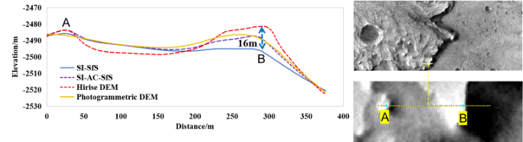
Figure 2. Profile comparison across different DEMs.
This study proposes the SI-AC-SfS method, which integrates an atmospheric scattering framework with optical depth and scattering parameters derived through a shadow-based inversion and DISORT simulation, effectively overcoming the traditional SI-SfS limitation of misinterpreting image brightness caused by atmospheric scattering as terrain variation. The experimental results demonstrate that the proposed SI-AC-SfS method is effective in generating reliable, high-resolution DEMs on Mars, providing critical support for future exploration missions. Future work will focus on the extension to a multi-image shape and albedo from shading framework with atmospheric correction to more effectively account for atmospheric scattering and albedo variations.
Acknowledgements
This work was supported by the National Natural Science Foundation of China under Grants 42221002 and 42101447. The authors would like to thank the MRO CTX and HiRISE teams (htt ps://ode.rsl.wustl.edu/mars/), as well as the developers of the open-source DISORT (https://github.com/LDEO-CREW/Pythonic-DISORT) and ISIS3 (https://isis.astrogeology.usgs.gov/).
References
[1] Lorenz R D. 2023. AdSpR. 71. 1. [2] Heipke C, Oberst J, Albertz J, et al. 2007. P&SS. 55, 14. [3] Alexandrov, O., & Beyer, R. A. 2018. E&SS. 5, 652. [4] Qian, J., Ye, Z., Qiu, S., et al. 2025. Icar, 25, 116494. [5] Liu, W. C., & Wu, B. 2023. JPRS. 204, 237. [6] Hess, M., Tenthoff, M., Wohlfarth, K., & Wöhler, C. 2022. JIm. 6, 158. [7] Shaheen, F., Scariah, N. V., Lala, M. G. N., et al. 2022. Icar. 388, 115.
How to cite: Qian, J., Ye, Z., Xu, Y., Huang, R., and Tong, X.: Single-image Shape and from Shading with Atmospheric Correction for Precise Topographic Reconstruction on Mars, EPSC-DPS Joint Meeting 2025, Helsinki, Finland, 7–12 Sep 2025, EPSC-DPS2025-849, https://doi.org/10.5194/epsc-dps2025-849, 2025.