
 1,2,
1,2,- 1Johns Hopkins University Applied Physics Laboratory, Laurel, United States of America (kristian.chan@jhuapl.edu)
- 2University of Texas Institute for Geophysics, Austin, TX, USA
- 3Brabants Radars, Brussels, Belgium
Mechanisms hypothesized for the formation of notable geologic features on Europa (e.g., chaos terrains) can alter the surrounding icy regolith to depths of a few meters to tens of meters (i.e., the near-surface) [1]. On Ganymede, variations in bulk composition and porosity may exist across the surface indicative of impact erosion and mass wasting processes [2]. The ability to characterize these compositional and physical properties (e.g., porosity), particularly in the context of its surface geology, provides a window into processes governing the evolution of their icy regoliths, both spatially and with depth.
The application of radar reflectometry to study the ‘surface’ return from sounders has been demonstrated to be a promising technique for characterizing near-surface ice on Earth and Mars [3, 4]. Such an approach can also be applied to future observations from the Europa Clipper and JUICE missions, both currently en route to the Jovian system. Both missions host nadir-pointing ice-penetrating radars: the Radar for Europa Assessment and Sounding: Ocean to Near-surface (REASON) on Europa Clipper [5] transmitting simultaneously at center frequencies of 60 MHz and 9 MHz, with bandwidths of 10 MHz and 1 MHz, respectively, and the Radar for Icy Moons Exploration (RIME) on JUICE [6] at 9 MHz center frequency with a bandwidth of 1 or 2.8 MHz.
Prior work used to investigate bulk near-surface properties and surface roughness relied on characterizing the coherent and incoherent content encompassed in the total surface return [7]. They utilized radar observations collected at near constant altitude (h). However, Europa Clipper and JUICE will perform flybys throughout their nominal tours, where altitude rapidly changes across the observation window. Thus, understanding how changes in altitude can affect the balance between observed coherent and incoherent backscattered energy is needed to confidently apply reflectometry for these missions.
Here, we simulate the radar surface echo from synthetic terrains, using a version of the multilayer Stratton-Chu coherent simulator with rough facets [8]. We assess the coherent content of the total surface power to changes in altitude and surface roughness, by comparing the power derived from simulated surface echoes at 9 MHz center frequency (Fig.1). Coherent and incoherent power falls off at different rates (h2 versus h3, respectively) with increasing altitude [9]. The coherent content of the total return at a particular altitude over the target of interest could be utilized to invert for near-surface properties. Therefore, increasing platform altitude could be leveraged as a natural filter to establish stable coherent returns.
We further validate this approach for reflectometry with ice-penetrating radar data collected over Beardmore Glacier, Antarctica. These data were collected with the Multifrequency Airborne Radar-sounder for Full-phase Assessment (MARFA) instrument, a 60 MHz airborne radar sounder operated by the University of Texas Institute for Geophysics [10]. This particular groundtrack was flown to incorporate altitude variations that scale with the center frequency of the HF channel of RIME and REASON. We find that power fall-off is neither entirely proportional to h2 nor h3 (Fig. 2). This suggests that the surface return consists of both coherent and incoherent energy, perhaps characteristic of cracks and crevasses as well as changes in firn porosity (i.e., icy regolith) across the glacier’s surface. In the case of RIME and REASON, this work implies that different terrain types (e.g., chaos terrains versus ridged plains on Europa) may be better observed at certain altitudes from the perspective of reflectometry. In addition, our results can provide insight into favorable targets and altitudes suitable for cross calibrating RIME and REASON at their shared center frequency and bandwidth to enable comparative radar studies across the Jovian icy moons. This science objective has been recommended in the latest JUICE-Clipper Steering Committee (JCSC) orbital report.
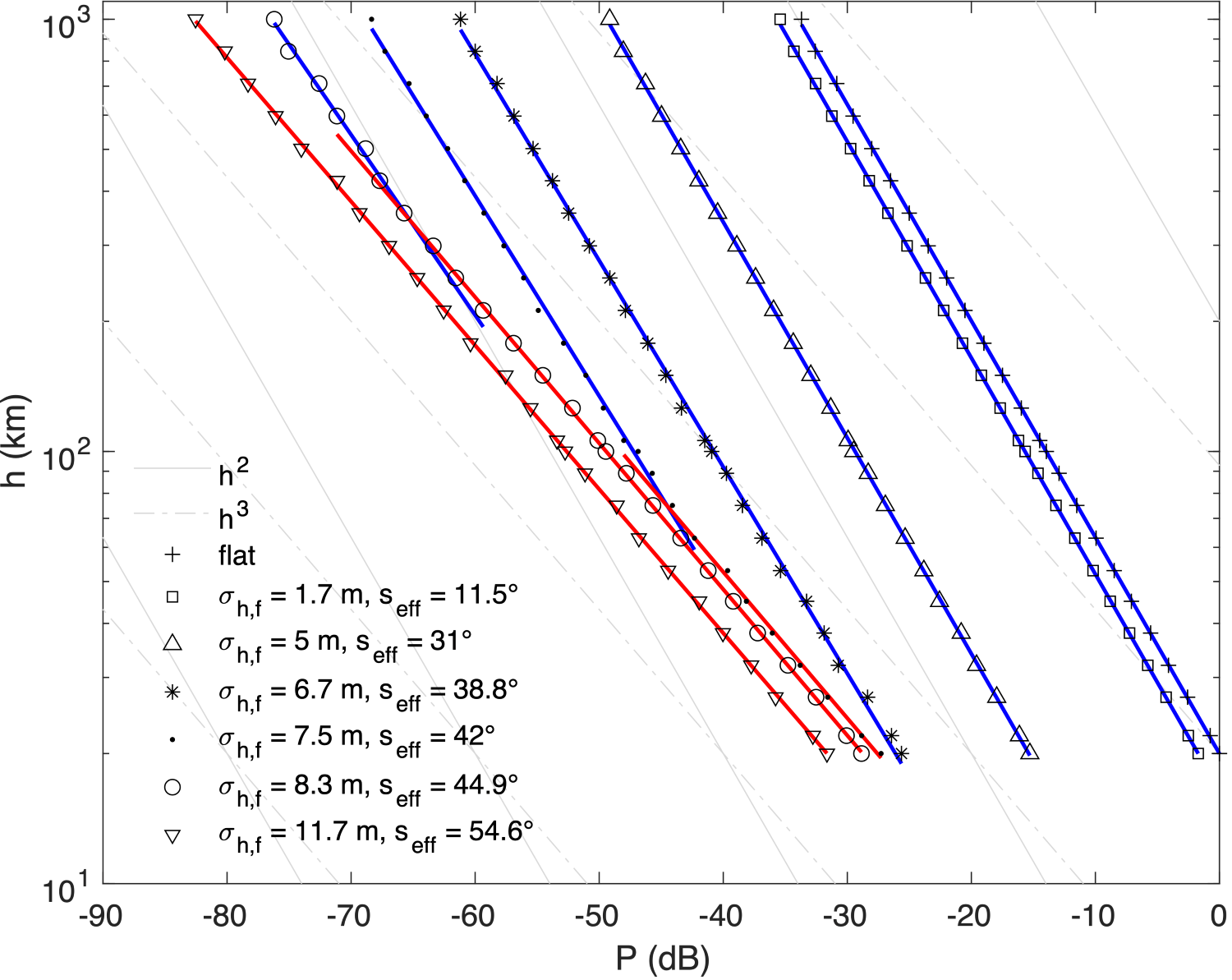
Fig 1. Simulated surface power (P) for synthetic terrains with stationary surface roughness, for altitudes ranging from 20 to 1000 km. Simulations were conducted with correlation length lc = 0.25λ.
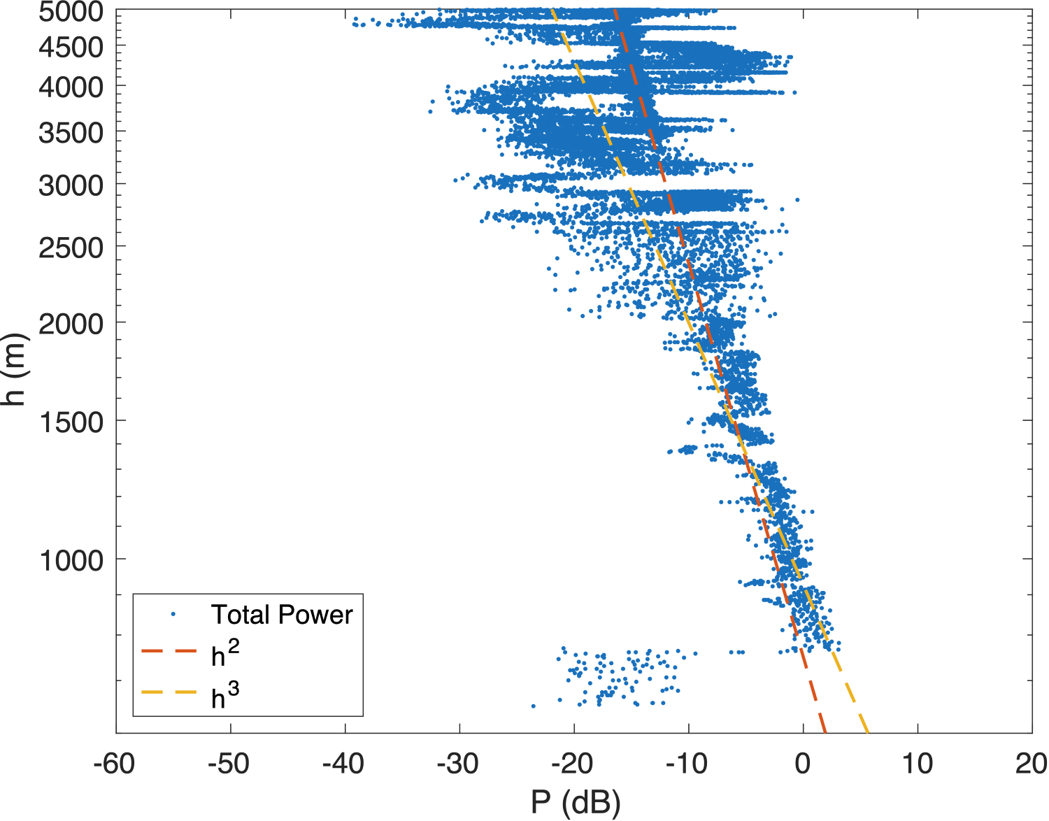
Fig 2. Observed surface power (P) over Beardmore Glacier for altitudes ranging from 600 to 5000 m.
References
[1] Daubar et al. (2024) SSR, 220(1), 18. [2] Moore et al. (1999) Icarus, 140(2), 294-312. [3] Grima et al. (2012) Icarus, 220(1), 84-99. [4] Chan et al. (2023) The Cryosphere, 17, 1839–1852. [5] Blankenship et al. (2024) SSR, 220(5), 51. [6] Bruzzone et al. (2015) IEEE IGARSS, 1257-1260. [7] Grima et al. (2014) P&SS, 103, 191-204. [8] Gerekos et al. (2023) Radio Science, 58(6), 1-30. [9] Haynes et al. (2018) IEEE TGRS, 56(11), 6571-6585 [10] Young et al. (2016) Phil Trans of the Royal Society A: MPES, 374(2059), 20140297
How to cite: Chan, K., Grima, C., Gerekos, C., Desage, L., Young, D., Blankenship, D., and Patterson, W.: Altitude-dependent radar reflectometry to characterize the near-surface of Jovian icy moons: perspectives from an Antarctic terrestrial analog, EPSC-DPS Joint Meeting 2025, Helsinki, Finland, 7–12 Sep 2025, EPSC-DPS2025-865, https://doi.org/10.5194/epsc-dps2025-865, 2025.