
 1,1,1,1,1
- 1INAF - Astronomical Observatory of Padova
- 2Centro di Ateneo di Studi e Attività Spaziali – Giuseppe Colombo (CISAS), Padova
Introduction:
Jules Verne is one of the prominent craters of the lunar farside. Its diameter is around 150 km and it is centered at 35°S, 147°E, just south of Gagarin crater and west of Mare Ingenii. Its age is estimated to be 4.21 Ga. [1], but it was involved in multiple volcanic events which reshaped its floor by filling it with basaltic mare-like material. This caused a resurfacing of the crater floor, accompanied by the formation of fractures, cracks and scarps [2,3]. Jules Verne crater shows a slightly irregular rim interrupted by multiple large superposed craters and a relatively shallow depth. It is also characterized by an extensive lobate scarps region which extends for tens of kilometers from the rim toward the floor. Recognizing various types of crater floor materials and volcanic features such as open cracks and pyroclastic deposits is essential for reconstructing the sequence of impact-related processes. Hence, to foster further study of this crater, we have prepared a high-resolution geologic map (scale 1:250.000) of the Jules Verne crater interior considering both geomorphological and spectral information.
Datasets and Methods:
To analyze the Jules Verne crater we exploited both morphological and multispectral data. As morphological data we used LROC-NAC (0.5 m/px) and WAC (100 m/px, Fig. 1A) [4] images coupled with the topographic data derived from the LOLA [5] and Kaguya [6] merged DEM (59 m/px).
For the multispectral analysis, we relied extensively on Clementine mosaic UVVIS Warped Color Ratio Mosaic [7]. This is traditionally displayed as an RGB false color composition with the following band ratios: Red = 750/415 nm; Green = 750/1000 nm; and Blue = 415/750 nm (Fig. 1B). We also used spectral maps derived from the Kaguya Lunar Multiband Imager [8], which display the percentage content of FeO (Fig. 1C), plagioclase (Fig. 1D), olivine (Fig. 1D), and orthopyroxene (Fig. 1E). The mapping has been conducted following established methodologies [10,11] and considering also the previous studies [1,2,3].
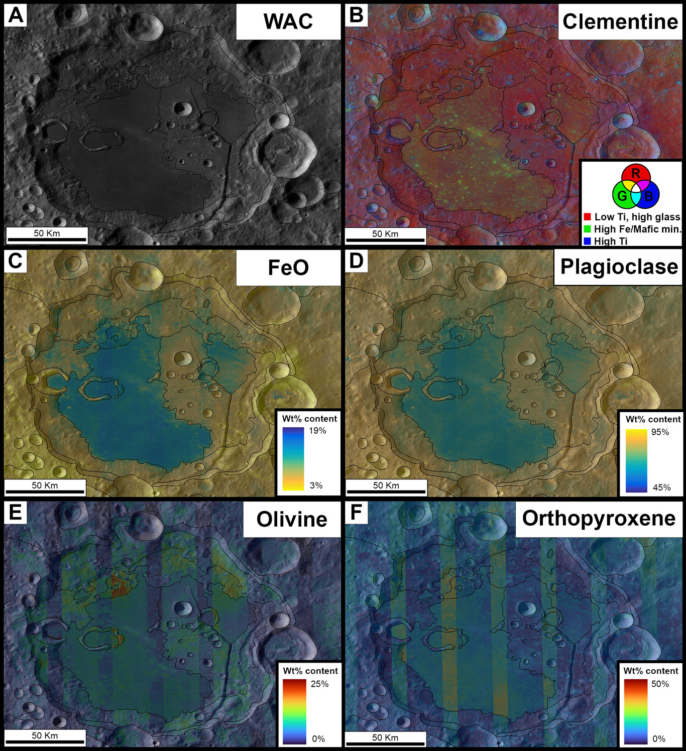
Fig. 1: A) WAC image of the Jules Verne crater, overlaid by different color palettes representing the: B) Clementine RGB false color composition data, where Red = high 750/415nm, Blue = high 415/750nm, and Green high 750/1000nm; C) Weight percentage content of FeO, D) Weight percentage content of plagioclase; E) Weight percentage content of Olivine; and F) weight percentage content of Orthopyroxene.
Results and future developments:
Within the resulting geologic map of the Jules Verne crater interior (scale 1:250.000, Fig. 2), we identified a total of 10 geologic units and 4 linear features which take also into account those already described by [2].
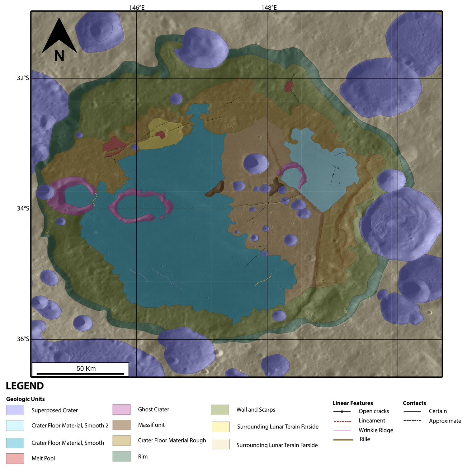
Fig. 2: Geologic Map of the Jules Verne crater with the corresponding legend shown on the right.
The Scarps unit encompasses the areas characterized by a relatively gentle slopes, which are located between the rim and the floor. The Wall unit corresponds to the steep slope just adjacent to the rim. The crater floor is characterized by four main units i.e. two smooth floor material (SF1 and SF2) and two rough floor material (RF1 and RF2). The first two units both appear as flattish regions mainly composed of basaltic mare-like material. However, SF1 shows lower TiO2 content and higher FeO content with respect to SF2, which appears more intermixed with or covered by with the rim material. On the other hand, RF units appear to resemble the highland-like units which surround the Jules Verne crater. Indeed, it shows high content in plagioclase and lower content in FeO, olivine, and pyroxenes. Specifically, RF1 is located adjacent to the crater’s wall, while RF2 is near to the center of the crater and surrounded by SF1 and SF2. Moreover, from a spectral point of view RF1 appears more intermixed with the highland-like material compared to the RF2 unit.
Many craters are superposed on these units. Those on top of SF1 and SF2 have diameters up to ~1.3 km and exposed stratigraphically lower and older material enriched in olivine. Conversely, those placed on top of RF1 unit appear larger (i.e. diameters up to ~11 km) and reveal lower layers with high plagioclase content, low olivine content, and compositionally similar to the rim or the surrounding highland material. Among the floor of the Jules Verne crater are also visible volcanic features which witness the past magmatic activity of the crater. Indeed, rilles, melt pools, pyroclastic deposits, open fractures, and lineaments are present. All these characteristics depict Jules Verne as result of an ancient impact that occurred in the Nectarian time and then involved in multiple volcanic events which reshaped the original crater floor, by infilling it with basaltic mare-like material. A complete version of the geologic map with further spectral sub-unit distinction will be presented at the conference.
This study provides an overview of the geologic units of the entire Jules Verne crater distinguished through spectral and morphological analyses. The same methodologies will be applied to the upcoming ESA-ASI LUMIO mission, which aims to observe impact flashes on the lunar farside with the collaboration of the LROC team. By exploiting these two datasets together it will be possible to produce pre and post impact geologic maps of the identified impacts, like the one presented in this work.
Acknowledgements: This research was supported by the Italian Space Agency under ASI-INAF grant agreement no. 2024-6-HH.0.
References: [1] Fortezzo C. et al., (2020). Proceedings of the 51st LPSC. [2] Wu C. et al., (2025). Remote sensing, 17, 1582. [3] Yigst, R.A.et al., (1999). J. Geophys. Res. 104, 1857-1879. [4] Robinson M.S., et al., (2010). Space Sci. Rev., 150(1–4), 81-124. [5] Smith D.E., et al., (2010). Space Sci. Rev. 150, 209-241. [6] Haruyama J., et al., (2008). Earth Planet. Sp., 60, 243 255. [7] Lucey P.G., et al., (2000). JGR. 105(E8), 20377-20386. [8] Ohtake M., et al., (2008). Earth Planets Sp., 60, 257-264. [10] Tusberti, F. et al., (2024). GFT &M, 16(1.1), 1-19. [11] Tusberti, F. et al., (2024). Icarus, 423, 116255.
How to cite: Tusberti, F., Pajola, M., Lucchetti, A., Penasa, L., Beccarelli, J., Rossi, C., and Munaretto, G.: Geological Map of the Jules Verne lunar farside crater (Moon), in the context of the Future Lumio Mission., EPSC-DPS Joint Meeting 2025, Helsinki, Finland, 7–12 Sep 2025, EPSC-DPS2025-966, https://doi.org/10.5194/epsc-dps2025-966, 2025.