
 1,21,2
- 1Università degli studi "G. d'Annunzio" Chieti - Pescara, Italy (gianluca.chiarolanza@unich.it)
- 2International Research School of Planetary Sciences, Pescara, Italy
INTRODUCTION
The upcoming ESA JUICE and NASA Europa Clipper missions will provide topographic data for Jupiter's icy moons, Ganymede and Europa, respectively. Both spacecraft will acquire stereo images using their onboard cameras: JANUS on JUICE [1], and EIS on Europa Clipper [2]. In addition, their radar sounders RIME [3] and REASON [4], primarily designed for subsurface sounding, will contribute to surface elevation measurements. JUICE is also equipped with the GALA laser altimeter [5], which will deliver precise elevation profiles along its ground tracks.
Beyond its primary science phase around Ganymede, JUICE will perform a series of targeted flybys of Europa and Callisto during its Jupiter tour [6]. These encounters offer an opportunity to image portions of their surfaces. However, due to mission design, topographic coverage will be limited by the number of planned observations, orbital geometry, and illumination conditions. As a consequence, some areas imaged during these flybys may lack a complementary observation necessary to: (1) form a stereopair suitable for standard stereophotogrammetric processing, or (2) support multi-view datasets for Shape-from-Shading (SfS) techniques [7].
One possible way to overcome this limitation is by searching for existing image data from previous missions that can be paired with newly acquired images to complete a stereopair [e.g., 8]. Even when the geometry does not support stereo processing, a second image may still be useful in multi-view SfS analyses. This study explores the feasibility and potential of this strategy, referred to here as the "multi-spacecraft" approach. This method is compared to the conventional "single-spacecraft" approach, where both images in a stereopair are taken by the same instrument, either through planned stereo imaging or serendipitous overlap.
To test this approach, we focus on Ganymede, which was imaged by NASA’s Juno spacecraft during a close flyby on 7 June 2021. JunoCam acquired four RGB images that enabled the generation of Digital Elevation Models (DEMs) for surface regions previously lacking detailed topographic coverage [9]. The first DEMs produced for these terrains were generated using standard stereo photogrammetry from JunoCam pairs, with supplemental photoclinometry applied where possible [9 - 10]. In a subsequent, independent study, higher-resolution DEMs over two selected regions were generated adopting a stereo vectorisation approach [11]. This method is based on an iterative process that involves measuring control points and vectors manually using stereo glasses and photogrammetric software. Importantly, stereo vectorisation was successfully applied not only to JunoCam stereopairs but also to multi-spacecraft stereopairs combining Juno and Galileo data.
PROPOSED WORKFLOW
In this study, we aim to identify one or more surface regions on Ganymede that have been imaged by multiple spacecraft at sufficient resolution to support stereo processing. Once such regions are identified, we will search for potential stereopairs in both the single-spacecraft and multi-spacecraft datasets. Each candidate pair will be assessed using established criteria for stereo suitability, including stereo angle, illumination compatibility, and ground sampling distance (GSD) [12].
For each selected area, two DEMs will be produced: one from a single-spacecraft stereopair and one from a multi-spacecraft stereopair. Both DEMs will be generated using the same photogrammetric software and workflow, specifically the Ames Stereo Pipeline [13], to ensure consistent processing. Quality assessments will follow established methodologies [14], allowing direct comparisons of elevation values and providing estimates on resolution and precision.
EXPECTED OUTCOMES AND TEST AREAS
The primary goal is to evaluate how closely the DEM generated from the multi-spacecraft pair matches the one produced from the single-spacecraft pair. The DEM from the single-spacecraft configuration will serve as a reference, while the multi-spacecraft DEM will be treated as the test case. Through this comparison, we aim to assess whether DEMs generated from multi-spacecraft image combinations are comparable in quality to those derived from single-spacecraft stereopairs, focusing on resolution and precision as indicators of quality.
One promising candidate for this analysis is the Enki Catena region (Figure 1), which has already been studied in previous works. DEMs for this area have been generated using both single-spacecraft (Juno-Juno) and multi-spacecraft (Galileo-Juno) stereopairs [10 - 11]. However, those studies used different processing techniques (standard stereogrammetry versus manual stereo vectorisation) making it difficult to isolate the impact of the data sources themselves. In our approach, both DEMs will be created using the same methodology and software, ensuring that any discrepancies observed can be attributed primarily to the nature of the input images, rather than differences in processing strategy.
This analysis will also help assess the practical advantages and limitations of the multi-spacecraft approach, such as expanded coverage, improved stereo angles, or increased complexity in image alignment and co-registration. Ultimately, the results could provide valuable guidance for future multi-mission data fusion efforts in support of JUICE, Europa Clipper, and beyond.
ACKNOWLEDGMENTS
G.C. and G.M. acknowledge support from the Italian Space Agency (2023-6-HH.0).
REFERENCES
[1] P. Palumbo et al., Space Sci. Rev., 2025.
[2] E. P. Turtle et al., Space Sci. Rev., 2024.
[3] L. Bruzzone et al., IEEE IGARSS, 2013.
[4] D. D. Blankenship et al., Space Sci. Rev., 2024.
[5] K. Enya et al., Adv. Space Res., 2022.
[6] ESA, JUICE Red Book, ESA/SRE(2014)1, 2014.
[7] O. Alexandrov and R. A. Beyer, Earth Space Sci., 2018.
[8] M. J. S. Belton et al., Science, 1996.
[9] M. A. Ravine et al., Geophys. Res. Lett., 2022.
[10] P. Schenk et al., LPSC, 2022.
[11] I. E. Nadezhdina et al., Planet. Space Sci., 2024.
[12] K. J. Becker et al., LPSC, 2015.
[13] R. A. Beyer et al., Earth Space Sci., 2018.
[14] R. L. Kirk et al., Remote Sens., 2021.
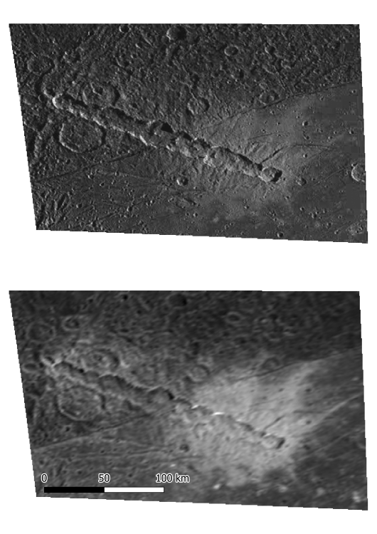
Figure 1 Enki Catena region on Ganymede, as seen in a multi-spacecraft stereopair formed by a Galileo SSI frame (top) and a JunoCam frame (bottom), both map-projected to Simple Cylindrical.
How to cite: Chiarolanza, G. and Mitri, G.: Evaluating Multi-Spacecraft Stereo Imaging for DEM Generation on Ganymede, EPSC-DPS Joint Meeting 2025, Helsinki, Finland, 7–12 Sep 2025, EPSC-DPS2025-996, https://doi.org/10.5194/epsc-dps2025-996, 2025.