
Geomorphological analysis with digital elevation model of Monad Regio, Triton
 1,2,1,2,1,2,1,2
- 1International Research School of Planetary Sciences, Pescara, Italy (camilla.cioria@unich.it)
- 2Dipartimento di Ingegneria e Geologia, Università d’Annunzio, Pescara, Italy.
Triton is one of the few satellites in the Solar System which shows an ongoing geological activity, with plumes and geysers whose origin is still controversial [1]. Its surface is relatively young, as shown by the paucity of craters detected on its surface [2]. Our knowledge of this moon comes from the Voyager 2 mission, which obtained several images, covering about 40% of Triton’s surface [3]. However, few studies were focused principally on surficial geomorphology, and those are mostly limited to the cantaloupe region and surrounding areas. Triton’s crust is composed predominantly by solid nitrogen (N2) but several other ices have been detected [3]. Crater counting has revealed that the surface is very young and likely it went through a resurfacing process in the past. In fact, a very small number of craters has been detected, and these usually exhibit a typical bowl-like shape [2]. Geological features on Triton include regions, called terrains, such as cantaloupe terrains or plains, which show different textures. Usually, plains are categorized within smooth, walled and terraced plains [3]. The latter are the flattest areas on Triton, a characteristic which has been explained by evoking a lava-like or other viscous liquid infill. Their central depressions also present a cluster of irregular pits, which have been interpreted as drainage pits or eruptive vents [3]. These peculiar morphologies seem to indicate the presence of a viscous fluid on the surface in a remote epoch, which may imply potential climatic and atmospheric changes during Triton’s geological history. In this work we analyse an area located at NW of Tuonela Planitia, which shows several depressions rimmed by sharp margins. Two of these depressions are named Kulilu Cavus and Mah Cavus [4]. Cavi are elliptical-shaped depressions, distributed in an ordered trend, which constitute the cantaloupe terrain [3]. Diapirism is the main candidate process to explain these collapsed depressions [3] but other hypotheses, such as cryovolcanism or impact cratering [5], have also been proposed.
Methodology
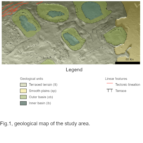
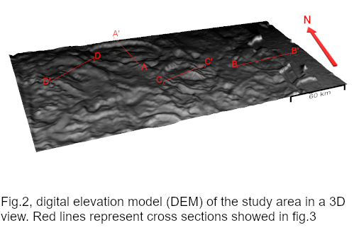
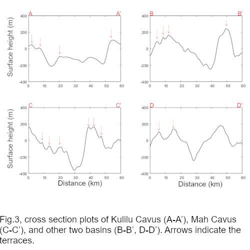
A new geological map has been realized. We used Voyager 2 imagery named c1139533 [6] (600 m/px), properly calibrated, filtered and georeferenced using the Integrated Software for Imagers and Spectrometers (ISIS4) [7]. We mapped the different geological units and main features according to differences in surface morphology (fig.1). We also produced a DEM of the study area, using the open-source suite of tools NASA Ames Stereo Pipeline (ASP) [8]. We applied the photoclinometry-based “shape-from-shading” (SfS) tool to produce the DEM. Since SfS needs an input DEM generated preferably with stereo images, and we do not have such data for Triton, we used the methodology proposed by Lesage et al. 2021[9]. We analysed four different cross sections to measure the relative height of Kulilu Cavus, Mah Cavus and two other depressions, as well as their associated terraces (fig.2).
Discussion
Geological map in fig.1 comprises four units: terraced terrain (tt), smooth plain (sp), outer basin (ob), inner basin (ib). Terraced terrain covers most of the studied area. It shows a chaotic pattern characterized by a non-linear distribution of elevations (fig.3). Several terraces have been spotted, some of which lay in a parallel arrangement around some of the basins. In cross section plots (fig.3) we observed two different trends in the progressive elevation of terraces, as they approach the basins. Particularly, in sections A-A’ and C-C’ we identified a decrease in the terraces’ height towards the corresponding basin, instead in B-B’ and D-D’ we found an increase of height. In the E part of the study area, the terraced terrain ends abruptly with a sharp-edged scarp, passing to the smooth plain unit (sp). By analysing DEM topography, we observed that sp unit lays 250 m below tt unit. The latter surrounds Tuonela Planitia, one of the four main walled plains identified on Triton. The terraced terrain hosts several large basins, with areas ranging from 1300 to 2050 km2. The degree of alteration among these basins is variable, with the features inferred to be more recent showing an inner minor basin within the main basin. The most altered basins appear smoother, featureless and shallower. Cross sections plots (fig.3) show that the depths of these basins range from 300 to 500 m. Finally, we can argue a tectonic control of this area, represented in the NW part of the terraced terrains by several lineations included in a wider ridge (outside the study area), which is part of the global tectonic grid on Triton.
Conclusions
Sizes and excavation depths of the observed basin features appear to be relatively homogeneous, which leads us to exclude an impact related origin. Instead, we argue that the origin of these depressions is linked to processes analogue to those described, in the formation of terrestrial maar craters [10] and possible explosion craters discussed on Titan [11]. Alternatively, diapirism may also explain the origin of such features. Further analysis could help to understand the nature and related processes that originated these basins.
Acknowledgements
G.M., C.C., D.S., acknowledge support from the Italian Space Agency (2020-13-HH.0).
References: [1] Hansen C.J., and Kirk R. (2015), 46th LPSC, 2423.[2] Schenk P.M., and Zahnle K. (2007), Icarus, Vol.192(1), 135-149.[3] McKinnon B. M. and Kirk R.L. (2014), Chapter 40, Triton, Encyclopedia of the Solar System, Third edition, Elsevier,861-881.[4] USGS Astrogeology Science Center: Triton Pictorial Map of the Slidr Linea Quadrangle (Nt-2), 1992.[5] Martin-Herrero A. et al. (2014), 45th LPSC, 1177.[6] Smith, B. A., et al. (1989), Science, Vol.246 (4936), 1422-1449.[7] Houck J.C. and DeNicola L.A. (2000) Astronomical Data Analysis Software and Systems IX, ASP Conference Series, Vol. 216.[8] Beyer, R. A. et al. (2018), Science, 5.[9] Lesage E. et al. (2021), Icarus, 114373.[10] Lorenz, V. (2003), Geolines, Vol.15, 72-83.[11] Mitri G., et al. (2019), Nature Geoscience, Vol. 12, 791,796.
How to cite: Cioria, C., Sulcanese, D., Chiarolanza, G., and Mitri, G.: Geomorphological analysis with digital elevation model of Monad Regio, Triton, Europlanet Science Congress 2021, online, 13–24 Sep 2021, EPSC2021-135, https://doi.org/10.5194/epsc2021-135, 2021.