Mineralogical and Geomorphological Characterisation of a 20-km-wide Crater in Older Meridiani Planum, Mars
- 1Department of Physics, Sapienza University of Rome, p.le Aldo Moro 2, 00185 Rome, Italy (beatricebaschetti@gmail.com)
- 2INAF/IAPS, via del Fosso del Cavaliere 100, 00133 Rome, Italy
- 3Department of Chemistry, Life Sciences and Environmental Sustainability, Università degli Studi di Parma, Viale delle Scienze 157/A, 43121 Parma
Introduction: Meridiani Planum is a relatively plain area located at the Martian equator, south of Arabia Terra, approximately ranging from longitude 350°E to 10°E. Heavily cratered Noachian-aged terrains constitute the oldest geological unit in the region, where several channels and valley networks have left their imprint on the surface [1]. A series of younger terrains were then emplaced in some areas, likely during Late Noachian/Early Hesperian epochs [2].
Meridiani Planum shows signs of a diversified and complex history of aqueous activity in many locations. In addition to the evidence provided by the numerous valley networks, data from OMEGA and CRISM orbital spectrometers have revealed the presence of Fe/Mg phyllosilicates and sulfates throughout the area [3]. These hydrated minerals usually form by alteration in aqueous environments. Older, Noachian-aged, areas are generally characterized by the presence of Fe/Mg phyllosilicates, while younger capping units may display both phyllosilicates and sulfates. Regional differences in mineralogy, hydration, and morphology imply that the aqueous conditions probably varied over time.
Advancing our knowledge on the aqueous processes that left their imprint on this area could provide new insight on the past climate and habitability of Mars. Noachian terrains are of particular interest, as they date back to a period which is largely recognized as the most suitable for hosting habitable conditions on the planet.
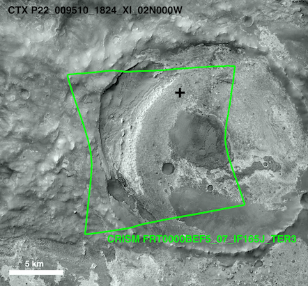
Materials and method: We selected a small crater in the northern part of Meridiani Planum (figure 1), centred at 359.96°E, 2.45°N and approximately 20 km wide. The crater is part of the exposed Noachian-aged terrains of the region and is surrounded to the south and east by younger terrains, which overlie part of its ejecta.
Both mineralogical and geomorphological characteristics were investigated using MRO-based instruments CRISM, HiRISE and CTX. Infrared data (1.0-2.6 μm) from CRISM spectrometer was used to assess the mineralogical composition of the terrains inside the crater. This information was then integrated with HiRISE high-resolution camera data to identify and correlate with compositional information the different morphologies within the crater's area. Additionally, images from CTX camera were used to provide surrounding context.

Figure 1: CTX image of the region of interest. The green lines trace CRISM footprint, showing the coverage of the spectral data analysed.
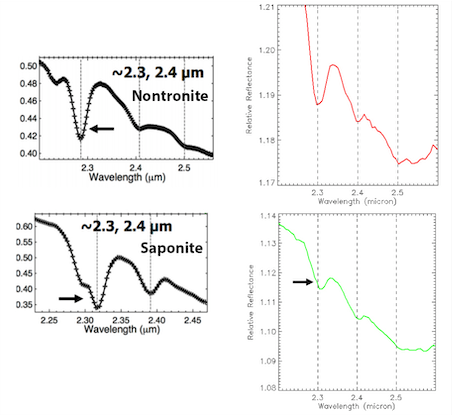
Results: Phyllosilicates, specifically Fe/Mg-rich smectite clays, are found in a wide area of the crater’s interior. The spectra obtained from CRISM are displayed in figure 2, they show absorption features near 1.4, 1.9, and 2.3 μm, with additional combination tones near 2.4 μm, and sometimes 2.5 μm. The exact position of some bands depends on the relative proportions of Fe and Mg: for example, the 2.3 μm band shifts to shorter wavelengths as Fe is exchanged for Mg [4].
We identify two distinct spectral classes for the smectites (Figure 2): the first is compatible with laboratory spectra of Fe-rich smectites, e.g. nontronite, while the second with the spectra of more Mg-rich smectites, such as saponite. The position and shape of the 2.3, 2.4 and 2.5 μm features are slightly different for the two classes. Figure 3 shows the absorption details for both CRISM and laboratory spectra.
Fe-rich smectites tend to be concentrated in limited areas of the crater, mostly close to its southern border. Further investigation is needed on this point to clarify the reasons for this specific distribution.
Figure 2: averaged spectra obtained for the areas which show the presence of Fe/Mg smectites: red is from predominantly Fe-rich smectite areas, green is from Mg-rich areas.

Figure 3: (left) Laboratory spectra of Nontronite (Fe-rich smectite) and Saponite (Mg-rich smectite). (right) Absorption details of the spectra from figure 2.
The spectral signature of the remaining terrains implies the presence of pyroxenes. Usually, these areas tend to be darker and dunes of a fine-grained material are frequently observed.
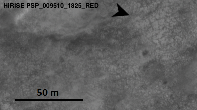
Terrains which retain signs of hydration show an interesting variety of morphologies, however, a common feature is that they all show polygonal fracture patterns to some extent (figure 4).

Figure 4: Cracking patterns on the crater’s hydrated terrains as observed with HiRISE. Approximate location is marked by a plus sign in figure 1.
Interpretation and discussion of the results: A possible explanation for the observed cracking patterns is related to desiccation. Desiccation is caused by water evaporation or migration: as a result of the water loss, the terrain shrinks and cracks.
Cracking patterns, correlating with the presence of sedimentary materials (e.g. clays or sulfates), are found in various Martian terrains and could be markers of ancient lacustrine environments [5]. The Noachian geologic setting, in association with terrains that show evidence of past aqueous activity, reinforces this hypothesis.
Noachian paleo-lakes are a top-priority setting for astrobiological research as they might have been suitable environments to support and preserve traces of microbial life [6]. Nevertheless, a different origin for these features is not ruled out and further investigation is required.
Conclusions: Meridiani Planum is undoubtedly an area which was subject to significant water alteration. Fe/Mg smectites detected in the northern Noachian-aged terrains of Meridiani Planum, in association with polygonal fracture patterns, could be related with the existence of ancient paleo-lake environments, making this area an interesting spot for astrobiological research. The information available on these areas is still limited: in order to provide context to MER Opportunity’s observations, previous studies mainly focused on the younger capping terrains lying south of the crater we examined. The results obtained here can be a worthwhile starting point for better understanding the evolutionary history of Meridiani Planum’s oldest terrains.
Acknowledgments: Featured camera images were obtained from NASA’s Planetary Data System (PDS).
References: [1] Williams et al. (2017) GRL, 44, 1669-1678. [2] Hynek et al. (2002) JGR, 107, 5088. [3] Flahaut et al. (2015) Icarus, 248, 269-288. [4] Viviano-Beck et al. (2014) JGR, 119, 1403-1431. [5] El-Maarry et al. (2014) Icarus, 241, 248-268. [6] Vago et al. (2017) Astrobiology, 17,471-510.
How to cite: Baschetti, B., Altieri, F., Carli, C., Frigeri, A., and Sgavetti, M.: Mineralogical and Geomorphological Characterisation of a 20-km-wide Crater in Older Meridiani Planum, Mars, Europlanet Science Congress 2021, online, 13–24 Sep 2021, EPSC2021-143, https://doi.org/10.5194/epsc2021-143, 2021.

